Malaysia Airlines Plane "Loses Contact"
Discussion


The Inmarsat analysis of the ACARS in-flight ping data does not convince me that the plane went down in the Southern Ocean. A proper technical description of how it was done has not been published. All I've heard is a basic description on the Doppler effect, and some comparisons to previous flights. It seems strange to me that all aircraft ACARS RF transmissions are routinely recorded to such a level of detail to enable burst frequency offset and doppler analysis to be carried out.
I'm also not convinced that they have picked up any signals from the voice recorder or FDR from MH370, at the bottom of the Southern Ocean. It has been reported that signals that "were considered to be consistent with signals expected from an aircraft's flight recorder", have been picked up at various locations, for varying periods of time. Surely there can't be too many aircraft black boxes lying about on the ocean floor - so were the signals from MH370's black boxes or not? We were told that the signals would last for "about a month". The aircraft went missing on the 8th of March, with the last undersea signal being picked up on the 8th of April, exactly one month later...
The plane could still be anywhere within a 2500 mile radius of KL.
Looks like they are going back to square one:
http://www.huffingtonpost.co.uk/2014/04/22/mh370-m...
Edited by GSE on Wednesday 23 April 16:04
[quote=GSE]
Looks like they are going back to square one:
http://www.huffingtonpost.co.uk/2014/04/22/mh370-m...
Headline of the above article: "Malaysian Flight MH370 May Not Be In Southern Indian Ocean, Official Admits"
Well, f k me sideways. This is what a lot of us have been saying all along. I've never understood why the search hasn't been continued over the possible overland flight paths. Maps were shown on here pages ago which show that the Southern Indian Ocean wasn't the only possible final destination of the flight – and I'll leave outer space out of it this time ;-)
Looks like they are going back to square one:
http://www.huffingtonpost.co.uk/2014/04/22/mh370-m...
Headline of the above article: "Malaysian Flight MH370 May Not Be In Southern Indian Ocean, Official Admits"
Well, f
k me sideways. This is what a lot of us have been saying all along. I've never understood why the search hasn't been continued over the possible overland flight paths. Maps were shown on here pages ago which show that the Southern Indian Ocean wasn't the only possible final destination of the flight – and I'll leave outer space out of it this time ;-)I am convinced that the relevant authorities know where MH 370 is, the engine monitoring telemetry is monitored all the time AFAIK, with the relevant information supplied on a " subscription basis".
I suspect that the people who had the information about the crash site have probably been relieved of the responsibility of keeping it quiet from the media, I would start looking at where military vessels, particularly ones flying the Stars and Stripes or the Union Flag have been stationary for some relevant time in the Southern Hemisphere, possibly not in the Southern Ocean but the Coral sea or Pacific.
The whole affair smells fishy to me, it reeks of high level Government cover up for whatever reason, possibly terrorism , the Malaysians do not have the raw satellite information to which the the US and Brits have access ,I'm guessing that someone, somewhere doesn't want the truth to emerge, well maybe not just yet.
rolando said:
Hard luck, the BBC report says '…the debris looked like sheet metal with rivets in it, but added: "The more we look at it, the less excited we get."'
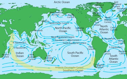
If you look at the maps of the currents, such as the above, *if* the aircraft crashed in the sea as it's been said, it is possible that floating debris might eventually reach the coasts of WA.
Searching around for some information about the Western Australian current, I found that its average speed is about 0.5 Knots, i.e. that in ideal conditions debris could travel 12 Nautical Miles a Day.
Since 46 days have passed since the accident, debris could have travelled for over 500 nautical miles towards the Australian coast, which would still be not enough if it's true that the plane went down more than 1.000 Miles off Australia.
Of course floating debris are subject to wind and waves, so my calculation can be by a large margin inaccurate and -if taken in a West to East trade wind- speed of objects on the surface of the sea travelling in that direction might be much higher than in calm conditions.
After all if the plane is where they say it might just be a matter of time until something is washed ashore... the question is, given the length of the Aussie coast, will it ever be spotted?
Auntieroll said:
I am convinced that the relevant authorities know where MH 370 is, the engine monitoring telemetry is monitored all the time AFAIK, with the relevant information supplied on a " subscription basis".
I suspect that the people who had the information about the crash site have probably been relieved of the responsibility of keeping it quiet from the media, I would start looking at where military vessels, particularly ones flying the Stars and Stripes or the Union Flag have been stationary for some relevant time in the Southern Hemisphere, possibly not in the Southern Ocean but the Coral sea or Pacific.
The whole affair smells fishy to me, it reeks of high level Government cover up for whatever reason, possibly terrorism , the Malaysians do not have the raw satellite information to which the the US and Brits have access ,I'm guessing that someone, somewhere doesn't want the truth to emerge, well maybe not just yet.
http://www.lme.com/en-gb/metals/non-ferrous/alumin...I suspect that the people who had the information about the crash site have probably been relieved of the responsibility of keeping it quiet from the media, I would start looking at where military vessels, particularly ones flying the Stars and Stripes or the Union Flag have been stationary for some relevant time in the Southern Hemisphere, possibly not in the Southern Ocean but the Coral sea or Pacific.
The whole affair smells fishy to me, it reeks of high level Government cover up for whatever reason, possibly terrorism , the Malaysians do not have the raw satellite information to which the the US and Brits have access ,I'm guessing that someone, somewhere doesn't want the truth to emerge, well maybe not just yet.
See what happens when people start panic buying bacofoil?
jmorgan said:
MartG said:
TTmonkey said:
Me neither. No one has yet explained the massive slice of luck involved in suddenly searching a new area and detecting a 'signal'. The planes were originally searching over a thousand miles south west of the place where they suddenly decided to look for signals.
Or 'luck' = data from a hunter/killer sub that is kept quiet to preserve secrecy on how good its detection kit is 
The military must have the ability to find almost anything on a sea bed. I can't believe the Bluefin is the best technology there is by a looong way.
Auntieroll said:
I would start looking at where military vessels, particularly ones flying the Stars and Stripes or the Union Flag have been stationary for some relevant time in the Southern Hemisphere, possibly not in the Southern Ocean but the Coral sea or Pacific.
Was MH370 burning some sort of special long range fuel that THEY didn't want China to find out about? I think we should also mention the HAARP programme - I don't know why but it seems like the standard response to this sort of thing.Vaud said:
IF you subscribe, it isn't mandatory, and not every carrier does.
I am led to believe that the subscription is to pay for the relevant comms satellite forwarding service for the telemetry information, this information AFAIK IS available to RR, I wonder if the relevant info was collected by someone and "removed to a place of safe keeping" for someones greater good. Just a thought.GSE said:
It seems strange to me that all aircraft ACARS RF transmissions are routinely recorded to such a level of detail to enable burst frequency offset and doppler analysis to be carried out.
Easy to assume that I agree. However don't forget that this type of aircraft monitoring is happening on a global beam, not a regional beam. If it was on a regional beam then there would be hand over records as the aircraft moved from one region to another and it would be much easier to decide where the aircraft went.On a global beam there would be (are) timing correction messages sent back and forth to the aircraft as it 'moves around' the Earth.
Inmarsat make their money by selling satellite bandwidth. On a global beam, that bandwidth is extremely precious, the requirement to minimalise guard band timing is crucial to them maximising profit.
They monitor and record everything that is happening on their network.
GSE said:
It seems strange to me that all aircraft ACARS RF transmissions are routinely recorded to such a level of detail to enable burst frequency offset and doppler analysis to be carried out.
It might be worth rechecking, but if my memories are correct I seem to recall that Inmarsat recorded pings from many different planes in the area AFTER the accident, when the possibility of using this type of data to recreate the flight plan arose.TheExcession said:
asy to assume that I agree. However don't forget that this type of aircraft monitoring is happening on a global beam, not a regional beam. If it was on a regional beam then there would be hand over records as the aircraft moved from one region to another and it would be much easier to decide where the aircraft went.
On a global beam there would be (are) timing correction messages sent back and forth to the aircraft as it 'moves around' the Earth.
Inmarsat make their money by selling satellite bandwidth. On a global beam, that bandwidth is extremely precious, the requirement to minimalise guard band timing is crucial to them maximising profit.
They monitor and record everything that is happening on their network.
It's a long time since I worked on news feeds via Satcomms. where I do remember no end of frame and packet data being recorded, but couldn't recall if or how the timing was recorded. It's obviously a much more complicated scenario with moving planes involved. Thanks for your explanation, it's making sense now. On a global beam there would be (are) timing correction messages sent back and forth to the aircraft as it 'moves around' the Earth.
Inmarsat make their money by selling satellite bandwidth. On a global beam, that bandwidth is extremely precious, the requirement to minimalise guard band timing is crucial to them maximising profit.
They monitor and record everything that is happening on their network.
AlexIT said:
It might be worth rechecking, but if my memories are correct I seem to recall that Inmarsat recorded pings from many different planes in the area AFTER the accident, when the possibility of using this type of data to recreate the flight plan arose.
Yes that's what I read as well. I'd love to look at the raw data 
So it looks like it may have gone down in the Southern Ocean...
But there still seem to be too many unanswered questions. and a feeling that the authorities know rather more than has been released.
I'm waiting for the inevitable "the search is being scaled down" announcement.
GSE said:
AlexIT said:
It might be worth rechecking, but if my memories are correct I seem to recall that Inmarsat recorded pings from many different planes in the area AFTER the accident, when the possibility of using this type of data to recreate the flight plan arose.
Yes that's what I read as well. I'd love to look at the raw data So it looks like it may have gone down in the Southern Ocean...
But there still seem to be too many unanswered questions. and a feeling that the authorities know rather more than has been released.
I'm waiting for the inevitable "the search is being scaled down" announcement.
One way or another the truth will out in this tragedy and I am hopeful still that some indication may be found as to how the tragedy unfolded. It cannot have just disappeared there will be physical evidence to some extent somewhere and in time it will be found. How long that will be is the real imponderable but giving up will not happen. Matter of time.
AlexIT said:
the question is, given the length of the Aussie coast, will it ever be spotted?
If it hits the south west, probably.Not massively populated, but a lot of people go on a lot of beaches.
It's popular for 4x4s, fishing, surfers to get away from everyone else.
Example - Me. I live in Perth, and last weekend I was on a beach down there (wind was too strong to do any fishing though).
If anything washes up from Geraldton to Albany I recon someone will find it.
If it goes further round south, or north .. it'll be a different story.
Cheib said:
jmorgan said:
MartG said:
TTmonkey said:
Me neither. No one has yet explained the massive slice of luck involved in suddenly searching a new area and detecting a 'signal'. The planes were originally searching over a thousand miles south west of the place where they suddenly decided to look for signals.
Or 'luck' = data from a hunter/killer sub that is kept quiet to preserve secrecy on how good its detection kit is The military must have the ability to find almost anything on a sea bed. I can't believe the Bluefin is the best technology there is by a looong way.
I expect we will find out a later.
Edit. Sorry for the wiki link. clicky
Edited by jmorgan on Thursday 24th April 06:41
MH370 Landed Safely Somewhere As No Debris Found Yet - http://au.ibtimes.com/articles/549190/20140423/mh3...
Comment on the article -
Comment on the article -
Mike215 said:
I will tell you what happened to the plane. It was deliberately blown up to prevent its two MUSLIM PILOTS from making a suicide run on Petronas Twin Towers in downtown Kuala Lumpur. How did the the authorities know it was a suicide run? Because the Muslim pilots were following the actions of the four Muslim pilots in the 911 attacks: first, cut off all verbal communication; two, disable the tracking electronics; and three, change course without permission Once they changed course the authorities had only 20 or so minutes before the plane would hit the towers so they had to act fast and blow it up. The wreckage was probably collected as soon as possible.
These stories that the plane flew for thousands of miles with everybody dead was fiction just as the stories now that it landed somewhere. It cannot be admitted that the plane was deliberately destroyed.
These stories that the plane flew for thousands of miles with everybody dead was fiction just as the stories now that it landed somewhere. It cannot be admitted that the plane was deliberately destroyed.
john2443 said:
MH370 Landed Safely Somewhere As No Debris Found Yet - http://au.ibtimes.com/articles/549190/20140423/mh3...
Comment on the article -
And no-one thought to evacuate the buildings in KL just in case another aircraft got through? Comment on the article -
Mike215 said:
I will tell you what happened to the plane. It was deliberately blown up to prevent its two MUSLIM PILOTS from making a suicide run on Petronas Twin Towers in downtown Kuala Lumpur. How did the the authorities know it was a suicide run? Because the Muslim pilots were following the actions of the four Muslim pilots in the 911 attacks: first, cut off all verbal communication; two, disable the tracking electronics; and three, change course without permission Once they changed course the authorities had only 20 or so minutes before the plane would hit the towers so they had to act fast and blow it up. The wreckage was probably collected as soon as possible.
These stories that the plane flew for thousands of miles with everybody dead was fiction just as the stories now that it landed somewhere. It cannot be admitted that the plane was deliberately destroyed.
These stories that the plane flew for thousands of miles with everybody dead was fiction just as the stories now that it landed somewhere. It cannot be admitted that the plane was deliberately destroyed.

Gassing Station | News, Politics & Economics | Top of Page | What's New | My Stuff