Parking/RoW/Unadopted road
Discussion


I just checked streetview for one of the unadopted roads near me, and it has no additional wording on the street roadname sign.
Also, the Google mapping car has not driven down it, despite the facts that ist a straight avenue with an entry at both ends. All other local roads and closes have been photoed.
Also, the Google mapping car has not driven down it, despite the facts that ist a straight avenue with an entry at both ends. All other local roads and closes have been photoed.
Jobbo said:
surveyor said:
I've never seen 'unadopted' on any sign.
They do exist: https://goo.gl/maps/mrQYR8HtP5J2
There are actually quite a few near where i live - proper council street signs with (Unadopted) or variations there of on them.
As ever though the easiest way to tell is it it looks like it was last tended to in 1867. Does not alway work though . In some places (Lowestoft leaps to mind) there are loads of unadopted access roads behind 1890's terrace streets which the council gets resurfaced, whilst flatly denying any liability to do so or to deal with any other related issues.
Jobbo said:
surveyor said:
I've never seen 'unadopted' on any sign.
They do exist: https://goo.gl/maps/mrQYR8HtP5J2Thanks for all the input - much appreciated!
I suspect that, given the general difficulty in finding a space to park in the evenings, the owners of the house in question have put the signs up to ensure they are able to park adjacent to their house. Much as it's going to be a pain, I think the gentlemanly thing to do is leave them to it and hope that it doesn't cause too many problems with the rest of us fighting for the remaining available places to park!
Still, we chose to live in a house with no guaranteed parking as it was cheap for what it was otherwise - that's the risk we took.
Jobbo said:
surveyor said:
But rare and no real judgement can be formed from its absence
Oh, absolutely - but it's quite clearly not adopted. However, it also looks very much like it's public highway. (I know of some officers that don't even understand the difference
  )
)Jobbo said:
surveyor said:
I've never seen 'unadopted' on any sign.
They do exist: https://goo.gl/maps/mrQYR8HtP5J2Also it has disappeared in this later Streetview - https://goo.gl/maps/ychTx3bd3M72
These ones are:
https://goo.gl/maps/YVXiqqET14A2
http://londonisforliving.com/wp-content/uploads/20...
This one shows an example of an old style cast iron sign which has remained whereas the street name one has been replaced by a more modern one.
https://goo.gl/maps/8y1ot1anXt62
Red Devil said:
I don't think that one is a local authority sign though. It is a different shade of blue from all the others in the locality.
Also it has disappeared in this later Streetview - https://goo.gl/maps/ychTx3bd3M72
I'm pretty sure it is - it's the same metal sign and the only reason it's faded is that it's been there so long. The road was (prior to the first Streetview visit in 2009) visibly unadopted; the housing development which led to it being tarmacked is the reason it was removed.Also it has disappeared in this later Streetview - https://goo.gl/maps/ychTx3bd3M72
Jobbo said:
The road was (prior to the first Streetview visit in 2009) visibly unadopted; the housing development which led to it being tarmacked is the reason it was removed.
Are you saying that road is now adopted? If so I would have expected the local authority to have provided a new sign similar to all the others in that area. Also, why hasn't the sign on the wall of the adjacent property on the right been removed? A tarmac surface does not per se automatically mean that the local authority has adopted a road. Furthermore, a search of Worcestershire County Council's list of unclassified roads in Redditch shows that The Rough is not included whereas Highfield Avenue opposite is (U30117). I remain of the opinion is was not a local authority sign. Not only is the colour the wrong shade, the typeface/font is different and it does not have the HEADLESS CROSS wording common to all the other nearby signs either. My guess is that it either fell down and was not reinstated or the local authority required its removal at some point between 2009 and 2014 after the development had been completed.
Red Devil said:
Are you saying that road is now adopted? If so I would have expected the local authority to have provided a new sign similar to all the others in that area. Also, why hasn't the sign on the wall of the adjacent property on the right been removed? A tarmac surface does not per se automatically mean that the local authority has adopted a road. Furthermore, a search of Worcestershire County Council's list of unclassified roads in Redditch shows that The Rough is not included whereas Highfield Avenue opposite is (U30117).
I remain of the opinion is was not a local authority sign. Not only is the colour the wrong shade, the typeface/font is different and it does not have the HEADLESS CROSS wording common to all the other nearby signs either. My guess is that it either fell down and was not reinstated or the local authority required its removal at some point between 2009 and 2014 after the development had been completed.
I didn't say it's now adopted - it's simply now been tarmacked. Sadly I can't find any photos of the road before it was developed.I remain of the opinion is was not a local authority sign. Not only is the colour the wrong shade, the typeface/font is different and it does not have the HEADLESS CROSS wording common to all the other nearby signs either. My guess is that it either fell down and was not reinstated or the local authority required its removal at some point between 2009 and 2014 after the development had been completed.
I have no specific knowledge that it's a local authority sign, but I remember it from the 1980s onwards which is why I linked to it in this thread. If it's not local authority, somebody went to a bizarre amount of effort to recreate a very similar style of sign which remained in place for 25+ years.
I had an almost identical end terrace and unadapted road set up to the one who is putting the signs up. Turned out in the deeds, it stated that I owned 15 feet out from the gable end, as did my neighbour across the unadopted road. That left a similar 15 foot stretch down the middle for access to the alleyways at the back.
When we both realised this and did what your neighbour has done, it caused some frustration locally, but I was happy to explain it for a while. Then I got bored and turned it into an enclosed driveway, that did cause some upset.
When we both realised this and did what your neighbour has done, it caused some frustration locally, but I was happy to explain it for a while. Then I got bored and turned it into an enclosed driveway, that did cause some upset.
Swervin_Mervin said:
snorky782 said:
Turned out in the deeds, it stated that I owned 15 feet out from the gable end, as did my neighbour across the unadopted road.
That's fairly typical of any road, adopted or not.Jobbo said:
Swervin_Mervin said:
snorky782 said:
Turned out in the deeds, it stated that I owned 15 feet out from the gable end, as did my neighbour across the unadopted road.
That's fairly typical of any road, adopted or not.Having to explain to people that they can't do what they like with it, when they find this out though...painful.
Has anyone looked at the Title of the property in question?
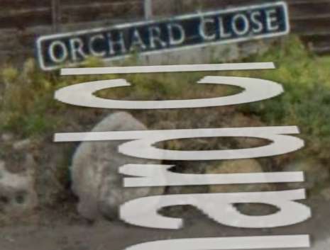
I have now looked at the Title. The road (assuming its Orchard Close) is all owned by the property on the right.
If its Orchard Road then the road is unregistered and does not belong to any of the adjacent properties unless its been held in a separate title with no changes of ownership since before compulsory registration in 1990
Edited by blueg33 on Thursday 5th May 15:52
The house that has the signs on it side (looks like number 135 on street view), is located on "lower Weybourne Ln". The unadopted/private road in question is "Orchard Rd"
So surely that house cannot have any claim over road space on a unadopted/private road that they don't actually live on?
So surely that house cannot have any claim over road space on a unadopted/private road that they don't actually live on?
Gassing Station | Speed, Plod & the Law | Top of Page | What's New | My Stuff