Yorkshire moor road 3d modelling, Carto/OS question...
Discussion


What I'm doing is modelling for a car game/simulation a certain moor road from the UK... Call it a hobby/obsession doing this kind of thing. The road runs from Otley, up over the moor and then meets up with the A59 at Blubberhouses.
Just curious if anyone here works in Cartography and uses the latest mapping data and knows if anything would be suited to what I'm after.
I worked for DEFRA doing carto many moons ago and the landline data was just the kinda thing I need for the top down layout, just curious if anything now exists that has the height data too. As in accurate enough for say every 10m or so and also with good +/- error accuracy.
There are a few companies who sell this data via OS, just I want to know if anyone can suggest the best route to go before I buy data that is potentially no better than my extrapolated contour/road intersection and 1:10k raster data I've used.
So, if anyone works with the latest OS digital stuff, or can recommend a company where I can get raster outputs of vector data from OS any links or advice would be much appreciated!
Tis a road worthy of digitalisation to 3d. Anyone who knows the road will appreciate it's a large task but well worth it. Used to live out that way and drive it every day, what a way to start and end a commute. Don't live there now so only get to enjoy it at weekends, so a simulation version will have to do for my daily fix
Cheers
Dave
>> Edited by Mr Whippy on Wednesday 7th December 17:33

Not my field, but look at GlobalMapping.com
I know a few people in local government who use them for GIS and digitised mapping.
The stuff I have seen has been very detailed, and integrated digitised arial photography into the mapping to determine boundaries and the like. Includes elevation info.
Not intended for gaming/simulator use, but might be 90% there.
Won't be cheap though...
Best of luck
Not specifically my area, but ou can get hold of O/S data as a point cloud following the contours, with suitable CAD s/w this can be converted into a 3D surface. The only trouble is when using this type of data we are normally supplied it from clients so I wouldn't know where to get hold of it.
I've seen some of those "DTM's" I think Edward. OS have an example download, but it's little more than what I extrapolated with my contour mapping from analog maps from what I could make out.
What I did was make a low-poly general "terrain" map, then do an accurate aeriel photo'd spline to define the road path. This was then moved to fit all my vertical heights, where the road either crosses contours, or has height markers defined on maps.
I then conformed the road to my mesh, which gave it an authentic feel as it got random bumps in it, but ultimately they were not authentic to the real road. I literally want the corners to camber almost the exact same amount, have the same crown in the road.
The process above got me close, but not close enough. The road can move up and down alot within 10m of vertical deflection, and these are the parts that make the difference.
Pretty busy at work now, and unfortunately it's creeping into my home time too up to Christmas, so I've got little chance of working on it. Still, going to borrow a camera at work and get the route filmed. That way I have a reference to work from. Good to do it in winter too, the lack of shadows from sunlight and the dead/short grass means I can get the ditches the right shape for when you go off
Will have to follow up some other sources too, to just see what exactly is available data wise, but I feel that ultimately that last edge of realim will have to come from video anyway, to just get the little bumps and stuff right
Thanks for the help so far guys.
Dave
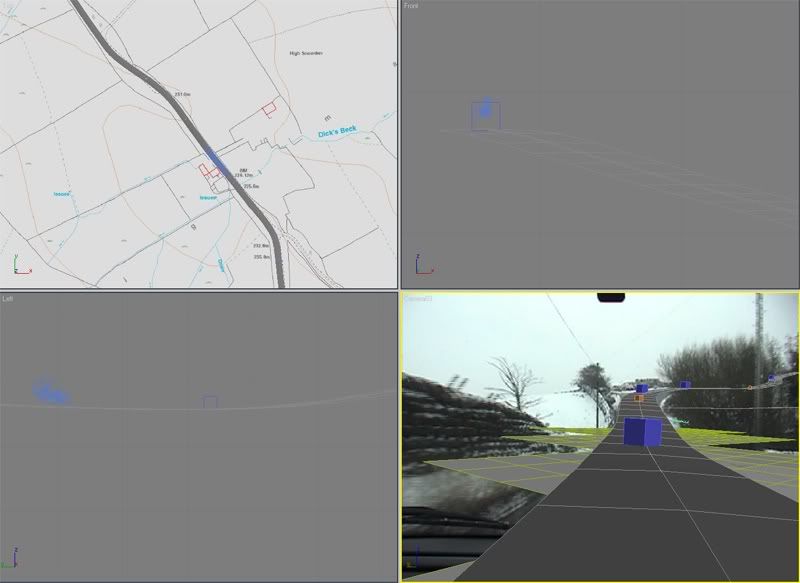
Still working at it slowly but surely

Managed to record some video, but unfortunately on a day that it snowed.
Tying it all together now with about 10 layers of mapping, contours, spot heights... complete nightmare of a project.
Managed to get about half way along now, slowly tracking the video and viewport camera to tie in, then fine adjusting the road.
Kinda wish I had a super accurate GPS device that I could use to make 3 lines, nearside, centre, and opposing line nearside, so I'd have camber, road crown and height/layout all in one
Anyone driven this road recently? Some contractors for a gas pipe have ripped alot of land up and put mud all over the place, especially round the blind bends. Worth watching out for and what looks like soft clay on the road usually has sandstone rocks in it, as a friends tyre/wheel found out!
Dave
Gassing Station | Yorkshire | Top of Page | What's New | My Stuff