Birmingham to London
Discussion


It'd need a bit of a swerve east to begin with, but I've done this route from Rugby to London several times and it's a lovely one.

Also interested if someone wants to do something next year.
My brother is in Kingswindford and parents in law Church Stretton.
Wife also thinks I am mad thinking about cycling up (or down), I did tell her she could drive and I would see her there!
Best thing is to fix a date next year and make a plan!
My brother is in Kingswindford and parents in law Church Stretton.
Wife also thinks I am mad thinking about cycling up (or down), I did tell her she could drive and I would see her there!
Best thing is to fix a date next year and make a plan!
Gruffy said:
It'd need a bit of a swerve east to begin with, but I've done this route from Rugby to London several times and it's a lovely one.
Thanks Gruffy. That looks interesting. Would you know how I might be able to navigate the route, i use a fenix3 but never the navigation and on the front of my bike i have attached a Samsung S4 which is mainly used for average speed. I thought i might be able to use it (using google maps) to navigate my way down.AndStilliRise said:
Thanks Gruffy. That looks interesting. Would you know how I might be able to navigate the route, i use a fenix3 but never the navigation and on the front of my bike i have attached a Samsung S4 which is mainly used for average speed. I thought i might be able to use it (using google maps) to navigate my way down.
Either go "old skool" and print it out or get a "garmin or something" and upload it to your handlebars!Black can man said:
The Cambridge to London run we did a few years ago was a great day I felt
We really should try & organise something similar in the New Year
I think Birmingham to London with a scenic route would be ideal
I'd be up for that!We really should try & organise something similar in the New Year
I think Birmingham to London with a scenic route would be ideal
AndStilliRise said:
Gruffy said:
It'd need a bit of a swerve east to begin with, but I've done this route from Rugby to London several times and it's a lovely one.
Thanks Gruffy. That looks interesting. Would you know how I might be able to navigate the route, i use a fenix3 but never the navigation and on the front of my bike i have attached a Samsung S4 which is mainly used for average speed. I thought i might be able to use it (using google maps) to navigate my way down.I had same issue recently and used Strava maps on my phone
I found the route I wanted on RidewithGPS and had it up on one monitor and then plotted it on my other screen on Strava, I then opened the free strava app and loaded the route on the phone
As gruff said buy a USB batter pack or second battery if you can
I found the route I wanted on RidewithGPS and had it up on one monitor and then plotted it on my other screen on Strava, I then opened the free strava app and loaded the route on the phone
As gruff said buy a USB batter pack or second battery if you can
stripy7 said:
I tried running this a couple of weeks back, my route was s t and dangerous though with fast A roads, bombed out after 70 miles.
Ah ok, is there anyway you could show us on a map, so i can avoid such roads please?t and dangerous though with fast A roads, bombed out after 70 miles.FYI, I did London to Aylesbury return on Sunday which is mostly on the A41, a dual carriageway but does have a cycle lane. Still doesn't stop people from wanting to side swipe me.
If you don't have nav, I'd plot the route with the least possible fk-ups. From Brum, head towards Solihull, then across to Warwick, then follow the road past Gaydon to Banbury. Down to Aynho, then Bicester, and then you can follow the A41 all the way home, give or take. Probably not the most scenic or traffic-free route but it'll get you home.
k-ups. From Brum, head towards Solihull, then across to Warwick, then follow the road past Gaydon to Banbury. Down to Aynho, then Bicester, and then you can follow the A41 all the way home, give or take. Probably not the most scenic or traffic-free route but it'll get you home.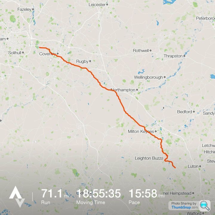
Thanks
How about something like this? Not sure whether the roads will be bike friendly though?
https://www.google.co.uk/maps/dir/b73+6uq/51.81436...
How about something like this? Not sure whether the roads will be bike friendly though?
https://www.google.co.uk/maps/dir/b73+6uq/51.81436...
if you create the "Ride" in Strava and tick "Use Popularity" it will generally take you away from "dangerous/unpleasant" roads as it uses the "heatmap" data to plot the route, plus you can zoom in as much as you like.
So if you used that for Stripy7 route from "Meridian?" to "Slapton?" then it would drop you south Leamington and then south east through silverstone, stoney stratford, waddon and wing!
So if you used that for Stripy7 route from "Meridian?" to "Slapton?" then it would drop you south Leamington and then south east through silverstone, stoney stratford, waddon and wing!
https://www.strava.com/routes/7149900
Right i need to sort my watch out (Fenix3) with base maps and this as a course. This is all starting to get a little real now, gulp!
Regards, ASIR.
Right i need to sort my watch out (Fenix3) with base maps and this as a course. This is all starting to get a little real now, gulp!
Regards, ASIR.
Marcellus said:
if you create the "Ride" in Strava and tick "Use Popularity" it will generally take you away from "dangerous/unpleasant" roads as it uses the "heatmap" data to plot the route, plus you can zoom in as much as you like.
So if you used that for Stripy7 route from "Meridian?" to "Slapton?" then it would drop you south Leamington and then south east through silverstone, stoney stratford, waddon and wing!
Yeah, but its definition of a "road" can be somewhat variable. Often I've found it taking me down pointless rabbit-hole cycle paths and over foot bridges when you get into town.So if you used that for Stripy7 route from "Meridian?" to "Slapton?" then it would drop you south Leamington and then south east through silverstone, stoney stratford, waddon and wing!
I'd say that route ASIR plotted looks pretty decent. A41 out of Brum doesn't look too taxing, and the rest of it keeps away from the main roads. Should be a nice ride.
AndStilliRise said:
https://www.strava.com/routes/7149900
Right i need to sort my watch out (Fenix3) with base maps and this as a course. This is all starting to get a little real now, gulp!
Regards, ASIR.
I'm only familiar with the Coleshill to Warwick section and they are all roads I'd be happy to cycle on/have cycled on.Right i need to sort my watch out (Fenix3) with base maps and this as a course. This is all starting to get a little real now, gulp!
Regards, ASIR.
Gassing Station | Pedal Powered | Top of Page | What's New | My Stuff