Salisbury plain
Discussion


Crossflow Kid said:
For info (from TreadLightly.org):
MoD are asking/telling people not to use SPTA for recreation until further notice due to flooding/saturation.
And for those not in the US... ;-)MoD are asking/telling people not to use SPTA for recreation until further notice due to flooding/saturation.
http://www.treadlightly-uk.org/
And those who follow on Twitter:
"DIO @mod_dio 3h
Please do not come to Salisbury Plain for recreational purposes until further notice. There's serious flooding inc. villages. #modontheplain"
One of the Jeep clubs i'm with went down there last weekend. But due to the flooding, they wisely chose to cut the day short and not contribute to tearing the lanes up further.
Crossflow Kid said:
For info (from TreadLightly.org):
MoD are asking/telling people not to use SPTA for recreation until further notice due to flooding/saturation.
Thank you for posting - you beat me to it!MoD are asking/telling people not to use SPTA for recreation until further notice due to flooding/saturation.
Full press release below:
[b]TreadLightly-UK
The MOD on Salisbury Plain have asked us to put this out: [/b]
“Rivers are in flood, the ground saturated & many springs that have not run for years are now active. A number of villages on Salisbury Plain are now flooded e.g. Chitterne, Netheravon and Tilshead.
Please do not come to the Plain for recreational purposes until further notice.
Seek out sustainable lanes during this exceptional wet period that we are experiencing. Please share with as many groups and forums as possible. Many thanks
Crossflow Kid said:
K50 DEL said:
I had exactly the same thing when I was trying to ascertain where and where not to go a couple of years ago... I gave up in the end
Can't say I'm altogether surprised if this is your idea of a good day's laning: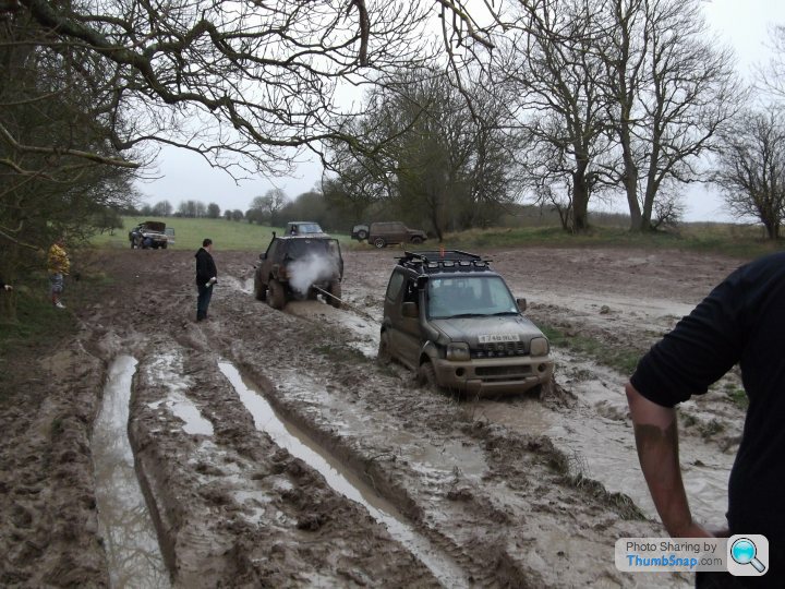
100SRV hits the nail squarely on the head:
100SRV said:
As far as I am concerned there are NO CLIQUES - as long as you demonstrate that you can be responsible when using green lanes all are welcome.
For the record:
For the record:
- I am happy to take those new to green laning on a trip.
- I am very wary about sharing information concerning viable routes because, in my experience, if you suggest a route is avoided when wet it will get over-used by those who think their cars are hippos.
Edited by Crossflow Kid on Tuesday 7th January 15:28
That "is" a Byway...
Its here, Centre Map
https://www.google.co.uk/maps?ll=51.199711,-1.9786...
Edited by JVaughan on Wednesday 22 January 17:59
so the MOD ask everyone to stay away from the flooding etc etc however, Surrey & Hampshire Offroad Club seem to think they are above that? http://www.youtube.com/watch?v=-SlpJ8GfRdE...While their website asks people to adhere to the Salisbury plain and green laning code of conduct............ Nice one guys 
TLandCruiser said:
so the MOD ask everyone to stay away from the flooding etc etc however, Surrey & Hampshire Offroad Club seem to think they are above that? http://www.youtube.com/watch?v=-SlpJ8GfRdE...While their website asks people to adhere to the Salisbury plain and green laning code of conduct............ Nice one guys
The video was filmed 13th dec though so before the ban?

Crossflow Kid said:
JVaughan said:
That "is" a Byway...
No it "is" not. The byway is further to the East.But you keep kidding yourself Treacle.........and using Google maps as a Definitive Map.
http://www.wiltshire.gov.uk/communityandliving/rig...
M
camel_landy said:
Curiouser and curiouser.It seems on the 50000 the byway is marked as further East, yet the overlay goes further West through the children's mudpit.
Hardly helpful.
Anyhow, legalities aside, it's still trashing a lane.
ETA: it's ok though, everyone does it.
Edited by anonymous-user on Wednesday 29th January 17:54
Crossflow Kid said:
JVaughan said:
That "is" a Byway...
No it "is" not. The byway is further to the East.But you keep kidding yourself Treacle.........and using Google maps as a Definitive Map.
Not that I need to justify myself to you in any way .. I use MultiMap on my Laptop with a GPS receiver.
I also regularly speak to DE Ops, Defense Estates, Land Warfare Centre in Warminster.
My Contact is Richard Brookes" is you want to double check.
They hold copies of Militarty maps at WestDown Camp and Warminster that is accessible to the Public by appointment.
I also carry hard copies (Landranger) with the byways marked and updated on there too.
You've made the classic mistake of thinking RoW across the plain are the remit of MoD.
They're not.
And as I pointed out in reply to Camel's post the overlay and the actual marked byway appear to differ on the WCC web page. The marked byway goes further East, whilst the route overlay goes through your little (don't) pay and play bit. But fair enough, it's there on the official website so please go ahead and keep getting stuck up to your diffs in mud. Leaves the decent routes for the rest of us grown ups anyway I guess so I shouldn't complain really.
By the way, I've got lots of maps too. And a GPS. And several friends called Richard too. And one called Dom. No Derek's though. Must fix that. I run MM on an iPad by the way. So much more refined than a clunky old laptop.
I'm not your mate though - sorry.
Edited by anonymous-user on Monday 3rd February 10:22
 Well "Sweetlips" (used in leu of the word "Mate") .. The reason I use "Defense Estates" as my source of information is because whilst Byways are managed by Wilts Council, the MOD have the power to close the Byways that I use (Larkhill, Westdown & Bulford).
As the Byways are all signposted now on the Plain (with the exception of parts of the "old Marlborough Road" at SPTA East), I have no problem with using these signposted routes "Unless" they have been closed by the MOD for operational reasons... Hence why the first port of call is always the MOD Estates... or indeed MODPOL at Larkhill if you just want to check at short notice (like when the Flags are due to be lowered to allow access, or when using the Byways at night to make sure people know were on the Training area)

As for using a Laptop Vs iPad or having friends called "Derek" ... how petty.. Grow up !
Edited by JVaughan on Monday 3rd February 10:38
im sweety sorry for the poor spelling... bloody small iPhone Keypad & fat fingers.
As for "Free" Pay & Play.. if a route is challenging or there is ambiguity as to the exact route of the Right of Way "and" there is a particular muddy section that is part of that ambiguity ... then that is up to the individual driver to select his / her route .. even if that choice is a poor one.


As for "Free" Pay & Play.. if a route is challenging or there is ambiguity as to the exact route of the Right of Way "and" there is a particular muddy section that is part of that ambiguity ... then that is up to the individual driver to select his / her route .. even if that choice is a poor one.
Crossflow Kid said:
Oh, I thought you were the expert in all things SPTA and so would know exactly where any routes go beyond any ambiguity, mud or not?
Guess I was wrong and you don't know it all. I shall bear that in mind next time you're dispensing advice on where or where not to go.
Haha .. Have Never professed to be an "expert", as much as your not one either.Guess I was wrong and you don't know it all. I shall bear that in mind next time you're dispensing advice on where or where not to go.
You do however flatter me with your perception of me... it is obviously far greater than my perception of you.
Bored of this now... have a nice day

JVaughn said:
You do however flatter me with your perception of me... it is obviously far greater than my perception of you.
Now that's not very nice, is it?And it's "you're" not "your"
Don't blame your iPHone. Grow up!
Or something.
Edited by anonymous-user on Monday 3rd February 12:29
Gassing Station | Off Road | Top of Page | What's New | My Stuff