The hiking gear and adventures thread...
Discussion


Snow and Rocks said:
I try not to take unnecessary stuff but my last trip out overnight involved splitting 30kg of coal between 3 of us so definitely not one who follows the ultralight ethos.
There was also a bottle of malt decanted into a plastic bottle which combined with the coal meant the cairngorm evenings were very pleasant indeed despite the weather outside!
Cairngorms? I was there last night with coal and some malt.There was also a bottle of malt decanted into a plastic bottle which combined with the coal meant the cairngorm evenings were very pleasant indeed despite the weather outside!
Another not in lightweight camp. In fact I have recently started carrying a seperate mini non stick frying pan. Just big enough to fit two bits of square sausage for my rolls.
The Lixada Collapsible Nonstick Pan. £16 on Amazon. Highly recommended.
I’ve been suckered into the whole gravel bike packing “scene” so my tent is a bike packing specific version - which essentially means is just has poles in shorter sections to fit between the bars.
As to trail running vests. I use a Salomon 12 adv skin which is easily enough for a day, lots of pockets for gels and the like, even a bin pocket, holder for poles, bladder as well as squeezy bottles and the main compartment for waterproofs, first aid, GoPro, whatever.
As to trail running vests. I use a Salomon 12 adv skin which is easily enough for a day, lots of pockets for gels and the like, even a bin pocket, holder for poles, bladder as well as squeezy bottles and the main compartment for waterproofs, first aid, GoPro, whatever.
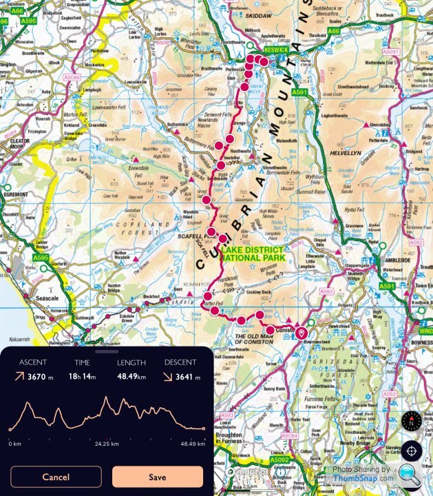

I've had a play in at what I think that route is in MemoryMap:
Coniston to Keswick via the Great Moss
I've also done a version which stays higher and crosses to Scafell via Crinkle Crags instead:
Coniston to Keswick via Crinkle Crags and Bow Fell
Both big trips!
Coniston to Keswick via the Great Moss
I've also done a version which stays higher and crosses to Scafell via Crinkle Crags instead:
Coniston to Keswick via Crinkle Crags and Bow Fell
Both big trips!
giveitfish said:
I've had a play in at what I think that route is in MemoryMap:
Coniston to Keswick via the Great Moss
I've also done a version which stays higher and crosses to Scafell via Crinkle Crags instead:
Coniston to Keswick via Crinkle Crags and Bow Fell
Both big trips!
Thank you so much! I'll get them loaded into my OS Maps.Coniston to Keswick via the Great Moss
I've also done a version which stays higher and crosses to Scafell via Crinkle Crags instead:
Coniston to Keswick via Crinkle Crags and Bow Fell
Both big trips!
On a separate note, I am off wild camping tonight. I can't wait any longer for the weather to be half decent.
MonkeyBusiness said:
giveitfish said:
I've had a play in at what I think that route is in MemoryMap:
Coniston to Keswick via the Great Moss
I've also done a version which stays higher and crosses to Scafell via Crinkle Crags instead:
Coniston to Keswick via Crinkle Crags and Bow Fell
Both big trips!
Thank you so much! I'll get them loaded into my OS Maps.Coniston to Keswick via the Great Moss
I've also done a version which stays higher and crosses to Scafell via Crinkle Crags instead:
Coniston to Keswick via Crinkle Crags and Bow Fell
Both big trips!
On a separate note, I am off wild camping tonight. I can't wait any longer for the weather to be half decent.
ben5575 said:
I know I could plot that on a map but do you have a gpx for that, or a link to it on is maps for ease pls? That has the makings of an excellent lads weekend away.
Not sure I’d be able to cart 30kg of coal over that mind!
I don’t think I have it saved sorry… done it too many times to need it now and just penned it for this post. That said like me it would just take you 5 mins on the premium OS map online to make it as the paths snap to route when you join the cursors as I expect you know . Very easy. Can then download to your gps to device Beware to check routes up the specific fells so you know what to expect though. It’s not a perfect tool. Also check other peoples ideas. That one I post has no issues although just for example it comes off Scafell on the back corridor route. .. it’s easy but not as easy as the easiest should that matter .. but note I’ve seen snapped routes up scrambles which for the unaware can be a bit much with a monster bag and a fear of heights. Not sure I’d be able to cart 30kg of coal over that mind!
Just to add. One local fella has provided me some ideas when I can’t be bothered to plan and the kids just need a run out for the day. A bloke called Andrew. His website is https://www.andrewswalks.co.uk/ and it’s good as he has a decent camera by looks of it. Nice to get some ideas and he provides links to his routes are made so you can get them from the online OS map
Following our aborted Andorra adventure from last summer (a couple of pages back) my dopey mate and me are at it again - we have just booked our flights to Bodo, Norway, for the beginning of July, where we'll be getting a ferry to the southern tip of the Lofoten Islands to do the "Long Crossing" - a 100 mile traipse up to the North islands.
Given ourselves 10 days, but can cut it shorter or do some extra day-trips depending on the pace we manage.
Will be wild camping as much as possible, but may treat ourselves to a campsite or some other paid accommodation once or twice to use a shower etc - to be investigated.
A lovely relaxing Harmen Hoek video of it:
https://www.youtube.com/watch?v=_7PGZoFFnck&t=...
Anyone here done it? I may have some questions for you...
That looks amazing! There's some incredible places to go in this world isn't there...
Make sure you read The Hike on the plane over (bubble gum thriller set in the Norwegian wilderness): https://www.amazon.co.uk/Hike-gripping-twisty-thri...
Make sure you read The Hike on the plane over (bubble gum thriller set in the Norwegian wilderness): https://www.amazon.co.uk/Hike-gripping-twisty-thri...
Loften does look spectacular... I really must get a passport and some finance sorted and start exploring some of these places rather than 'just' hiking in the UK.
Mind you, I don't help myself when I keep buying loads of kit: got a good deal on a Fjallraven Kaipak jacket the other day: it's just arrived and I love it (wearing it as I type this ).
).
I've been doing a lot of hiking in the peaks recently... bit of training for the Pennine Way. But as the weather is so damp at the moment I've put the PW on hold for a bit. Getting soaked occasionally when on a multi day hike is one thing, but when it's just constant rain and all your kit is damp or soaked, it's not just that much fun. I'll see what the weather is doing in May and make a decision.
Weather does look ok (ish) for the weekend, so another 18 mile or so day hike is in order.
Knee report for Bill: all is well at the moment!
Mind you, I don't help myself when I keep buying loads of kit: got a good deal on a Fjallraven Kaipak jacket the other day: it's just arrived and I love it (wearing it as I type this
).I've been doing a lot of hiking in the peaks recently... bit of training for the Pennine Way. But as the weather is so damp at the moment I've put the PW on hold for a bit. Getting soaked occasionally when on a multi day hike is one thing, but when it's just constant rain and all your kit is damp or soaked, it's not just that much fun. I'll see what the weather is doing in May and make a decision.
Weather does look ok (ish) for the weekend, so another 18 mile or so day hike is in order.
Knee report for Bill: all is well at the moment!
Has anyone here gone up both the Snowdon Ranger path and Ben Nevis (tourist) mountain path?
I went up Snowdon earlier in the week and am looking to go up Ben Nevis next and was wondering how the two compare. I'm aware that Ben Nevis is over twice the distance. Any tips would be much appreciated. Thanks all.
I went up Snowdon earlier in the week and am looking to go up Ben Nevis next and was wondering how the two compare. I'm aware that Ben Nevis is over twice the distance. Any tips would be much appreciated. Thanks all.
TheThing said:
Has anyone here gone up both the Snowdon Ranger path and Ben Nevis (tourist) mountain path?
I went up Snowdon earlier in the week and am looking to go up Ben Nevis next and was wondering how the two compare. I'm aware that Ben Nevis is over twice the distance. Any tips would be much appreciated. Thanks all.
I think it'd be fair to say that they are similar in nature, but as you say the Ben Nevis path is longer. They're both "motorways" ... easy enough to navigate so long as visibility is OK, pretty good surface to walk on, not "technical". Ben Nevis's weather conditions are potentially more of an issue. It can be t-shirt Spring weather at the bottom and sub-zero fog with packed snow on the ground at the top. You should always be prepared to deal with a rapid change to sI went up Snowdon earlier in the week and am looking to go up Ben Nevis next and was wondering how the two compare. I'm aware that Ben Nevis is over twice the distance. Any tips would be much appreciated. Thanks all.
 t weather on Snowdon, but you need to be doubly prepared on Ben Nevis. Just do the basics and you'll be fine; carry waterproofs and spare warm clothes, let someone know where you're planning to go and when you expect to be back, carry a whistle, take a map and compass and familiarise yourself with them even if you're going to use a phone to navigate, and you can always turn back and try it another day if conditions start to look properly dodgy or you're falling way behind schedule.
Thank you both for the replies. The Ranger path is the least used path out of all of them as far as I can tell. The scenery was stunning though. Summit conditions were pretty bad too be fair but it was my first mountain and I learned some valuable lessons.
Are there any shear drops from the path on Ben Nevis and does the path get very narrow at any point? I'm just trying to do as much research as I can before we go and would like to here from people that have actually been up there.
Are there any shear drops from the path on Ben Nevis and does the path get very narrow at any point? I'm just trying to do as much research as I can before we go and would like to here from people that have actually been up there.
Gassing Station | Holidays & Travel | Top of Page | What's New | My Stuff