World War Two: Evidence of damage/stuff left over now.
Discussion


wildcat45 said:
I was looking at that a few months ago. It is quite sobering isn't it?

Growing up in a relatively unaffected area it past me by as a kid, it wasn't until I moved near the docks in London that it hit home. A work colleague lived in Canning Town, one day I asked her why her house and the one next door were different in appearance to the rest of the street. Apparently they were built in the 50's to replace the original ones that were destroyed in the Blitz. As soon as you notice it in one street you start to see it all over the East End.
Along the length of the Kennet and Avon canal in there are pillboxes from this:
http://www.independent.co.uk/life-style/the-second...
There are loads of them, very interesting. Having had a look around a few of them, they will be here for a thousand years.
http://www.independent.co.uk/life-style/the-second...
There are loads of them, very interesting. Having had a look around a few of them, they will be here for a thousand years.
There's quite a few things around here built for the D-Day landings.
Near Mawnan Smith there's still a conrete road across a field which used for loading vehicles onto craft at a nearby beach, this beach still has concrete over a great part also for the above.
The road down to The Smugglers Inn at Tolverne is 3 lanes wide built again for the tanks (this is where General Eisenhower visited).
Not to mention many pill boxes still in the area and defences both side of the River Fal.
There's a gap in some terraced houses in town where one was bombed in the war, only recently has a road been put through the gap for a new build behind.
I grew up at Upton Towans near Hayle and the towans area was a massive dynamite factory during WW2. Our house is about 1/3 of a mile from the entrance to the towans and I remember my gran telling me about the windows getting blown out when there had been accidents at the factory.
Unfortunately, these are just photos I could find on google as I'm at work. A friend of my Gran's was very into the history of the dynamite works and some of the pictures he's managed to dig up are brilliant, but I've lost touch with him.
This was when it was producing explosives. Odd to see it like that now as that I where I often take the dogs and used to ride my bike there. That bit is also brilliant for sliding down when it's been snowing.

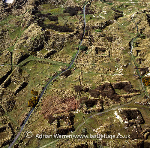
This is a good view of the towans as it shows the squares, which I think were storage bunkers for the explosives and materials. Or for parties, when I was a teenager.
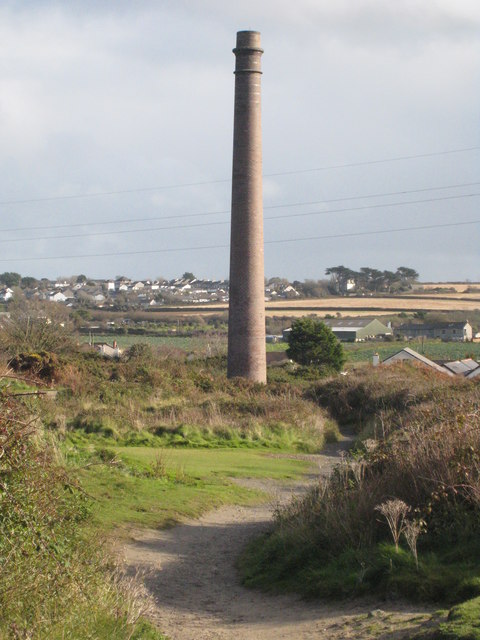
The stack at the entrance to the towans, visible for quite a distance.
One of the few remaining buildings. This one overlooks the sea, I'd love to be able to convert it into a cabin, but it's a protected area now.

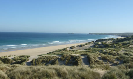
I haven't seen them for a while, but during the war the beach was covered with wooden posts to prevent planes landing. I remember some still being there when I was a kid. I used to be a bit careful about coming off my board when I surfed there.
Unfortunately, these are just photos I could find on google as I'm at work. A friend of my Gran's was very into the history of the dynamite works and some of the pictures he's managed to dig up are brilliant, but I've lost touch with him.
This was when it was producing explosives. Odd to see it like that now as that I where I often take the dogs and used to ride my bike there. That bit is also brilliant for sliding down when it's been snowing.
This is a good view of the towans as it shows the squares, which I think were storage bunkers for the explosives and materials. Or for parties, when I was a teenager.
The stack at the entrance to the towans, visible for quite a distance.
One of the few remaining buildings. This one overlooks the sea, I'd love to be able to convert it into a cabin, but it's a protected area now.
I haven't seen them for a while, but during the war the beach was covered with wooden posts to prevent planes landing. I remember some still being there when I was a kid. I used to be a bit careful about coming off my board when I surfed there.
Tickle said:
I was told that the holes in this bridge in Liverpool were produced by a Messerschmitt in WWII, not sure how true this is
https://www.google.co.uk/maps/@53.4256843,-2.98927...
Definitely not a Messerchmitt, those fokkers didn't have the range to reach merseyside.https://www.google.co.uk/maps/@53.4256843,-2.98927...
Gargamel said:
All along the North Downs from Box Hill to Farnham are a numerous WW2 pill boxes - most of which are open.
We have oodles of 'em here in East Sussex too - originally the powers that be planned that the River Medway would be a line of defence and thus they built loads, with extra ones if there was a railway line nearby (usually with a bigger aperture for an anti-tank gun or field artillery type thingy.Have a look for book called 'Defence of the Realm' which details all sorts of features from Napoleonic times to the Cold War (I picked up a copy at Duxford).
Down on the beach at Cuckmere Haven you can make out the gun emplacements facing the open Channel and potential invaders, made of earth embankments. If we pop over to walk there soon I'll take the camera.
Less obvious - but very interesting - was Monty's wartime HQ underneath some nice villas on the south side of Tunbridge Wells. Nearby was a separate tunnel network the proposed use of which has never been explained;
http://www.courier.co.uk/mystery-lies-underneath-f...
Amazing what Google Earth shows.
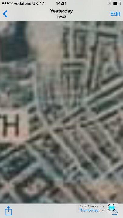
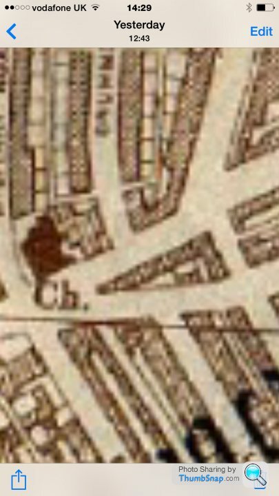
Here is a fuzzy crop from a Luftwaffe target map of North Shields.
Note the triangular set of buildings.
The next image is the location on a map that I found on line which marks where the bombs fell. That's the red dot on the left. See the triangular set of buildings there.
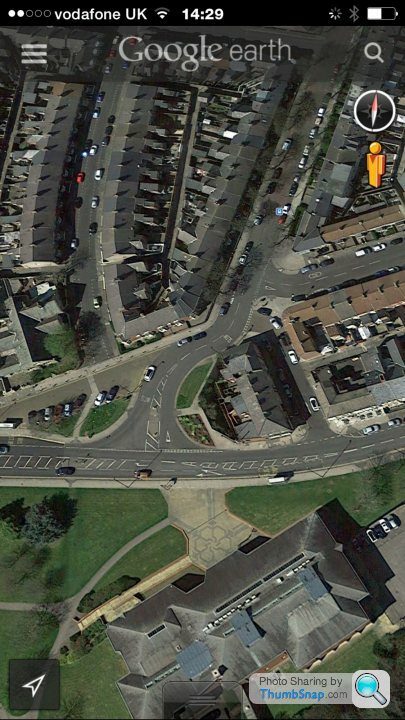
One of the buildings that was destroyed was made of glazed bricks. You can still see them inside the hoarding that you can see in the middle right of this Google Earth image. They are all pock marked with shrapnel.
That bomb took out a whole block. They never bothered rebuilding as you can see.
Here is a fuzzy crop from a Luftwaffe target map of North Shields.
Note the triangular set of buildings.
The next image is the location on a map that I found on line which marks where the bombs fell. That's the red dot on the left. See the triangular set of buildings there.
One of the buildings that was destroyed was made of glazed bricks. You can still see them inside the hoarding that you can see in the middle right of this Google Earth image. They are all pock marked with shrapnel.
That bomb took out a whole block. They never bothered rebuilding as you can see.
Edited by wildcat45 on Friday 11th September 14:44
I did my undergraduate degree at Liverpool in the late 80's / early 90's, and on the terraced houses where I rented a house, all the houses still had stubs of railings in the stone caps of the low brick walls outside them, from where the railings were cut off during the war for the metal.
moorx said:
There are a couple of WW2-related facts/photos in amongst this:
http://www.bristol-culture.com/2014/08/08/18-thing...
(I'm Bristolian by birth).
This is also interesting - includes Bristol, but also other buildings worldwide:
http://weburbanist.com/2009/10/25/war-and-pieces-9...
If talking Bristol ...On foot through Southville you can track where a stick of bombs fell, not missing the harbour by much - from the top of Upper Perry Hill across to Greville Street.... evidence easy to spot a few later '40's houses nestled in Victorian Terraces....with surrounding houses having shrapnel damage....http://www.bristol-culture.com/2014/08/08/18-thing...
(I'm Bristolian by birth).
This is also interesting - includes Bristol, but also other buildings worldwide:
http://weburbanist.com/2009/10/25/war-and-pieces-9...
Walk around the middle of Coutances in Northern France, which saw massively heavy fighting in WWII, and there are bullet holes everywhere. The Mairie and Cathedral are both covered in them. (I couldn't find a close up pic, so here's the Mairie anyway, if you pixel peep you might be able to see something).

In the garden of my Mum's house there's an air raid shelter (in Sussex) which you can just about see in this pic (Google Street View crop). It's a concrete box sunk a few feet into the garden, the roof and walls are about a foot thick and you walk down 3 or 4 steps to get into it. I imagine it would make a handy tomb in the event of a direct hit but would provide decent protection in other circumstances.
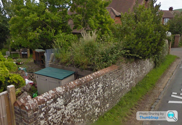
In the garden of my Mum's house there's an air raid shelter (in Sussex) which you can just about see in this pic (Google Street View crop). It's a concrete box sunk a few feet into the garden, the roof and walls are about a foot thick and you walk down 3 or 4 steps to get into it. I imagine it would make a handy tomb in the event of a direct hit but would provide decent protection in other circumstances.
I was working with an American in the London docklands, he was planning to drill some boreholes, I said you are checking for unexploded bombs aren't you? He said this area wasn't bombed. When I stopped laughing, I took him to the entrance of the site and showed him the memorial to the people killed in a factory which took a direct hit right where he was planning to start work. Can't remember the exact location.
I believe you can still look around the Air Raid Shelters under Stockport - I've not got around to going to look myself yet despite working in Stockport and not living that far away.
http://www.stockport.gov.uk/services/leisurecultur...
http://www.stockport.gov.uk/services/leisurecultur...
There's a pill-box by Devil's Bridge on the A65 at Kirky Lonsdale in North Yorkshire.
I always think that if they'd got that far, it was game over really.
http://www.users.globalnet.co.uk/~rwbarnes/defence...
I always think that if they'd got that far, it was game over really.
http://www.users.globalnet.co.uk/~rwbarnes/defence...
Just South of Audley End Station theres a large viaduct (9 spans I think) that was a target during WW2 as its the only one on the line and a weak point. The line was used at night to bring tanks and ammunition from Norwich. One time it was attacked by a ME109 that dropped its bomb and missed and then tried to shoot it up. There is a big group of bullet holes in the brickwork still. The bomb hole was visible next to the river until about 1980 when it was infilled.
I knew a chap called Ernie who was working on the viaduct at the time and told me he heard the aircraft first and sounded the alarm he and his mates 'ran like hell up the 'up' line'. He lived the rest of his life a cottage next to the viaduct. On another occasion a bomb dropped on the station hit the ground under the entrance arch (below) at an angle and bounced back in the air before exploding.
I knew a chap called Ernie who was working on the viaduct at the time and told me he heard the aircraft first and sounded the alarm he and his mates 'ran like hell up the 'up' line'. He lived the rest of his life a cottage next to the viaduct. On another occasion a bomb dropped on the station hit the ground under the entrance arch (below) at an angle and bounced back in the air before exploding.
Edited by V6Pushfit on Friday 11th September 17:02
Fascinating stuff.
I think I picked this link up on here with lots of 'then and now' pictures from WWII. Very thought provoking.
http://www.faehrtensucher.net/#!then-and-now/c18y8
I also selectively purchase 'After the Battle' magazine which again shows lots of comparative photos and have several of their excellent books.
https://www.afterthebattle.com/index.html
Try 'Panzers in Normandy - Then and Now' by Eric Lefevre, many of the villages you drive through saw some incredible damage yet not realised from a cursory glance.
Alpacaman said:
I was working with an American in the London docklands, he was planning to drill some boreholes, I said you are checking for unexploded bombs aren't you? He said this area wasn't bombed. When I stopped laughing, I took him to the entrance of the site and showed him the memorial to the people killed in a factory which took a direct hit right where he was planning to start work. Can't remember the exact location.
Anyone with half a brain would have an unexploded ordinance survey carried out if you're digging any reasonable depth in London.Near Aberlady in East Lothian you can still see a row of large concrete blocks which formed an anti-tank 'fence', as Aberlady Bay was considered a prime insertion point for a German land invasion. That nearby Gosford House was used as a barracks and POW camp might have had something to do with it too.
http://goo.gl/maps/CU4YH
http://goo.gl/maps/CU4YH
Gassing Station | The Lounge | Top of Page | What's New | My Stuff