World War Two: Evidence of damage/stuff left over now.
Discussion


Bluedot said:
Strangely enough, the BBC has a story today about unexploded WWII bombs still around:
http://www.bbc.com/future/story/20150922-these-naz...
I enjoyed that nice article. http://www.bbc.com/future/story/20150922-these-naz...
Bombs are something I could never really get my head around as a kid. Born in the late 70's it all seemed regular to hear about them on the news, with all the IRA stuff. I've been in a couple of bomb scares also.
Them when the IRA bomb in Manchester went off, I had the attitude it was just another bomb gone off. How wrong was I ! That all changed when my Grandparents said there house windows were shaking when it went off, they lived miles from the city centre
 Then when I actually saw what damage was done I couldn't believe it.
 Anyway back to the article. Why the hell would anyone choose to do a job of defusing bombs !!!! Hats off to those crazy people, must be on a par with the bravery of the people who fought in the Wars


theshrew said:
Although I find this type of thing quite interesting. How the hell did they come to that conclusion ?
First bombs were hand dropped.http://www.dover-kent.co.uk/history/ww1c_bombing.h...
Dr Jekyll said:
Up until around 2000 the lower end of Tottenham Court road had a row of small temporary looking shops on the Western side. All single storey I think and looking very out of place. They were replacements for bombed buildings and you could see the shapes of the roofs of the vanished buildings on the walls of higher buildings behind.
I remember when these were finally demolished; they were thrown up quickly and cheaply on the bombsites, so when they came down you could see that the basements and the back parts (and some fittings) of the ground floors of the original buildings were still there as the new stuff didn't fill the site and they hadn't bothered to clear the site properly. I think the original flooring was mostly there too with holes in places? wildcat45 said:
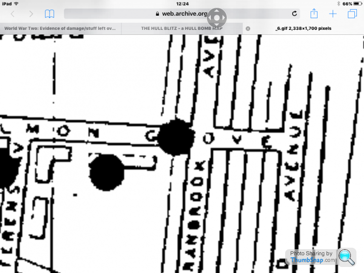
Still can't believe I lived there for three years and didn't know about this. Sadly the map on the link requires me to download some software which I can't do. I lived in Cranbrook Avenue and Grafton Street. Without seeing the map, I guess the Grafton pub site was a former bomb site, and perhaps the petrol station at the Beverly Road end?
Here is an older static image version on the internet archive, you want map 6 and yes it look like both the Grafton Pub and the Chapel opposite were built on bomb sites, but not the petrol station.https://web.archive.org/web/20140403010309/http://...
fatboy18 said:
A very good film was made about it called operation daybreak
Not sure why but your other pics did not come out?
I've spaced them out now and deleted the URL rubbish
https://www.youtube.com/watch?v=v5YVAqwC5UU
Not sure why but your other pics did not come out?
I've spaced them out now and deleted the URL rubbish
https://www.youtube.com/watch?v=v5YVAqwC5UU

I know it's obvious but it's pillboxes for me!
Growing up in South West England I remember regularly seeing them along the coast which always seemed obvious, now I live in Berkshire where they're somewhat less common however walking along the Kennet and Avon Canal I saw this which reminded me how important waterways were in WW2.

Growing up in South West England I remember regularly seeing them along the coast which always seemed obvious, now I live in Berkshire where they're somewhat less common however walking along the Kennet and Avon Canal I saw this which reminded me how important waterways were in WW2.
Martin4x4 said:
Here is an older static image version on the internet archive, you want map 6 and yes it look like both the Grafton Pub and the Chapel opposite were built on bomb sites, but not the petrol station.
https://web.archive.org/web/20140403010309/http://...
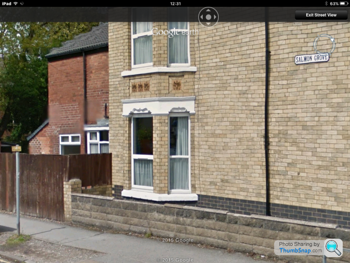
Thanks for that. Fascinating. It appears a bomb dropped right next to my old house on the junction of Salmin Grove and Cranbrook Avenue. https://web.archive.org/web/20140403010309/http://...
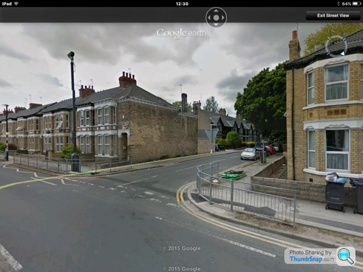
And you can see the damage today on Sreet View.
 n
n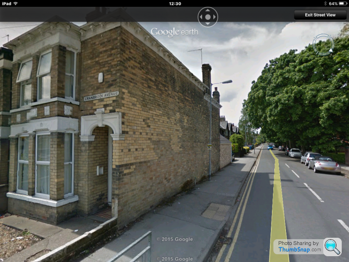
That's looking down Salmon Grove from Cranbrook. Maybe the surrounding buildings were badly damaged as there is no repair evidence suggesting whole new walls.
I'm also from Hull... apologies if this has already been posted but there's a Theatre down Beverley Road that was bombed in WWII and is still in it's ruined state.

Some information about Hull in the Blitz
Streetview
Some information about Hull in the Blitz
Streetview
Edited by The_Cheeseman on Thursday 24th September 14:42
During WW2 the local beach was used to embark British & Canadian troops prior to D-Day as well as build sections of mulberry harbour.
To facilitate this a 2 story control tower was built - its still in use as a sailing club
http://www.stokesbay-sc.co.uk/history.php
The club still displays some invasion stripes

To facilitate this a 2 story control tower was built - its still in use as a sailing club
http://www.stokesbay-sc.co.uk/history.php
The club still displays some invasion stripes
Sorry if it's already been covered, but there's the Taunton Stop Line nearby; maybe not quite as historic or exciting as other stuff posted here though!
https://www.google.co.uk/maps/@50.9973503,-2.98770...
(Bunker behind barn)
https://www.google.co.uk/maps/@50.9973503,-2.98770...
(Bunker behind barn)
MBBlat said:
During WW2 the local beach was used to embark British & Canadian troops prior to D-Day as well as build sections of mulberry harbour.
To facilitate this a 2 story control tower was built - its still in use as a sailing club
http://www.stokesbay-sc.co.uk/history.php
The club still displays some invasion stripes
Driven past it countless times and never knew!To facilitate this a 2 story control tower was built - its still in use as a sailing club
http://www.stokesbay-sc.co.uk/history.php
The club still displays some invasion stripes
Has anybody got any experiance or tips on tracing WW2 buildings? In my archery club, we have 2 ww2 buildings and what looks like a base for an mast of some sort, or atleast a tether for 1.
Recent ground works have uncovered what looks like the entrance to a tunnel, and we'd like to know what the area was used for before we go messing around any futher, for obvious reasons. Looking at the brick and stone work, its consistant with the other buildings that were in use / built in the area, and the 2 buildings mentioned above are prefab concrete. I have found empty .303 cases or part of cases around the woods and local rumours confirm that it was MOD occupied in the war.
We're also close to RAF Tempsford, a SOE station, and the local Manor house opposite was used as accomodation for agents and RAF flying out.
The buildings are safe to be in and arround, but the tunnel is the bit that concerns us, as there appears to be subsidance over the top, and we need to know if we'll have to get the area safety checked plus we're nosey!! The rumours are that the site was a fuel dump, which given the SOE links to the area, and the mast base, I don't believe. A dump wouldn't need a radio (I'd expect fixed comms), and this base must be 6 tons, so a big mast was attached, to big for a telephone line mast. A radio listening station would be consistant with the forces in the area, proximoty to Chicksands, Bletchley and London.
Celtic Dragon said:
Has anybody got any experiance or tips on tracing WW2 buildings? In my archery club, we have 2 ww2 buildings and what looks like a base for an mast of some sort, or atleast a tether for 1.
Recent ground works have uncovered what looks like the entrance to a tunnel, and we'd like to know what the area was used for before we go messing around any futher, for obvious reasons. Looking at the brick and stone work, its consistant with the other buildings that were in use / built in the area, and the 2 buildings mentioned above are prefab concrete. I have found empty .303 cases or part of cases around the woods and local rumours confirm that it was MOD occupied in the war.
We're also close to RAF Tempsford, a SOE station, and the local Manor house opposite was used as accomodation for agents and RAF flying out.
The buildings are safe to be in and arround, but the tunnel is the bit that concerns us, as there appears to be subsidance over the top, and we need to know if we'll have to get the area safety checked plus we're nosey!! The rumours are that the site was a fuel dump, which given the SOE links to the area, and the mast base, I don't believe. A dump wouldn't need a radio (I'd expect fixed comms), and this base must be 6 tons, so a big mast was attached, to big for a telephone line mast. A radio listening station would be consistant with the forces in the area, proximoty to Chicksands, Bletchley and London.
Could the base be the remains of a water tower? A lot of bases had them?Recent ground works have uncovered what looks like the entrance to a tunnel, and we'd like to know what the area was used for before we go messing around any futher, for obvious reasons. Looking at the brick and stone work, its consistant with the other buildings that were in use / built in the area, and the 2 buildings mentioned above are prefab concrete. I have found empty .303 cases or part of cases around the woods and local rumours confirm that it was MOD occupied in the war.
We're also close to RAF Tempsford, a SOE station, and the local Manor house opposite was used as accomodation for agents and RAF flying out.
The buildings are safe to be in and arround, but the tunnel is the bit that concerns us, as there appears to be subsidance over the top, and we need to know if we'll have to get the area safety checked plus we're nosey!! The rumours are that the site was a fuel dump, which given the SOE links to the area, and the mast base, I don't believe. A dump wouldn't need a radio (I'd expect fixed comms), and this base must be 6 tons, so a big mast was attached, to big for a telephone line mast. A radio listening station would be consistant with the forces in the area, proximoty to Chicksands, Bletchley and London.
First port of call in finding out more about the place would be finding out who owns it now. It may have deeds. You could try the MOD for info, maybe the local council or the Land Registry.
Celtic Dragon said:
Has anybody got any experiance or tips on tracing WW2 buildings? In my archery club, we have 2 ww2 buildings and what looks like a base for an mast of some sort, or atleast a tether for 1.
Recent ground works have uncovered what looks like the entrance to a tunnel, and we'd like to know what the area was used for before we go messing around any futher, for obvious reasons. Looking at the brick and stone work, its consistant with the other buildings that were in use / built in the area, and the 2 buildings mentioned above are prefab concrete. I have found empty .303 cases or part of cases around the woods and local rumours confirm that it was MOD occupied in the war.
We're also close to RAF Tempsford, a SOE station, and the local Manor house opposite was used as accomodation for agents and RAF flying out.
The buildings are safe to be in and arround, but the tunnel is the bit that concerns us, as there appears to be subsidance over the top, and we need to know if we'll have to get the area safety checked plus we're nosey!! The rumours are that the site was a fuel dump, which given the SOE links to the area, and the mast base, I don't believe. A dump wouldn't need a radio (I'd expect fixed comms), and this base must be 6 tons, so a big mast was attached, to big for a telephone line mast. A radio listening station would be consistant with the forces in the area, proximoty to Chicksands, Bletchley and London.
The Defence of Britain project may have information. The data is a available as a KMZ download, which can be opened and viewed in Google Earth.Recent ground works have uncovered what looks like the entrance to a tunnel, and we'd like to know what the area was used for before we go messing around any futher, for obvious reasons. Looking at the brick and stone work, its consistant with the other buildings that were in use / built in the area, and the 2 buildings mentioned above are prefab concrete. I have found empty .303 cases or part of cases around the woods and local rumours confirm that it was MOD occupied in the war.
We're also close to RAF Tempsford, a SOE station, and the local Manor house opposite was used as accomodation for agents and RAF flying out.
The buildings are safe to be in and arround, but the tunnel is the bit that concerns us, as there appears to be subsidance over the top, and we need to know if we'll have to get the area safety checked plus we're nosey!! The rumours are that the site was a fuel dump, which given the SOE links to the area, and the mast base, I don't believe. A dump wouldn't need a radio (I'd expect fixed comms), and this base must be 6 tons, so a big mast was attached, to big for a telephone line mast. A radio listening station would be consistant with the forces in the area, proximoty to Chicksands, Bletchley and London.
http://archaeologydataservice.ac.uk/archives/view/...
Gassing Station | The Lounge | Top of Page | What's New | My Stuff