The 2016 summer and thunder thread

The 2016 summer and thunder thread

Author
Discussion

Puggit

Original Poster:

48,512 posts

249 months

Monday 13th June 2016
quotequote all
Plenty more storms available this week with low pressure in charge but warm air nearby.

Weekend looking potentially hot, and then it could either stay summery, or might go wet again. Watch this space.

Puggit

Original Poster:

48,512 posts

249 months

Friday 17th June 2016
quotequote all
Some funnel clouds yesterday, pics taken from twitter:

Oxfordshire:


Reading:

Puggit

Original Poster:

48,512 posts

249 months

Friday 17th June 2016
quotequote all
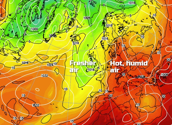
Looks like the Azores High is going to come and pay us a visit. This week's wet and thundery weather replaced by a little warmth.

Could start getting quite humid and thundery from the south later on next week.

Puggit

Original Poster:

48,512 posts

249 months

Tuesday 21st June 2016
quotequote all
Met Office yellow warning for potential thundery downpours in the SouthEast for Wed-Fri. Not sure I've seen a 3 day warning before!

http://www.metoffice.gov.uk/public/weather/warning...

Puggit

Original Poster:

48,512 posts

249 months

Tuesday 21st June 2016
quotequote all
neelyp said:
What's it looking like for the Assen TT this weekend?
First time at Moto GP so if you could arrange nice weather it would be much appreciated!
Low 20s and dry, mostly cloudy with some sunshine. Northerly wind though, hence the cloud coming off the North Sea - cool at night!

Could change, as it's only Tues.

Puggit

Original Poster:

48,512 posts

249 months

Wednesday 22nd June 2016
quotequote all
Mind out Kent!


Credit, as always to uksevereweather.com

Puggit

Original Poster:

48,512 posts

249 months

Wednesday 22nd June 2016
quotequote all
SilverSixer said:
Why are they using a pre-1974 counties map? Look at Berks/Oxon.
True - I think they forgot to close the Reading loop at the top!

Met office amber warning for Kent.


Puggit

Original Poster:

48,512 posts

249 months

Wednesday 22nd June 2016
quotequote all
maxdb said:
It's just misty here in Bexhill. I can't see it storming today frown
This is an overnight 'thing' - kick off is 8pm, with peak expected later during the early morning.

Further risk until Sat morning.

Puggit

Original Poster:

48,512 posts

249 months

Wednesday 22nd June 2016
quotequote all
Mr GrimNasty said:
Incoming, I can hear thunder, looks like a conveyor belt headed at the south east at the moment.
Lucky you - top far north in Berkshire frown

Puggit

Original Poster:

48,512 posts

249 months

Wednesday 22nd June 2016
quotequote all
Martin350 said:
Dark clouds bubbling up nicely to the south-ish of Maidstone, Kent right now.
Feels muggy enough for a good storm! smile
Something big about to wallop dungeness area

Puggit

Original Poster:

48,512 posts

249 months

Thursday 23rd June 2016
quotequote all
Yellow for the SE again today. Amber for inside the M25. Some very big storms over Cherboug and heading for us...

Puggit

Original Poster:

48,512 posts

249 months

Thursday 23rd June 2016
quotequote all
Unfortunately for storm lovers, this grey murk needs to break, and break fast, allowing the sun through to really pep these storms up. Convection counts! irked

Puggit

Original Poster:

48,512 posts

249 months

Thursday 23rd June 2016
quotequote all
Looking at the latest storm - looks very much like the same areas to really 'benefit'. A3 corridor in to London looks like my best guess at this point, with some further storms through Sussex and Kent again.

Puggit

Original Poster:

48,512 posts

249 months

Thursday 23rd June 2016
quotequote all
coopedup said:
Woking area, what's your read on that?
Looks like a direct hit.

BUT

(and it's a big BUT)

The storm has run out of energy. No more thunder at present. Just heavy rain.


http://www.netweather.tv/index.cgi?action=radar;se...

Puggit

Original Poster:

48,512 posts

249 months

Thursday 23rd June 2016
quotequote all
Thunder isn't getting across the Channel.

Stand down cry

Puggit

Original Poster:

48,512 posts

249 months

Thursday 23rd June 2016
quotequote all
Limited storms have occurred around Slough (which needs a damn good storm to level it), and around Guildford/Haselmere. But we are not talking about anything more than a few flashes.

MK - probably out of scope.

Puggit

Original Poster:

48,512 posts

249 months

Thursday 23rd June 2016
quotequote all
funkyrobot said:
Is the rain still heading over?

I'm in Lincolnshire.
Very limited up there. This is for the SE wink

Another round of heavy rain about to hit Sussex. Again, it looks like the thunder is dying out mid-Channel

Puggit

Original Poster:

48,512 posts

249 months

Thursday 23rd June 2016
quotequote all
kapiteinlangzaam said:
Its kicking off again here tonight in NL.

Hailstones the size of golf balls brought chaos to the motorways around Eindhoven - plenty of cars completely smashed up.

This mornings storms have caused an estimated €20M in damage around Amsterdam and Rotterdam.

Im sick of the rain TBH, the ground water around where I am is the highest in living memory and its causing a lot of problems. We just need some dry and stable weather.
Not on the cards

Puggit

Original Poster:

48,512 posts

249 months

Friday 24th June 2016
quotequote all
The EU have taken away the warm weather in protest:


Puggit

Original Poster:

48,512 posts

249 months

Saturday 25th June 2016
quotequote all
Afraid we're heading in to a sustained cool and unsettled spell. The NW will bear the brunt, with the SE clinging on to the occasional chance of average temps.