The 2017 summer and thunder thread

The 2017 summer and thunder thread

Author
Discussion

Puggit

Original Poster:

48,516 posts

249 months

Tuesday 16th May 2017
quotequote all
Melman Giraffe said:
Humid is Windsor, cats n Dogs soon i think
Tomorrow - hope you're not prone to flooding...

Puggit

Original Poster:

48,516 posts

249 months

Wednesday 17th May 2017
quotequote all

Puggit

Original Poster:

48,516 posts

249 months

Friday 19th May 2017
quotequote all
Rash of heavy showers across the entire south coast - some are turning a little thundery. Convection should allow them to liven up now the sun is coming out.

Puggit

Original Poster:

48,516 posts

249 months

Friday 19th May 2017
quotequote all
Signs of the first proper warm spell incoming later next week. Bank Holiday weekend potential is good (apart from Monday as it's BH Monday and my birthday...)

Puggit

Original Poster:

48,516 posts

249 months

Saturday 20th May 2017
quotequote all
GOG440 said:
Absolutely pissing down here in west yorks.
It was gorgeous this morning and has gone steadily downhill over the last couple of hours
Proper April shower weather today. Sharp showers and potential thunder.

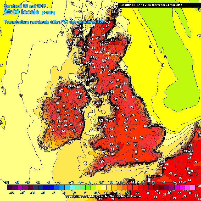
Warms up from today and signs are very good for a cracking bank holiday weekend. Not nailed on at this point...

Puggit

Original Poster:

48,516 posts

249 months

Saturday 20th May 2017
quotequote all
Current thinking is warming up considerably during the week and then big thunder storms on Sat. Watch this space...

Puggit

Original Poster:

48,516 posts

249 months

Monday 22nd May 2017
quotequote all
Melman Giraffe said:
Looks like a Hot week, possibly 30c Friday/Sat
I'm going to be thoroughly dis-chuffed if it doesn't last to my birthday on BH Monday!

Puggit

Original Poster:

48,516 posts

249 months

Tuesday 23rd May 2017
quotequote all
Evoluzione said:
What's the forecast for Sunday/Monday up North?
Should I plan for a trip to North Yorks or the Lakes?
Unfortunately the weekend forecast is not nailed on yet - different models have different ideas. This is caused by a small area of low pressure to the west, and how close it gets to the UK could make a big difference.

Keep an eye on here and I'll update when it's clearer!

Puggit

Original Poster:

48,516 posts

249 months

Tuesday 23rd May 2017
quotequote all
Becoming slowly clearer that the most likely evolution is we'll see a thundery breakdown on Saturday. Timing and locations are difficult.

Puggit

Original Poster:

48,516 posts

249 months

Wednesday 24th May 2017
quotequote all
Nothing stopping 30oC in the SE and thunder arriving from the west wink

Puggit

Original Poster:

48,516 posts

249 months

Wednesday 24th May 2017
quotequote all
LordGrover said:
Alt+0176 = °
I'll try and remember that !

Puggit

Original Poster:

48,516 posts

249 months

Wednesday 24th May 2017
quotequote all
Meh Alt+0176 doesn't work on my laptop...

29 degrees possible in northern Scotland on Friday according to this:


Storm potential for Saturday hotting up, at this moment particularly for the SE.

Puggit

Original Poster:

48,516 posts

249 months

Thursday 25th May 2017
quotequote all
MetOffice BH weekend forecast, sorry...

https://twitter.com/metoffice/status/8677759206896...

Puggit

Original Poster:

48,516 posts

249 months

Friday 26th May 2017
quotequote all
Stronger than normal chance of severe storms tomorrow. Interesting that Netweather have selected an eastern area and fairly south - I've seen some data suggesting it will be midlands and further north. Either way - be prepared for some bigguns.

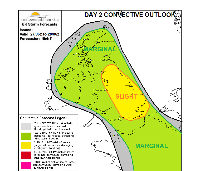
http://www.netweather.tv/index.cgi?action=convecti...


Puggit

Original Poster:

48,516 posts

249 months

Saturday 27th May 2017
quotequote all
Woken up by the dog panicking at distant thunder <yawn>

Puggit

Original Poster:

48,516 posts

249 months

Saturday 27th May 2017
quotequote all
The storm over Plymouth and South Wales was an MCS, around 100 miles in diameter. The sort of storm they have on the plains of the US.

Puggit

Original Poster:

48,516 posts

249 months

Saturday 27th May 2017
quotequote all
FlyingMeeces said:
Jeez! What factors let it happen here?
The storms in the US are caused by hot air pushing up from the Gulf of Mexico which the bumps against cool air spilling down from the Rockies...

This weather is very similar, very warm air pushing up from the south hitting cooler air from the west.

Puggit

Original Poster:

48,516 posts

249 months

Saturday 27th May 2017
quotequote all
Sunday and Monday bring more storm chances

Puggit

Original Poster:

48,516 posts

249 months

Sunday 28th May 2017
quotequote all
Potential for another poor night's sleep in the South:

http://www.convectiveweather.co.uk/forecast.php?da...

Mrs Puggit's turn with the dog!!!

Puggit

Original Poster:

48,516 posts

249 months

Sunday 28th May 2017
quotequote all
Bill said:
Just watching the rainfall radar, and can't see how the band of rain over Brittany can get to us on the south coast by 1pm as predicted by the BBC's weather report.

(Or is that just wishful thinking?)
If it's the app you're using, never trust them for accuracy!