Discussion


Quote-Red devil
Also, AFAIK no down sleeping car service ever traversed the Mallaig extension. Any through coach(es) would have been seated accommodation only.
I only mentioned the train times as per a through connection. the sleeper accommodation was to Fort William ,only,with seated coaches to Mallaig( as possibly assumed by you- moral- NEVER assume).
However, a new road memory question- as an apprentice I often travelled from Fort William to Strontian, via the Corran ferry. After a mile or so from the other side, we found that the proper road ended and further travel was over a rough rock road known as "red rocks". Come on then the PH Historians.

Who me said:
I only mentioned the train times as per a through connection.
You didn't make that point clear in your post though. 
Who me said:
the sleeper accommodation was to Fort William ,only,with seated coaches to Mallaig( as possibly assumed by you- moral- NEVER assume).
See above: I didn't assume anything.I was 99.9% sure the sleeping cars only went as far as FW even in the days of steam.
That's why I said AFAIK. If I hadn't, somebody would have found details of a special working*
Then they would have promptly popped up on here to prove me wrong.

* In that era these were quite common: just that most people never knew about them.
Who me said:
However, a new road memory question- as an apprentice I often travelled from Fort William to Strontian, via the Corran ferry. After a mile or so from the other side, we found that the proper road ended and further travel was over a rough rock road known as "red rocks". Come on then the PH Historians.
You have mentioned it before in this thread. 
In the 50s and 60s the A861 route along the shore of Loch Linnhe didn't exist.
The road went through Clovullin - http://maps.nls.uk/view/91553667
https://goo.gl/maps/zZsDu
https://goo.gl/maps/7IADt
I don't know why it was so called. It's from long before my first visit to the area.
My guess would be from the loose surface material? (granite/gniess can be pink/red).
Btw are you 'Old Git' in another place?
pb450 said:
Daft question; how do you clever chaps create and save routes in google maps these days? Being a numpty right now..... 
There is more than one way. The one I use is as follows.Open Google Maps (full version, not Lite).
In the box at top left click on the arrow Directions symbol.
Then click on the car symbol (assuming that's your mode of travel).
Type in the name of your starting city/town/village (if known).
Type in the name of your destination city/town/village (if known.)
Or
If you require a very specific start location (say your house) find it on the map.
Right click, then from the drop down menu click on 'Directions from here'.
Pick your final destination then right click again.
From the drop down menu click on 'Directions to here'.
Google will calculate the most direct route. You can then manipulate it however you want.
Hover over the blue line, pick a point then left click and drag to your heart's content.
If you have a Google account the route will be saved in Web and App activity.
It can be retrieved from there provided you haven't deleted the history.
In best Blue Peter fashion, here's one I did earlier.
Google calculated the direct route via the A4304.
I changed it by clicking, dragging, and dropping on Sibbertoft.
Then I went to the box at the top left and left clicked on the 3 horizontal bars.
From the drop down menu left I clicked on Share or embed map.
Then clicked on the Short URL box.
Copied and pasted the link to the chosen destination (in this case PH).
https://goo.gl/maps/R4khI
All of my route shortcut links are kept in a saved spreadsheet file.
It has 5 column headers:
- Geographical area (e.g. Pennines/NYM/Lake District/etc. etc.)
- Start point
- Destination
- Date
- Shortcut link
Using the 'Sort' function I can arrange them however I want.
Makes them very easy to find for future reference.
Another option is My Maps within Google Maps. Far less easy to use imo. Not a fan.
Patrick Bateman said:
I can confirm the road to Mallaig is absolutely full of dawdlers.
At least on the new road, there's every chance of passing them . In the old days ,apart from forcing past them if/when they were forced to stop to let something from the other direction pass , there was Lochailort -Glenfinnan section, a short stretch some distance after the drop from Lochailort to the loch, just before a rail viaduct (church on hill,been that long i've forgotten name ) and the "short cut" around Arisaig. Edited by Patrick Bateman on Monday 7th September 15:04
RD- Section past Corran - the old tarmac road ,when I first drove it was barely wide enough for a van and didn't follow the shore but went past Clovullin, where the old GPO Exchange cum repeater station stood, and then back round to the shore. The section known as red rocks was approximately (from memory) where the old section meets the new A861.
Who me said:
However, a new road memory question- as an apprentice I often travelled from Fort William to Strontian, via the Corran ferry. After a mile or so from the other side, we found that the proper road ended and further travel was over a rough rock road known as "red rocks". Come on then the PH Historians.
Red Devil said:
In the 50s and 60s the A861 route along the shore of Loch Linnhe didn't exist.
The road went through Clovullin - http://maps.nls.uk/view/91553667
https://goo.gl/maps/zZsDu
https://goo.gl/maps/7IADt
I don't know why it was so called. It's from long before my first visit to the area.
My guess would be from the loose surface material? (granite/gniess can be pink/red).
From that map RD, the road was tarred all the way to Strontian. So is Who me? getting confused, maybe you were going to Polloch, up the hill past the old mines, from Strontian. That shows as un-tarred from the top of the hill out of Strontian. The road went through Clovullin - http://maps.nls.uk/view/91553667
https://goo.gl/maps/zZsDu
https://goo.gl/maps/7IADt
I don't know why it was so called. It's from long before my first visit to the area.
My guess would be from the loose surface material? (granite/gniess can be pink/red).
But I suppose it depends on what years you are talking about, the map is 1960...
Edited by JM on Monday 7th September 21:30
Sometime after 1966. There definitely was a section of non tarmaced road ,where the old section from Clovullin meets the now new A861. I also remember the lad I was with commenting on the fact that the road to Strontian had only recently been tarmaced and that this was last bit of the old road . As for the other road, JM mentions , only one I know of and have driven( only once unfortunately circa 1970) is the forestry road from Scotstown ,through ( I think Polloch ), and along the shores of Loch Shiel to join the A830 halfway between where the A861( round Loch Eil)joins the A830 and Glenfinnan, and on the Glenfinnan side of one of the lowest rail bridges in the area. The road is more of a packed sand/earth type construction ,and a very nice scenic drive, but alas, it's gated at the Glenfinnan end.
JM said:
From that map RD, the road was tarred all the way to Strontian. So is Who me? getting confused, maybe you were going to Polloch, up the hill past the old mines, from Strontian. That shows as un-tarred from the top of the hill out of Strontian.
But I suppose it depends on what years you are talking about, the map is 1960...
Back then the unclassified tarmac road from Strontian past Scotstown only went as far as here - https://goo.gl/maps/N2AU0But I suppose it depends on what years you are talking about, the map is 1960...
From there a 'white' (i.e. untarred) road/track did indeed go past the old mines and through Polloch to the shore of Loch Linnhe.
In Google satellite view you can trace the course of the hairpin bends through the woods beyond the village to where it ends in a jetty.
Back then Pollach was a very isolated place. Access to Moidart would have been by boat to Daleila pier - https://goo.gl/maps/GPmQW - and/or the jetty to the east.
From Strontian though there were classified roads into both Ardnamurchan and Moidart.
Who me said:
As for the other road, JM mentions , only one I know of and have driven( only once unfortunately circa 1970) is the forestry road from Scotstown ,through ( I think Polloch ), and along the shores of Loch Shiel to join the A830 halfway between where the A861( round Loch Eil)joins the A830 and Glenfinnan, and on the Glenfinnan side of one of the lowest rail bridges in the area. The road is more of a packed sand/earth type construction ,and a very nice scenic drive, but alas, it's gated at the Glenfinnan end.
On the 1960 map, a footpath/bridleway begins at the top of the hill prior to the aforementioned hairpin bends.It climbs up and along the flank of Meall Odhar then down to Gortstanvorran and on to Scamodale and Glenfinnan.
There was no road along that part of Loch Shiel until 1967 (see below).
The full route you and JM mention - https://goo.gl/maps/JTljm
The Forestry Commission road from the south through Glen Hurich Forest starts here - https://goo.gl/maps/PtcS6
The Glenfinnan end - https://goo.gl/maps/Ljz8M
The gate is not visible and the Google car didn't go down that road, so no Streetview image is available.
I'm guessing the gate is located after the road crosses the River Callop.
Some pics of the construction of the road from Callop gate into to Glen Hurich Forest and Polloch.
http://www.forestry-memories.org.uk/picture/number...
http://www.forestry-memories.org.uk/picture/number...
http://www.forestry-memories.org.uk/picture/number...
It's a reasonable assumption that it was extended past the southern FC boundary at the same time.
It would then link up with the existing unclassified tarmac road below the old mines.
Red Devil said:
There is more than one way. The one I use is as follows.
Open Google Maps (full version, not Lite)....
Thanks Anthony, much appreciated. I can't be sure that I don't have the Lite version and 'classic' has now gone, which was far more user friendly. I will persist with the version I have but the drag and drop method does strange things with 'detours' that are hard to smooth out sometimes. Persistence!Open Google Maps (full version, not Lite)....
Red Devil said:
On the 1960 map, a footpath/bridleway begins at the top of the hill prior to the aforementioned hairpin bends.
It climbs up and along the flank of Meall Odhar then down to Gortstanvorran and on to Scamodale and Glenfinnan.
There was no road along that part of Loch Shiel until 1967 (see below).
The full route you and JM mention - https://goo.gl/maps/JTljm
The Forestry Commission road from the south through Glen Hurich Forest starts here - https://goo.gl/maps/PtcS6
The Glenfinnan end - https://goo.gl/maps/Ljz8M
The gate is not visible and the Google car didn't go down that road, so no Streetview image is available.
I'm guessing the gate is located after the road crosses the River Callop.
Some pics of the construction of the road from Callop gate into to Glen Hurich Forest and Polloch.
http://www.forestry-memories.org.uk/picture/number...
http://www.forestry-memories.org.uk/picture/number...
http://www.forestry-memories.org.uk/picture/number...
It's a reasonable assumption that it was extended past the southern FC boundary at the same time.
It would then link up with the existing unclassified tarmac road below the old mines.
The Loch Shiel road is generally very good gravel but with some large potholes. I drove it (had access and a reason to drive it) about 5 years ago. 15mph was plenty fast enough. The gate at the north end is indeed once the Callop is crossed. There is a generous parking area nearby for those wanting to head into the hills. It climbs up and along the flank of Meall Odhar then down to Gortstanvorran and on to Scamodale and Glenfinnan.
There was no road along that part of Loch Shiel until 1967 (see below).
The full route you and JM mention - https://goo.gl/maps/JTljm
The Forestry Commission road from the south through Glen Hurich Forest starts here - https://goo.gl/maps/PtcS6
The Glenfinnan end - https://goo.gl/maps/Ljz8M
The gate is not visible and the Google car didn't go down that road, so no Streetview image is available.
I'm guessing the gate is located after the road crosses the River Callop.
Some pics of the construction of the road from Callop gate into to Glen Hurich Forest and Polloch.
http://www.forestry-memories.org.uk/picture/number...
http://www.forestry-memories.org.uk/picture/number...
http://www.forestry-memories.org.uk/picture/number...
It's a reasonable assumption that it was extended past the southern FC boundary at the same time.
It would then link up with the existing unclassified tarmac road below the old mines.
pb450 said:
Thanks Anthony, much appreciated. I can't be sure that I don't have the Lite version and 'classic' has now gone, which was far more user friendly.
Happy to help. Indeed it was and I much preferred it. For a while you could switch between the two versions.Then, in the typical Google 'take it or leave it' attitude to its clientele, that choice was taken away.
Several people found backdoors but, as soon as they were shared over the interweb and social media, it ruthlessly suppressed them.
Lite mode is easily recognised as it doesn't have any Show imagery thumbnail pics next to the Streetview yellow man.
You can switch between Lite and Full by clicking on the lightning bolt symbol (see link below)
pb450 said:
I will persist with the version I have but the drag and drop method does strange things with 'detours' that are hard to smooth out sometimes. Persistence!
You must already be in Full mode. You can plan a route using the right click Directions to/Directions from method in Lite, but it won't then let you drag and drop to alter it.Several other features are disabled as well. To name but one example: you can't get rid of those irritating greyed out alternatives either - https://www.google.com/maps/dir/The+Ardingly+Inn/T...
sjabrown said:
The Loch Shiel road is generally very good gravel but with some large potholes. I drove it (had access and a reason to drive it) about 5 years ago. 15mph was plenty fast enough.
Perfect for a rally stage then. 
 I still miss my BDA engined Escort Mexico,
sjabrown said:
The gate at the north end is indeed once the Callop is crossed. There is a generous parking area nearby for those wanting to head into the hills.
- 
Aha, that's cracked it then with the 'Show imagery' stuff beside the little man. I am indeed on full-fat version. Thank you sir.
On another note, I met a fellow TVR driver at the weekend who pointed me in the direction of the North Coast 500, (516 miles actually) which I have since researched. Seems ok, slightly surprised it's not been mentioned on this thread. (maybe it has but I'm not trawling back again through 103 pages, having read the lot!) Planning a major road trip in 2017 (yes, I know, VERY advanced planning) and interested in opinions of this heavily plugged route.
I can imagine it's quite good until the world and his wife all jump on it, due to the publicity. Anyone tried it? Reactions? Alternatives?
pb450 said:
Aha, that's cracked it then with the 'Show imagery' stuff beside the little man. I am indeed on full-fat version. Thank you sir.
On another note, I met a fellow TVR driver at the weekend who pointed me in the direction of the North Coast 500, (516 miles actually) which I have since researched. Seems ok, slightly surprised it's not been mentioned on this thread. (maybe it has but I'm not trawling back again through 103 pages, having read the lot!) Planning a major road trip in 2017 (yes, I know, VERY advanced planning) and interested in opinions of this heavily plugged route.
I can imagine it's quite good until the world and his wife all jump on it, due to the publicity. Anyone tried it? Reactions? Alternatives?
The main thing that would put me off. Plus the petrol...On another note, I met a fellow TVR driver at the weekend who pointed me in the direction of the North Coast 500, (516 miles actually) which I have since researched. Seems ok, slightly surprised it's not been mentioned on this thread. (maybe it has but I'm not trawling back again through 103 pages, having read the lot!) Planning a major road trip in 2017 (yes, I know, VERY advanced planning) and interested in opinions of this heavily plugged route.
I can imagine it's quite good until the world and his wife all jump on it, due to the publicity. Anyone tried it? Reactions? Alternatives?
pb450 said:
Aha, that's cracked it then with the 'Show imagery' stuff beside the little man. I am indeed on full-fat version. Thank you sir.
On another note, I met a fellow TVR driver at the weekend who pointed me in the direction of the North Coast 500, (516 miles actually) which I have since researched. Seems ok, slightly surprised it's not been mentioned on this thread. (maybe it has but I'm not trawling back again through 103 pages, having read the lot!) Planning a major road trip in 2017 (yes, I know, VERY advanced planning) and interested in opinions of this heavily plugged route.
I can imagine it's quite good until the world and his wife all jump on it, due to the publicity. Anyone tried it? Reactions? Alternatives?
There is a report of someone on here doing it a few weeks ago, he said there was only one section that was "busy". On another note, I met a fellow TVR driver at the weekend who pointed me in the direction of the North Coast 500, (516 miles actually) which I have since researched. Seems ok, slightly surprised it's not been mentioned on this thread. (maybe it has but I'm not trawling back again through 103 pages, having read the lot!) Planning a major road trip in 2017 (yes, I know, VERY advanced planning) and interested in opinions of this heavily plugged route.
I can imagine it's quite good until the world and his wife all jump on it, due to the publicity. Anyone tried it? Reactions? Alternatives?
The route is a circular route from Inverness, there is no real alternative roads if you wish to cover all the places on the route, in one go. Plenty of people have done it in various sections.
Best time to go is probably May/June, outwith any possible holiday weekends.
pb450 said:
Just googled it. Djdan did it in a Tuscan S (Yay!) back in August and has written a brilliant piece on the General Gassing page. Worth a read. Oh, so many plans to make.... 
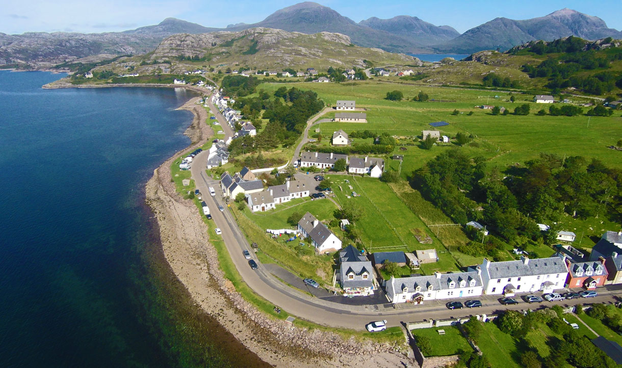
I live here (You'll pass my house on the west coast). As mentioned, it's the time of year that is important. AVOID JULY / AUGUST! Apart from the traffic & midges, it's usually crap weather.As is often the case, September brings out the sunshine. This is the local village today:
Edited by GetCarter on Tuesday 8th September 16:03
JM said:
Best time to go is probably May/June, outwith any possible holiday weekends.
I'm in Kent so for me it's all well over 500 miles away and anything less than 6-7 days overall isn't worth considering.I would say go a bit earlier - mid April to mid May. Hardly a tourist to be seen, deserted roads, and well before the biting midges get their act together.
Our preference is mid-April. One year we got our dates wrong and realised too late that we had included the Easter break!

The Monday is not a Bank Holiday in Scotland and the Scots don't seem to make that weekend the big deal the English do.
We need not have been concerned. Beyond Tyndrum the roads were just as free of of traffic as all the other years.
I'm from Kent too, so likewise the 500 mile bash first (and last) just to get there. Luckily we have good friends in Edinburgh so a couple of days will be spent with them en-route. Like you Anthony, we're thinking of late April, early May. Beats the midges and the traffic, hopefully. Also fits in with our domestic circumstances.
Nice drone work there Mr Carter.
Nice drone work there Mr Carter.


Gassing Station | Roads | Top of Page | What's New | My Stuff