Discussion


Lancs Dave said:
John A said:
No, he's quite correct. That's a picture from Uig (Skye) looking towards Waternish (also Skye)
I stand corrected. It's looking further around to the left than it thought :-)
For starters, it's much too close to be Harris, which is out of sight behind the the headland on the right.
My photo was taken with a telephoto lens from the same spot as in the Google Maps link.
Rotate 180° and you will see the raised overgrown bank I was standing on.
The bit of land just visible poking out of the sea fog is not Skye but the island of South Ascrib.
http://www.streetmap.co.uk/map.srf?x=130500&y=...
Lancs Dave said:
We head up there on 16th, might see you around
If that's in April, it's possible. What's your itinerary? PM me if you prefer. 
GetCarter said:
I can add to that:
Dingwall
Gairloch
Lochcarron (24 hr with card reader)
Applecross (24 hr with card reader)
A few more, not sure if these are relevant to your route though. Dingwall
Gairloch
Lochcarron (24 hr with card reader)
Applecross (24 hr with card reader)
Invergarry (just past the A87 junction on the north side)
Inversheil (A87)
Inverinate (A87)
Cluanie Inn (A87)
Contin (Ullapool / Gairloch Road)
Alness (Hill road to Bonar Bridge)
Durness (While since I've been up there though)
Uig
Fort Augustus
GetCarter may know better than me but last time I was through (mid Jan) Kinlochewe the petrol station was closed at midday? Just on holiday perhaps?
Looks like I'll be visiting the Torridon/Gairloch area in the first week of April. Can I trust removing my winter tyres the week before won't be a regrettable decision?
While we're at it, any particular highlights in terms of driving roads on the route (ignoring Applecross)? That is to say, stretches that aren't the single track sections that you need to take it easy on.
https://www.google.co.uk/maps/dir/Fort+William/App...
While we're at it, any particular highlights in terms of driving roads on the route (ignoring Applecross)? That is to say, stretches that aren't the single track sections that you need to take it easy on.
https://www.google.co.uk/maps/dir/Fort+William/App...
Edited by Patrick Bateman on Tuesday 16th February 23:08
Patrick Bateman said:
Looks like I'll be visiting the Torridon/Gairloch area in the first week of April. Can I trust removing my winter tyres the week before won't be a regrettable decision?
I'd say keep them on, fair chance you won't need them but it really is hit and miss at that time of year. At the start of April I've driven through blizzards on the a87 and also over the Bealach na Ba then in Applecross it was like a summers day. Winters are always good in the wet too. cat220 said:
I'd say keep them on, fair chance you won't need them but it really is hit and miss at that time of year. At the start of April I've driven through blizzards on the a87 and also over the Bealach na Ba then in Applecross it was like a summers day. Winters are always good in the wet too.
I'll have a think. See what the forecasts are like at the time. Hopefully there's a warm spell as pushing the car on winters feels crap and these roads deserve it, managed to make an interesting loop of it all.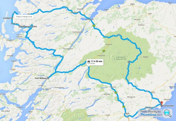
Worth staying on the A939 North of Grantown instead?
Edited by Patrick Bateman on Tuesday 16th February 23:53
Patrick Bateman said:
cat220 said:
I'd say keep them on, fair chance you won't need them but it really is hit and miss at that time of year. At the start of April I've driven through blizzards on the a87 and also over the Bealach na Ba then in Applecross it was like a summers day. Winters are always good in the wet too.
I'll have a think. See what the forecasts are like at the time. Hopefully there's a warm spell as pushing the car on winters feels crap and these roads deserve it, managed to make an interesting loop of it all.Worth staying on the A939 North of Grantown instead?
Edited by Patrick Bateman on Tuesday 16th February 23:53
Summers should be fine on the west coast by then (A9 Perth > Inverness can still be a nightmare). As mentioned, the Bealach can be fun - right into May. Trick is to go up after Finky in his spreader lorry. They close the road if it's proper bad. (Coast road /alt route) is still fun and I've never known it closed.
It's when it looks like this you have to be a bit careful.. as it looks ok... then you look at the outside temp - 2300 feet up you can be 5C lower than you were when you started at sea level 10 minutes earlier:
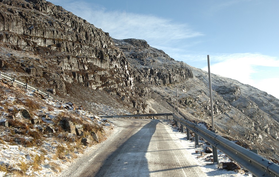
It's when it looks like this you have to be a bit careful.. as it looks ok... then you look at the outside temp - 2300 feet up you can be 5C lower than you were when you started at sea level 10 minutes earlier:
Edited by GetCarter on Wednesday 17th February 15:33
Peanut Gallery said:
I would also extend the loop slightly and go via Glencoe on your way to or from Fort William, either joining up through the A82 and Crianlarich, or on the smaller roads though Tempar.
Have done this plenty as the girlfriend is working in Fort William so I'll be looking for the quickest way back by that point anyway. Ever since the first of the torrential rain flooding the roads in early December I've started going the A9 with the cruise control on and it's much more relaxing.The scenery is outstanding and the road does have a few fun sections along the way but on the whole I don't rate it that highly for actual driving*. The chances of enjoying the fun sections are also slim due to the inevitable dawdlers, even ignoring the busy summer months and being fairly early.
- Kinlochleven loop notwithstanding
Patrick Bateman said:
Looks like I'll be visiting the Torridon/Gairloch area in the first week of April. Can I trust removing my winter tyres the week before won't be a regrettable decision?
I have been up there (as well as the far north: Durness/Tongue/etc.) in mid April nearly every year from 2009 onwards without ever needing winter tyres.Altnaharra (almost midway between Tongue and Lairg shares (with Braemar) the record for the lowest ever temperature in the UK (?27.2°C).
On my most recent visit I was perfectly comfortable in a thin short sleeved T-shirt.

Patrick Bateman said:
While we're at it, any particular highlights in terms of driving roads on the route (ignoring Applecross)? That is to say, stretches that aren't the single track sections that you need to take it easy on.
https://www.google.co.uk/maps/dir/Fort+William/App...
The entire A87 part of your route. This explains why - http://www.bestbikingroads.com/motorcycle-roads/mo...https://www.google.co.uk/maps/dir/Fort+William/App...
The A890 from Auchentyre to Strathcarron isn't bad either. Quite a few sharp elevation changes coupled with deceptive bends.
You can get caught out if you're not concentrating. Several single track sections where it is next to the Dingwall-Kyle line alongside Loch Carron.
Like this one - https://goo.gl/maps/EVRY2tzduqo
Patrick Bateman said:
Worth staying on the A939 North of Grantown instead?
Definitely. The A9 has nothing to recommend it imo. Get off it asap and avoid the average speed cameras.
Use the B roads via Cawdor to the A939 instead - https://goo.gl/maps/tzzp3fnXzrL2
Edited by Red Devil on Thursday 18th February 03:04
Gassing Station | Roads | Top of Page | What's New | My Stuff