Calling Red Devil .... Location needed.
Discussion


So, a genuine question RD, where is this section of road :
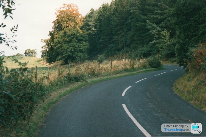
I can narrow its location down a bit, it could be "around" Ellesmere, possibly Cholmondley/Castle or some castle ruins with a moat ? in a village whereby the road runs right alongside them ??
Having looked at the map more closely, that'll be Whittington
So somewhere around Whittington Sorry I can't be anymore helpful than that.
I can narrow its location down a bit, it could be "around" Ellesmere, possibly Cholmondley/Castle or some castle ruins with a moat ? in a village whereby the road runs right alongside them ??
Having looked at the map more closely, that'll be Whittington
So somewhere around Whittington
Sorry I can't be anymore helpful than that.Red Devil said:
I'm flattered by your estimation of my abilities.
However the likelihood of my recognising a random bit of B road from a few trees bordering a double bend is a bit tenuous!
What makes you think the location is on the borders of Cheshire/Shropshire btw?
Cos I remember the drive. However the likelihood of my recognising a random bit of B road from a few trees bordering a double bend is a bit tenuous!
What makes you think the location is on the borders of Cheshire/Shropshire btw?
but not the road 
Red Devil said:
If you can tell me where your start and end points were that might help.
I may need to call upon the assistance of John H. Watson though...
I may need to call upon the assistance of John H. Watson though...
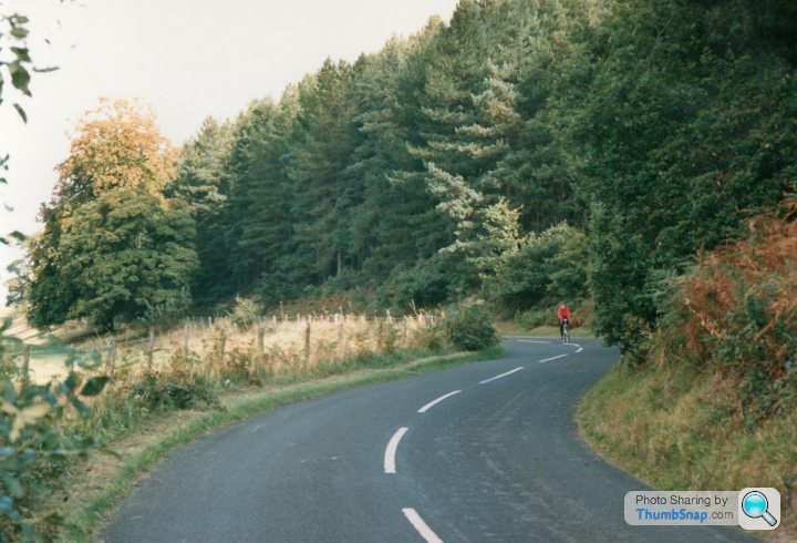
If I knew that, I'd happily spend an hour on GMaps and establish the location myself, but I thought with your "photographic memory" you may have been able to recall the location.I suspect the images were taken sometime between '86 and '89 after I'd been spectating on a gravel event in Dyfi or Coed Y Brenin. I was heading back to Threapwood (between Whitchurch and Wrexham).
The most direct route from Coed-y-Brenin to Threapwood would be Bala->Corwen->Llangollen->Ruabon.
Can't think of anywhere on that which might resemble the photos.
However you mentioned Whittington, which would imply a return route via Oswestry.
The bank of trees on the right are evergreens/conifers which suggests a location further west.
As does the terrain: east of the A5 is much flatter and more open. Still not ringing any bells though.
With only a double bend and some trees to work with it's makes identification a tad difficult.
Plus Wales isn't my destination of choice so I'm not as well acquainted with it as other areas.
Red Devil said:
The most direct route from Coed-y-Brenin to Threapwood would be Bala->Corwen->Llangollen->Ruabon.
Can't think of anywhere on that which might resemble the photos.
However you mentioned Whittington, which would imply a return route via Oswestry.
The bank of trees on the right are evergreens/conifers which suggests a location further west.
As does the terrain: east of the A5 is much flatter and more open. Still not ringing any bells though.
With only a double bend and some trees to work with it's makes identification a tad difficult.
Plus Wales isn't my destination of choice so I'm not as well acquainted with it as other areas.
I have other pictures taken on the same journey, I just can't find them currently .... Looking at the map I think Dyfi is more likely than Coed y Brenin.Can't think of anywhere on that which might resemble the photos.
However you mentioned Whittington, which would imply a return route via Oswestry.
The bank of trees on the right are evergreens/conifers which suggests a location further west.
As does the terrain: east of the A5 is much flatter and more open. Still not ringing any bells though.
With only a double bend and some trees to work with it's makes identification a tad difficult.
Plus Wales isn't my destination of choice so I'm not as well acquainted with it as other areas.
Slippydiff said:
Red Devil said:
The most direct route from Coed-y-Brenin to Threapwood would be Bala->Corwen->Llangollen->Ruabon.
Can't think of anywhere on that which might resemble the photos.
However you mentioned Whittington, which would imply a return route via Oswestry.
The bank of trees on the right are evergreens/conifers which suggests a location further west.
As does the terrain: east of the A5 is much flatter and more open. Still not ringing any bells though.
With only a double bend and some trees to work with it's makes identification a tad difficult.
Plus Wales isn't my destination of choice so I'm not as well acquainted with it as other areas.
I have other pictures taken on the same journey, I just can't find them currently .... Looking at the map I think Dyfi is more likely than Coed y Brenin.Can't think of anywhere on that which might resemble the photos.
However you mentioned Whittington, which would imply a return route via Oswestry.
The bank of trees on the right are evergreens/conifers which suggests a location further west.
As does the terrain: east of the A5 is much flatter and more open. Still not ringing any bells though.
With only a double bend and some trees to work with it's makes identification a tad difficult.
Plus Wales isn't my destination of choice so I'm not as well acquainted with it as other areas.
The OP said he was on his way home from Wales so it seems reasonable to conclude that the photos were taken in the direction of travel although I am aware they might not be!
I had already ruled out that section of the B4391: it has a white line bordering each verge all the way from the Pen-y Bont Caravan and Camping Park to a tad under one mile from Pencraig.
I had already ruled out that section of the B4391: it has a white line bordering each verge all the way from the Pen-y Bont Caravan and Camping Park to a tad under one mile from Pencraig.
Red Devil said:
The OP said he was on his way home from Wales so it seems reasonable to conclude that the photos were taken in the direction of travel although I am aware they might not be!
I had already ruled out that section of the B4391: it has a white line bordering each verge all the way from the Pen-y Bont Caravan and Camping Park to a tad under one mile from Pencraig.
That's fair comment - I didn't use Street View to confirm as the road has been re-tarred and gravelled several times since 89 so I'm aware the road markings may have changed and I don't thiink I have any photos of that section to confirm at that time. The scenery is reminiscent of the area around the Franktons - the slightly 'parkland' feel although the pine trees don't quite fit. It doesn't seem like the A495 from what I can recall, maybe the B4397 but I can't place it and don't have knowledge of the user's preferred routes on a return from Wales and whether he would have taken a slightly circuitous routeI had already ruled out that section of the B4391: it has a white line bordering each verge all the way from the Pen-y Bont Caravan and Camping Park to a tad under one mile from Pencraig.
On second thoughts, you have a point. If those photos are indeed from as long ago as the mid to late 1980s the white lines I referred to may not have existed then (on that and many other roads in Wales). I'm going to have to have a rethink! If the starting point was Dyfi rather than Coed-y-Brenin that widens the net a bit as well. I suspect those photos may have been taken with a long lens. If so, it will make the double bend appear sharper than it really is which doesn't help either...
The field on the left of the images has the "feel" of the fields alongside the A495 from Welshampton to Ellesmere (before they widened it), a road I know well. The section of road I photographed is even narrower than the A495 (pre-widening)
https://www.google.co.uk/maps/@52.9025607,-2.87340...
https://www.google.co.uk/maps/@52.9025607,-2.87340...
Gassing Station | Roads | Top of Page | What's New | My Stuff