What's the best android sat nav app?
Discussion


I've been trying out various android sat nav apps as my current Garmin Sat Nav is getting on a bit (and it failed with routes a few times in France), the following are the ones I've tried and none of them seem as good as an actual sat nav...
HERE maps - offline maps but routes seem to be a little odd...
not very pretty display and keeps losing gps signal
Also will not show TomTom speed cam app on display
Waze - needs data - no good in rural east anglia! But i'm sure it's great in cities.
Google Maps - no current speed? or speed cam data.
TomTom - looks and works OK but costs £30 per year.
Any other great sat nav apps that I should try before I just give in and buy a Tom Tom sat nav?
I find tomtom good. It picks up on traffic using its own system and that is its best feature, along with its suggestions of alternative routes as you're driving if they become quicker than the current one. Its camera warnings (although you have to pay more for those) are also very accurate.
Waze caches the map when it calculates the route so do your route planning while connected to wifi and don't close the app and it will be on the device for the duration.
Having used Waze for the first time a couple of weeks ago I think the community stuff is brilliant. It saved me a good 30 minutes on 2 hour trip last week.
One thing though, as it only gives verbal speed camera warnings if you're over the speed limit and assumes all variable speed limits on motorways are 70mph. Means you're only going to get visual alert if you're doing 69 mph in a 50 mph variable limit.
Having travelled the same 120 mile trip every week for a number of months, and having tried all the above, I found that by far the best routing came from Google Maps. I strongly suspect that it has the most up to date traffic data, so was the best at routing around any issues.
I use CamerAlert (from PocketGPSWorld) for a very up-to-date speed camera database; it is updated at least weekly and includes mobile sites. It can be used as an overlay with any navigation app.
I use Velociraptor to show the current speed limit, which it gets from Open Street Map and is generally accurate. It can also warn when you are a set amount over the limit (I have mine set to 10% + 2mph). It can show your current speed, although I prefer the display from SpeedOverlay to do this.
I use Automagic to start all of the above apps when my phone detects that it has connected to the Bluetooth in any of my cars, and to close them all down when I disconnect from the cars' Bluetooth.
Thought I give Sybic a try. Didn't even get as far as the Nav tbh.
Bit frustrating have to keep swiping away the pop ups saying to upgrade.
Putting destination in if you want to clear the last entry i.e street it seems to clear the whole lot an you have to start again.
Putting in my work address didn't work. Sets up for another street the same name other side of town even though it's clearly shown on the maps.
Pretty but not for me. Uninsalled. Back to copilot.
I'm probably biased as a beta tester and area manager but I find Waze covers most of the bases perfectly well for me.
If the data isn't there to meet your needs that can be an issue but the simple fix is to add it, either manually on the Waze editor app or by "paving" roads with the phone app if you travel them and they don't exist. It's likely a willing editor will then add these if they are missing.
When I first started to use it there were no roads, not even the ones in central Leeds, I paved them, added them manually, set directions, turn limitations etc until the infrastructure worked. Years later they actually bought some base maps so the majority of the road network is now covered and editors can enhance this and add to it. When I had issues with TomTom maps not including a major road in Leeds it took me over a year until it finally appeared, with Waze we can add roads as they are being built and then just enable them once they open.
Actual traffic data relies on other Waze users and I wish they would tap into the Google parent cache of Android / Google Maps data to help make this more useful but it only takes a couple of people or one active Waze user reporting issues to really make things work well.
On occasion I hire cars with Android head units and use Google Maps (Waze is due to work on them soon I believe) and while it's good it's just not quite as good as Waze.
This said there is room for improvement and the guidance is only as good as the maps / editors so some areas are better than others - it's evolving constantly and seems to be getting better and better in my opinion.
Oh and I'm keen to get more people on there so my experience is enhanced due to all the extra data
Waze is owned by Google you know.
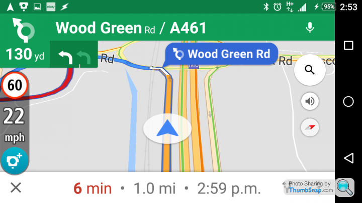
OK I use Google maps as prime, Here as backup and this
https://play.google.com/store/apps/details?id=com....
Tomtom Speed Cameras (free) as an overlay. (Velociraptor isn't that great)
Google maps do offline too now btw, if you have the storage space.
All wrapped up in this. Carhome Ultra
https://play.google.com/store/apps/details?id=spin...
This means with my phone on its mount I can do anything journey related, make calls (bluetooth) map directions, current speed, speed cameras, hell even congestion via the tomtom overlay.
Android btw, Iphone lot need to look elsewhere.
Edited by techguyone on Friday 9th September 13:01
techguyone said:
Waze is owned by Google you know.
I do, that's why I said "Google parent" in my earlier post - they need to come up with a way of combining the best of both apps and allowing users to switch on / off the stuff they like to tailor it to their needs. Hardcore Google nav people might not want to collect "road goodies" or report road issues manually, likewise Waze users might not want the visuals of Google Nav. 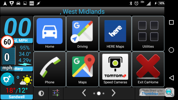
Gassing Station | In-Car Electronics | Top of Page | What's New | My Stuff