WW2 London bomb maps (link inside!)
Discussion


Curious about bomb damage during WW2 in my area so was googling a bit last night. I found these photographs of the official LCC maps on Flickr. They're very interesting.
http://www.flickr.com/photos/yersinia/2948640929/
Once you have got into the map, click on 'all sizes' at the top and then the highest resolution. The quality isn't great but can't complain too much.
Somebody has started putting it on googlemaps, but for V2 bombs only ( link
http://www.flickr.com/photos/yersinia/2948640929/
Once you have got into the map, click on 'all sizes' at the top and then the highest resolution. The quality isn't great but can't complain too much.
Somebody has started putting it on googlemaps, but for V2 bombs only ( link

Yes, I've 'got' a V1 hit around the corner, I've walked past it a few times but I think it must have been rebuilt in period.
A friend's street not far away has a park about half way down it that links through the the next street. I always thought it was a bit out of place, turns out if was a V1 hit and obviously never rebuilt. There may be a memorial there.
A friend's street not far away has a park about half way down it that links through the the next street. I always thought it was a bit out of place, turns out if was a V1 hit and obviously never rebuilt. There may be a memorial there.

Fantastic 
The devastation around St Paul's on section 62 is alarming even when you know from history how heavily it was bombed/targetted.
The tower seems unmarked - or is that because its a military site and details wouldn't be published ? Buckingham Palace too, and we know that got hit on more than one occasion.
 ...you beaut
I've got the atlas which covers the whole of London, published by the London Topographical Society, which is fascinating. It shows bomb damage degrees across London and where V1 & V2 rockets landed. Now out of print, unfortunately.
If you like this sort of thing, I highly recommend joining the LTS. The annual publication is usually worth several times the subscription, and has included, over the years, simple small books of articles, limited edition drawings and reproductions, and the atlas.
http://www.topsoc.org/index.htm
If you like this sort of thing, I highly recommend joining the LTS. The annual publication is usually worth several times the subscription, and has included, over the years, simple small books of articles, limited edition drawings and reproductions, and the atlas.
http://www.topsoc.org/index.htm
Anyone have ideas about the coding. I'm seeing buildings marked in black, purple brown and tan, presumably meaning levels of damage, and circles (presumably rockets).
Certainly explains the state of my road, but one local notorious incident (the bombing of a dance hall) seems to be missing.
Certainly explains the state of my road, but one local notorious incident (the bombing of a dance hall) seems to be missing.
Key
Black - Total destruction
Purple - Damage beyond repair
Dark Red - Seriously damaged, doubtful if repairable
Light Red - Seriously damaged, repairable at cost
Orange - General blast damage, minor in nature
Yellow - Blast damage, minor in nature
Green - Clearance areas
Small circle - V2 Bomb
Large circle - V1 bomb
Actually, i've been researching this for the last week or too for Birmingham.
There is a combined map in the central library where all the bombs, (including type - HE, Incendiary or UXB) and also any downed Luftwaffe stuff.
A German bomber apparently crashed/crash landed about half a mile from me, so i'm trying to discover if that is true.
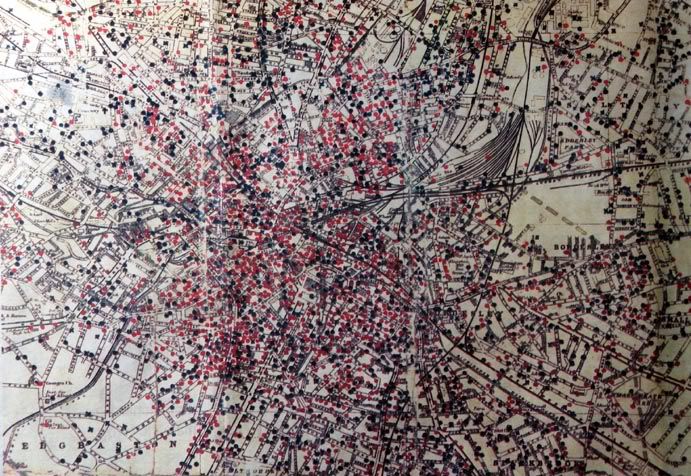
That's a pic of a B'ham city bomb map (i don't have anything in higher res though)

And a B'ham pub
There is a combined map in the central library where all the bombs, (including type - HE, Incendiary or UXB) and also any downed Luftwaffe stuff.
A German bomber apparently crashed/crash landed about half a mile from me, so i'm trying to discover if that is true.
That's a pic of a B'ham city bomb map (i don't have anything in higher res though)
And a B'ham pub
I forgot to mention this as well
http://www.swanshurst.org/barra/search.asp
It's a searchable archive of Birmingham Air Raid Casualties
http://www.swanshurst.org/barra/search.asp
It's a searchable archive of Birmingham Air Raid Casualties
Eric Mc said:
As did the House of Commons.
I'm considering contacting the Luftwaffe to ask if they are interested in coming back for a second go.
Unfortunately the occupants are too busy with their property improvements to bother with attending most of the time so it wouldn't change much, except the view from Westminster Bridge.I'm considering contacting the Luftwaffe to ask if they are interested in coming back for a second go.
Went to a talk on bomb damage on the Southern last night. Stories of passengers waiting on the station platforms while the Bomb Squad disarmed the latest crop of bombs nearby. If they had done the sort of precautionary evacuation they do today nothing would ever have moved.
Gassing Station | The Lounge | Top of Page | What's New | My Stuff