Help required undertanding a WW1 map reference
Discussion


I'm not sure if this is the correct section - but here it goes anyway.
I've been looking at some documents relating to my Great Uncle who was killed in France in WW1
It appears his body was exhumed and then buried at a proper cemetery and I'm trying to figure out where the body was exhumed from.
From the documents I've found in one column it gives a map reference - but this it where I get lost.
There appears to be too many digits (and letters) for it to be a normal map ref.
Can any body help?
What I've got is:
SH.62D. J.26.d.90.30
Many Thanks
It might be simpler to search for him using the Commonwealth War Graves Commission site : http://www.cwgc.org/
France uses a different mapping system to the UK's Ordinance Survey, they use IGN references amongst others. Try their Geoportail:-
http://www.geoportail.gouv.fr/accueil
You could try those reference on here with a little translation.
Good luck with the search
Paul
http://www.geoportail.gouv.fr/accueil
You could try those reference on here with a little translation.
Good luck with the search
Paul
62d might be the departemont number 62 pas-de-calais which saw some heavy fighting I think cant make anything else out. As a clue which cemetery was he reburied in?
On more research 62300 is the town of Lens which is 6.98km from Vimy would the date of his death help narrow it down?
Edited by mad4amanda on Thursday 23 October 18:29
On more research 62300 is the town of Lens which is 6.98km from Vimy would the date of his death help narrow it down?
Edited by mad4amanda on Thursday 23 October 18:51
Edited by mad4amanda on Thursday 23 October 18:53
Squiggs said:
I'm not sure if this is the correct section - but here it goes anyway.
I've been looking at some documents relating to my Great Uncle who was killed in France in WW1
It appears his body was exhumed and then buried at a proper cemetery and I'm trying to figure out where the body was exhumed from.
From the documents I've found in one column it gives a map reference - but this it where I get lost.
There appears to be too many digits (and letters) for it to be a normal map ref.
Can any body help?
What I've got is:
SH.62D. J.26.d.90.30
Many Thanks
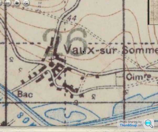
SH.62D. is a map reference, google it there are quite a few that refer to it. Bouzencourt appears to be the area from a quick google. Then I guess the next bit is a grid ref. I've been looking at some documents relating to my Great Uncle who was killed in France in WW1
It appears his body was exhumed and then buried at a proper cemetery and I'm trying to figure out where the body was exhumed from.
From the documents I've found in one column it gives a map reference - but this it where I get lost.
There appears to be too many digits (and letters) for it to be a normal map ref.
Can any body help?
What I've got is:
SH.62D. J.26.d.90.30
Many Thanks
Check out this link: http://www.greatwar.co.uk/research/maps/british-ar...
You are looking for Map Sheet (SH) 62D which is Méault area. Then it is J (6,000 yard square A-X), 26 (1,000 yard square 1-36), d (one of four 500 yard sections a-d), the next part has me thrown a little as it should be 100 yard grid co-ords Eastings and Northings numbered 0-9, whereas you have 90.30. So I would say that you are looking at 9.3 only the person writing the co-ords have tried to be as accurate as possible.
Hope that helps you out, the next part will be finding the bloody map!
Edited to add: you might not need to, it seems there is a large Military cemetary in Meaulte so you might be lucky. Do you have a first and a last name, if you send me a message with it I will try to dig further. I'm serving Forces so happy to help you out so you can pay your respects
Edited by BaronVonV8 on Thursday 23 October 18:52
Edited by BaronVonV8 on Thursday 23 October 18:52
I've gotten it down to here but might have the wrong map
https://www.google.com/maps?q=M%C3%A9zi%C3%A8res+s...
https://www.google.com/maps?q=M%C3%A9zi%C3%A8res+s...
Thanks for your help everybody.
Since the post that first mentioned that France uses a different type of grid system I kept digging and came up with WW1 Trench maps - which is what BaronVon8 & cptsideways are alluding to.
I've visited my Great Uncles final resting place at Villers-Bretonneux Millitary Cemetary (An Australian Cemetery?) - but only recently found out that his body had previously been exhumed from the above map ref.
I also have a photo of my Great Granma and Granddad standing at his grave, which I presume was taken shortly after the war.
The photo bears little resemblance to the grave or cemetery I visited, so I presume his body was exhumed from where the photo was taken (the map ref) and I'm trying to find out where that was.
Thanks for your help.
I'm narrowing it down.
Get on google streetview, I have a hunch it might look like somewhere like this. Its on the grid ref as far as I can tell & for some reason its an area thats barrier'ed off.
https://www.google.com/maps?q=M%C3%A9zi%C3%A8res+s...
https://www.google.com/maps?q=M%C3%A9zi%C3%A8res+s...
Check this out, this is what i'd put my money on and i'm a surveyor (albeit RN as opposed to Army, so i'm more at home with charts). I checked out the co-ords with the 1:40,000 and 1:20,000 maps and it lead me to the same rough position each time, so that's a very good sign. Accuracy isn't going to be perfect bearing in mind that Google maps is scarily accurate and a WW1 map would have been made without the degree of accuracy and precision that we are used to today. However, bear in mind that the Seine isn't going to move and the topography will probably remain largely unchanged and the roads may stay fairly similar to the original WW1 map, despite the Germans rolling through a second time. I've matched up the scale as best I can and by overlaying where I believe those co-ordinates relate to onto a Google maps image this is what we end up with, personally I think it's a pretty good bet from following those co-ords to the best of my ability. Good luck!

Edited: Made a schoolboy error with my Eastings and Northings - the small built up area to the East of my red circle is a cemetary.
Edited: Made a schoolboy error with my Eastings and Northings - the small built up area to the East of my red circle is a cemetary.
Edited by BaronVonV8 on Thursday 23 October 19:44
Edited by BaronVonV8 on Thursday 23 October 19:47
Squiggs said:
Hmmmm -
If this normal looking field is the place where he (and many other Brits) were first buried why they were they then moved 15 mins down the road to an Aussie cemetery?
Now that is something I can't really help you with. Perhaps the Aussie cemetary was meant to be a more permanent resting place. They may have originally been buried close to where they fell, in a mass grave.If this normal looking field is the place where he (and many other Brits) were first buried why they were they then moved 15 mins down the road to an Aussie cemetery?
Much of the battles of the Somme were largely barren open fields, woodlands I'm guessing were not a safe area due to bombardment from shells. Though this was nearly 100 years ago treelines & woods marked on maps then may well have changed & new ones grown since.
This gives a good idea as many were buried near the field hospitals behind the front lines http://www.greatwar.co.uk/places/somme-cemeteries....
This gives a good idea as many were buried near the field hospitals behind the front lines http://www.greatwar.co.uk/places/somme-cemeteries....
Gassing Station | The Lounge | Top of Page | What's New | My Stuff