Veloviewer. Who is using it, and what do you get from it?
Discussion


ukbabz said:
Glad you got it sorted YellowJack, that would have really pissed me off!
Just playing with veloviewer trying to work out what my maximum number of tiles in one day was - turns out it was 216. I ended up using the calendar summary and finding the darkest colour as I couldn't find a more succinct way of doing it.
My ride yesterdady to fill in a some blanks added 22 new tiles in 100km of riding.
Dang, my best is 171 (a 200 mile ride)! I got 11 today.Just playing with veloviewer trying to work out what my maximum number of tiles in one day was - turns out it was 216. I ended up using the calendar summary and finding the darkest colour as I couldn't find a more succinct way of doing it.
My ride yesterdady to fill in a some blanks added 22 new tiles in 100km of riding.

Some Gump said:
Yellowjack - can you plug the watch into the computer and see /garmin/activities?
If so, you could manually copy / paste onto computer and save as a .fit file. Then upload to strava from there?
No, because it's wireless ANT+ connection only for file transfer. Nowhere to plug a data cable in.If so, you could manually copy / paste onto computer and save as a .fit file. Then upload to strava from there?
First "casualty" of my VeloViewer tile hunting obsession yesterday afternoon. Two holes in my PistonHeads cycle jersey from a barbed wire fence I had to cross in order to access a beach to get down to the mean low water line. I foolishly tried the "boxing ring" technique to get between strands, but they were too close together. Luckily I found a spot where I could get over the fence from the other side on the way back. I didn't get to low water mark, as the tide wasn't out, but used the 10-figure grid reference from my Garmin watch to confirm that I didn't need to remove my shoes and socks and get wet feet to "collect" the tile! I think this episode might well indicate that I've taken tile hunting too far. Hiding a £2.5k road bike in a ditch next to a Southern Water foul water outflow pipe and scaling fences to get to the seashore in order to 'stick a flag' (or more accurately place a pixel) into a tile on a map. The word "idiot" springs to mind... 
57 miles to net just three tiles in the end. The other two weren't any more sensible to be fair. A nasty loose gravel road to a nature reserve and sailing club car park at the end of Needs Ore Point at the mouth of the Beaulieu River. It'll soon be time to push further, possibly onto the Southampton side of the Solent next. And maybe try to work out a way to get onto the Fawley refinery site too.
Maybe I should just roll up to the gate, explain honestly what I want to do, and ask security nicely... ...it's either that, or buy a kayak!
57 miles to net just three tiles in the end. The other two weren't any more sensible to be fair. A nasty loose gravel road to a nature reserve and sailing club car park at the end of Needs Ore Point at the mouth of the Beaulieu River. It'll soon be time to push further, possibly onto the Southampton side of the Solent next. And maybe try to work out a way to get onto the Fawley refinery site too.
Maybe I should just roll up to the gate, explain honestly what I want to do, and ask security nicely...
...it's either that, or buy a kayak!yellowjack said:
First "casualty" of my VeloViewer tile hunting obsession yesterday afternoon. Two holes in my PistonHeads cycle jersey from a barbed wire fence I had to cross in order to access a beach to get down to the mean low water line. I foolishly tried the "boxing ring" technique to get between strands, but they were too close together. Luckily I found a spot where I could get over the fence from the other side on the way back. I didn't get to low water mark, as the tide wasn't out, but used the 10-figure grid reference from my Garmin watch to confirm that I didn't need to remove my shoes and socks and get wet feet to "collect" the tile! I think this episode might well indicate that I've taken tile hunting too far. Hiding a £2.5k road bike in a ditch next to a Southern Water foul water outflow pipe and scaling fences to get to the seashore in order to 'stick a flag' (or more accurately place a pixel) into a tile on a map. The word "idiot" springs to mind...
57 miles to net just three tiles in the end. The other two weren't any more sensible to be fair. A nasty loose gravel road to a nature reserve and sailing club car park at the end of Needs Ore Point at the mouth of the Beaulieu River. It'll soon be time to push further, possibly onto the Southampton side of the Solent next. And maybe try to work out a way to get onto the Fawley refinery site too.
Maybe I should just roll up to the gate, explain honestly what I want to do, and ask security nicely... ...it's either that, or buy a kayak!
Haha that's taking it pretty far! There is always swimming as an option!57 miles to net just three tiles in the end. The other two weren't any more sensible to be fair. A nasty loose gravel road to a nature reserve and sailing club car park at the end of Needs Ore Point at the mouth of the Beaulieu River. It'll soon be time to push further, possibly onto the Southampton side of the Solent next. And maybe try to work out a way to get onto the Fawley refinery site too.
Maybe I should just roll up to the gate, explain honestly what I want to do, and ask security nicely...
...it's either that, or buy a kayak!Looking at Wandrer.earth, $30/y doesn't really seem to offer more than Veloviewer
Solocle said:
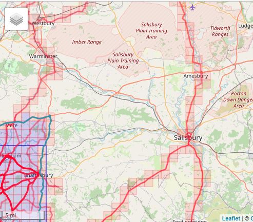
Yeah. The Imber Range and Larkhill Artillery Impact Area would tend to limit expansion in that direction. I think there are one or two "impossible" tiles in the Gunnery School Ranges at Lulworth too, although they are closer to public roads so an accidental wander onto the range when it's not in use wouldn't seem to be quite as suicidal as riding across a High Explosive artillery impact area... 
yellowjack said:
Yeah. The Imber Range and Larkhill Artillery Impact Area would tend to limit expansion in that direction. I think there are one or two "impossible" tiles in the Gunnery School Ranges at Lulworth too, although they are closer to public roads so an accidental wander onto the range when it's not in use wouldn't seem to be quite as suicidal as riding across a High Explosive artillery impact area...

On the Lulworth ranges, the blue tiles are definitely accessible by road, the orange are definitely accessible by the coast path. That final tile - there's some form of road going through it, but you might well hit a no admittance barrier, it's hard to tell.
Solocle said:
On the Lulworth ranges, the blue tiles are definitely accessible by road, the orange are definitely accessible by the coast path. That final tile - there's some form of road going through it, but you might well hit a no admittance barrier, it's hard to tell.
yellowjack said:
Looks like you have made the same assumptions as me then. Although I wasn't sure about the tile to the right of that last one. I think a "lap" of the range on a MTB is in order when the chain ferry is back up again. That way I can follow the fence line as closely as possible, and exploit any tracks I find on the way around. After all, I only need to nab a few pixels into a tile to claim it. Not a priority right now, though, as they'll do nothing to help grow my Max Square - they're too far south, below the 'base line' formed by the Bournemouth Bay sea front.
Yeah, the Bucknowle tile, Google Street View goes up to the range flag from the east. If GSV can do it, it's definitely doable on a bike! But it doesn't go beyond the flag, which I'm pretty sure could proceed past on the bike - however, you'd have to cross basically the entire tile without reaching another obstruction to nab the last one.I ticked of 9 new tiles on a ride today, and upped my max cluster to 493. Took 73km to do so though.
It should have been 11 tiles but my plan to ride through a caravan park was stymied by the whole Covid shutdown and also poor routing missing a corner by about 100m (doh).
Looking at the map I've got a 17x18 square at the moment, when I can get back out I'll try and colour in another couple of corners and hopefully increase to 18x18.
I can see this getting addictive although may end up taking the MTB to some areas by car (too far to ride there and back off road) - is that cheating?!
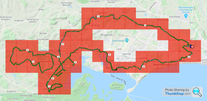
100 km and a paltry 6 tiles for me today. But to be fair they were difficult tiles around the Wareham side of Poole Harbour. Shredded legs, some "bike dumped under a tree and walk to claim the tile", and riding a road bike on what was basically a single-track footpath. Done now, though. No need to revisit any of those particular tiles.
Another 6 targeted around Arne and the Wytch Heath oil field will leave only 4 to claim on Brownsea Island. When that opens again I'll nip over on the ferry and walk the perimeter of the island to nab those. Then it's down to the south coast of Purbeck for a couple of dozen tiles. That'll need the chain ferry to open again, so that I can get across more efficiently with a MTB or gravel bike.
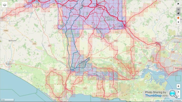
It's good fun, all this tile hunting. I think it makes sense to get some of the tougher tiles out of the way before "bulk riding" the easier ones to complete the jigsaw puzzle. No sense in setting your heart on a particular tile to extend your Max Square then getting to it to find it's surrounded by 10 ft fences (Holton Heath Cordite Factory - I'm looking at you here...). I found a way around Holton Heath in the end (which required a wee bit of trespassing if I'm honest). Once the Isle Of Purbeck is "coloured in" I'm going to have to concentrate on expanding northwards to Salisbury to start with. I'm going to ride some long routes then, to join up some of my outliers like the Imber Range Road and a group of tiles ridden from Tedworth House to Ludgershall.
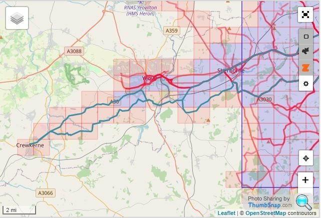
I'm also looking at routes that will join my cluster around Bournemouth to my Max Cluster set when I lived in (and centred on) Farnborough. That would mean a few long rides up to Winchester/Alresford from Bournemouth. This warm, dry weather is a real Godsend for longer cycling routes at the moment. It's almost a shame that the world is coming out of lockdown and traffic is building once again. I was quite enjoying the solitude while everyone was hunkered down at home...
Another 6 targeted around Arne and the Wytch Heath oil field will leave only 4 to claim on Brownsea Island. When that opens again I'll nip over on the ferry and walk the perimeter of the island to nab those. Then it's down to the south coast of Purbeck for a couple of dozen tiles. That'll need the chain ferry to open again, so that I can get across more efficiently with a MTB or gravel bike.
It's good fun, all this tile hunting. I think it makes sense to get some of the tougher tiles out of the way before "bulk riding" the easier ones to complete the jigsaw puzzle. No sense in setting your heart on a particular tile to extend your Max Square then getting to it to find it's surrounded by 10 ft fences (Holton Heath Cordite Factory - I'm looking at you here...). I found a way around Holton Heath in the end (which required a wee bit of trespassing if I'm honest). Once the Isle Of Purbeck is "coloured in" I'm going to have to concentrate on expanding northwards to Salisbury to start with. I'm going to ride some long routes then, to join up some of my outliers like the Imber Range Road and a group of tiles ridden from Tedworth House to Ludgershall.
I'm also looking at routes that will join my cluster around Bournemouth to my Max Cluster set when I lived in (and centred on) Farnborough. That would mean a few long rides up to Winchester/Alresford from Bournemouth. This warm, dry weather is a real Godsend for longer cycling routes at the moment. It's almost a shame that the world is coming out of lockdown and traffic is building once again. I was quite enjoying the solitude while everyone was hunkered down at home...
Yellowjack, what you really need is 2-3 rides to connect your 2 clusters to form 1 uber cluster. =)
If I manage to get my 55 miler in this week, I'll have my square nicely expanded. Managed to tick an extra bit off today, which involved hammering a set of carbon clinchers wearing 23c down several miles of off road path. Strava routes said it was a road!
I'm trying to do all of mine from home, rather than "cheating" and driving to the edge and colouring a bit in. Only exceptions will be some of the peak district hills where it's impossible to road bike up them. Hell, for some of them I don't think you're even allowed to cycle them even if you had the skill. I'll probably walk up them with the kids - but my moral compass says that's fair game.
Some Gump said:
Yellowjack, what you really need is 2-3 rides to connect your 2 clusters to form 1 uber cluster. =)
If I manage to get my 55 miler in this week, I'll have my square nicely expanded. Managed to tick an extra bit off today, which involved hammering a set of carbon clinchers wearing 23c down several miles of off road path. Strava routes said it was a road!
I'm trying to do all of mine from home, rather than "cheating" and driving to the edge and colouring a bit in. Only exceptions will be some of the peak district hills where it's impossible to road bike up them. Hell, for some of them I don't think you're even allowed to cycle them even if you had the skill. I'll probably walk up them with the kids - but my moral compass says that's fair game.
On that note...If I manage to get my 55 miler in this week, I'll have my square nicely expanded. Managed to tick an extra bit off today, which involved hammering a set of carbon clinchers wearing 23c down several miles of off road path. Strava routes said it was a road!
I'm trying to do all of mine from home, rather than "cheating" and driving to the edge and colouring a bit in. Only exceptions will be some of the peak district hills where it's impossible to road bike up them. Hell, for some of them I don't think you're even allowed to cycle them even if you had the skill. I'll probably walk up them with the kids - but my moral compass says that's fair game.
Today's ride, ticking off only six 'new' tiles.

And the two clusters that need joining, along with those outlying tiles around Tidworth and Warminster.

Gassing Station | Pedal Powered | Top of Page | What's New | My Stuff