38jl failure to pass to specified side of sign - Islington P
Discussion


I've received a penalty notice for the above code relating to a Ockendon Rd in Islington:
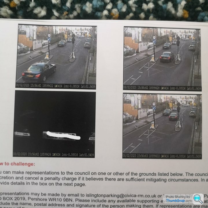
From a Google search I note that the central area was previously a raised island and that this has now been removed and instead there are really feint/worn road markings, as per the image.
Is this worth contesting?
From a Google search I note that the central area was previously a raised island and that this has now been removed and instead there are really feint/worn road markings, as per the image.
Is this worth contesting?
DanL said:
SamR380 said:
What are you contesting? The blue arrow is quite clear even if the road markings aren't.
It’s pretty clear you can’t get a car through the gap to the left of that sign... Is this road even open to cars?!Thanks for the replies.
It just seemed like a bit of a squeeze so did what I considered at the time to be the logical thing to do.
The £millions these cameras in this one borough amass is a bit of an eye opener:
https://www.islingtongazette.co.uk/news/motorists-...
If the faded central markings won't stand up as a defence I'll just pay it as I can't see any alternative.
joropug said:
What the hell even is that ? What purpose does it serve ???
That is a perfect representation of how councils work - spend lots of money to make a mess and f k up something that worked perfectly well before, then later spend more to reverse half of it, then rake some back in by penalising the people who have to navigate their way through the results.
https://www.google.com/maps/@51.5438647,-0.0849229...
Looking at google maps, the gap looks to be wider. The road has a 7'2" width restriction and a weight restriction, and it should be possible to pas on the left.
The centre gap is presumably intended to allow emergency vehicles to pass.
Looking at google maps, the gap looks to be wider. The road has a 7'2" width restriction and a weight restriction, and it should be possible to pas on the left.
The centre gap is presumably intended to allow emergency vehicles to pass.
SmoothCriminal said:
The road markings and signs make it clear the middle is not to be used so can't see what you cant fight.
Slightly confusing message but I think I know what you mean. The road markings are not clear, which I thought could act as a potential defence but I'm not sure whether there is any such precedence.
tdm34 said:
Is it me or is there a traffic cone on each payment at the narrowest part of the obstruction? certainly looks like it to me.
also it maybe something to do with lens distortion but those gaps look impossibly narrow.
Typical car hating London council...
They look like those stumpy posts that prevent bumping up the kerbs. Surely in this case (Islington are not car lovers) it's not a problem for cars but larger vehicles?also it maybe something to do with lens distortion but those gaps look impossibly narrow.
Typical car hating London council...
Graveworm said:
tdm34 said:
Is it me or is there a traffic cone on each payment at the narrowest part of the obstruction? certainly looks like it to me.
also it maybe something to do with lens distortion but those gaps look impossibly narrow.
Typical car hating London council...
They look like those stumpy posts that prevent bumping up the kerbs. Surely in this case (Islington are not car lovers) it's not a problem for cars but larger vehicles?also it maybe something to do with lens distortion but those gaps look impossibly narrow.
Typical car hating London council...
My guess would be that the intention of the width restriction would be to prevent large vehicles using residents' streets to go between the two B roads at either end of Ockendon Road while still allow refuge lorries to access the streets, there is a similar arrangement to the road to the south.
While the layout could be a little clearer, the blue arrow is quite obvious so I think it's one to chalk up I'm afraid.
While the layout could be a little clearer, the blue arrow is quite obvious so I think it's one to chalk up I'm afraid.
1Rb said:
SmoothCriminal said:
The road markings and signs make it clear the middle is not to be used so can't see what you cant fight.
Slightly confusing message but I think I know what you mean. The road markings are not clear, which I thought could act as a potential defence but I'm not sure whether there is any such precedence.
I'm talking about the white lines and hatched markings that take you to the correct side of the width restriction they're clear as day on the photo.
Gassing Station | Speed, Plod & the Law | Top of Page | What's New | My Stuff