The wet and windy, with occasional snow, 2019/2020 thread
Discussion


p1stonhead said:
PositronicRay said:
scrubchub said:
Hmm, I'd find another crossing. What is that rise like 7-8m maybe?
This picture came up on our business Twitter feed:

The main hill there, the sort of 3/4 lumps is called The Breidden and sits on the England/Wales border. (It's the further West landmark I can see from the hill I live on, about 30 plus miles away.) The main A458 to Welshpool is behind the hill, this picture, taken on the North side of the hill, facing West from Shropshire, clearly shows the B4393 disappearing under the flood of the upper Severn.
The village of Alberbury, home of the Loton Park speed hillclimb course, is just out of shot to the left.
Google maps link: https://goo.gl/maps/UdQQSdTiSPcSY7yt6
p1stonhead said:
scrubchub said:
p1stonhead said:
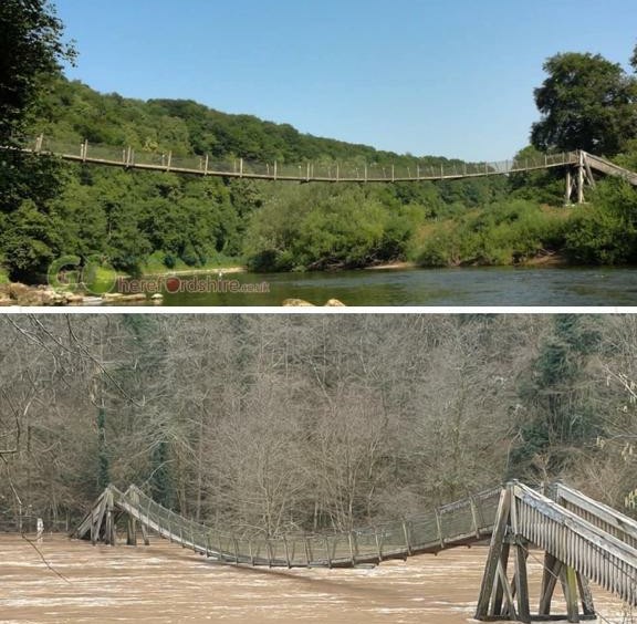
Most insane photo I’ve seen on these floods I reckon.
What is that rise like 7-8m maybe?
It is measured in Monmouth at 7.2m so I'd say you were bang on. What is that rise like 7-8m maybe?
CTO said:
FiF said:
I should say this unbelievable but sadly it's just par for the course these days.
Rubberneckers in Bewdley are not only getting in the way of evacuations and other work but have moved safety barriers so they can get a better view when the river tops the flood barriers.
Now looking as if may get away with it tonight. Touch and go tomorrow morning though.
Are you in Bewdley? You're very accurate Rubberneckers in Bewdley are not only getting in the way of evacuations and other work but have moved safety barriers so they can get a better view when the river tops the flood barriers.
Now looking as if may get away with it tonight. Touch and go tomorrow morning though.

Yup, morons have decided to move closer to get a good look at their impending death...
Marginally beaten by the t
 ts on Sunday who moved the barriers so they could park closer to the river... which then meant the lorry delivering flood barriers by our house couldn't get through......
Yep, nice one, d
heads.Iron bridge is also really high and Upper Arley it’s about 5 foot under the foot bridge and over the car parks.
Watched the facebook groups last night and this morning as it was very close to the barriers.
Still nice to see the chippy open and people eating outside.
Assume Bewdley Sports club is underwater at the end of Stourport Road ?


scrubchub said:
Looking at the forecast for Gloucestershire and it seems that it may be coming to an end after this band of rain. Hopefully, and good riddance. Really need spring to get a move on.
Edit - and then I saw the post above. Spoke too soon.
Problem for Gloucestershire is quite how far downstream it is from the source of the Severn. The route of the Severn is, frankly, mad, freakish even. 220 miles long.Edit - and then I saw the post above. Spoke too soon.
Dark blue line is Severn and lighter blue lines are tributaries:

Going on what some people have mentioned about rivers and streams being blocked by trees and debris ect is really bang on. I work for a water company and inv pollutions ect so spend a lot of time in watercourses of all sizes and all I’m seeing is flow making its own way wherever is possible.
I’ll look at mapping and compare the difference and it’s sometimes astonishing how far off it is due to it not being able to flow in its usual course.
Trees big and small and so much debris blocking and restricting is a real issue. Not to mention the wonderful human element of putting whatever we want into it. Oil drums tyres and concrete is still the most common thing I see.
warch said:
In the end though it doesn’t matter how open and unrestricted the waterways are, if you have a month and a half’s worth of rainfall overnight, as mid Wales experienced last Saturday.
In Engineering terms, relieving flooding on the upper or middle Severn is incredibly difficult. You'd really need to create huge storm water reservoirs and I'm not sure where you'd locate them.Gassing Station | The Lounge | Top of Page | What's New | My Stuff