
Bristol airport
Discussion


Im sat in the departure lounge at bristol airport looking out over the runway so not sure what direction the runway is but everything is taking off/landing left to right as you look at it from the terminal building.
Now my question to anybody that knows this airport is the runway on a slight down hill angle or is the area where the planes park up on an angle?
As they take off/land they are going down behind a slight hill but cant workout where the slope is.
Random I know but my flight is at 21:40 and ive been here since 17:45 so rather bored now!.
Now my question to anybody that knows this airport is the runway on a slight down hill angle or is the area where the planes park up on an angle?
As they take off/land they are going down behind a slight hill but cant workout where the slope is.
Random I know but my flight is at 21:40 and ive been here since 17:45 so rather bored now!.
The runway is 09/27 ie east/west
At the threshold of 09 ie heading east on landing there is a fair downhill slope about a third in from that threshold. It's not the longest runway around, quite from it, so on the bigger jets, you really want to get it down before the runway drops out from underneath you.
Sounds like tonight, from what you say, they are on 27.
HTH
At the threshold of 09 ie heading east on landing there is a fair downhill slope about a third in from that threshold. It's not the longest runway around, quite from it, so on the bigger jets, you really want to get it down before the runway drops out from underneath you.
Sounds like tonight, from what you say, they are on 27.
HTH
Assuming you're in one of the terminals on the North side of the airport:
The runway threshold on your left is Runway 27 (east side of the airport and nearer to you I think). From what you describe, this is the runway threshold that aircraft are landing on and departing from.
The runway threshold on your right is Runway 09.
The R09 threshold (613 feet) is 12 feet higher than the R27 threshold (601 feet). So an overall slope of 0.15% downhill on R09/uphill on R27.
But the runway also has a hump in it on your right hand side, towards the R09 threshold, with a maximum elevation of 622 feet.
So what you're probably seeing is aircraft on R27 going uphill to the hump and then downhill again (but still higher than before the hump).
The OS map of the airport shows some other bumps within the airport perimeter and the difference in gradient of them compared with the runway might also trick the eye too (like ' magic roads')
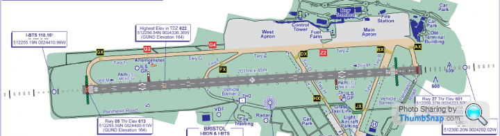
The runway threshold on your left is Runway 27 (east side of the airport and nearer to you I think). From what you describe, this is the runway threshold that aircraft are landing on and departing from.
The runway threshold on your right is Runway 09.
The R09 threshold (613 feet) is 12 feet higher than the R27 threshold (601 feet). So an overall slope of 0.15% downhill on R09/uphill on R27.
But the runway also has a hump in it on your right hand side, towards the R09 threshold, with a maximum elevation of 622 feet.
So what you're probably seeing is aircraft on R27 going uphill to the hump and then downhill again (but still higher than before the hump).
The OS map of the airport shows some other bumps within the airport perimeter and the difference in gradient of them compared with the runway might also trick the eye too (like ' magic roads')
UK Aeronautical Information Publication said:
Pilots should note that when using Runway 09, there is a 240m area of the runway that provides a forward sight distance of less than 1006m (for an eye height of 3m above the runway surface) between the start of the LDA (Landing Distance Available) and 240m after the start of the LDA located in the area of the Runway 09 threshold and start of 09 TDZ (Touch Down Zone).
Pilots should note that when using Runway 27, there is a 395m area of the runway that provides a forward sight distance of less than 1006m (for an eye height of 3m above the runway surface) between 630m and 1025m after the start of the LDA located in the middle of the runway length.
Pilots should note that when using Runway 27, there is a 395m area of the runway that provides a forward sight distance of less than 1006m (for an eye height of 3m above the runway surface) between 630m and 1025m after the start of the LDA located in the middle of the runway length.
From where you were sat looking out, the apron has a slight run uphill looking south, and that part of the runway is at its lowest so it looks like the planes disappear in to ground.
Pilots day it's one of the most challenging places to land and hate it, but I have also seen some find it to taxi due to the hump in the taxi way opposite the fuel farm, I've seen a few out of base aircraft come to that point with no power and roll back!
Pilots day it's one of the most challenging places to land and hate it, but I have also seen some find it to taxi due to the hump in the taxi way opposite the fuel farm, I've seen a few out of base aircraft come to that point with no power and roll back!
Close to Bristol are/were two airfields.
One has a runway so long and wide you can launch or recover literally anything on it, where aircraft can climb into the westerly prevailing wind over open country then the Bristol Channel, and which is literally right on top of a railway line connecting with the nearby main London Cardiff line, and very close to the M5 and M4 interchange.
The other is on top of a hill renowned for its changeable, inclement weather, in the past used by the RAF to practice bad weather landings. The runway goes up and down, is fairly short and cannot be extended - at one end is protected land and at the other end is a precipice. The motorway and rail network pass nowhere near.
Guess which one our illustrious local authorities decided to develop as the regional hub.
One has a runway so long and wide you can launch or recover literally anything on it, where aircraft can climb into the westerly prevailing wind over open country then the Bristol Channel, and which is literally right on top of a railway line connecting with the nearby main London Cardiff line, and very close to the M5 and M4 interchange.
The other is on top of a hill renowned for its changeable, inclement weather, in the past used by the RAF to practice bad weather landings. The runway goes up and down, is fairly short and cannot be extended - at one end is protected land and at the other end is a precipice. The motorway and rail network pass nowhere near.
Guess which one our illustrious local authorities decided to develop as the regional hub.
Yertis said:
Close to Bristol are/were two airfields.
One has a runway so long and wide you can launch or recover literally anything on it,
The other is on top of a hill renowned for its changeable, inclement weather,.
Guess which one our illustrious local authorities decided to develop as the regional hub.
not this one thenOne has a runway so long and wide you can launch or recover literally anything on it,
The other is on top of a hill renowned for its changeable, inclement weather,.
Guess which one our illustrious local authorities decided to develop as the regional hub.
https://maps.google.co.uk/maps?q=filton&hl=en&...

Yertis said:
Close to Bristol are/were two airfields.
One has a runway so long and wide you can launch or recover literally anything on it, where aircraft can climb into the westerly prevailing wind over open country then the Bristol Channel, and which is literally right on top of a railway line connecting with the nearby main London Cardiff line, and very close to the M5 and M4 interchange.
The other is on top of a hill renowned for its changeable, inclement weather, in the past used by the RAF to practice bad weather landings. The runway goes up and down, is fairly short and cannot be extended - at one end is protected land and at the other end is a precipice. The motorway and rail network pass nowhere near.
Guess which one our illustrious local authorities decided to develop as the regional hub.
A decision I've often pondered when choosing not to use Bristol, despite it being my closest airport, 'cos it's such a PITA to get to.One has a runway so long and wide you can launch or recover literally anything on it, where aircraft can climb into the westerly prevailing wind over open country then the Bristol Channel, and which is literally right on top of a railway line connecting with the nearby main London Cardiff line, and very close to the M5 and M4 interchange.
The other is on top of a hill renowned for its changeable, inclement weather, in the past used by the RAF to practice bad weather landings. The runway goes up and down, is fairly short and cannot be extended - at one end is protected land and at the other end is a precipice. The motorway and rail network pass nowhere near.
Guess which one our illustrious local authorities decided to develop as the regional hub.
Any idea what lay behind the original decision?
thismonkeyhere said:
Yertis said:
Close to Bristol are/were two airfields.
One has a runway so long and wide you can launch or recover literally anything on it, where aircraft can climb into the westerly prevailing wind over open country then the Bristol Channel, and which is literally right on top of a railway line connecting with the nearby main London Cardiff line, and very close to the M5 and M4 interchange.
The other is on top of a hill renowned for its changeable, inclement weather, in the past used by the RAF to practice bad weather landings. The runway goes up and down, is fairly short and cannot be extended - at one end is protected land and at the other end is a precipice. The motorway and rail network pass nowhere near.
Guess which one our illustrious local authorities decided to develop as the regional hub.
A decision I've often pondered when choosing not to use Bristol, despite it being my closest airport, 'cos it's such a PITA to get to.One has a runway so long and wide you can launch or recover literally anything on it, where aircraft can climb into the westerly prevailing wind over open country then the Bristol Channel, and which is literally right on top of a railway line connecting with the nearby main London Cardiff line, and very close to the M5 and M4 interchange.
The other is on top of a hill renowned for its changeable, inclement weather, in the past used by the RAF to practice bad weather landings. The runway goes up and down, is fairly short and cannot be extended - at one end is protected land and at the other end is a precipice. The motorway and rail network pass nowhere near.
Guess which one our illustrious local authorities decided to develop as the regional hub.
Any idea what lay behind the original decision?

Gassing Station | Boats, Planes & Trains | Top of Page | What's New | My Stuff