Strange flight path, or not?
Discussion


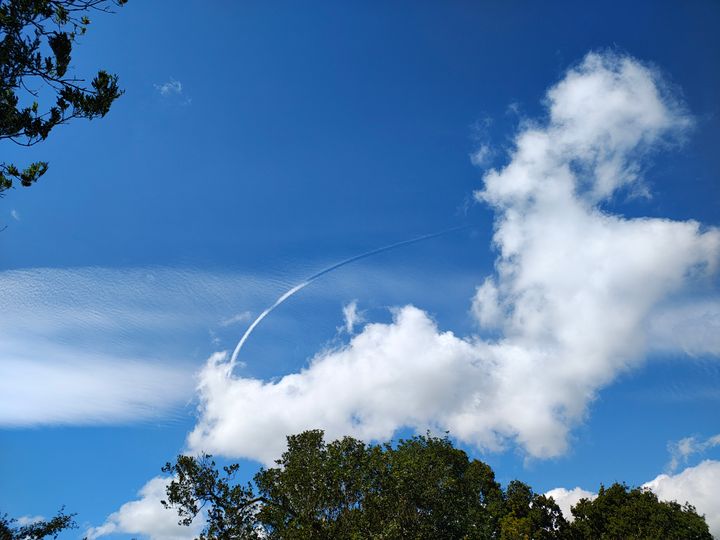
We were out for a walk the other day and I spotted this trail in the sky. It looked quite a sharp turn for an aircraft. If you zoom in, you can see the line clearer. We're about 10 miles due south of Manchester Airport but if the plane was going there I would have expected the trail to be much lower. Any ideas?
maccboy said:
We were out for a walk the other day and I spotted this trail in the sky. It looked quite a sharp turn for an aircraft. If you zoom in, you can see the line clearer. We're about 10 miles due south of Manchester Airport but if the plane was going there I would have expected the trail to be much lower. Any ideas?
If you can narrow it down to where and when then Flightradar24 playback might identify it.Looks like a rate 1 turn. Were you anywhere near the DAYNE holding point? https://opennav.com/pdf/EGCC/EG_AD_2_EGCC_7-6_en_2...
As for height in the holding stack, see page 4 here
As for height in the holding stack, see page 4 here
Edited by mikef on Wednesday 6th August 21:31
Interesting. I'll check the coordinates. We were near Bidlea. Not sure if that's in that area.
https://maps.app.goo.gl/WWNt8ms6zvVKBz8u8?g_st=ac
https://maps.app.goo.gl/WWNt8ms6zvVKBz8u8?g_st=ac
maccboy said:
Interesting. I'll check the coordinates. We were near Bidlea. Not sure if that's in that area.
https://maps.app.goo.gl/WWNt8ms6zvVKBz8u8?g_st=ac
Yes, that looks to be right under the green curved lines illustrated for leaving the DAYNE stack for an easterly approach to EGCC r/w 05L/R (see ]page 4 here)https://maps.app.goo.gl/WWNt8ms6zvVKBz8u8?g_st=ac
Gassing Station | Boats, Planes & Trains | Top of Page | What's New | My Stuff