Identify Old Building Type From OS Map?
Discussion


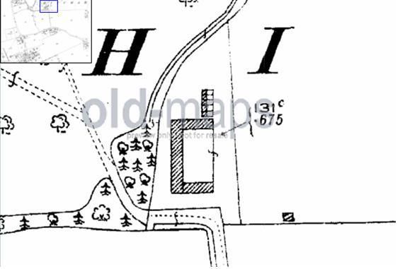
I'm trying to do some research on a plot of land near me - is anyone able to identify what kind of building is in the map below? It's a U shape, and was built sometime between 1880-1930! Is it likely to just have been a barn or could it have been a farmhouse dwelling? It was still there in 1994, but has since been knocked down and replaced with modern farm buildings.
Cheers!
Dom
Cheers!
Dom
Zeemax_Mini said:
SL60HG!
Dom
That '!' will be a '1' then? Dom

Not sure what the 'U' shaped building could be but those smaller ones just to the north are intriguing. If the depiction is accurate perhaps workers cottages with small gardens? If they are and the scale is correct then the 'U' shaped building could have been a large house. Would it have been demolished and built over though?
Rather than the postcode (SL60HG1 isn't a real one) would you know the lat/long?
Edited by Flintstone on Monday 25th April 12:04
[quote=Flintstone]Not sure what the 'U' shaped building could be but those smaller ones just to the north are intriguing. If the depiction is accurate perhaps workers cottages with small gardens? If they are and the scale is correct then the 'U' shaped building could have been a large house. Would it have been demolished and built over though?
Rather than the postcode (SL60HG1 isn't a real one) would you know the lat/long?/quote]
SL6 0HG is the post code - no 1 on the end! That's my thinking though - if it had been a house, I can't imagine it would have been knocked down and replaced with farm storage buildings!
Miniman - that map shows it how it is today, with the U building gone (around 1993 I think).
Trying to work it out as I assume if it was some kind of dwelling that planning on the site might be more likely (green belt) - it'd be my perfect plot!
Dom
If you look on this site..
https://ubp.buckscc.gov.uk/Map.aspx?selection=all
and use the map (not sure that link will show the zoomed area) it shows that block as "Hitchambury Farm" So it was certainly linked to the manor house, and could well have been a farmhouse and associated out-buildings.
You can see it on the far left of this map..
http://www.lgbce.org.uk/documents/lgbce-documents/all-reviews/south-east/buckinghamshire/south-buckinghamshire/south-bucks-map-a02_5277-4881__e.pdf
Edited by Nuisance_Value on Monday 25th April 12:41
Nuisance_Value said:
If you look on this site..
https://ubp.buckscc.gov.uk/Map.aspx?selection=all
and use the map (not sure that link will show the zoomed area) it shows that block as "Hitchambury Farm" So it was certainly linked to the manor house, and could well have been a farmhouse and associated out-buildings.
Thanks for that - I had found the name "Hitachmbury Farm" but can find no reference to it through Google etc, nor through the SouthBucks planning portal (for previous applications etc). I'll give the planning department a ring tommorow, but I'd imagine if there had been a farmhouse there before that getting planning in a greenbelt area would be easier? Probably not much chance if it's just been used for farm buildings - is that right?https://ubp.buckscc.gov.uk/Map.aspx?selection=all
and use the map (not sure that link will show the zoomed area) it shows that block as "Hitchambury Farm" So it was certainly linked to the manor house, and could well have been a farmhouse and associated out-buildings.
Cheers,
Dom
From Google maps:
http://maps.google.co.uk/maps?f=q&source=s_q&a...
It appears that the existing barns are to the East of the location of the U shaped structure that you are enquiring about.
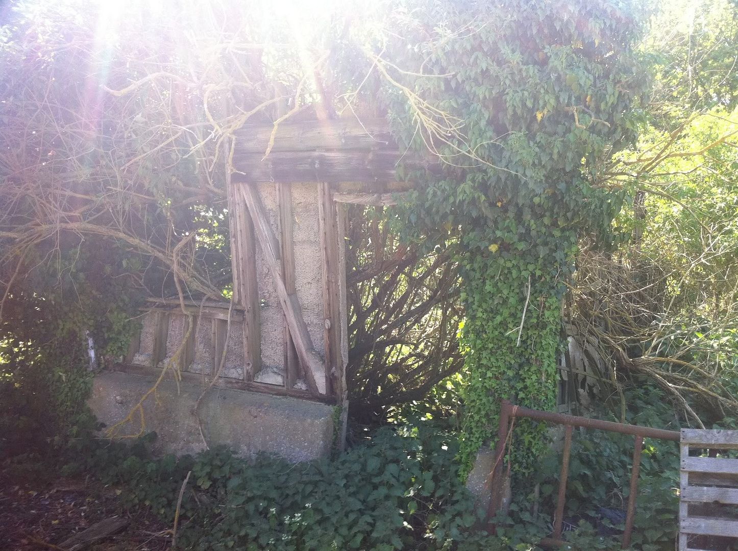
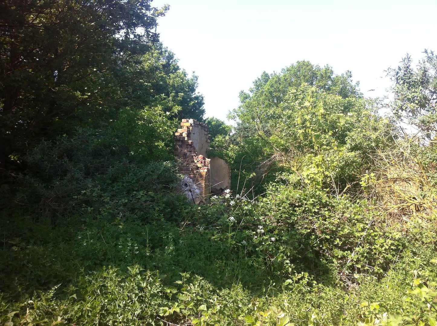
From the aerial photo, that building is now missing/completely overgrown. If you can get access for a look-see in amongst the greenery, you would be able to see if there were any remains to give you a clue.
If you can't get permission, looks like you have to lose a ball playing golf!
http://maps.google.co.uk/maps?f=q&source=s_q&a...
It appears that the existing barns are to the East of the location of the U shaped structure that you are enquiring about.
From the aerial photo, that building is now missing/completely overgrown. If you can get access for a look-see in amongst the greenery, you would be able to see if there were any remains to give you a clue.
If you can't get permission, looks like you have to lose a ball playing golf!
Try contacting your local branch of the Valuation Office Agency. They have hand drawn surveys of just about everything that can either have a rateable value or council tax band slapped on it. Including stuff that's been torn down. May be worth a call.
www.voa.gov.uk
www.voa.gov.uk
Old aerial photos
see here for late '40's aerial photo of it, unfortunately a bit small on the 'net, but it's there.
http://www.ukaerialphotos.com/viewer.asp?x=491453&...
see here for late '40's aerial photo of it, unfortunately a bit small on the 'net, but it's there.
http://www.ukaerialphotos.com/viewer.asp?x=491453&...
Gassing Station | Homes, Gardens and DIY | Top of Page | What's New | My Stuff