Climbing Ben Nevis
Discussion


Considering going to Scotland in late May/early June. Have been many times before & often thought that I’d like to go up Ben Nevis.
I’m not a climber, but walk regularly & covering up to 15 miles a day wouldn’t be an issue - could do more, but haven’t.
Providing the weather is favourable, how difficult/dangerous is it? Is it achievable for someone like myself, who isn’t experienced?
Thanks
I’m not a climber, but walk regularly & covering up to 15 miles a day wouldn’t be an issue - could do more, but haven’t.
Providing the weather is favourable, how difficult/dangerous is it? Is it achievable for someone like myself, who isn’t experienced?
Thanks
If you are using the usual tourist track from Glen Nevis, then it's not technically hard, just a bit of a slog. On a nice day, good forecast, it is just a long day out with no objective hazards.
However, I would make a note of the bearing you may need if you hit the summit and it clags or storms out, especially if it still has snow sitting on the top (it still can well into May)
Checking my guide, the bearing from the summit station is
"GRID bearing of 231° and follow it for 150m then GRID bearing of 282°"
The map should have an inset (or it used to do) with the bearing from the summit shelter to the top of the tourist (Red Burn) path. Get it wrong and you'll end up in five Finger Gully or Gardyloo Gully, which will spoil your day a touch!
I wouldn't try come up the north side, it's exposed, craggy, technical and greasy and often still has snow on it and in it that time of year, plus it's a fooking long boring boggy walk
Caveat, there are more people experienced than me.
I first hiked Ben Nevis in my late 20 s. The last time was a couple of years aged 59.
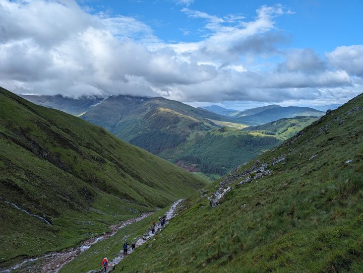
The easiest route is up/down from Visitor Centre in Glen Nevis. It s about a 10 miles round trip and can take 6-8hrs. It s a bit of a slog but the views can be stunning.
The last time I did it the sun was out and we began in t-shirt and shorts. Many others did similar but in trainers and sandles! This was around 1st July.
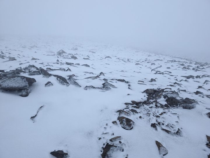
A third of the way up the rain began, past half-way we had horizontal hail, and at the top very windy freezing conditions with snow remaining. We had all the kit required for all of those conditions and enough supplies/water for 8 hours.
Near the top it s very important to follow the path marked by mounds of stones. If you veer off you re facing a 2000ft drop and people do fall off! In May/June it s likely that there will still be a lot of snow near the top. The snow often overhangs the edge of the mountain, so please don t go and look over the edge as you might literally be standing on only pile of snow with a massive drop below.
The old path up to about the half-way point has now been replaced by big stones and boulders which makes it very slippy in wet conditions. I found this slowed me down on the decent.
Make sure you have a GPS, or a map and compass, and know how to use them. You probably won t need them as the path is well defined but it s not worth the risk if visibility deteriorates.
Good footwear, plenty of layers, gloves, hat, and full waterproof clothing is essential in all weathers. Edited to say I find poles essential particularly for the decent.
This was me near the top on a warm summers day
I first hiked Ben Nevis in my late 20 s. The last time was a couple of years aged 59.
The easiest route is up/down from Visitor Centre in Glen Nevis. It s about a 10 miles round trip and can take 6-8hrs. It s a bit of a slog but the views can be stunning.
The last time I did it the sun was out and we began in t-shirt and shorts. Many others did similar but in trainers and sandles! This was around 1st July.
A third of the way up the rain began, past half-way we had horizontal hail, and at the top very windy freezing conditions with snow remaining. We had all the kit required for all of those conditions and enough supplies/water for 8 hours.
Near the top it s very important to follow the path marked by mounds of stones. If you veer off you re facing a 2000ft drop and people do fall off! In May/June it s likely that there will still be a lot of snow near the top. The snow often overhangs the edge of the mountain, so please don t go and look over the edge as you might literally be standing on only pile of snow with a massive drop below.
The old path up to about the half-way point has now been replaced by big stones and boulders which makes it very slippy in wet conditions. I found this slowed me down on the decent.
Make sure you have a GPS, or a map and compass, and know how to use them. You probably won t need them as the path is well defined but it s not worth the risk if visibility deteriorates.
Good footwear, plenty of layers, gloves, hat, and full waterproof clothing is essential in all weathers. Edited to say I find poles essential particularly for the decent.
This was me near the top on a warm summers day
Edited by Phil. on Wednesday 25th February 17:20
Castrol for a knave said:
However, I would make a note of the bearing you may need if you hit the summit and it clags or storms out, especially if it still has snow sitting on the top (it still can well into May)
Checking my guide, the bearing from the summit station is
"GRID bearing of 231° and follow it for 150m then GRID bearing of 282°"
The map should have an inset (or it used to do) with the bearing from the summit shelter to the top of the tourist (Red Burn) path. Get it wrong and you'll end up in five Finger Gully or Gardyloo Gully, which will spoil your day a touch!
This. It's an easy enough walk if you're used to it but has potential to be a bugger.Checking my guide, the bearing from the summit station is
"GRID bearing of 231° and follow it for 150m then GRID bearing of 282°"
The map should have an inset (or it used to do) with the bearing from the summit shelter to the top of the tourist (Red Burn) path. Get it wrong and you'll end up in five Finger Gully or Gardyloo Gully, which will spoil your day a touch!
Although now you know this you're probably better prepared than the vast majority who do it!
Brinyan said:
Considering going to Scotland in late May/early June. Have been many times before & often thought that I d like to go up Ben Nevis.
I m not a climber, but walk regularly & covering up to 15 miles a day wouldn t be an issue - could do more, but haven t.
Providing the weather is favourable, how difficult/dangerous is it? Is it achievable for someone like myself, who isn t experienced?
Thanks
Stick to the main track up from glen Nevis and it's easy to navigate. The track is well walked. It's a stunning walk if the weather is good. I m not a climber, but walk regularly & covering up to 15 miles a day wouldn t be an issue - could do more, but haven t.
Providing the weather is favourable, how difficult/dangerous is it? Is it achievable for someone like myself, who isn t experienced?
Thanks
If visibility at the top is poor then be very careful.
Edited by thebraketester on Wednesday 25th February 18:00
Edited by thebraketester on Wednesday 25th February 18:05
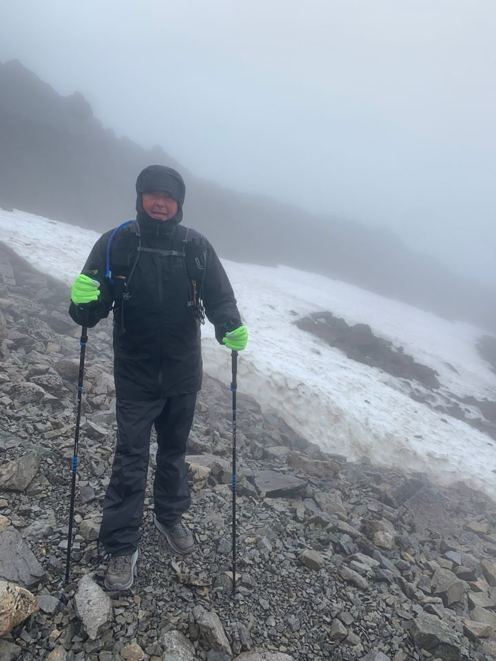
Another +1 for planning sensibly for bad weather. We went up on the tourist route in early June 2024 and started with a sunny day. By 80% up, it was sideways blizzard and over a foot of snow. Visibility was atrocious at times and there were a lot of poorly equipped people struggling or turning back.
It is a slog. Wear good, high boots that give ankle support; the path becomes fairly rough and loose under foot towards the top, especially on the zig zags. We saw someone get quite dramatically airlifted off the side of the mountain due to injury on the lower, better laid path.
All of that said, if you are fit, do your research and take some precautions then I think it is accessible to a relative novice. We did some practice climbs earlier that year up Sugarloaf and Pen y Fan, ot get familiar with our gear and work out what we were missing. I can recommend this!
Here is the change in weather on our climb!
Edited by Simbu on Wednesday 25th February 20:03
We did the tourist path, as complete novices but fit compared to average. I wore trainers, seem to remember it was fine.
Found it harder on the legs coming back down.
If you have a pair of walking boots and a rucksack with coat and a decent amount of water you'll be better prepared than most. As we were coming down in late afternoon we passed loads of people near the bottom walking up dressed for popping to the shop in summer, but no idea if they were intending to summit or not.
If you’re sensible and can navigate then the CMD Arête route is the most fun ‘walking’ route up Ben Nevis. It’s a grade 1 scramble but not scary or exposed if done correctly. Do some research and see if it’s for you. It’s about 50 times nicer than the tourist track, but a big day with the need to be confident in the hills.
If (having googled e.g., walkhighlands) you decide it’s not for you, follow your head. But at least you’ll know about it if you ever decide to come back and have another go.
If (having googled e.g., walkhighlands) you decide it’s not for you, follow your head. But at least you’ll know about it if you ever decide to come back and have another go.
Brinyan said:
I'm not a climber, but walk regularly & covering up to 15 miles a day wouldn t be an issue - could do more, but haven t.
Miles on the flat are very different to miles in the hills. Get as much hill work in as you can, and remember most accident happen when descending... Tired, darkness, etc.silentbrown said:
Brinyan said:
I'm not a climber, but walk regularly & covering up to 15 miles a day wouldn t be an issue - could do more, but haven t.
Miles on the flat are very different to miles in the hills. Get as much hill work in as you can, and remember most accident happen when descending... Tired, darkness, etc.

hidetheelephants said:
IIRC Naismith says allow an hour per 2000 feet climbed for planning, but I'm a fat sedentary middle-aged person so I allow 1 hr per 1000'.
 Approx 1 minute per 10m of elevation gain. Added to the time for distance travelled.
 It's a starting point, and you'll find your own "rule".

Did it a couple of years ago, first leg of the 3 Peaks Challenge. Second week in September, started the walk at 1pm in 25 degree heat! In perfect cloudless conditions, the path was easy going, less challenging than the Miners/Pyg tracks up Snowdon, but it's a long old slog. Obviously it isn't as easy in poor weather.
Gassing Station | Holidays & Travel | Top of Page | What's New | My Stuff