
What do we think this chap was doing during the night?
Author
Discussion

HoHoHo

Original Poster:

15,398 posts

279 months

Sunday 1st March 2015
quotequote all
Once I'm awake I'm awake (years of running a business I guess) and of course like any other plane sado I tend to have a glance at flight radar during the night to see what's around.

So at 4am when I looked, this chap had been flying around nearby clearly in an organised fashion for some time.....
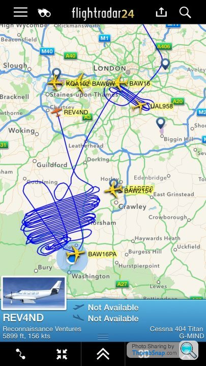


Your guess is as good as mine, perhaps he was looking for squirrels wink

Ilovejapcrap

3,311 posts

141 months

Sunday 1st March 2015
quotequote all
I know nothing about planes is this like going for a drive or do you have to have a route to go up ?

wijit

1,512 posts

204 months

Sunday 1st March 2015
quotequote all
I know even less than the above, but could it be one of those "Google" things, or the like?

51mes

1,557 posts

229 months

Sunday 1st March 2015
quotequote all
Well looking who own the plane...

http://www.rvl-group.com/about-us/

nice regular pattern - some kind of survey but in the dark so radar, IR or something - looking for pot farms, the mind boggles...

S.

Some Gump

13,018 posts

215 months

Sunday 1st March 2015
quotequote all
called reconnisance ventures?
flying in lines?

My guess is aerial photographer.

mph1977

12,467 posts

197 months

Sunday 1st March 2015
quotequote all
Some Gump said:
called reconnisance ventures?
flying in lines?

My guess is aerial photographer.
but at 4 am in March ?

ecsrobin

18,643 posts

194 months

Sunday 1st March 2015
quotequote all
The aircraft has a LIDAR sensor fitted which is used for terrain mapping and elevation data.

The end product would be something like this:


My guess is because it's near gatwicks airspace this was the only time suitable to do the work.

mph1977

12,467 posts

197 months

Sunday 1st March 2015
quotequote all
ecsrobin said:
The aircraft has a LIDAR sensor fitted which is used for terrain mapping and elevation data.

The end product would be something like this:


My guess is because it's near gatwicks airspace this was the only time suitable to do the work.
fair enough

Boatbuoy

1,975 posts

191 months

Sunday 1st March 2015
quotequote all
I'm going to guess at Laser Mapping. The Aircraft in question (according to the image on their website) is liveried in Ordinance Survey colours. My theory is that laser scanning doesn't require daylight, and they are taking advantage of quiet airspace in and around London at that time.

Ilovejapcrap

3,311 posts

141 months

Sunday 1st March 2015
quotequote all
Or he was lost

Lotus 50

1,029 posts

194 months

Monday 2nd March 2015
quotequote all
Probably doing LiDAR survey work for the Environment Agency (they do lots of this to develop digital terrain maps for use in flood risk management work).

Simpo Two

92,670 posts

294 months

Monday 2nd March 2015
quotequote all
Russian Bear dropping Window as decoy for invasion...

fomb

1,405 posts

240 months

Monday 2nd March 2015
quotequote all
Lotus 50 said:
Probably doing LiDAR survey work for the Environment Agency (they do lots of this to develop digital terrain maps for use in flood risk management work).
http://www.planepictures.net/netshow.php?id=699491

Crumpet

5,373 posts

209 months

Monday 2nd March 2015
quotequote all
Yep, aerial survey. I used to have hours of fun doing it! As mentioned above it will probably be Lidar, although at one point the company I worked for had a thermal imaging camera, so that could be an option.

It was like mowing a lawn in the sky!

Prawo Jazdy

5,037 posts

243 months

Monday 2nd March 2015
quotequote all
Unsurprisingly, they use the call sign "Endurance" cool .

RobbyJ

1,824 posts

251 months

Tuesday 3rd March 2015
quotequote all
It was probably a less eventful night out for that aircraft than this one was:

http://www.aaib.gov.uk/cms_resources.cfm?file=/Ces...

mrloudly

2,815 posts

264 months

Tuesday 3rd March 2015
quotequote all
Had a brilliant trip in a Piper Chieftain once G-NERC (National Environmental Research Council) ((Reg now moved)) We did similar taken hundreds of pic's off of the Gower Peninsula. The photography bit was boring, the flight home at
a very low altitude through the Malvern hills wasn't biggrin

Chucklehead

2,853 posts

237 months

Tuesday 3rd March 2015
quotequote all
Building a case for a second runway ;-)

LHRFlightman

2,246 posts

199 months

Tuesday 3rd March 2015
quotequote all
Aerial survey flight. I've seen lots of these in my system at work.

Pot Bellied Fool

2,260 posts

266 months

Friday 6th March 2015
quotequote all
Crumpet said:
Yep, aerial survey. I used to have hours of fun doing it! As mentioned above it will probably be Lidar, although at one point the company I worked for had a thermal imaging camera, so that could be an option.

It was like mowing a lawn in the sky!
smile Who were you with Crumpet? I used to specialise in aerial thermographic surveys (Using the venerable but lovely IR189400) and had many fun hours in the back of Queenairs, Aztecs & Aerocommanders.

As others have said, that's a tpical aerial survey racetrack pattern. We used to fly at 2000ft agl, tracks seperated by 300M iirc. I've even been mistaken for a UFO!

Done at night time for ease of access and in the case of thermal, to avoid solar gain.

Loved my time doing that sort of work but sold my kit off to a German outfit as I was being split in too many directions.