Calling anyone that lives/d in Rawdon, Yorkshire
Discussion


How would I find the physical location of a house that I think doesn't exist anymore?
So about 1961 I spent the winter at "Alderley", Emmot Drive, Rawdon and remember playing in the icy stream nearby. It was so cold that we couldn't get the car up the steep driveway. The house had a great view over the valley.
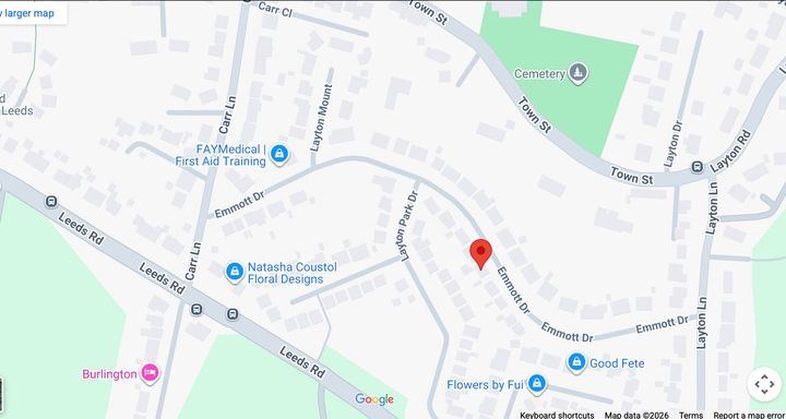
This last summer I walked up and down that street to no avail. I could not find the house. I asked the local postman who hadn't heard of it. I checked on Google maps and could not find it.
What do I do next? I would really like a photo for my album of all the places that I lived. I'm up to about 25 places now.
So about 1961 I spent the winter at "Alderley", Emmot Drive, Rawdon and remember playing in the icy stream nearby. It was so cold that we couldn't get the car up the steep driveway. The house had a great view over the valley.
This last summer I walked up and down that street to no avail. I could not find the house. I asked the local postman who hadn't heard of it. I checked on Google maps and could not find it.
What do I do next? I would really like a photo for my album of all the places that I lived. I'm up to about 25 places now.
paul.deitch said:
How would I find the physical location of a house that I think doesn't exist anymore?
So about 1961 I spent the winter at "Alderley", Emmot Drive, Rawdon and remember playing in the icy stream nearby. It was so cold that we couldn't get the car up the steep driveway. The house had a great view over the valley.
This last summer I walked up and down that street to no avail. I could not find the house. I asked the local postman who hadn't heard of it. I checked on Google maps and could not find it.
What do I do next? I would really like a photo for my album of all the places that I lived. I'm up to about 25 places now.
Might be barking up the wrong tree, as it's on a different road, but could it be this?So about 1961 I spent the winter at "Alderley", Emmot Drive, Rawdon and remember playing in the icy stream nearby. It was so cold that we couldn't get the car up the steep driveway. The house had a great view over the valley.
This last summer I walked up and down that street to no avail. I could not find the house. I asked the local postman who hadn't heard of it. I checked on Google maps and could not find it.
What do I do next? I would really like a photo for my album of all the places that I lived. I'm up to about 25 places now.
Apperley Grange
Try the maps here https://maps.nls.uk/os/ as they have sets of old and large scale ones, very useful for looking at historical property locations.
I had a quick look and the 1:1250 series surveyed in 1961 looks promising, but typically the bit you're after is on a sheet corner so you need to look at 4.
I also think there's more than one set as there seems to be an 'A' set with the road not complete and with house names, and another 'B' set with a through road and different houses? Bit confusing.
Easiest way to access is to set the map set/scale/date you're after and choose off the map.
I also think there's more than one set as there seems to be an 'A' set with the road not complete and with house names, and another 'B' set with a through road and different houses? Bit confusing.
Easiest way to access is to set the map set/scale/date you're after and choose off the map.
Some old maps are here.
https://maps.nls.uk/os/national-grid/sc-sh.html
The numbers relate to grid reference, SE, SW, NE, NW around the grid reference and the A/B/C is time related.
Have a look at SE2239 and work around from there. Most of the houses on the Leeds Planning Portal look like they have been there since pre-75 (as far back as it goes). The maps suggest most of the houses were already there in 1961 apart from a few that look like the split the gardens to build later.
Found a reference to it!
Ancestry
And I think the road is on the very right hand side of this image, but I don't know which house it might be.
Historic England photo
Best of luck!
Ancestry
And I think the road is on the very right hand side of this image, but I don't know which house it might be.
Historic England photo
Best of luck!
Hah! Thanks. Yes Violet was my step-gm's sister. It's a long story and not for publication but that side of the family "cheated" us out of a large inheritance - 4 houses in a tourist area. Still, life has been good to me but if my wife died I would never marry again and potentially risk signing away my children's inheritance. A pox on that family.

I had a look on a mapping and reporting tool that is nationwide and shows property names. No luck in finding Alverley even in surrounding district, but image below showing a zoomed in part which at least shows some sort of stream.
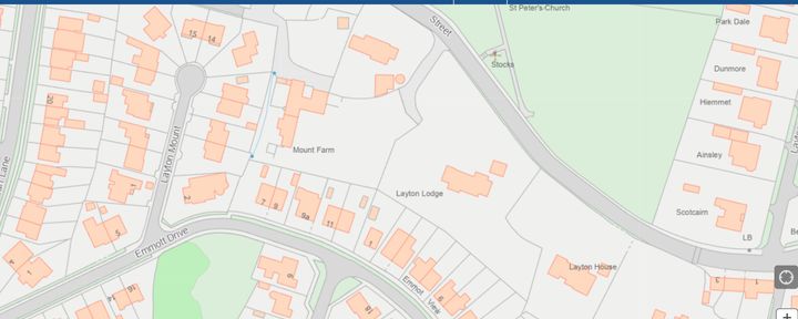
The quality of the image is degraded by the PH system, much clearer if you're using it. You can see a watercourse by the side of Mount Farm if that's any help. Unfortunately it doesn't show history. Looked at a place I was brought up and the house is still there but the name gone, just a number.
The website is https://highwaysreporting.suffolk.gov.uk/?type=5&a... the address search doesn't work outside Suffolk, but you can pan around the country, zoom in and out. Around that bit of Rawdon there are quite a number of houses with names in big plots. Guess if you can't recognise it maybe it's been knocked down and the plot used for multiple properties.
Further thought, any use looking up Births, Marriages, Death records for known family members, in case a number was written on the certificate?
Not much help, sorry, sounds an interesting exercise, going back to places lived and maybe holidayed.
Hi Paul (and other detectives!)
I was bored over Christmas and had a bit of a look into this (I found Violet as well).
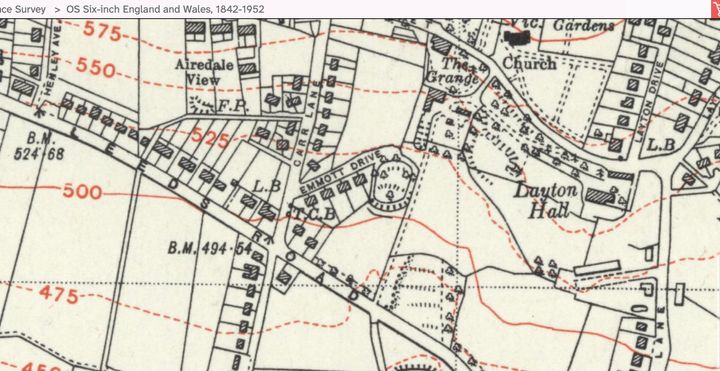
I don't know if it's of any help, but it appears that Emmott Drive was only the short bit at the top (west end?) until around the early 50's(?).
Silco's Historic England shows the 4 semi-detached houses on the south side of the original part of the road.
After this, Emmott Drive was extended all the way down to Layton Lane.
Could it be that 'Alderley' was therefore one of the houses in the original part of Emmott Drive?
Maps for reference...
A couple of things to note:
I have noticed spelling mistakes for 'Alderley' and 'Emmott' - It may just be the dreaded auto correct but potentially could confuse things when searching.
I live nowhere near this area and am not an expert in this field!
Good luck with your search Paul and Happy New Year to all.
I was bored over Christmas and had a bit of a look into this (I found Violet as well).
I don't know if it's of any help, but it appears that Emmott Drive was only the short bit at the top (west end?) until around the early 50's(?).
Silco's Historic England shows the 4 semi-detached houses on the south side of the original part of the road.
After this, Emmott Drive was extended all the way down to Layton Lane.
Could it be that 'Alderley' was therefore one of the houses in the original part of Emmott Drive?
Maps for reference...
A couple of things to note:
I have noticed spelling mistakes for 'Alderley' and 'Emmott' - It may just be the dreaded auto correct but potentially could confuse things when searching.
I live nowhere near this area and am not an expert in this field!
Good luck with your search Paul and Happy New Year to all.
Thanks to everyone who is searching on my behalf! Yes I just woke up after a great NYE party! I was at a private house with these guys and their musician friends till 3 am. https://www.facebook.com/profile.php?id=1000648988...
It was like a one night music festival!
Anyhow as I said the postie said he didn't know the house so I don't know if is the one. It was about 60 years ago...so my memory is somewhat faded....and my hair too. I'm hoping that the local history society can help after the holiday. If I am successful then I'll post it here first.
Gassing Station | The Lounge | Top of Page | What's New | My Stuff