The official winter 2013/2014 snow thread
Discussion


funkyrobot said:
Puggit said:
wiliferus said:
Same here  I'm hoping the death storm picks me up and spits me out in the Maldives
Mrs Puggit cooked a Maldivian curry tonight - I'm half way there! (Recipe scans available on request) I'm hoping the death storm picks me up and spits me out in the Maldives 
Wills2 said:
Has the storm formed then? From I got from last nights weather it hadn't and was still in the minds of the super computers.
Just wondering if it has started its track across the atlantic.
Christian has formed and Lorenzo is heading for their intimate liaison - all is on track as predicted by the computers Just wondering if it has started its track across the atlantic.
Fox- said:
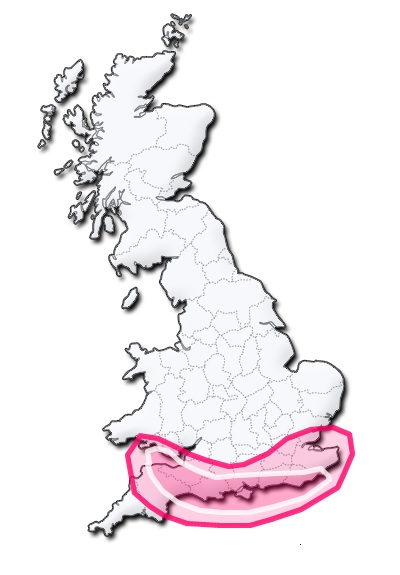
Every source has a completely different map, exactly who are we supposed to trust?
Still, this one shows Cornwall and half of Devon escaping, so that'll do nicely.
It's all down to fine tuning now - this latest met monkey map is their area of greatest concern - so it's still really anyone south of Plymouth-Wash who is in the line of fire and coastal areas to bear the brunt. Still, this one shows Cornwall and half of Devon escaping, so that'll do nicely.
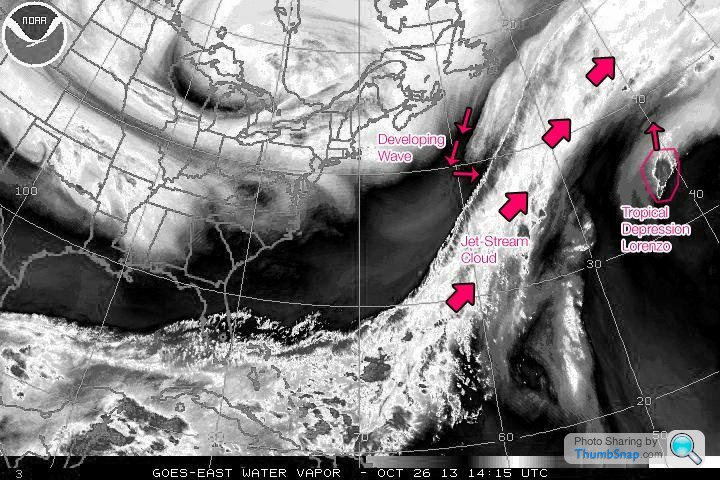
The storm has only recently formed, somewhere off the coast of Canada - it's pretty amazing how well this has been predicted by the computers.


OzzyR1 said:
Is this massive storm actually going to happen or is it the usual load of b ks from the media when there is a chance it might be a bit windy. Because its Autumn.
Puggit, you seem to be knowledgeable about this weather stuff, you think it'll really be as bad as the 87 storm?
The storm only came in to life yesterday, off the coast of Canada, so it's all been down to computers so far. That said, there is now a small climb down from the MetOffice:ks from the media when there is a chance it might be a bit windy. Because its Autumn.Puggit, you seem to be knowledgeable about this weather stuff, you think it'll really be as bad as the 87 storm?
"@fergieweather: W COUNTRY #ukstorm UPDATE 0730GMT: Increased hope of a less developed system tomorrow AM; uncertainty; but full update around 10-11am today."
"@fergieweather: W COUNTRY #ukstorm The current @metoffice assessment suggests 60-70% chance of a developed storm; 30-40% chance one much less so. More later"
This will be because there is now a visible storm that can be anticipated by experienced humans instead of programmed computers. No one has said it will be as bad as '87 (120mph winds) - the maximum forecast for this one has been 90mph winds. I think it's important to understand this will not be your average autumnal storm for the south, so precautions like tidying up your garden are a good idea.
Met-Monkey said:
Storm Update: The Evening model forecasts are beginning to slow down the intensification of The Monday storm, and as a result the tracking is further South. This would mean a few things; Less intense and damaging winds, the strongest winds would be confined to the South Coast and perhaps for inland Southern England, and the risk of seriously damaging winds would be reduced considerably. This is the latest trend, however we're not going to get complacent, this is a complex evolution and we urge you to not take this latest information as gospel. In light of the latest model complications and the possible downgrade in storm tracking and intensity, analysis of 06Z and 12Z data across all models is crucial. Be prepared for the worst, and be safe is the best advice.

Gassing Station | The Lounge | Top of Page | What's New | My Stuff