Critique my Wales weekend
Discussion


Claude455 said:
This weekend I'll be joined by a handful of other Clio 182 Trophy drivers - Snowdonia & north Wales on Saturday, Brecons & south Wales on Sunday - is anyone else going to be around?
I passed the convoy near Betws-y-Coed Shell (coming out of the A470?), I was in the Focus RS travelling in the opposite direction!I previously owned #168/T6PHY - a good little car that I took on a fair few adventures.
My route was roughly:
SAT: Llangollen > evo triangle laps > Beddgelert > Bala > Aberystwyth
SUN: Aberystwyth > Tregaron > Llandgadog > A4069 laps > A4059 laps
with a: 135M, TT-S, Fiesta-ST & Scirocco GT
I was in Llandudno yesterday and decided to try some more interesting roads on the way home.
A470 out of Conwy to Llanwrst
B5427 to Nebo
B5113 to Pentrefoelas
Few miles on A5 then right on to B4501 to Fran-goch
Left on to A4212 to Bala
B4391 to Penybontfawr, then B4396 to Knockin and A5 just south of Oswestry.
Superb roads that had only light traffic, more spectular, more challenging and quieter than the EVO triangle
I thought I'd bump this thread as its title is exactly what I'm looking for - comments, criticism, suggestions, recommendations and advice are all welcomed and encouraged 
Day 1 - Llangollen to Aberystwyth
https://goo.gl/maps/KRyMNgQrhyA2
Day 2 - Aber to Chepstow
https://goo.gl/maps/vW9TPQMTbTT2
Are there any decent toilet stops on the section between Abergavenny and Chepstow? We're a group of 10+ cars so ideally a public toilet with car park or similar...
Thanks in advance
Claude455 said:
I thought I'd bump this thread as its title is exactly what I'm looking for - comments, criticism, suggestions, recommendations and advice are all welcomed and encouraged
Day 1 - Llangollen to Aberystwyth
https://goo.gl/maps/KRyMNgQrhyA2
It's a shame you're going from Penygoes to Dylife because the scenery going the other way is far superior.Day 1 - Llangollen to Aberystwyth
https://goo.gl/maps/KRyMNgQrhyA2
If you have time, park up by the gate on the left and cross the road to the viewing platform here.
It is actually a memorial to Wynford Vaughan-Thomas. The vista on a clear day is stunning.
Claude455 said:
Day 2 - Aber to Chepstow
https://goo.gl/maps/vW9TPQMTbTT2
AFAIK you can only park up by Nantgwyllt Church - https://goo.gl/maps/M7zzy2ASEa32https://goo.gl/maps/vW9TPQMTbTT2
Even if you could drive up that adjoining track I'm not what you would gain from doing so.
This should be where you should be aiming for: Claerwen Dam.
https://goo.gl/maps/EMHE6Srs4Ds
n.b. the Google Maps trace takes you to the car park below the dam.
You need to fork right here to reach the location of the link above.
Claude455 said:
Are there any decent toilet stops on the section between Abergavenny and Chepstow? We're a group of 10+ cars so ideally a public toilet with car park or similar...
Should be some here - https://goo.gl/maps/D6WkSyeY4Gk - callContact info - https://www.spar.co.uk/store-locator/afb18703-spar...
HTH. Have fun.

Wow, is it a year since my trip?
From my experience I'd drop the Llanberis Pass and the rest of the lap around Snowdon on day 1 and go straight to Beddgelert. It's a beautiful location but if you're not there at dawn it's just too slow and busy to be a good drive, with no chance of an overtake.
This place was great for a late breakfast: http://www.cafesnowdon.co.uk/
The route around Lake Vyrnwy was very slow too and full of families walking and cycling. However the run there from Bala made it worthwhile, as did the views on the route out.
On day 2 the run from Aber to Elan is just great!
Red Devil said:
It's a shame you're going from Penygoes to Dylife because the scenery going the other way is far superior.
If you have time, park up by the gate on the left and cross the road to the viewing platform here.
It is actually a memorial to Wynford Vaughan-Thomas. The vista on a clear day is stunning.
That's not the first time I've read that. I'm reviewing a host of other roads and routes for a future trip and will definitely consider a direction reverse of this stretch. As for the stopping point, time will definitely be made if the conditions are favourable, thank you!If you have time, park up by the gate on the left and cross the road to the viewing platform here.
It is actually a memorial to Wynford Vaughan-Thomas. The vista on a clear day is stunning.
Red Devil said:
AFAIK you can only park up by Nantgwyllt Church - https://goo.gl/maps/M7zzy2ASEa32
Even if you could drive up that adjoining track I'm not what you would gain from doing so.
This should be where you should be aiming for: Claerwen Dam.
https://goo.gl/maps/EMHE6Srs4Ds
n.b. the Google Maps trace takes you to the car park below the dam.
You need to fork right here to reach the location of the link above.
Sorted - this was a technical error, I've got no intention of driving an inappropriate route especially after a near disaster in a previous year. We will definitely visit top and bottom car parks at Claerwen (if time allows).Even if you could drive up that adjoining track I'm not what you would gain from doing so.
This should be where you should be aiming for: Claerwen Dam.
https://goo.gl/maps/EMHE6Srs4Ds
n.b. the Google Maps trace takes you to the car park below the dam.
You need to fork right here to reach the location of the link above.
Red Devil said:
Should be some here - https://goo.gl/maps/D6WkSyeY4Gk - call
Contact info - https://www.spar.co.uk/store-locator/afb18703-spar...
That is absolutely perfect, thank you so much for this, and all of your feedback.Contact info - https://www.spar.co.uk/store-locator/afb18703-spar...
giveitfish said:
Wow, is it a year since my trip?
From my experience I'd drop the Llanberis Pass and the rest of the lap around Snowdon on day 1 and go straight to Beddgelert. It's a beautiful location but if you're not there at dawn it's just too slow and busy to be a good drive, with no chance of an overtake.
This place was great for a late breakfast: http://www.cafesnowdon.co.uk/
The route around Lake Vyrnwy was very slow too and full of families walking and cycling. However the run there from Bala made it worthwhile, as did the views on the route out.
On day 2 the run from Aber to Elan is just great!
Llaberis Pass is great for the views but I agree, I've never had a decent run, it's included more for the spectacular scenery than the ability to stretch legs.From my experience I'd drop the Llanberis Pass and the rest of the lap around Snowdon on day 1 and go straight to Beddgelert. It's a beautiful location but if you're not there at dawn it's just too slow and busy to be a good drive, with no chance of an overtake.
This place was great for a late breakfast: http://www.cafesnowdon.co.uk/
The route around Lake Vyrnwy was very slow too and full of families walking and cycling. However the run there from Bala made it worthwhile, as did the views on the route out.
On day 2 the run from Aber to Elan is just great!
Thanks for posting (/going) all those months ago and providing others like me with even more inspiration

Claude455 said:
As for the stopping point, time will definitely be made if the conditions are favourable, thank you!
D'oh! I didn't factor in the number of cars in your group. 
It is very likely that the gate will be locked. If so, it will be a challenge getting that many off the blacktop.
You'll just have to hope nobody else wants to do likewise on the day.
Using both sides and some ingenuity, you should be able to get 6, possibly 7, parked up.
The rest will have to take their chances further up the hill at the lay-by here.
Red Devil said:
D'oh! I didn't factor in the number of cars in your group.
It is very likely that the gate will be locked. If so, it will be a challenge getting that many off the blacktop.
You'll just have to hope nobody else wants to do likewise on the day.
Using both sides and some ingenuity, you should be able to get 6, possibly 7, parked up.
The rest will have to take their chances further up the hill at the lay-by here.
It's been done before It is very likely that the gate will be locked. If so, it will be a challenge getting that many off the blacktop.
You'll just have to hope nobody else wants to do likewise on the day.
Using both sides and some ingenuity, you should be able to get 6, possibly 7, parked up.
The rest will have to take their chances further up the hill at the lay-by here.
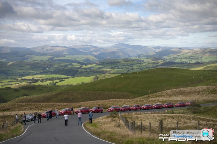
Hmmm. 8 of those cars are on the main carriageway effectively making it a single track road.
A tad unfair on those who are making progress in opposite directions if they were to encounter each other at that point, no?
Just had a look at the rest of the pics. Epic. Looks like you'll be doing a reprise of a fair bit of last year's route.
If you haven't done it before, add the Tregaron to Abergwesyn mountain road* to your list.
It's not made for swift progress; it's all about the scenery and the technical ability of both car and driver - http://www.dangerousroads.org/europe/wales/3989-ab...
The side trip is to the dam at Lynne Brianne. The surface is better on this section as it was built when the reservoir was created.
At one time the mountain road had possibly the most remote functioning public phone box in Wales, possibly the entire UK.
http://www.geograph.org.uk/photo/905572
https://goo.gl/maps/9w1fsGdmuKS2
*The first time I did it was way back when competetive rallies were permitted on public roads.
Driving flat out in the dark at 2am in one of these can be, er, 'interesting'.
Especially when neither you nor your navigator have any local knowledge.
Pace notes were not allowed and the best you could do is use 1" OS 'marked maps'.
I caught up with another car whose driver let me past here - https://goo.gl/maps/QZ6cA8gN4r22
The upshot was I got a bit off line and almost had an Ari Vatanen (2:00) moment at the cattle grid.
If I had gone agricultural it would have been a 1.5 mile walk back to that phonebox.
Leaping out of the way every time another rally car appeared...
Red Devil said:
Hmmm. 8 of those cars are on the main carriageway effectively making it a single track road.
A tad unfair on those who are making progress in opposite directions if they were to encounter each other at that point, no?
Just had a look at the rest of the pics. Epic. Looks like you'll be doing a reprise of a fair bit of last year's route.
If you haven't done it before, add the Tregaron to Abergwesyn mountain road* to your list.
It's not made for swift progress; it's all about the scenery and the technical ability of both car and driver - http://www.dangerousroads.org/europe/wales/3989-ab...
The side trip is to the dam at Lynne Brianne. The surface is better on this section as it was built when the reservoir was created.
At one time the mountain road had possibly the most remote functioning public phone box in Wales, possibly the entire UK.
http://www.geograph.org.uk/photo/905572
https://goo.gl/maps/9w1fsGdmuKS2
*The first time I did it was way back when competetive rallies were permitted on public roads.
Driving flat out in the dark at 2am in one of these can be, er, 'interesting'.
Especially when neither you nor your navigator have any local knowledge.
Pace notes were not allowed and the best you could do is use 1" OS 'marked maps'.
I caught up with another car whose driver let me past here - https://goo.gl/maps/QZ6cA8gN4r22
The upshot was I got a bit off line and almost had an Ari Vatanen (2:00) moment at the cattle grid.
If I had gone agricultural it would have been a 1.5 mile walk back to that phonebox.
Leaping out of the way every time another rally car appeared...
Impossible to defend the indefensible in terms of parking on the carriageway, so I won't try.A tad unfair on those who are making progress in opposite directions if they were to encounter each other at that point, no?
Just had a look at the rest of the pics. Epic. Looks like you'll be doing a reprise of a fair bit of last year's route.
If you haven't done it before, add the Tregaron to Abergwesyn mountain road* to your list.
It's not made for swift progress; it's all about the scenery and the technical ability of both car and driver - http://www.dangerousroads.org/europe/wales/3989-ab...
The side trip is to the dam at Lynne Brianne. The surface is better on this section as it was built when the reservoir was created.
At one time the mountain road had possibly the most remote functioning public phone box in Wales, possibly the entire UK.
http://www.geograph.org.uk/photo/905572
https://goo.gl/maps/9w1fsGdmuKS2
*The first time I did it was way back when competetive rallies were permitted on public roads.
Driving flat out in the dark at 2am in one of these can be, er, 'interesting'.
Especially when neither you nor your navigator have any local knowledge.
Pace notes were not allowed and the best you could do is use 1" OS 'marked maps'.
I caught up with another car whose driver let me past here - https://goo.gl/maps/QZ6cA8gN4r22
The upshot was I got a bit off line and almost had an Ari Vatanen (2:00) moment at the cattle grid.
If I had gone agricultural it would have been a 1.5 mile walk back to that phonebox.
Leaping out of the way every time another rally car appeared...
The Tregaron to Abergwesyn mountain road is on my list of roads to recce before unleashing it on the group, as is the detour to Lynne Brianne. Sadly I've not had enough time to do the exploration beforehand so much of this year's route is similar to last, but any additional info is being captured and stored ready for the next free weekend I get, whenever that might be.
Interesting info about the phone box, and that must have been an interesting cattle grid 'moment', my hands are a little clammy just thinking about it!
Red Devil said:
At one time the mountain road had possibly the most remote functioning public phone box in Wales, possibly the entire UK.
http://www.geograph.org.uk/photo/905572
https://goo.gl/maps/9w1fsGdmuKS2
*The first time I did it was way back when competetive rallies were permitted on public roads.
Driving flat out in the dark at 2am in one of these can be, er, 'interesting'.
Especially when neither you nor your navigator have any local knowledge.
Pace notes were not allowed and the best you could do is use 1" OS 'marked maps'.
I caught up with another car whose driver let me past here - https://goo.gl/maps/QZ6cA8gN4r22
The upshot was I got a bit off line and almost had an Ari Vatanen (2:00) moment at the cattle grid.
If I had gone agricultural it would have been a 1.5 mile walk back to that phonebox.
Leaping out of the way every time another rally car appeared...
Even scrotes get to the most remote places and the phone box is just a box after the attentions of vandals. No glass and no phone after BT pulled the plug a while back. Mobile signal is pretty much non-existent so these days it'll be a long walk for help unless it's a 999 and you do manage to pick up a signal. http://www.geograph.org.uk/photo/905572
https://goo.gl/maps/9w1fsGdmuKS2
*The first time I did it was way back when competetive rallies were permitted on public roads.
Driving flat out in the dark at 2am in one of these can be, er, 'interesting'.
Especially when neither you nor your navigator have any local knowledge.
Pace notes were not allowed and the best you could do is use 1" OS 'marked maps'.
I caught up with another car whose driver let me past here - https://goo.gl/maps/QZ6cA8gN4r22
The upshot was I got a bit off line and almost had an Ari Vatanen (2:00) moment at the cattle grid.
If I had gone agricultural it would have been a 1.5 mile walk back to that phonebox.
Leaping out of the way every time another rally car appeared...

Gassing Station | Roads | Top of Page | What's New | My Stuff