Best map for Western Isles?
Discussion


I'm off to Loch Long on holiday in a few months, and was just looking at my atlas to work out a draft itinerary. Trouble is that it's not very good for the islands, managing to fit all western and northern on one page. Anyone got a recommendation of a road atlas that covers the highlands and islands well?
Also, i assume CalMac are the only ferry operators? Routes are great, but my plan to do Across Skye then ferry yo South Uist drive up to Stornoway and ferry back in one day doesn't really fit with their ratehr relaxed timetables.
Also, i assume CalMac are the only ferry operators? Routes are great, but my plan to do Across Skye then ferry yo South Uist drive up to Stornoway and ferry back in one day doesn't really fit with their ratehr relaxed timetables.
agent006 said:
my plan to do Across Skye then ferry yo South Uist drive up to Stornoway and ferry back in one day doesn't really fit with their ratehr relaxed timetables.
That's a bloody long drive for one day ... and almost impossible with the ferries (just looked)
May I suggest you stay here (I love this place) for the night and take a relaxed walk on the nearby white sand the next day?
www.rodelhotel.co.uk/ (check out the food page!)
... and to give you a flavour of what you'll miss if you are in the car all day: www.stevecarter.com/harris2004/harris2004.htm
(mind you, if it's raining, I'd stay in the car and get away asap!
 )
) Steve
Edited by GetCarter on Saturday 29th July 18:19
agent006 said:
my plan to do Across Skye then ferry yo South Uist drive up to Stornoway and ferry back in one day doesn't really fit with their ratehr relaxed timetables.
All the best for your trip, and I hope that this fantastic summer lasts for your visit. However I think you have much to learn, grasshopper, about the ways of the west and CalMac, not to mention S Uist & Stornoway. The distances involved, mountains, roads, scenery, and time to cross west coast stretches of water are all conspiring against your haste. The frequency of the ferries is in proportion to the population.
Quotation from a friend from Skye: "Man~ana: we don't have a word which expresses quite that amount of urgency".

As a bit of homework for the trip, buy "Local Hero" and watch at least 3 times.
J
Edited by John_W on Saturday 29th July 21:11
I can sort of see Loch Long from my window, however to do Stornoway and back in one day...pah no chance!.
It will take you about 4 hours to get to Uig on Skye for the Ferry anyway so I would count this out, try checking into a guest house for the night, and don't arrange yout trip over a sunday...you will be stuck there FOREVER!!!!.
Just joking nothing happens/works/moves on a sunday on the Western isles!.
If you go Skye, Uist, Harris, Lewis, It's 3 ferries and about 180 miles drive (on very twisty, slow roads)... but it's the three ferries that will screw you.
You could miss out Uist and do early start at (Uig) on Skye, to Tarbet (on Harris) drive round the whole of Harris then round Lewis (taking in the west coast), and from Stornaway (on Lewis)to Ullapool (mainland) in one day. That's about 120 miles and do-able with only two ferries (I haven't checked the timetable, but I did this myself about 6 years ago).
IMHO South Harris/West Lewis are prittier than Uist (I know some will disagree!)
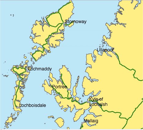
FYI - here is a map showing the length of the islands to scale - tip to tip think London to Bristol (but on B roads)
Steve
You could miss out Uist and do early start at (Uig) on Skye, to Tarbet (on Harris) drive round the whole of Harris then round Lewis (taking in the west coast), and from Stornaway (on Lewis)to Ullapool (mainland) in one day. That's about 120 miles and do-able with only two ferries (I haven't checked the timetable, but I did this myself about 6 years ago).
IMHO South Harris/West Lewis are prittier than Uist (I know some will disagree!)
FYI - here is a map showing the length of the islands to scale - tip to tip think London to Bristol (but on B roads)
Steve
Edited by GetCarter on Sunday 30th July 09:50
Don't forget - someone talked about "manyana" in Spain - in the Hebrides ( outer or inner ) -Tomorrow - never comes - and with the old Highland roads (from my only trip to Skye) 25MPH would be speeding - your average Highlander don't want to move that fast- never will( unless there's a "a good dram " in it for him) -- sorry , but i'm an exiled highlander(from the mainland, spent years at school with islanders) - so i know how they behave and act , and in the islands , folk move even slower .
oldie said:
your average Highlander don't want to move that fast- never will
Unless that Highlander has the inclination for WOT on the epic flat out Kyleakin to Broadford road,the off camber long right hander at Fairy Bridge, or even the hairpins and long but bumpy straight
 near Struan on the Sligachan to Dunvegan route!
 I'm from Skye btw

HAB said:
oldie said:
your average Highlander don't want to move that fast- never will
I'm from Skye btw
No reflection on anyone in particular - just a reflection on the old adage "when god made time ,he made plenty of it " -(I'm from kust accross the water ,origonally)
Apart from that - trying to get the idea accross ( as others knowing the area ) that to get round in the time they think they can --in autumn - they won't see anything, probably not even the deer that they hit.
In summer - the tourists are out, in winter - does ice still form on the rocks on the seashore ?
Get yourself down to an Ordnance Survey map stockist and ask for a free 2001 Mapping Index (see this web page www.ordnancesurvey.co.uk/oswebsite/media/news/2001/jan/mapindex.html ). That will show you all the maps available.
If you just want to scope out a route, then the 1:250,000 (1 inch to 4 miles which is the same as the RAC atlas) Road Map 2 covering Western Scotland & the Western Isles should do you at a cost of £4.99. If you can't be bothered to go to a map shop, you can order online here: www.ordnancesurvey.co.uk/oswebsite/mapshop/ .
If you need more detail, then Landranger maps at 1:50,000 scale (2cm=1Km) will give you as much detail as you could wish for (unless you are walking) at £6.49 each which is good value. There is too much detail on these maps for a quick trip, so I think you probably need the 1:250,000.
Alternatively get an AA or RAC atlas, however they give you the spatial relationship problems which you mentioned initially.
J
Edited by John_W on Monday 14th August 20:53
Edited by John_W on Monday 14th August 20:54
You could try multimap.com to get maps of the scale you want - print them off in A4.SABRE (www.sabre.org.uk) has bescriptions of each road by number, and from their site they probably could help. Don't know if the fuel companies still do maps of areas(like Highlands and Islands) -they used to and they were cheap.
Try entering "Highlands and Islands Tourist Board " in a search engine - they want tourists and probably can help, or put you in touch with the right area.
Try entering "Highlands and Islands Tourist Board " in a search engine - they want tourists and probably can help, or put you in touch with the right area.

Gassing Station | Scotland | Top of Page | What's New | My Stuff