What’s the speed limit on this road?
Discussion


Wardy5 said:
Where this one gets a bit grey for me is that it's missing actual 'dual carriageway' signage. The importance of that is that's a legal requirement for the dual carriageway to exist. The only reason I can think of for this to be missing, is that it's so obvious! Given you can't even see the northbound carriageway at the point of entry onto the southbound section.
But there's also the fitting of continuing 'one way' signs along the section. Which leads me to think that they may have designed it, in effect, as a one-way section with two lanes. Which would therefore NOT be under national 70mph designation, but 60mph:
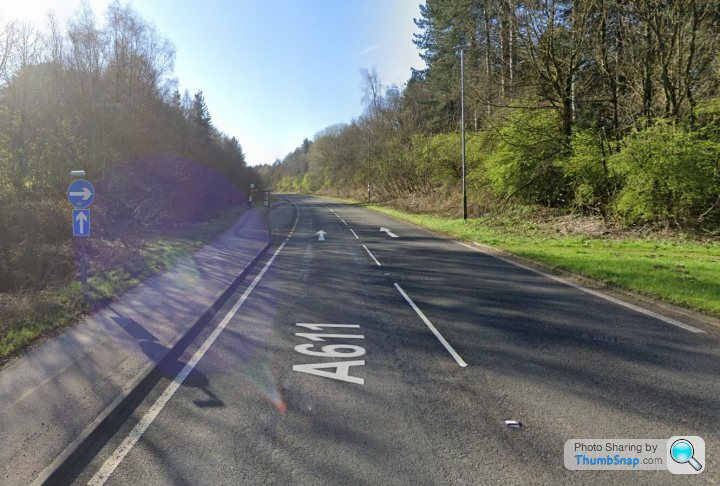
Suffice to say, if you need to go to these lengths to understand what's going on, they've not designed it very well. And they'd do well to just put some actual speed signage along the southbound stretch instead!
I know nothing about this road being discussed, but if you placed me in the picture telling me it was subject to NSL and asked me what the speed limit was, I would have to say it is 60mph for the reasons you state.But there's also the fitting of continuing 'one way' signs along the section. Which leads me to think that they may have designed it, in effect, as a one-way section with two lanes. Which would therefore NOT be under national 70mph designation, but 60mph:
Suffice to say, if you need to go to these lengths to understand what's going on, they've not designed it very well. And they'd do well to just put some actual speed signage along the southbound stretch instead!
I cannot see another carriageway so to me it is simply a one way road.
As you rightly say it would benefit from some signage.
Here's another example of a central wooded area with no barrier dividing a d/c. The A24 in West Sussex.
50 Southbound - https://maps.app.goo.gl/sTmNoTevMYhh23sq7
70 Northbound - https://maps.app.goo.gl/vuV96xTCkRGKSvhE9
50 Southbound - https://maps.app.goo.gl/sTmNoTevMYhh23sq7
70 Northbound - https://maps.app.goo.gl/vuV96xTCkRGKSvhE9
Red Devil said:
Here's another example of a central wooded area with no barrier dividing a d/c. The A24 in West Sussex.
50 Southbound - https://maps.app.goo.gl/sTmNoTevMYhh23sq7
70 Northbound - https://maps.app.goo.gl/vuV96xTCkRGKSvhE9
The A33 here meets that bill:50 Southbound - https://maps.app.goo.gl/sTmNoTevMYhh23sq7
70 Northbound - https://maps.app.goo.gl/vuV96xTCkRGKSvhE9


Red Devil said:
Here's another example of a central wooded area with no barrier dividing a d/c. The A24 in West Sussex.
50 Southbound - https://maps.app.goo.gl/sTmNoTevMYhh23sq7
70 Northbound - https://maps.app.goo.gl/vuV96xTCkRGKSvhE9
Not truly correct, the speed limits vary and change in both directions, presumably to accommodate the various entries/exits on each side.50 Southbound - https://maps.app.goo.gl/sTmNoTevMYhh23sq7
70 Northbound - https://maps.app.goo.gl/vuV96xTCkRGKSvhE9
What about this one folks ? Roundabout on top of the M5. There is a NSL sign at the top of Ettlingen Way (which is 40mph). I think it is 70mph . I am poor at links i trust it works.
https://maps.app.goo.gl/a2eFvovfgDYME5vQA
https://maps.app.goo.gl/a2eFvovfgDYME5vQA
markymarkthree said:
What about this one folks ? Roundabout on top of the M5. There is a NSL sign at the top of Ettlingen Way (which is 40mph). I think it is 70mph . I am poor at links i trust it works.
https://maps.app.goo.gl/a2eFvovfgDYME5vQA
The street lamps indicate it would be 30. That is further indicated by;https://maps.app.goo.gl/a2eFvovfgDYME5vQA
No repeaters on the lamp posts, and also but the fact that speed limits are shown on all exit roads (depending on which view you have, one road is shown as 60 in one view and 50 in another, the danger of digital map views!).
One slip-road onto motorway shows no speed limit sign, in the other direction the slip road shows a NSL sign. Technically, AFAIK, if you have a motorway sign, there is no need for a NSL sign, the M.Way sign takes the place of that (as you leave Liverpool to head east onto the M62, you go from a 40 limit to a M.Way, so that becomes 70, for cars).
Pica-Pica said:
markymarkthree said:
What about this one folks ? Roundabout on top of the M5. There is a NSL sign at the top of Ettlingen Way (which is 40mph). I think it is 70mph . I am poor at links i trust it works.
https://maps.app.goo.gl/a2eFvovfgDYME5vQA
The street lamps indicate it would be 30. That is further indicated by;https://maps.app.goo.gl/a2eFvovfgDYME5vQA
No repeaters on the lamp posts, and also but the fact that speed limits are shown on all exit roads (depending on which view you have, one road is shown as 60 in one view and 50 in another, the danger of digital map views!).
One slip-road onto motorway shows no speed limit sign, in the other direction the slip road shows a NSL sign. Technically, AFAIK, if you have a motorway sign, there is no need for a NSL sign, the M.Way sign takes the place of that (as you leave Liverpool to head east onto the M62, you go from a 40 limit to a M.Way, so that becomes 70, for cars).
I think you are looking at the wrong roundabout, as there are no street lamps on the roundabout on top of the M5. Ettlingen way is 40mph, where it joins the roundabout on top of the M5 there is a NSL sign. It is the limit of that roundabout i am interested in.
markymarkthree said:
Pica-Pica said:
markymarkthree said:
What about this one folks ? Roundabout on top of the M5. There is a NSL sign at the top of Ettlingen Way (which is 40mph). I think it is 70mph . I am poor at links i trust it works.
https://maps.app.goo.gl/a2eFvovfgDYME5vQA
The street lamps indicate it would be 30. That is further indicated by;https://maps.app.goo.gl/a2eFvovfgDYME5vQA
No repeaters on the lamp posts, and also but the fact that speed limits are shown on all exit roads (depending on which view you have, one road is shown as 60 in one view and 50 in another, the danger of digital map views!).
One slip-road onto motorway shows no speed limit sign, in the other direction the slip road shows a NSL sign. Technically, AFAIK, if you have a motorway sign, there is no need for a NSL sign, the M.Way sign takes the place of that (as you leave Liverpool to head east onto the M62, you go from a 40 limit to a M.Way, so that becomes 70, for cars).
I think you are looking at the wrong roundabout, as there are no street lamps on the roundabout on top of the M5. Ettlingen way is 40mph, where it joins the roundabout on top of the M5 there is a NSL sign. It is the limit of that roundabout i am interested in.
Pica-Pica said:
Red Devil said:
Here's another example of a central wooded area with no barrier dividing a d/c. The A24 in West Sussex.
50 Southbound - https://maps.app.goo.gl/sTmNoTevMYhh23sq7
70 Northbound - https://maps.app.goo.gl/vuV96xTCkRGKSvhE9
Not truly correct, the speed limits vary and change in both directions, presumably to accommodate the various entries/exits on each side.50 Southbound - https://maps.app.goo.gl/sTmNoTevMYhh23sq7
70 Northbound - https://maps.app.goo.gl/vuV96xTCkRGKSvhE9
It's 60 from the Southwater roundabout until it drops to 50 (as above), where it remains after emerging from the wooded section to the A272 crossroads at Buck Barn and beyond.
It was originally NSL but the reductions were introduced for safety reasons. The bends and junction at The Bar were particularly high risk.
The northbound 70 remains unchanged past the roundabout until it drops to 60 at Broadbridge Heath.
The southbound carriageway is the original A24. When it was upgraded to a d/c, the northbound carriageway followed a different alignment.
Hence the wide separation at The Bar which is directly comparable to the A611.
I am happy to be schooled, but my experience of Dual Carriageways is that they should be signed as such where a road splits.
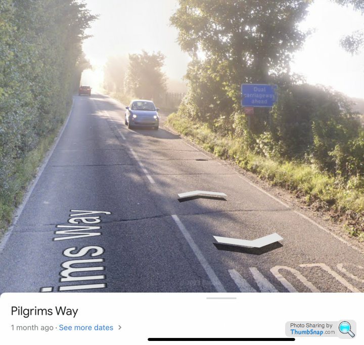
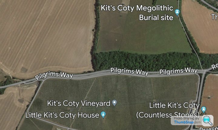
Below is the Pilgrims way in Kent, travelling left to right. It’s now. 40mph limit, but used to be NSL years ago.
https://maps.app.goo.gl/7XFLqQ3MDfw7U2Fy8?g_st=ic
 |https://thumbsnap.com/H9Xtag3m[/url]
The lack of signage at the opposite end, could just be a decades old mistake though.
https://maps.app.goo.gl/Ei2Z4n2ahXHBp3sH9?g_st=ic
 [url]
[url]
Below is the Pilgrims way in Kent, travelling left to right. It’s now. 40mph limit, but used to be NSL years ago.
https://maps.app.goo.gl/7XFLqQ3MDfw7U2Fy8?g_st=ic
|https://thumbsnap.com/H9Xtag3m[/url]The lack of signage at the opposite end, could just be a decades old mistake though.
https://maps.app.goo.gl/Ei2Z4n2ahXHBp3sH9?g_st=ic
[url]Edited by Hol on Monday 23 October 16:29
Hol said:
I am happy to be schooled, but my experience of Dual Carriageways is that they should be signed as such where a road splits.
Below is the Pilgrims way in Kent, travelling left to right. It’s now. 40mph limit, but used to be NSL years ago.
https://maps.app.goo.gl/7XFLqQ3MDfw7U2Fy8?g_st=ic
|https://thumbsnap.com/H9Xtag3m[/url]
The lack of signage at the opposite end, could just be a decades old mistake though.
https://maps.app.goo.gl/Ei2Z4n2ahXHBp3sH9?g_st=ic
[url]
Especially famous for …. being on pistonheads whenever dual carriageways are mentioned.Below is the Pilgrims way in Kent, travelling left to right. It’s now. 40mph limit, but used to be NSL years ago.
https://maps.app.goo.gl/7XFLqQ3MDfw7U2Fy8?g_st=ic
|https://thumbsnap.com/H9Xtag3m[/url]The lack of signage at the opposite end, could just be a decades old mistake though.
https://maps.app.goo.gl/Ei2Z4n2ahXHBp3sH9?g_st=ic
[url]Edited by Hol on Monday 23 October 16:29
Yes it used to be NSL.
Red Devil said:
Pica-Pica said:
Red Devil said:
Here's another example of a central wooded area with no barrier dividing a d/c. The A24 in West Sussex.
50 Southbound - https://maps.app.goo.gl/sTmNoTevMYhh23sq7
70 Northbound - https://maps.app.goo.gl/vuV96xTCkRGKSvhE9
Not truly correct, the speed limits vary and change in both directions, presumably to accommodate the various entries/exits on each side.50 Southbound - https://maps.app.goo.gl/sTmNoTevMYhh23sq7
70 Northbound - https://maps.app.goo.gl/vuV96xTCkRGKSvhE9
It's 60 from the Southwater roundabout until it drops to 50 (as above), where it remains after emerging from the wooded section to the A272 crossroads at Buck Barn and beyond.
It was originally NSL but the reductions were introduced for safety reasons. The bends and junction at The Bar were particularly high risk.
The northbound 70 remains unchanged past the roundabout until it drops to 60 at Broadbridge Heath.
The southbound carriageway is the original A24. When it was upgraded to a d/c, the northbound carriageway followed a different alignment.
Hence the wide separation at The Bar which is directly comparable to the A611.

Hol said:
I am happy to be schooled, but my experience of Dual Carriageways is that they should be signed as such where a road splits.
Below is the Pilgrims way in Kent, travelling left to right. It’s now. 40mph limit, but used to be NSL years ago.
https://maps.app.goo.gl/7XFLqQ3MDfw7U2Fy8?g_st=ic
|https://thumbsnap.com/H9Xtag3m[/url]
The lack of signage at the opposite end, could just be a decades old mistake though.
https://maps.app.goo.gl/Ei2Z4n2ahXHBp3sH9?g_st=ic
[url]
No such rule.Below is the Pilgrims way in Kent, travelling left to right. It’s now. 40mph limit, but used to be NSL years ago.
https://maps.app.goo.gl/7XFLqQ3MDfw7U2Fy8?g_st=ic
|https://thumbsnap.com/H9Xtag3m[/url]The lack of signage at the opposite end, could just be a decades old mistake though.
https://maps.app.goo.gl/Ei2Z4n2ahXHBp3sH9?g_st=ic
[url]Edited by Hol on Monday 23 October 16:29


Edited by Solocle on Monday 23 October 16:56
Gassing Station | Advanced Driving | Top of Page | What's New | My Stuff