Veloviewer. Who is using it, and what do you get from it?
Discussion


Yup. I'm confident the Edge 500 can upload direct to Strava. But I'd rather the whole ride was up there. I suppose the solution will be to upload the Edge 500's portion of the ride, then delete that activity if/when the ForeRunner 910XT provides the data through the server for the full ride.
I've just been looking at new Garmins on the Halfords (  ) website.
Edge 130 for £99
Edge 520 for £199
One has breadcrumb trail nav, the other a map-based full nav system. Plus other features I'll probably not use. Either seems to be good for 15 hours, and I'm not so much into following set routes anyway. I'll always be that rider with an OS map in his jersey pocket, I think. Both should be able to upload direct to Strava, bypassing this Garmin server issue. It's either that or first get a quote for repair of my edge 500 with new battery and rear case. I suppose the quote for that will see whether it's just better to 'bite the bullet' and buy a new GPS for the first time ever. I've got all the cadence sensors and HRMs already for Garmin (presuming backward compatibility) so paying extra for a bundle isn't necessary. But the one thing that's essential for VV tiling is a reliable GPS unit with decent battery life. It's about time I invested in some reliability instead of riding with my fingers crossed and getting frustrated with the ANT+ upload system of the ForeRunner 910XT.
) website.Edge 130 for £99
Edge 520 for £199
One has breadcrumb trail nav, the other a map-based full nav system. Plus other features I'll probably not use. Either seems to be good for 15 hours, and I'm not so much into following set routes anyway. I'll always be that rider with an OS map in his jersey pocket, I think. Both should be able to upload direct to Strava, bypassing this Garmin server issue. It's either that or first get a quote for repair of my edge 500 with new battery and rear case. I suppose the quote for that will see whether it's just better to 'bite the bullet' and buy a new GPS for the first time ever. I've got all the cadence sensors and HRMs already for Garmin (presuming backward compatibility) so paying extra for a bundle isn't necessary. But the one thing that's essential for VV tiling is a reliable GPS unit with decent battery life. It's about time I invested in some reliability instead of riding with my fingers crossed and getting frustrated with the ANT+ upload system of the ForeRunner 910XT.
yellowjack said:
I've just been looking at new Garmins on the Halfords ( ) website.
Edge 130 for £99
Edge 520 for £199
One has breadcrumb trail nav, the other a map-based full nav system. Plus other features I'll probably not use. Either seems to be good for 15 hours, and I'm not so much into following set routes anyway. I'll always be that rider with an OS map in his jersey pocket, I think. Both should be able to upload direct to Strava, bypassing this Garmin server issue. It's either that or first get a quote for repair of my edge 500 with new battery and rear case. I suppose the quote for that will see whether it's just better to 'bite the bullet' and buy a new GPS for the first time ever. I've got all the cadence sensors and HRMs already for Garmin (presuming backward compatibility) so paying extra for a bundle isn't necessary. But the one thing that's essential for VV tiling is a reliable GPS unit with decent battery life. It's about time I invested in some reliability instead of riding with my fingers crossed and getting frustrated with the ANT+ upload system of the ForeRunner 910XT.
Hmm, I'd go for a 530 if possible. There's the EveryTile app for the garmins... but I run a Wahoo Roam, and the quality of the maps was a useful feature when I found the bridleway I'd intended on following completely impassable.... I was able to get back to my route and make sure that I hit the requisite tiles. ) website.Edge 130 for £99
Edge 520 for £199
One has breadcrumb trail nav, the other a map-based full nav system. Plus other features I'll probably not use. Either seems to be good for 15 hours, and I'm not so much into following set routes anyway. I'll always be that rider with an OS map in his jersey pocket, I think. Both should be able to upload direct to Strava, bypassing this Garmin server issue. It's either that or first get a quote for repair of my edge 500 with new battery and rear case. I suppose the quote for that will see whether it's just better to 'bite the bullet' and buy a new GPS for the first time ever. I've got all the cadence sensors and HRMs already for Garmin (presuming backward compatibility) so paying extra for a bundle isn't necessary. But the one thing that's essential for VV tiling is a reliable GPS unit with decent battery life. It's about time I invested in some reliability instead of riding with my fingers crossed and getting frustrated with the ANT+ upload system of the ForeRunner 910XT.
OK then.
Decision made. Edge500 partial GPS trace uploaded. Details below...

Yesterday's hilly route through rural Dorset.
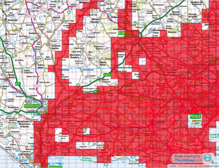
How it looked before this ride.

How it looks following the Edge 500 data upload.
There should be four or possibly five additional tiles to add if/when the data comes out of the 910XT watch, but the bulk (39) of the new tiles are all present and correct, with no need to fudge things with a reconstruction using digital trickery.
Decision made. Edge500 partial GPS trace uploaded. Details below...
Yesterday's hilly route through rural Dorset.
How it looked before this ride.
How it looks following the Edge 500 data upload.
There should be four or possibly five additional tiles to add if/when the data comes out of the 910XT watch, but the bulk (39) of the new tiles are all present and correct, with no need to fudge things with a reconstruction using digital trickery.
Solocle said:
Hmm, I'd go for a 530 if possible. There's the EveryTile app for the garmins... but I run a Wahoo Roam, and the quality of the maps was a useful feature when I found the bridleway I'd intended on following completely impassable.... I was able to get back to my route and make sure that I hit the requisite tiles.
£232.69 is more than I can afford to spend on a GPS though. And it seems to have a lot of features I probably wouldn't use. The Edge 130 seems to be about where I can stretch to right now, sadly. I mean, there's not a huge jump between the 520 and the 530 so the extra £32.69 would make sense. But the gulf in price between the 130 and any of the 500 series would make it a difficult bridge to cross.Edit:
Anyone know for sure that you can upload direct to Strava from the Edge 130? It doesn't tell me in the various product descriptions, and my laptop is overheating intermittently so reading through an entire DC rainmaker review is nigh on impossible!
Edited by yellowjack on Friday 24th July 14:50
yellowjack said:
I've just been looking at new Garmins on the Halfords ( ) website.
Edge 130 for £99
Edge 520 for £199
One has breadcrumb trail nav, the other a map-based full nav system. Plus other features I'll probably not use. Either seems to be good for 15 hours, and I'm not so much into following set routes anyway. I'll always be that rider with an OS map in his jersey pocket, I think. Both should be able to upload direct to Strava, bypassing this Garmin server issue. It's either that or first get a quote for repair of my edge 500 with new battery and rear case. I suppose the quote for that will see whether it's just better to 'bite the bullet' and buy a new GPS for the first time ever. I've got all the cadence sensors and HRMs already for Garmin (presuming backward compatibility) so paying extra for a bundle isn't necessary. But the one thing that's essential for VV tiling is a reliable GPS unit with decent battery life. It's about time I invested in some reliability instead of riding with my fingers crossed and getting frustrated with the ANT+ upload system of the ForeRunner 910XT.
Make sure you watch a video on how the navigation works on YouTube before you buy anything. Personally I couldn't use the 130 for navigating - it doesn't even have a map ) website.Edge 130 for £99
Edge 520 for £199
One has breadcrumb trail nav, the other a map-based full nav system. Plus other features I'll probably not use. Either seems to be good for 15 hours, and I'm not so much into following set routes anyway. I'll always be that rider with an OS map in his jersey pocket, I think. Both should be able to upload direct to Strava, bypassing this Garmin server issue. It's either that or first get a quote for repair of my edge 500 with new battery and rear case. I suppose the quote for that will see whether it's just better to 'bite the bullet' and buy a new GPS for the first time ever. I've got all the cadence sensors and HRMs already for Garmin (presuming backward compatibility) so paying extra for a bundle isn't necessary. But the one thing that's essential for VV tiling is a reliable GPS unit with decent battery life. It's about time I invested in some reliability instead of riding with my fingers crossed and getting frustrated with the ANT+ upload system of the ForeRunner 910XT.
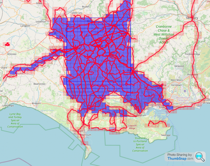
I went for a ride today (62km) to try and grab a couple of tiles. The Garmin outage meant I couldn't quite get the route I was thinking of, as was aiming to increase max square but must have missed one. Ah well, next time! I currently have 5x 20x20 squares overlapping in my cluster. It'd be much easier if the ridgeway had more roads across it!
2807 tiles, average of 6.311 km per tile (+7, up from 2802 and + 0.028km per tile)
Max square 20x20 (no change)
Max Cluster: 629 (+5 from 624)
Veloviewer score - 99.425 (up from 99.425)
2807 tiles, average of 6.311 km per tile (+7, up from 2802 and + 0.028km per tile)
Max square 20x20 (no change)
Max Cluster: 629 (+5 from 624)
Veloviewer score - 99.425 (up from 99.425)
flight147z said:
Make sure you watch a video on how the navigation works on YouTube before you buy anything. Personally I couldn't use the 130 for navigating - it doesn't even have a map
I had a Garmin Forerunner 310 that was like that, it was just a wiggly line on the screen. If you went off route, it would say off route, and you could see the line if you weren't far away, but I never figured out which way to turn to get back on track!Daveyraveygravey said:
flight147z said:
Make sure you watch a video on how the navigation works on YouTube before you buy anything. Personally I couldn't use the 130 for navigating - it doesn't even have a map
I had a Garmin Forerunner 310 that was like that, it was just a wiggly line on the screen. If you went off route, it would say off route, and you could see the line if you weren't far away, but I never figured out which way to turn to get back on track!flight147z said:
Daveyraveygravey said:
flight147z said:
Make sure you watch a video on how the navigation works on YouTube before you buy anything. Personally I couldn't use the 130 for navigating - it doesn't even have a map
I had a Garmin Forerunner 310 that was like that, it was just a wiggly line on the screen. If you went off route, it would say off route, and you could see the line if you weren't far away, but I never figured out which way to turn to get back on track!I recall several of us left the route of the PistonHeads Tour De France Cambridge to London ride. A couple of us had the route in breadcrumb trail form on our Garmins, but a complex roundabout caused confusion, with several roads at a similar angle. We got back on route fairly shortly afterwards, but it was annoying.
My issue with my Edge 500 was that it would happily draw the map when the page cycled through when it was a turn-free section. But as soon as I needed to rely on it to "call" a turn, the damned thing would refuse to redraw the breadcrumb trail, causing me to miss a turn and have to go about again. I seldom bother with digital routes now, and carry a paper map instead.
ukbabz said:
I went for a ride today (62km) to try and grab a couple of tiles. The Garmin outage meant I couldn't quite get the route I was thinking of, as was aiming to increase max square but must have missed one. Ah well, next time! I currently have 5x 20x20 squares overlapping in my cluster. It'd be much easier if the ridgeway had more roads across it!
2807 tiles, average of 6.311 km per tile (+7, up from 2802 and + 0.028km per tile)
Max square 20x20 (no change)
Max Cluster: 629 (+5 from 624)
Veloviewer score - 99.425 (up from 99.425)
By 'eck our kid! Garmin outage? Can't get the route you wanted?2807 tiles, average of 6.311 km per tile (+7, up from 2802 and + 0.028km per tile)
Max square 20x20 (no change)
Max Cluster: 629 (+5 from 624)
Veloviewer score - 99.425 (up from 99.425)
Join us in the dim and distant dark ages with some decidedly low tech alternatives...

Edited by yellowjack on Thursday 30th July 00:59
Solocle said:
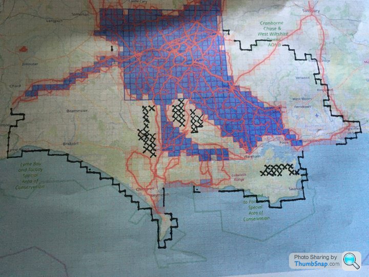
We've got quite a bit of overlap going on there!That three-tile 'L' of mine takes in the South Dorset Ridgeway above the Osmington White Horse. I ditched it off my last ride in favour of rolling down the hill to the chippie in Preston. And three times now I've set out with a plan to annex Portland as a part of my Red Square empire, and three times I've been distracted by "Ooh! A bridleway! I wonder where that goes?" type stuff and ended up further north than planned. I suppose that's the one drawback of old fashioned paper maps - at least with a GPS route you either have to follow it or guess where fresh tiles are. With the OS maps the temptation is always there to strike out in a different direction based on nothing but a whim when you pass a bridleway entry point and check to see where it leads. That's what has been killing my average speed on longer rides - I promise myself I'll take care of my road bike and stay on tarmac, but then soon enough I'm trundling down concrete farm roads that give way to gravel and hard-packed dirt, and that then dwindle down into bridleways and even footpaths. By the time I get back onto a road the damage is pretty much done and the planned destination goes out of the window. But exploring is fun, so no ride has been "ruined" by such distractions, and Portland will be there just the same next time I'm down that way...
Edit:
My goal right now is to ride as much of Portland as I can with dry feet, then have a straight line of tiles northwards, straddling the SY65 easting at least as far as Dorchester. Then I'll concentrate on filling in all the tiles east of that line to Southampton Water. After that I'm not sure. Perhaps I'll strike out north, and fill in some of the empty blocks of tiles toward Shaftesbury and Warminster. That's where I'll discover the northern limit of exploitation (artillery ranges at Larkhill and the Imber live fire area). That's the point where I think i'll go back to working on my Max Square, working north to south too so as to make a huge increase in Max Square size when I fill in those last few tiles in the middle. Addictive isn't the word for this nonsense right now. I'm obsessed. When I'm not riding I'm poring over maps planning to ride!
Edited by yellowjack on Thursday 30th July 09:52
Oof good work with the manual mapping! I tend to make a route using online tools and either download onto my garmin or go from memory with usually good results!
It is lovely to ride down around Swanage if not a tad lumpy. I still think you should get a sea kyak or similar for the missing sea tiles!
It is lovely to ride down around Swanage if not a tad lumpy. I still think you should get a sea kyak or similar for the missing sea tiles!
Yeah, I, umm, have a lot of rides already planned.
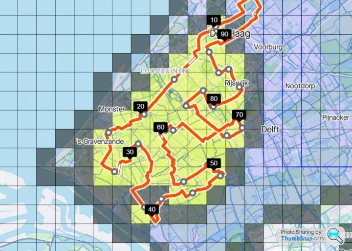
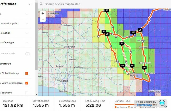
I managed to wangle this one so that the two sections on the A37 are generally downhill:
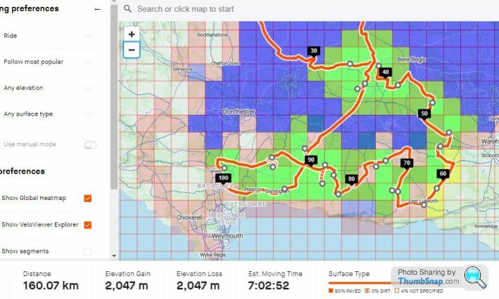
Here's how I deal with the 2 ridgeway tiles I've left to do, along with some of Purbeck:
I do have the Purbecks (OL15) OS map, but I generally prefer to try and assess the surface from Street View or Google Satellite. Still doesn't stop my GPS routes from going down bridleways.... but I'm trying to reduce that.
I managed to wangle this one so that the two sections on the A37 are generally downhill:
Here's how I deal with the 2 ridgeway tiles I've left to do, along with some of Purbeck:
I do have the Purbecks (OL15) OS map, but I generally prefer to try and assess the surface from Street View or Google Satellite. Still doesn't stop my GPS routes from going down bridleways.... but I'm trying to reduce that.
Edited by Solocle on Thursday 30th July 10:46
Solocle said:
Yeah, I, umm, have a lot of rides already planned...
Here's how I deal with the 2 ridgeway tiles I've left to do, along with some of Purbeck:
For the coastal tiles along the A353, there's a bit of out-and back to be done if you don't want to take a stroll with the bike along the coast path. Don't bother with the road down to the PGL Adventure Centre in Osmington (signed for village hall too) though. It's gated so you can't get far enough along to nab the tile. Get down to the Riviera Hotel (Bowleaze Cove Way) and access the grassed area above the hotel for that one. I learned the hard way on that coastal strip, and ended up walking my bike up and down steps quite a lot between Ringstead Bay and Osmington Mills. Similar results can, I think, be achieved by just trundling down the 'T' roads to the coast at each point along the way, thereby sticking to tarmac for the most part.Here's how I deal with the 2 ridgeway tiles I've left to do, along with some of Purbeck:
I do as you do, and suss out some of my plans on Strava routes (easiest way of accurately predicting mileage) or Google Earth/Streetview. I just don't bother saving the routes as my Gamins aren't reliable enough on their own for navigation, and don't afford me the flexibility I like to change destination while already out on the route.
yellowjack said:
For the coastal tiles along the A353, there's a bit of out-and back to be done if you don't want to take a stroll with the bike along the coast path. Don't bother with the road down to the PGL Adventure Centre in Osmington (signed for village hall too) though. It's gated so you can't get far enough along to nab the tile. Get down to the Riviera Hotel (Bowleaze Cove Way) and access the grassed area above the hotel for that one. I learned the hard way on that coastal strip, and ended up walking my bike up and down steps quite a lot between Ringstead Bay and Osmington Mills. Similar results can, I think, be achieved by just trundling down the 'T' roads to the coast at each point along the way, thereby sticking to tarmac for the most part.
I already have the coastal tiles... my school did a coastal walk from Durdle Door to Overcombe in Year 8 
EDIT:
And plop
Max square 17 -> 18 (multiple of them!)
Max cluster 559 -> 599 (was 600 too much to ask!?)
Edited by Solocle on Thursday 30th July 19:48
I've been trying to colour in a few bits in my area before pushing out the max square. I've coloured in a good chunk of South Oxfordshire and most of the area between the m40 and m4 east of Oxford until the ridge of chilterns.
There's at least 4 overlapping 20x20 squares so should be able to get to a 24x24 square with a concerted effort!
Explorer score:
2812 tiles (+3 from 2809 tiles,) average of 6.354 km per tile (+0.02km per tile from 6.334)
Max square 20x20 (no change)
Max Cluster: 640 (+11 up from 629
Veloviewer Score - 99.430 (+0.001)
Gassing Station | Pedal Powered | Top of Page | What's New | My Stuff