Veloviewer. Who is using it, and what do you get from it?
Discussion


Solocle said:
Yeah, you feed it a route, it'll produce an activity! So, the strava route tool, with the veloviewer extension, as long as you know which tiles you nabbed, will be fine.
I used that approach to see which tiles a prospective route would tick off, you can delete the activity, and the tiles will go back to unvisited. Although it did once confuse the veloviewer extension, a new activity solved that one.
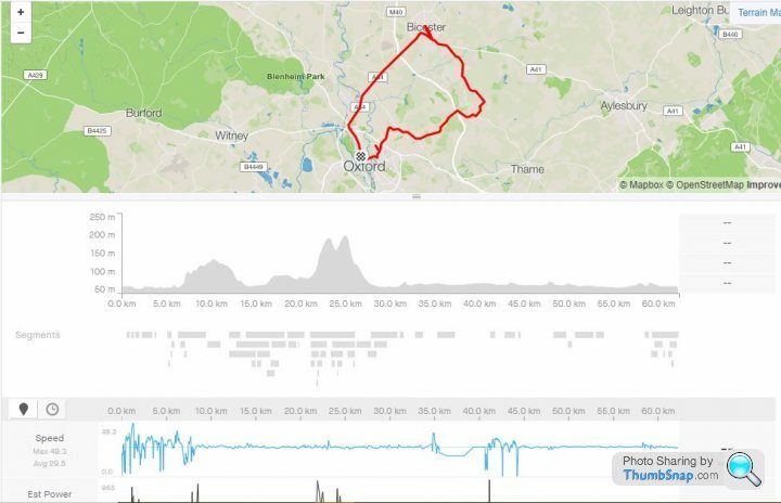
Here's one I made earlier. I had little snippets of Strava, but the app kept dropping out, so I filled in the gaps, then joined it all together. Obviously, speed isn't very realistic, but it gets the job done.
Your assistance greatly appreciated on this. I had no idea that site existed. Shouldn't really be using it to "fake a ride" like this, but this is bothering me more than it ought to. So I've managed to sort it out, not as complex as I feared. I think I've nabbed a couple of extra tiles where the "fake" route clipped corners of unridden tiles. No great shakes, I fully expect to ride most, if not all, of these tiles again at some point. My obsessive behaviour is worse than I thought it was though. Time to take a long hard look at myself to see if I can't manage to do a "hard reset" on what makes me tick!I used that approach to see which tiles a prospective route would tick off, you can delete the activity, and the tiles will go back to unvisited. Although it did once confuse the veloviewer extension, a new activity solved that one.
Here's one I made earlier. I had little snippets of Strava, but the app kept dropping out, so I filled in the gaps, then joined it all together. Obviously, speed isn't very realistic, but it gets the job done.
Some Gump said:
Yellowjack - can you plug the watch into the computer and see /garmin/activities?
If so, you could manually copy / paste onto computer and save as a .fit file. Then upload to strava from there?
No, because it's wireless ANT+ connection only for file transfer. Nowhere to plug a data cable in.If so, you could manually copy / paste onto computer and save as a .fit file. Then upload to strava from there?
First "casualty" of my VeloViewer tile hunting obsession yesterday afternoon. Two holes in my PistonHeads cycle jersey from a barbed wire fence I had to cross in order to access a beach to get down to the mean low water line. I foolishly tried the "boxing ring" technique to get between strands, but they were too close together. Luckily I found a spot where I could get over the fence from the other side on the way back. I didn't get to low water mark, as the tide wasn't out, but used the 10-figure grid reference from my Garmin watch to confirm that I didn't need to remove my shoes and socks and get wet feet to "collect" the tile! I think this episode might well indicate that I've taken tile hunting too far. Hiding a £2.5k road bike in a ditch next to a Southern Water foul water outflow pipe and scaling fences to get to the seashore in order to 'stick a flag' (or more accurately place a pixel) into a tile on a map. The word "idiot" springs to mind... 
57 miles to net just three tiles in the end. The other two weren't any more sensible to be fair. A nasty loose gravel road to a nature reserve and sailing club car park at the end of Needs Ore Point at the mouth of the Beaulieu River. It'll soon be time to push further, possibly onto the Southampton side of the Solent next. And maybe try to work out a way to get onto the Fawley refinery site too.
Maybe I should just roll up to the gate, explain honestly what I want to do, and ask security nicely... ...it's either that, or buy a kayak!
57 miles to net just three tiles in the end. The other two weren't any more sensible to be fair. A nasty loose gravel road to a nature reserve and sailing club car park at the end of Needs Ore Point at the mouth of the Beaulieu River. It'll soon be time to push further, possibly onto the Southampton side of the Solent next. And maybe try to work out a way to get onto the Fawley refinery site too.
Maybe I should just roll up to the gate, explain honestly what I want to do, and ask security nicely...
...it's either that, or buy a kayak!Solocle said:
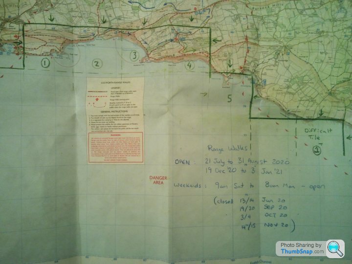
Yeah. The Imber Range and Larkhill Artillery Impact Area would tend to limit expansion in that direction. I think there are one or two "impossible" tiles in the Gunnery School Ranges at Lulworth too, although they are closer to public roads so an accidental wander onto the range when it's not in use wouldn't seem to be quite as suicidal as riding across a High Explosive artillery impact area... 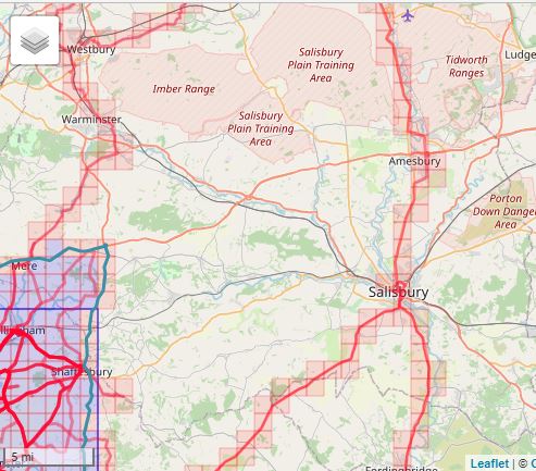

Solocle said:

On the Lulworth ranges, the blue tiles are definitely accessible by road, the orange are definitely accessible by the coast path. That final tile - there's some form of road going through it, but you might well hit a no admittance barrier, it's hard to tell.
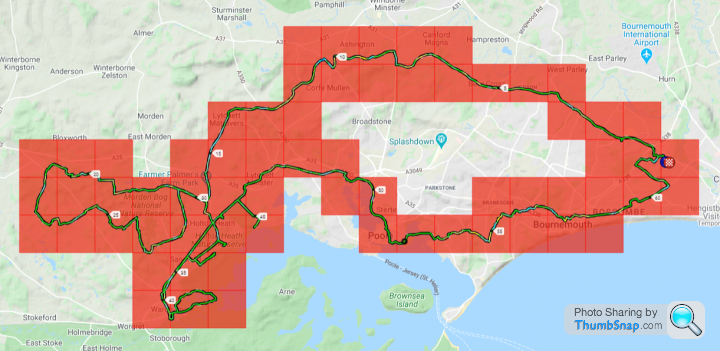
100 km and a paltry 6 tiles for me today. But to be fair they were difficult tiles around the Wareham side of Poole Harbour. Shredded legs, some "bike dumped under a tree and walk to claim the tile", and riding a road bike on what was basically a single-track footpath. Done now, though. No need to revisit any of those particular tiles.
Another 6 targeted around Arne and the Wytch Heath oil field will leave only 4 to claim on Brownsea Island. When that opens again I'll nip over on the ferry and walk the perimeter of the island to nab those. Then it's down to the south coast of Purbeck for a couple of dozen tiles. That'll need the chain ferry to open again, so that I can get across more efficiently with a MTB or gravel bike.
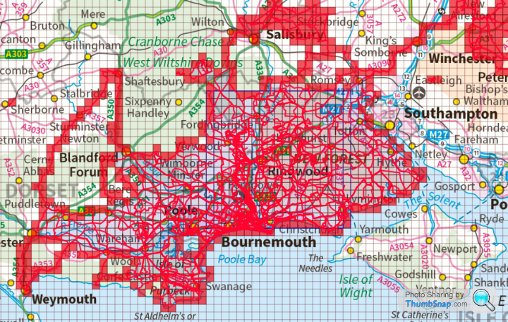
It's good fun, all this tile hunting. I think it makes sense to get some of the tougher tiles out of the way before "bulk riding" the easier ones to complete the jigsaw puzzle. No sense in setting your heart on a particular tile to extend your Max Square then getting to it to find it's surrounded by 10 ft fences (Holton Heath Cordite Factory - I'm looking at you here...). I found a way around Holton Heath in the end (which required a wee bit of trespassing if I'm honest). Once the Isle Of Purbeck is "coloured in" I'm going to have to concentrate on expanding northwards to Salisbury to start with. I'm going to ride some long routes then, to join up some of my outliers like the Imber Range Road and a group of tiles ridden from Tedworth House to Ludgershall.
I'm also looking at routes that will join my cluster around Bournemouth to my Max Cluster set when I lived in (and centred on) Farnborough. That would mean a few long rides up to Winchester/Alresford from Bournemouth. This warm, dry weather is a real Godsend for longer cycling routes at the moment. It's almost a shame that the world is coming out of lockdown and traffic is building once again. I was quite enjoying the solitude while everyone was hunkered down at home...
Another 6 targeted around Arne and the Wytch Heath oil field will leave only 4 to claim on Brownsea Island. When that opens again I'll nip over on the ferry and walk the perimeter of the island to nab those. Then it's down to the south coast of Purbeck for a couple of dozen tiles. That'll need the chain ferry to open again, so that I can get across more efficiently with a MTB or gravel bike.
It's good fun, all this tile hunting. I think it makes sense to get some of the tougher tiles out of the way before "bulk riding" the easier ones to complete the jigsaw puzzle. No sense in setting your heart on a particular tile to extend your Max Square then getting to it to find it's surrounded by 10 ft fences (Holton Heath Cordite Factory - I'm looking at you here...). I found a way around Holton Heath in the end (which required a wee bit of trespassing if I'm honest). Once the Isle Of Purbeck is "coloured in" I'm going to have to concentrate on expanding northwards to Salisbury to start with. I'm going to ride some long routes then, to join up some of my outliers like the Imber Range Road and a group of tiles ridden from Tedworth House to Ludgershall.
I'm also looking at routes that will join my cluster around Bournemouth to my Max Cluster set when I lived in (and centred on) Farnborough. That would mean a few long rides up to Winchester/Alresford from Bournemouth. This warm, dry weather is a real Godsend for longer cycling routes at the moment. It's almost a shame that the world is coming out of lockdown and traffic is building once again. I was quite enjoying the solitude while everyone was hunkered down at home...
Some Gump said:
Yellowjack, what you really need is 2-3 rides to connect your 2 clusters to form 1 uber cluster. =)
If I manage to get my 55 miler in this week, I'll have my square nicely expanded. Managed to tick an extra bit off today, which involved hammering a set of carbon clinchers wearing 23c down several miles of off road path. Strava routes said it was a road!
I'm trying to do all of mine from home, rather than "cheating" and driving to the edge and colouring a bit in. Only exceptions will be some of the peak district hills where it's impossible to road bike up them. Hell, for some of them I don't think you're even allowed to cycle them even if you had the skill. I'll probably walk up them with the kids - but my moral compass says that's fair game.
On that note...If I manage to get my 55 miler in this week, I'll have my square nicely expanded. Managed to tick an extra bit off today, which involved hammering a set of carbon clinchers wearing 23c down several miles of off road path. Strava routes said it was a road!
I'm trying to do all of mine from home, rather than "cheating" and driving to the edge and colouring a bit in. Only exceptions will be some of the peak district hills where it's impossible to road bike up them. Hell, for some of them I don't think you're even allowed to cycle them even if you had the skill. I'll probably walk up them with the kids - but my moral compass says that's fair game.
Today's ride, ticking off only six 'new' tiles.

And the two clusters that need joining, along with those outlying tiles around Tidworth and Warminster.
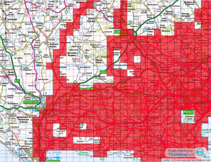
I've been quiet on here, and had a week off the bike again. But I've been out on my MTB on the coast path, and my road bike around Puddletown Forest, picking off tiles...
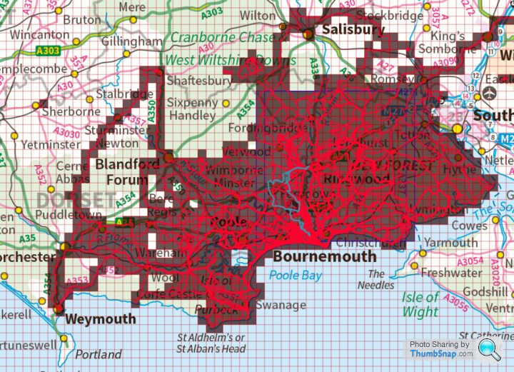
...I'm trying to complete the coast from Fawley Refinery to Portland Bill, then I'll move inland and "colour in" Purbeck, before extending up to Salisbury and across to Shaftesbury. Holding me up now is Brownsea Island. A neat square of 4 tiles centred on the island, only accessible when the NT open it and the ferries are running. Unless I get a kayak!
I did most of yesterday's ride out Dorchester way with a broken rear shifter cable, so running as a two-speed!
https://www.strava.com/activities/3689782202
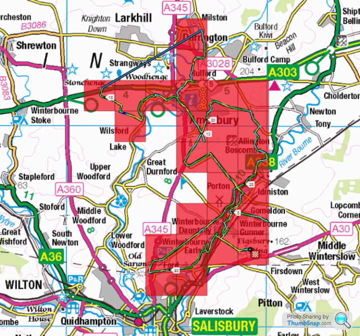
Today's result. I drove up to Figsbury Ring car park (take a Dakar-prepped Bowler for the "road" up to the car park!) and rode up to Stonehenge, and completed the lap of Boscombe Down to get that out of the way. 23 new tiles, and 3 covering old ground. Should have been 4 more, at least, but I stopped my GPS watch and failed to restart it for a while.
I took my Cannondale 'Backroads' with HeadShok. The HeadShok itself sounds a bit past it's best, and the bike is heavy. But it rode nicely on the byways and bridleways up there. As usual, I'd planned to do more. Including linking up my tiles around Tidworth with the Salisbury cluster. And as usual I left home rather later than planned and therefore ran out of time. Still, it's an excuse to go back again...
Edited by yellowjack on Monday 29th June 23:15
No time for a longer planned ride, and the army tank ranges at Lulworth Gunnery School had some of the roads I needed to 'nab' 5 tiles closed anyway. So I moved on down to Kimmeridge, east of the Lulworth Range boundary, and got four tiles down there...
...which, rather unexpectedly, means that my Max Cluster has increased from 636 to 639. Better yet, though. It means that the Max Cluster I have created since April last year, centred on Bournemouth, is now larger than the "old" Max Cluster centred on Farnborough. And that one took me six years to create.

Now, if I can manage to link the two clusters up, I'll more than double the size of it/them. And hopefully someone at the National Trust will come up with a plan to reopen Brownsea Island some time soon, because the four tiles covered by the island will be worth a 12 tile increase to my Max Cluster.
Sadly, no increase to my Max Square. Filling in the gaps on Purbeck does nothing to help expand my Max Square, but it's good fun all the same...
...which, rather unexpectedly, means that my Max Cluster has increased from 636 to 639. Better yet, though. It means that the Max Cluster I have created since April last year, centred on Bournemouth, is now larger than the "old" Max Cluster centred on Farnborough. And that one took me six years to create.
Now, if I can manage to link the two clusters up, I'll more than double the size of it/them. And hopefully someone at the National Trust will come up with a plan to reopen Brownsea Island some time soon, because the four tiles covered by the island will be worth a 12 tile increase to my Max Cluster.
Sadly, no increase to my Max Square. Filling in the gaps on Purbeck does nothing to help expand my Max Square, but it's good fun all the same...
ukbabz said:
yellowjack said:
Now, if I can manage to link the two clusters up, I'll more than double the size of it/them. And hopefully someone at the National Trust will come up with a plan to reopen Brownsea Island some time soon, because the four tiles covered by the island will be worth a 12 tile increase to my Max Cluster..
Not fancy a swim? ;-) 
Another big one last Thursday. Another Garmin failure.
So another Strava upload using GOTOES ( https://gotoes.org/gotoes/strava/Add_Timestamps_To... ) site to add time stamps to a planned route to recreate the ride and claim the tiles. 125 miles ridden in total, over 11 hours moving time, and I wasn't back until 0215 hours, much to the annoyance of my wife.
The ForeRunner 910XT just doesn't seem able to cope with big ride files. This time Garmin Express said "there was an error syncing to Garmin Connect". No explanation of what was the nature of the error, nor any suggestions of how to fix it. Repeated attempts at uploading the file were driving me nuts, so i've wiped the activity from the watch and used the Strava Routes feature to create the route I rode, and GOTOES to add time stamps.
A bogus KOM came up, so i've had to flag the activity. I'm not sure if this quarantines the whole ride though? I want to claim the Veloviewer tiles and the mileage, I don't give a fig about leaderboards. I seem to have the tiles, not sure if the miles count toward my personal totals.
It was a daft ride. Planned to go to Portland and back from Bournemouth, all on the road. Ended up pissing about on byways and bridleways, and even walking sections of the coast path near Ringstead/Osmington. This meant I hadn't time or daylight to get back, so I binned Portland off for another day. Hard work. Hot too, when the sun came out from behind the clouds in the afternoon. The off-roading did deliver 28 tiles though, and left gaps that are either unrideable anyway (Lulworth Range Path, for example, forbids cycling) or are asphalt roads so filling in those gaps should be easier next time. A disappointing sounding 11.2 mph average speed according to the Activity page on the watch, but when I think about all the bridleways and footpaths I had to push the bike along, it doesn't seem as disappointing after all.
Strava link here... https://www.strava.com/activities/3788187759
I'm going to have to do something about the Garmin reliability issues on longer rides though. Maybe get my Edge500 repaired, or buy a new Garmin or perhaps defect to a Wahoo device? If the watch can't cope with larger data files it won't be much use to me, really...
ukbabz said:
That's frustrating, and I agree I think you're finding a limit of the watches.
For older garmin edge models it seems wahoo had the edge, however if you go for the 530/830/1030 they seem to have gained the edge again....
Additional frustration now! For older garmin edge models it seems wahoo had the edge, however if you go for the 530/830/1030 they seem to have gained the edge again....
Garmin's servers are down. I can't even attempt to upload yesterday's 126 miler until the servers are back up again. Watch was OK battery wise, a two-hour ride the day before uploaded OK after i did some "spring cleaning" of Garmin files and folders. That two-hour ride, and 12 hours or so yesterday meant the watch was down to 5% battery life remaining when I plugged it in to charge this morning. It remains to be seen whether the data will transfer and end up as a useable FIT file though.
I also ran my Edge 500 as a back-up. I didn't turn that on until I reached "new tile territory" though. It didn't quite last until the last of the "new tiles". A full charge lasted around 8 hours I think, including all the map-reading auto-pause periods. I can't find anything on the Garmin UK site about repair (or replace with refurbished unit) for the Edge 500, so I've been Googling for a repair company I can send the Edge 500 to for a new battery and a new rear case (the ¼ turn mount is broken). I haven't connected the Edge 500 so no idea if that will upload direct to Strava without the Garmin servers. It's tempting, even though it would only be half a ride, just to see what tiles I managed to bag.
Big ride out, over to the Blandford area (but not into Blandford Forum itself). Then wiggling my way down to Dorchester, and eventually on to Preston on the outskirts of Weymouth (for chips!) before coming back via Winfrith and Wareham. I had a 1:25,000 scale OS map for the bits south of Dorchester, and I also had a 1:50,000 scale map of Salisbury and The Plain. But all I had to help with the infill bit between Blandford and Dorchester was a fablon-covered page torn from an old AA road atlas! Hardly the most reliable mapping when it comes to VV tiling...

I'd also sworn that I'd stick to tarmac roads this time, and get down to Portland. In the end I went too far north, and was enticed onto bridleways and byways again (I don't think I'll ever learn) which killed my average speed. So time ran out once again, and after finishing at 3am last time I did a 200 km ride, this time I finished at a slightly more civilised 0030hrs.
I'm now champing at the bit to get the watch data uploaded, if only to see if the damned thing works. And the Garmin servers are still down!!!

Yup. I'm confident the Edge 500 can upload direct to Strava. But I'd rather the whole ride was up there. I suppose the solution will be to upload the Edge 500's portion of the ride, then delete that activity if/when the ForeRunner 910XT provides the data through the server for the full ride.
I've just been looking at new Garmins on the Halfords (  ) website.
Edge 130 for £99
Edge 520 for £199
One has breadcrumb trail nav, the other a map-based full nav system. Plus other features I'll probably not use. Either seems to be good for 15 hours, and I'm not so much into following set routes anyway. I'll always be that rider with an OS map in his jersey pocket, I think. Both should be able to upload direct to Strava, bypassing this Garmin server issue. It's either that or first get a quote for repair of my edge 500 with new battery and rear case. I suppose the quote for that will see whether it's just better to 'bite the bullet' and buy a new GPS for the first time ever. I've got all the cadence sensors and HRMs already for Garmin (presuming backward compatibility) so paying extra for a bundle isn't necessary. But the one thing that's essential for VV tiling is a reliable GPS unit with decent battery life. It's about time I invested in some reliability instead of riding with my fingers crossed and getting frustrated with the ANT+ upload system of the ForeRunner 910XT.
) website.Edge 130 for £99
Edge 520 for £199
One has breadcrumb trail nav, the other a map-based full nav system. Plus other features I'll probably not use. Either seems to be good for 15 hours, and I'm not so much into following set routes anyway. I'll always be that rider with an OS map in his jersey pocket, I think. Both should be able to upload direct to Strava, bypassing this Garmin server issue. It's either that or first get a quote for repair of my edge 500 with new battery and rear case. I suppose the quote for that will see whether it's just better to 'bite the bullet' and buy a new GPS for the first time ever. I've got all the cadence sensors and HRMs already for Garmin (presuming backward compatibility) so paying extra for a bundle isn't necessary. But the one thing that's essential for VV tiling is a reliable GPS unit with decent battery life. It's about time I invested in some reliability instead of riding with my fingers crossed and getting frustrated with the ANT+ upload system of the ForeRunner 910XT.
OK then.
Decision made. Edge500 partial GPS trace uploaded. Details below...

Yesterday's hilly route through rural Dorset.
How it looked before this ride.

How it looks following the Edge 500 data upload.
There should be four or possibly five additional tiles to add if/when the data comes out of the 910XT watch, but the bulk (39) of the new tiles are all present and correct, with no need to fudge things with a reconstruction using digital trickery.
Decision made. Edge500 partial GPS trace uploaded. Details below...
Yesterday's hilly route through rural Dorset.
How it looked before this ride.
How it looks following the Edge 500 data upload.
There should be four or possibly five additional tiles to add if/when the data comes out of the 910XT watch, but the bulk (39) of the new tiles are all present and correct, with no need to fudge things with a reconstruction using digital trickery.
Solocle said:
Hmm, I'd go for a 530 if possible. There's the EveryTile app for the garmins... but I run a Wahoo Roam, and the quality of the maps was a useful feature when I found the bridleway I'd intended on following completely impassable.... I was able to get back to my route and make sure that I hit the requisite tiles.
£232.69 is more than I can afford to spend on a GPS though. And it seems to have a lot of features I probably wouldn't use. The Edge 130 seems to be about where I can stretch to right now, sadly. I mean, there's not a huge jump between the 520 and the 530 so the extra £32.69 would make sense. But the gulf in price between the 130 and any of the 500 series would make it a difficult bridge to cross.Edit:
Anyone know for sure that you can upload direct to Strava from the Edge 130? It doesn't tell me in the various product descriptions, and my laptop is overheating intermittently so reading through an entire DC rainmaker review is nigh on impossible!
Edited by yellowjack on Friday 24th July 14:50
flight147z said:
Daveyraveygravey said:
flight147z said:
Make sure you watch a video on how the navigation works on YouTube before you buy anything. Personally I couldn't use the 130 for navigating - it doesn't even have a map
I had a Garmin Forerunner 310 that was like that, it was just a wiggly line on the screen. If you went off route, it would say off route, and you could see the line if you weren't far away, but I never figured out which way to turn to get back on track!I recall several of us left the route of the PistonHeads Tour De France Cambridge to London ride. A couple of us had the route in breadcrumb trail form on our Garmins, but a complex roundabout caused confusion, with several roads at a similar angle. We got back on route fairly shortly afterwards, but it was annoying.
My issue with my Edge 500 was that it would happily draw the map when the page cycled through when it was a turn-free section. But as soon as I needed to rely on it to "call" a turn, the damned thing would refuse to redraw the breadcrumb trail, causing me to miss a turn and have to go about again. I seldom bother with digital routes now, and carry a paper map instead.
ukbabz said:
I went for a ride today (62km) to try and grab a couple of tiles. The Garmin outage meant I couldn't quite get the route I was thinking of, as was aiming to increase max square but must have missed one. Ah well, next time! I currently have 5x 20x20 squares overlapping in my cluster. It'd be much easier if the ridgeway had more roads across it!
2807 tiles, average of 6.311 km per tile (+7, up from 2802 and + 0.028km per tile)
Max square 20x20 (no change)
Max Cluster: 629 (+5 from 624)
Veloviewer score - 99.425 (up from 99.425)
By 'eck our kid! Garmin outage? Can't get the route you wanted?2807 tiles, average of 6.311 km per tile (+7, up from 2802 and + 0.028km per tile)
Max square 20x20 (no change)
Max Cluster: 629 (+5 from 624)
Veloviewer score - 99.425 (up from 99.425)
Join us in the dim and distant dark ages with some decidedly low tech alternatives...

Edited by yellowjack on Thursday 30th July 00:59
Solocle said:
We've got quite a bit of overlap going on there!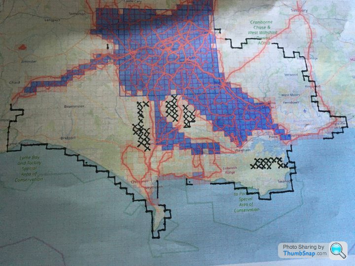
That three-tile 'L' of mine takes in the South Dorset Ridgeway above the Osmington White Horse. I ditched it off my last ride in favour of rolling down the hill to the chippie in Preston. And three times now I've set out with a plan to annex Portland as a part of my Red Square empire, and three times I've been distracted by "Ooh! A bridleway! I wonder where that goes?" type stuff and ended up further north than planned. I suppose that's the one drawback of old fashioned paper maps - at least with a GPS route you either have to follow it or guess where fresh tiles are. With the OS maps the temptation is always there to strike out in a different direction based on nothing but a whim when you pass a bridleway entry point and check to see where it leads. That's what has been killing my average speed on longer rides - I promise myself I'll take care of my road bike and stay on tarmac, but then soon enough I'm trundling down concrete farm roads that give way to gravel and hard-packed dirt, and that then dwindle down into bridleways and even footpaths. By the time I get back onto a road the damage is pretty much done and the planned destination goes out of the window. But exploring is fun, so no ride has been "ruined" by such distractions, and Portland will be there just the same next time I'm down that way...
Edit:
My goal right now is to ride as much of Portland as I can with dry feet, then have a straight line of tiles northwards, straddling the SY65 easting at least as far as Dorchester. Then I'll concentrate on filling in all the tiles east of that line to Southampton Water. After that I'm not sure. Perhaps I'll strike out north, and fill in some of the empty blocks of tiles toward Shaftesbury and Warminster. That's where I'll discover the northern limit of exploitation (artillery ranges at Larkhill and the Imber live fire area). That's the point where I think i'll go back to working on my Max Square, working north to south too so as to make a huge increase in Max Square size when I fill in those last few tiles in the middle. Addictive isn't the word for this nonsense right now. I'm obsessed. When I'm not riding I'm poring over maps planning to ride!
Edited by yellowjack on Thursday 30th July 09:52
Gassing Station | Pedal Powered | Top of Page | What's New | My Stuff