Veloviewer. Who is using it, and what do you get from it?
Discussion


Some Gump said:
That feels pretty obvious to me - head out south west so that ehen you join your new cluster to existing, you get the biggest total. =)
Guess that makes sense!yellowjack said:
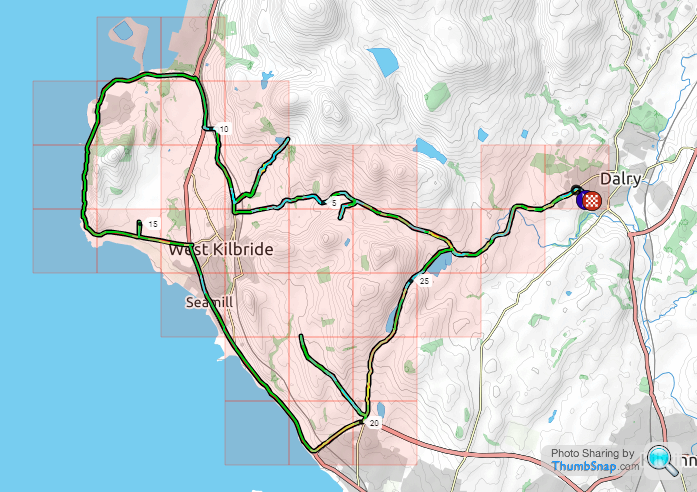
I only went and got that damned tile today!
Well done! Glad there aren't many tiles like that about me as far as I can see so far, just really s tty ground that's difficult to get to.
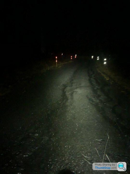
Last day of my holiday today so went out and grabbed some more tiles, first time driving to the start of a ride to prevent having to cover the same 8 mile ride out and back again as it's beginning to eat into cycle time too much.
VV score: 85.007 (Up from 84.996)
290 tiles (Up from 261 tiles), average of 2.899 (down from 3.114) mi per tile
Max square: 10x10 (No change)
Max cluster: 137 (Up from 124)
Eddington Ride: 22 (No change)
Failed to capture 2 tiles on the route, 1 due to Komoot shortening a detour without me realising and the other missed by a dodgy GPS signal.
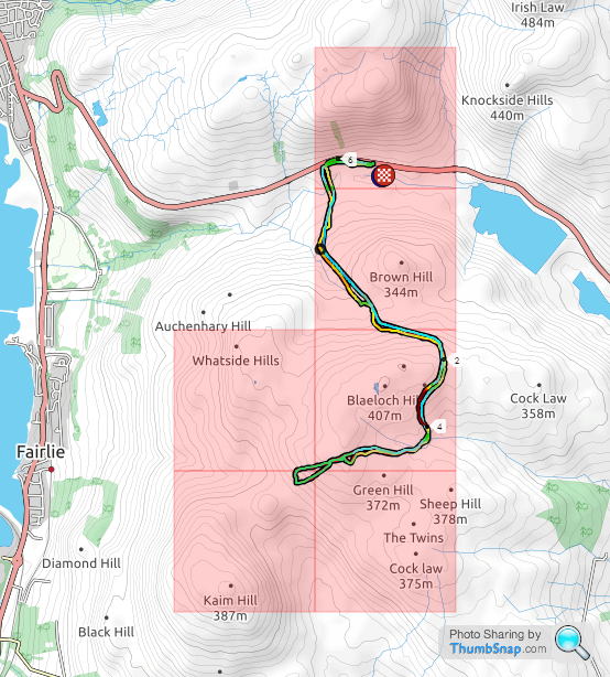
So I'll need to revisit these on a one off one night after work this week I think. Map as it stands with the next trip's targeted tiles highlighted. The 2 northerly ones are hike a bike.
yellowjack said:
I only went and got that damned tile today! https://www.strava.com/activities/4217067952

Perenco's gate was left open and I got in far enough to claim the tile. Can't agree on the "not obviously private" bit. It's clear that you're not meant to be in Perenco's depot. But after sniffing around at Jenkins Marine and seeing that they had too much going on in the yard, I doubled back to Perenco. No one in the yard, and the office didn't look busy either so I risked it, sneaked behind a tanker trailer, and rode the gravel down past the boats to the sea wall. Didn't stop, just spun round and came back out again. As I did so, an older chap with a large belly was striding across the yard pulling on a hi-vis waistcoat and shouting at me. I ignored him, on the grounds that I was already leaving, and carried on back out of the gate. Done now though, so no need to ever go back into the port area.
48 tiles ridden, but only three new ones.
Happy to have closed up three annoying gaps in my Max cluster though.
Fair play, when I did it, I didn't realize that it was a depot or anything!Perenco's gate was left open and I got in far enough to claim the tile. Can't agree on the "not obviously private" bit. It's clear that you're not meant to be in Perenco's depot. But after sniffing around at Jenkins Marine and seeing that they had too much going on in the yard, I doubled back to Perenco. No one in the yard, and the office didn't look busy either so I risked it, sneaked behind a tanker trailer, and rode the gravel down past the boats to the sea wall. Didn't stop, just spun round and came back out again. As I did so, an older chap with a large belly was striding across the yard pulling on a hi-vis waistcoat and shouting at me. I ignored him, on the grounds that I was already leaving, and carried on back out of the gate. Done now though, so no need to ever go back into the port area.
48 tiles ridden, but only three new ones.
Happy to have closed up three annoying gaps in my Max cluster though.
Edited by yellowjack on Monday 19th October 22:19
Regarding Lytchett Minster, perhaps I need to get Shephard's Bush tiled to make the full package


Comacchio said:
Failed to capture 2 tiles on the route, 1 due to Komoot shortening a detour without me realising and the other missed by a dodgy GPS signal.
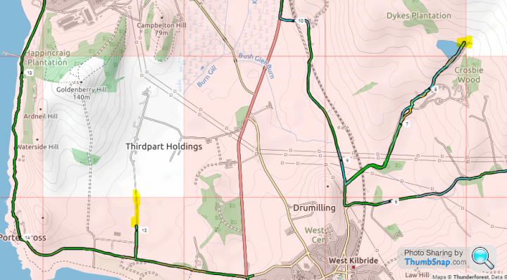
Rectified this tonight after work: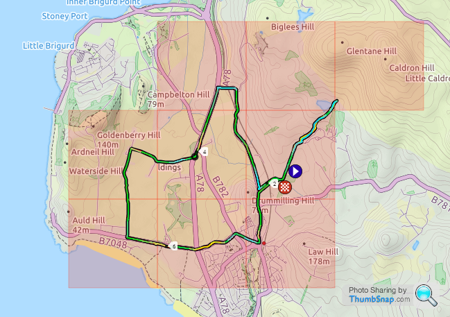
VV score: 85.034 (Up from 84.007)
292 tiles (Up from 290 tiles), average of 2.906 (up from 2.899) mi per tile
Max square: 10x10 (No change)
Max cluster: 147 (Up from 137)
Eddington Ride: 22 (No change)
Map:
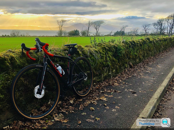
Will try to get the missing 2 northerly tiles on Saturday. Lovely sky this evening over the Isle of Arran:
loudlashadjuster said:
Would it be cricket to keep your Garmin on on the ferry to Millport to try and increase your max cluster when you cycle round Cumbrae? 
I've considered doing that down on the south coast. Could have saved myself being shouted at in the Port Of Poole if I'd just started my Garmin on the Quayside a week before when I visited Brownsea Island and missed claiming a tile by a matter of yards. The ferry ride definitely would have passed through the tile I 'needed'. Same with the Isle Of Wight if/when I go across there. Recording the crossing would allow me to join up any cluster I get on the island with my mainland cluster, provided I choose the right ferry crossing. It's probably not in the spirit of "tiling", but for the purposes of neatly colouring in my digital map, it appeals to the OCD in me...
loudlashadjuster said:
Would it be cricket to keep your Garmin on on the ferry to Millport to try and increase your max cluster when you cycle round Cumbrae?
Interestingly enough, the cycle around Cumbrae actually encompasses the tile that the ferry goes through anyway.. The short cycle about Cumbrae bags 17 tiles if I manage to nip onto the beach at one point. There's one tricky tile (Highlighted) that I may be able to get by cycling down to Hunterston nuclear power plant then nip onto the beach at low tide, not sure if it's gated off though.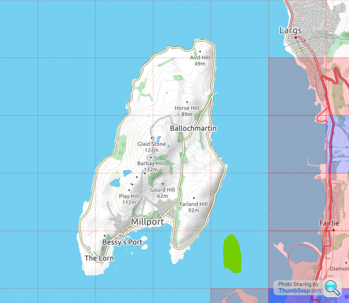
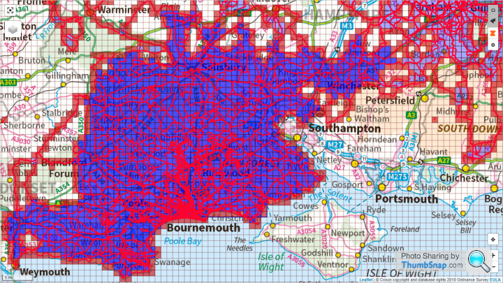
While I'm here, I might as well update my recent VeloViewer tiling outings.
Monday 19th October - 66 miles for three tiles. One of them that Poole Harbour one I missed on a visit to Brownsea Island. The stats from that were Max Square = 22x22 (no change), and Max Cluster = 1215 (up by 14 tiles). https://www.strava.com/activities/4217067952
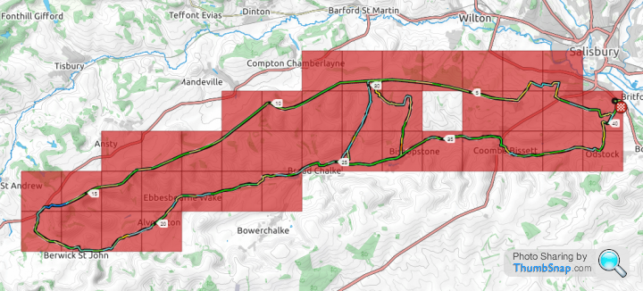
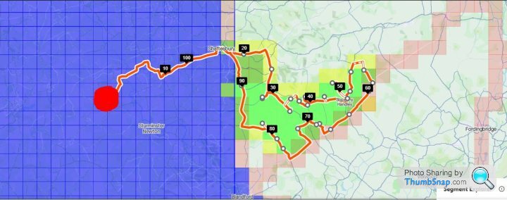
Tuesday 20th October - 40 miles for fourteen tiles. First outing on my Cannondale Backroads in ages, up onto the Old Shaftesbury Drove west out of Salisbury, and back along the Chalke Valley. Mostly a night ride too. Love those! Stats there were Max Square = 24x24 (up by 2), and Max Cluster = 1260 (up by 45 tiles). https://www.strava.com/activities/4221896295
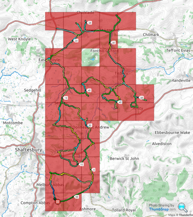
Thursday 22nd October - 56 miles for thirty four tiles. Glad I took the 'Dale again, because the roads were absolutely terrible. Muddier than most bridleways in some places. This one was an attempt to "square off" the north west corner of my Max Square, but one tile 'escaped' because I wasn't properly concentrating on my map reading and when I realised I'd missed it it really was too late to go back for it (front light down to less than half an hour of battery power). Stats for this one were Max Square = 26x26 (up by 2) and Max Cluster = 1292 (up by 32 tiles). https://www.strava.com/activities/4230788411
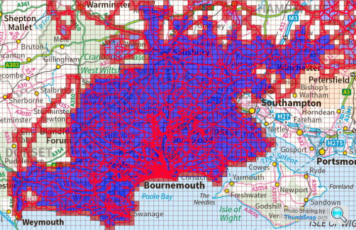
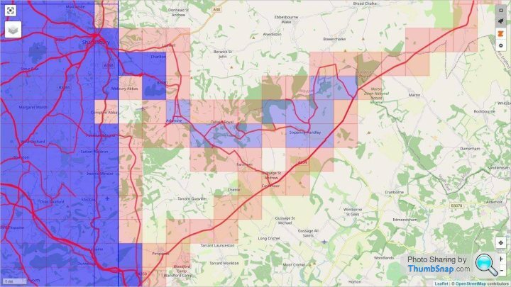
All this has left me with a few single tiles and small groups that I've missed here and there, but they are a mix of road and byway/bridleway, and they are quite widely spaced. There are six tiles south of the "Porton Down Impossibles" preventing expansion to a 29x29 Max Square, for example. To do them in one ride, even if I started riding within one of those tiles, would mean a 73 mile trip...
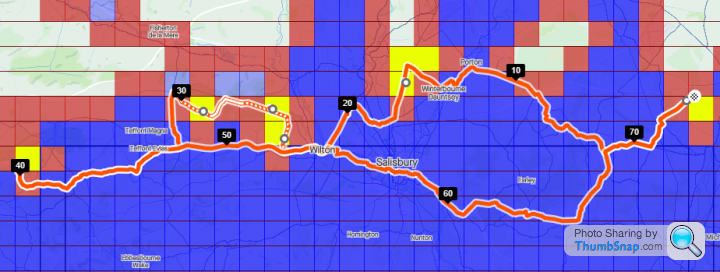
...the four Porton Down tiles are the ones near the 10 mile marker on the map. I'd love to do this as a single ride, but the realist in me knows it'd be best to break them into three groups, and combine them with other tiles to the north and west as a more efficient use of time.
I'm quite surprised at the speed of Max Square expansion over the last few weeks. It stood at 18x18 from at least late May to 03rd September. Then it stood at 19x19 for a month The jump to 22x22 felt like significant progress when it came on 05th October, but it's jumped quite noticeably this week, from 22x22 on Monday to 26x26 on Thursday. Now, though, things will slow down. I'm nearly at the point where those "Porton Down Impossibles" will come into play, and to get beyond 29x29 I'll have to focus my attention further east or further west (or both! )
)
The big picture map looks a lot tidier now, though, than it did a few weeks ago...
Monday 19th October - 66 miles for three tiles. One of them that Poole Harbour one I missed on a visit to Brownsea Island. The stats from that were Max Square = 22x22 (no change), and Max Cluster = 1215 (up by 14 tiles). https://www.strava.com/activities/4217067952
Tuesday 20th October - 40 miles for fourteen tiles. First outing on my Cannondale Backroads in ages, up onto the Old Shaftesbury Drove west out of Salisbury, and back along the Chalke Valley. Mostly a night ride too. Love those! Stats there were Max Square = 24x24 (up by 2), and Max Cluster = 1260 (up by 45 tiles). https://www.strava.com/activities/4221896295
Thursday 22nd October - 56 miles for thirty four tiles. Glad I took the 'Dale again, because the roads were absolutely terrible. Muddier than most bridleways in some places. This one was an attempt to "square off" the north west corner of my Max Square, but one tile 'escaped' because I wasn't properly concentrating on my map reading and when I realised I'd missed it it really was too late to go back for it (front light down to less than half an hour of battery power). Stats for this one were Max Square = 26x26 (up by 2) and Max Cluster = 1292 (up by 32 tiles). https://www.strava.com/activities/4230788411
All this has left me with a few single tiles and small groups that I've missed here and there, but they are a mix of road and byway/bridleway, and they are quite widely spaced. There are six tiles south of the "Porton Down Impossibles" preventing expansion to a 29x29 Max Square, for example. To do them in one ride, even if I started riding within one of those tiles, would mean a 73 mile trip...
...the four Porton Down tiles are the ones near the 10 mile marker on the map. I'd love to do this as a single ride, but the realist in me knows it'd be best to break them into three groups, and combine them with other tiles to the north and west as a more efficient use of time.
I'm quite surprised at the speed of Max Square expansion over the last few weeks. It stood at 18x18 from at least late May to 03rd September. Then it stood at 19x19 for a month The jump to 22x22 felt like significant progress when it came on 05th October, but it's jumped quite noticeably this week, from 22x22 on Monday to 26x26 on Thursday. Now, though, things will slow down. I'm nearly at the point where those "Porton Down Impossibles" will come into play, and to get beyond 29x29 I'll have to focus my attention further east or further west (or both!
)The big picture map looks a lot tidier now, though, than it did a few weeks ago...
yellowjack said:
loudlashadjuster said:
Would it be cricket to keep your Garmin on on the ferry to Millport to try and increase your max cluster when you cycle round Cumbrae?
I've considered doing that down on the south coast. Could have saved myself being shouted at in the Port Of Poole if I'd just started my Garmin on the Quayside a week before when I visited Brownsea Island and missed claiming a tile by a matter of yards. The ferry ride definitely would have passed through the tile I 'needed'. Same with the Isle Of Wight if/when I go across there. Recording the crossing would allow me to join up any cluster I get on the island with my mainland cluster, provided I choose the right ferry crossing. It's probably not in the spirit of "tiling", but for the purposes of neatly colouring in my digital map, it appeals to the OCD in me...
The most ambitious route I have in that respect is this, however, which might involve a mild bit of wading off Chesil beach. Kind of crucial for getting my max cluster onto Portland...
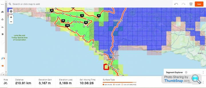
No, I don't necessarily plan on doing that route! I just quite enjoy planning these things, as well as riding them.
Edited by Solocle on Friday 23 October 18:27
Re. "Cricket" its your call. nearly all All mine have been from my house. exceptions are hills where there are paths but officially not allowed to cycle - in which case i walked into the square i never drove there. At 22x22 its tempting to drive to the start then pedal - but not done it yet: Feels like cheating, but not sure.
Getting a tile whilst not walking or riding? Imo makes it all worthless. Each to their own tho. The only important thing is that you enjoy what you do.
Getting a tile whilst not walking or riding? Imo makes it all worthless. Each to their own tho. The only important thing is that you enjoy what you do.
Solocle said:
The most ambitious route I have in that respect is this, however, which might involve a mild bit of wading off Chesil beach. Kind of crucial for getting my max cluster onto Portland...
No, I don't necessarily plan on doing that route! I just quite enjoy planning these things, as well as riding them.
No, I don't necessarily plan on doing that route! I just quite enjoy planning these things, as well as riding them.
I've "wasted" so much riding time poring over maps! But yes, planning is lots of fun, especially as an alternative to watching the rain running down the kitchen window.
And yes, I've noticed those tiles along Chesil Beach too...
Frustratingly, if I was still in the army I could have just gone down to Chickerell Camp/Wyke Regis, signed out a kayak from the Bridging Hard sports store, and cracked the whole of Chesil Beach and I'd have got paid for the privilege. Now I think I'll have to drive down there and take a walk or run along the shingle (hideous, and used to be a punishment on bridging camps) to crack a lot of Chesil Beach. It remains to be seen how far into the old Portland Naval Base it's possible to get nowadays. Again, back when I was in uniform I could probably have just flashed my ID card and gone for a run around the base. I played hockey there against a RN team once. If only Strava and wearable GPS tech had been available back then, I could have recorded a GPS trace of me running around an AstroTurf pitch for 80 minutes!
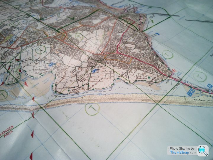
When I first marked up my maps I plotted a few lines and then measured the others from a start point. Then I had to go back and start again because the lines aren't parallel The tiles are narrower at the top than the bottom in the northern hemisphere, tapering to almost nothing at the North Pole. Now I plot a number of points where the lines intersect an identifiable map feature, then "join the dots". When I'm out on a ride I use the "Save Location" feature on my Garmin watch, which gives me a ten figure grid reference. So far this has been sufficient to ensure I've gotten far enough in to tiles to claim them. But it only works if the GPS is accurate AND I've plotted the lines correctly.
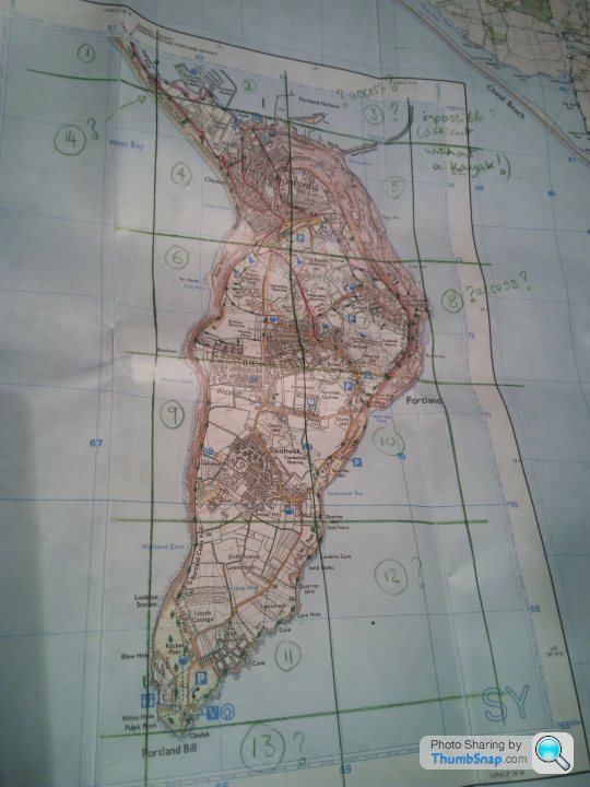
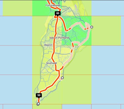
In terms of Max Square, Portland is no use to man nor beast. No point in tiling south of Charmouth/Lyme Regis really because of the shape of the coastline. But I will still want to colour in Portland and the Weymouth~Dorchester~Charmouth triangle to keep things looking neat and contribute to my Max Cluster...
Edited by yellowjack on Sunday 25th October 00:58
yellowjack said:
I've "wasted" so much riding time poring over maps! But yes, planning is lots of fun, especially as an alternative to watching the rain running down the kitchen window.
And yes, I've noticed those tiles along Chesil Beach too...
Frustratingly, if I was still in the army I could have just gone down to Chickerell Camp/Wyke Regis, signed out a kayak from the Bridging Hard sports store, and cracked the whole of Chesil Beach and I'd have got paid for the privilege. Now I think I'll have to drive down there and take a walk or run along the shingle (hideous, and used to be a punishment on bridging camps) to crack a lot of Chesil Beach. It remains to be seen how far into the old Portland Naval Base it's possible to get nowadays. Again, back when I was in uniform I could probably have just flashed my ID card and gone for a run around the base. I played hockey there against a RN team once. If only Strava and wearable GPS tech had been available back then, I could have recorded a GPS trace of me running around an AstroTurf pitch for 80 minutes!
When I first marked up my maps I plotted a few lines and then measured the others from a start point. Then I had to go back and start again because the lines aren't parallel The tiles are narrower at the top than the bottom in the northern hemisphere, tapering to almost nothing at the North Pole. Now I plot a number of points where the lines intersect an identifiable map feature, then "join the dots". When I'm out on a ride I use the "Save Location" feature on my Garmin watch, which gives me a ten figure grid reference. So far this has been sufficient to ensure I've gotten far enough in to tiles to claim them. But it only works if the GPS is accurate AND I've plotted the lines correctly.
In terms of Max Square, Portland is no use to man nor beast. No point in tiling south of Charmouth/Lyme Regis really because of the shape of the coastline. But I will still want to colour in Portland and the Weymouth~Dorchester~Charmouth triangle to keep things looking neat and contribute to my Max Cluster...
Edited by yellowjack on Sunday 25th October 00:58
Wikipedia said:
Little Beach can be reached via a pathway veering off the official coastal path of the East Weares area. A similar pathway further north links to the Salt Pans, and the remains of the Folly Pier Waterworks. The beach can also be reached via the coastline edge as well.
The next one for me will probably be something like this:
That caps off the NE corner of Dorset, then I'll have the A354 and A338 rides as boundaries to tile between for the SE. The only few tiles that escape that threshold are Hengistbury and Highcliffe-on-sea.
Some Gump said:
Re. "Cricket" its your call. nearly all All mine have been from my house. exceptions are hills where there are paths but officially not allowed to cycle - in which case i walked into the square i never drove there. At 22x22 its tempting to drive to the start then pedal - but not done it yet: Feels like cheating, but not sure.
.
Almost all of my tiles to date have been aquired on rides to/from my house, but in the last week, due to a combination of fading light available when I get home from work, and very few tiles I need being accesible in a ride less then two hours long, I've kept a bike in my car and have started to do some rides in new territory close to my workplace, which is an hour's drive from where I live. .
This has opened up a huge range of options for me, and I'm now really enjoying poring over maps working out the most efficient routes I can do to get the maximum new tiles.
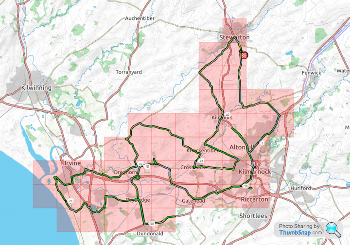
Comacchio said:
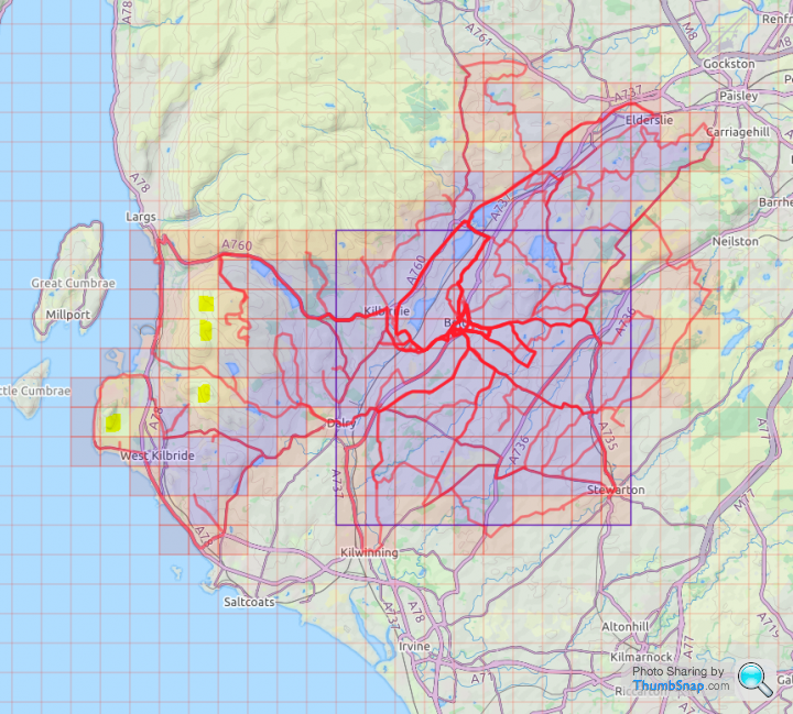
Never got out on Saturday but did tonight. Knee feels a little better after my bike fit last night, still a little bit of pain but tonight's ride wasn't long enough to get a proper idea of if the fit has fixed it. Tonight's ride was targeted at the 2 tiles at the north west of my cluster that don't have roads anywhere near them. The cycle up in the dark was fun, the hike across into the water logged moor wasn't fun at all. Walking through 6 inches of boggy ground, falling into hidden rivers... glad I ticked them off!

VV score: 85.113 (Up from 85.034)
294 tiles (Up from 292 tiles), average of 2.907 (up from 2.906) mi per tile
Max square: 10x10 (No change)
Max cluster: 156 (Up from 147)
Eddington Ride: 22 (No change)
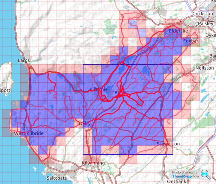
Map as it stands:
Next ride out I'll park up at Stewarton and ride down to Kilmarnock to block off the cluster then start to fill in the rest of the missing tiles before we move on to the new house.
Edited by Comacchio on Tuesday 27th October 20:59
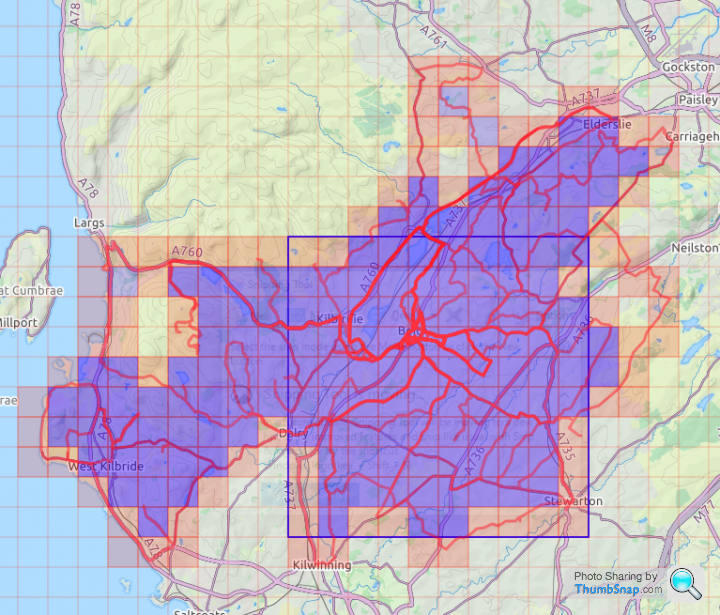
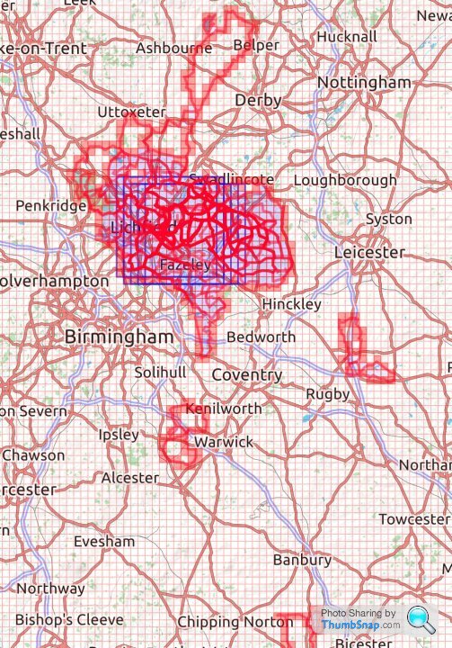
Well that was a tough day out. Crosswinds, headwinds...everything but tailwinds!! Speed sensor is faulty, had to strip out some of the data from my .fit file in order to upload to Strava without it claiming I done 90 odd miles when it was actually about 45.
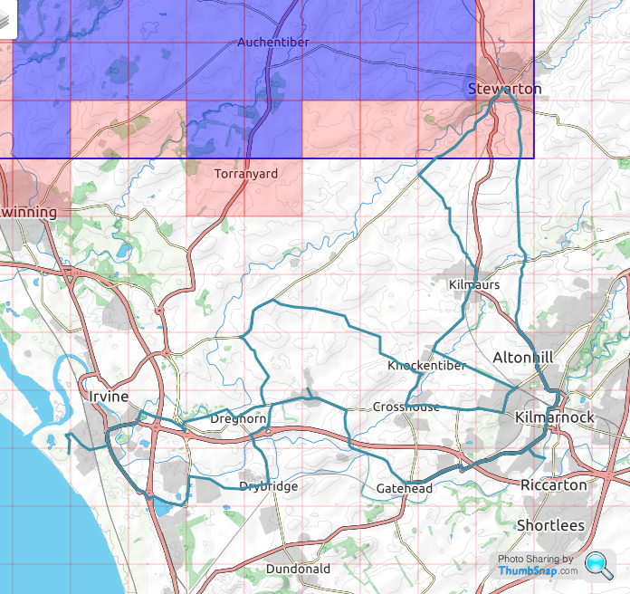
Ride:
VV score: 85.332 (Up from 85.113)
339 tiles (Up from 294 tiles), average of 2.652 (down from 2.907) mi per tile
Max square: 10x10 (No change)
Max cluster: 157 (Up from 156)
Eddington Ride: 23 (Up from 22)
Map as of this afternoon:

Time for a few beers and a sleep!
Ride:
VV score: 85.332 (Up from 85.113)
339 tiles (Up from 294 tiles), average of 2.652 (down from 2.907) mi per tile
Max square: 10x10 (No change)
Max cluster: 157 (Up from 156)
Eddington Ride: 23 (Up from 22)
Map as of this afternoon:
Time for a few beers and a sleep!
My October stats:
702 tiles (was 597)
Max square 14x14 (was 13x13)
Max cluster 384 (was 316)
Veloviewer score: 92.458 (can’t remember what this was a month ago, but it’s steadily improving).
I’ve just started to build a new cluster by doing rides after work in the Rugby area, with the eventual aim of joining up with my main cluster. This will keep me out cycling during the winter months as I’ve got an hour’s drive home from work, and there isn’t much daylight left when I get home, but I’m now able to do a 90 minute ride before it gets dark if I go straight from work.
Well done to all those who have continued riding recently, despite some quite hostile weather in parts of the UK. 
Not a great deal of riding for me recently. Mostly curtailed by the weather, and my wife having time off on days when the weather was kinder. The rest of this week looks much better for cycling (if a little colder). So I'm hoping to go out and do some "tidying up" of a few "loose" tiles in my 'old' Cluster. Which could well open the floodgates, so to speak, and finally join both of my Clusters together...

...this screen grab doesn't actually show the clusters, but suffice to say that those single blank tiles and small groups, especially those south of Basingstoke, are acting as "stoppers" blocking the spread of my Max Cluster right back into the eastern side of that map.
That would leave me with an obvious focus of filling in the large empty space either side of the A34.
My current Max Square is 26x26. The four 'Impossible Tiles' under the 'G' in 'Grateley' are going to halt progress on that Square when I get to 29x29, so expansion to the east makes sense to me. I've already covered the bulk of the ground out that way, and it shouldn't require too much "off roading" to nab most tiles over there. Just the extra travel time to the start of the tiling to annoy me really.
The current VeloViewer stats (as at the end of my last ride on 28th October 2020)...
VeloViewer Score = 98.619
Explorer Score = 3628
Max Square = 26x26
Max Cluster = 1370
Not a great deal of riding for me recently. Mostly curtailed by the weather, and my wife having time off on days when the weather was kinder. The rest of this week looks much better for cycling (if a little colder). So I'm hoping to go out and do some "tidying up" of a few "loose" tiles in my 'old' Cluster. Which could well open the floodgates, so to speak, and finally join both of my Clusters together...
...this screen grab doesn't actually show the clusters, but suffice to say that those single blank tiles and small groups, especially those south of Basingstoke, are acting as "stoppers" blocking the spread of my Max Cluster right back into the eastern side of that map.
That would leave me with an obvious focus of filling in the large empty space either side of the A34.
My current Max Square is 26x26. The four 'Impossible Tiles' under the 'G' in 'Grateley' are going to halt progress on that Square when I get to 29x29, so expansion to the east makes sense to me. I've already covered the bulk of the ground out that way, and it shouldn't require too much "off roading" to nab most tiles over there. Just the extra travel time to the start of the tiling to annoy me really.
The current VeloViewer stats (as at the end of my last ride on 28th October 2020)...
VeloViewer Score = 98.619
Explorer Score = 3628
Max Square = 26x26
Max Cluster = 1370
Away from tiling, another good use of VV is checking out hills. I watched the pros going up the Angliru in the Vuelta yesterday, and my chat group was alive with "Could any of us do that?" Someone mentioned 3 local climbs that are tough, Steyning Bostal, Bexley Hill and Bignor. So I did a quick comparison on VV -
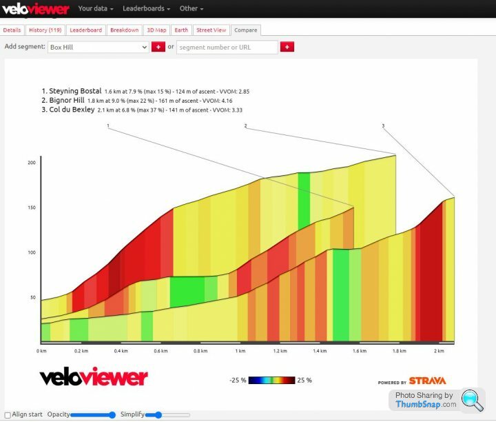
I don't think the text above the graphs is accurate, I think Steyning gets to over 17% in places, especially as that's what the road sign says. And Bexley doesn't get to 37% either.
But then I added the Angliru...
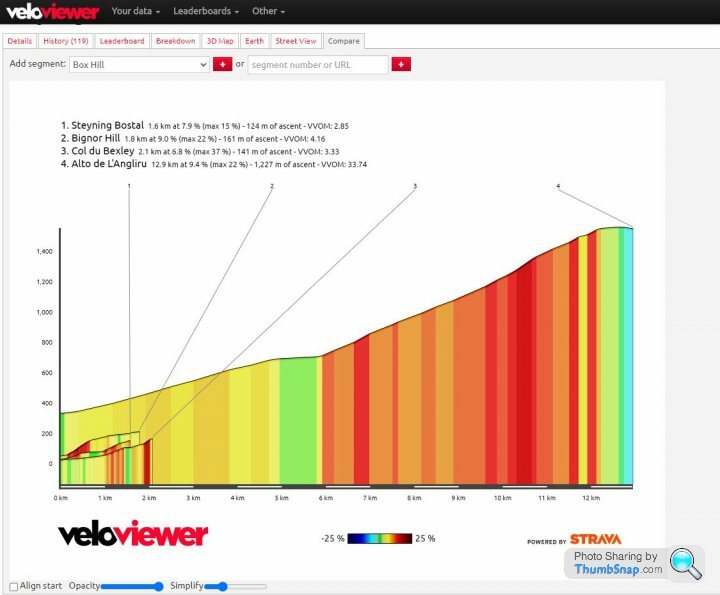
I don't think the text above the graphs is accurate, I think Steyning gets to over 17% in places, especially as that's what the road sign says. And Bexley doesn't get to 37% either.
But then I added the Angliru...
Daveyraveygravey said:
Away from tiling, another good use of VV is checking out hills. I watched the pros going up the Angliru in the Vuelta yesterday, and my chat group was alive with "Could any of us do that?" Someone mentioned 3 local climbs that are tough, Steyning Bostal, Bexley Hill and Bignor. So I did a quick comparison on VV -
I don't think the text above the graphs is accurate, I think Steyning gets to over 17% in places, especially as that's what the road sign says. And Bexley doesn't get to 37% either.
But then I added the Angliru...
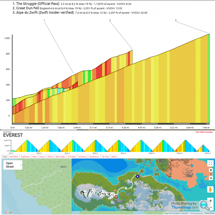
I hadn't seen that compare function before... here are the three biggest climbs I've ever done:I don't think the text above the graphs is accurate, I think Steyning gets to over 17% in places, especially as that's what the road sign says. And Bexley doesn't get to 37% either.
But then I added the Angliru...
Gassing Station | Pedal Powered | Top of Page | What's New | My Stuff