Veloviewer. Who is using it, and what do you get from it?
Discussion


ukbabz said:
Just plotted another ride for the weekend, should take in 14 new tiles and increase mine to a 15x15.
I do find it tricky to work out where to go next! some longer ride outs to get much further than that but is interesting trying to plan it all
I do find it tricky to work out where to go next! some longer ride outs to get much further than that but is interesting trying to plan it all

This is part of the appeal. Yesterday I went off in search of 8 tiles along the Piddle Valley (Oi! No sniggering at the back!) between Bere Regis, Bovington and Wareham. I got sidetracked on a "draw a big willy" segment a Strava buddy created in Lytchett Matravers and didn't claim a single new tile.
I've started using Strava route creator now, just to see how far I need to ride to claim new tiles out west. Rides of 70+ miles are only returning a small handful of tiles now. And many of those tiles are on OS map sheets I don't have at home, too. So I might have to dig out my old Edge500 for a while and follow set routes (not a favourite pastime of mine, I prefer to "ride casual" and explore a bit). The "ride time" estimates end up way off though, usually because I take my road bike onto gravel tracks and have to slow down to nurse the tyres over gravel to avoid flats. So I end up coming back having ridden for a longer time than planned, but I've covered fewer miles than intended. It's a wee bit frustrating some days, but on the whole the views from some of the bridleways I've ended up on have more than made up for the shorter distances covered.
colin_p said:
I've always fancied getting into trig-pointing via bicycle.
It would provide proper goals and excuses for all you tile hunters! Grab some tiles and bag some trigs at the same time.
Nooooooooo! It would provide proper goals and excuses for all you tile hunters! Grab some tiles and bag some trigs at the same time.
I shouldn't ask really, as it'd just be something else to obsess about. What exactly is "trig-pointing"? Is it something that requires some sort of documentary evidence (brass-rubbing or photograph of the ID plate on the trig point) or is it GPS based? Because I've found some pretty obscure trig-points when I've been out riding. The sort that are hidden away in heathland or woodland in places you might not expect to find one.
yellowjack said:
Welcome to the madhouse! With a small Max Square, expansion should be quick. When it gets bigger you either have to ride a lot further for fewer tiles, or end up driving out to riding spots. Which side of the Sandbanks Ferry are you? I'm on the Bournemouth side, and although they won't help my Max Square much I want to "colour in" Purbeck as much as possible. I'm going to have to hit the gravel bike, or my MTB soon, because I'm starting to hit tiles where the bridleways aren't very forgiving on my road bike.
I'm just north of the ferry in Poole. I get so bored of the route up through Broadstone in order to get to the nice quiet routes north of Wimborne so I see the ferry as essential for easy access to the countryside to the south.There are loads of nice tracks across the Purbecks and the views are stunning. If it ever reopens, the garden at the Scott Arms is great for lunch and views of Corfe. Some of my riding is done with a small handful of OAPs on ebikes and their idea of a good ride is 30 - 40 miles spread over 6 hours with at least one coffee stop and two pub stops for refreshments then lunch. It's a nice day out and quite relaxing for me being 30 years younger although I can't see it happening at all this year.

No point going out for a ride to pick up one or two tiles now, is there!? Well, my last ride was two tiles... the good news is that I can much more easily expand NW.
2129/2205 tiles (+76)
Average of 2.938/2.882 mi per tile (-0.056 mi)
Max square 13x13 View map (-)
Max Cluster: 203/275 (+72)
yellowjack said:
colin_p said:
I've always fancied getting into trig-pointing via bicycle.
It would provide proper goals and excuses for all you tile hunters! Grab some tiles and bag some trigs at the same time.
Nooooooooo! It would provide proper goals and excuses for all you tile hunters! Grab some tiles and bag some trigs at the same time.
I shouldn't ask really, as it'd just be something else to obsess about. What exactly is "trig-pointing"? Is it something that requires some sort of documentary evidence (brass-rubbing or photograph of the ID plate on the trig point) or is it GPS based? Because I've found some pretty obscure trig-points when I've been out riding. The sort that are hidden away in heathland or woodland in places you might not expect to find one.
http://trigpointing.uk/
WARNING! .... a very deep rabbit hole maybe found
 ...and there is an app for live bagging!
AndrewT1275 said:
I'm just north of the ferry in Poole. I get so bored of the route up through Broadstone in order to get to the nice quiet routes north of Wimborne so I see the ferry as essential for easy access to the countryside to the south.
There are loads of nice tracks across the Purbecks and the views are stunning. If it ever reopens, the garden at the Scott Arms is great for lunch and views of Corfe. Some of my riding is done with a small handful of OAPs on ebikes and their idea of a good ride is 30 - 40 miles spread over 6 hours with at least one coffee stop and two pub stops for refreshments then lunch. It's a nice day out and quite relaxing for me being 30 years younger although I can't see it happening at all this year.
I was heading to Wareham Forest today to ride a "Gravel Smash" 12 mile segment. I'm getting bored with my route through Bournemouth to Wimborne and Lytchett Minster too. So I thought I'd change it up a little and just follow my (GPS) compass. Got as far as Bournemouth Uni before road closures (resurfacing works) sent me off into the unknown (to me, at least). I ended up on a cycle path past Tower Park, heading to Upton. And that was where my planned route got punted into touch and I headed north to Corfe Mullen and Sturminster Marshall. A spell on the A31 before Mapperton and a detour on a bridle path for miles and miles to Thornicombe, before coming back through Wimborne, Bear Cross and Kinson. And the map I'd taken? The top edge finished at Upton so I was "riding blind" in places i'd never ridden before after that. There are loads of nice tracks across the Purbecks and the views are stunning. If it ever reopens, the garden at the Scott Arms is great for lunch and views of Corfe. Some of my riding is done with a small handful of OAPs on ebikes and their idea of a good ride is 30 - 40 miles spread over 6 hours with at least one coffee stop and two pub stops for refreshments then lunch. It's a nice day out and quite relaxing for me being 30 years younger although I can't see it happening at all this year.
Managed 11 new tiles, mind, through shear blind luck!
yellowjack said:
I was heading to Wareham Forest today to ride a "Gravel Smash" 12 mile segment. I'm getting bored with my route through Bournemouth to Wimborne and Lytchett Minster too. So I thought I'd change it up a little and just follow my (GPS) compass. Got as far as Bournemouth Uni before road closures (resurfacing works) sent me off into the unknown (to me, at least). I ended up on a cycle path past Tower Park, heading to Upton. And that was where my planned route got punted into touch and I headed north to Corfe Mullen and Sturminster Marshall. A spell on the A31 before Mapperton and a detour on a bridle path for miles and miles to Thornicombe, before coming back through Wimborne, Bear Cross and Kinson. And the map I'd taken? The top edge finished at Upton so I was "riding blind" in places i'd never ridden before after that.
Managed 11 new tiles, mind, through shear blind luck!
Nice effort. I managed two new tiles today. I had to be a bit creative around RAF Welford and ended up riding half way up a footpath on my carbon road bike to snag a segment. Also misjudged the distance and thought it was about 35km and was closer to 70km. Should be a good setup for next ride to get up to 15x15 or 16x16 as I close off a few gaps.Managed 11 new tiles, mind, through shear blind luck!
Solocle said:
No point going out for a ride to pick up one or two tiles now, is there!? Well, my last ride was two tiles... the good news is that I can much more easily expand NW.
2129/2205 tiles (+76)
Average of 2.938/2.882 mi per tile (-0.056 mi)
Max square 13x13 View map (-)
Max Cluster: 203/275 (+72)
It looks like you have vv and strava route builder together somehow? Please share your secret

Some Gump said:
How have you one that???
It looks like you have vv and strava route builder together somehow? Please share your secret
https://blog.veloviewer.com/veloviewer-chrome-exte...It looks like you have vv and strava route builder together somehow? Please share your secret
Top left of the Strava Route Builder - click the "cog" icon and switch on Veloviewer Explorer. That adds the tile outlines, and shows your completed tiles, Max Square, and Max Cluster. I think it imports all the colours and settings direct from Veloviewer, so set them up there. Oh, and you need to have downloaded the Chrome Extension for veloviewer/strava too.
I believe you do need to minimise your privacy settings for sharing the info between the two sites though. Ben (Lowe - 'Mr VeloViewer') has made assurances about privacy, but to use the feature on Route Builder you do have to turn some of the privacy settings down. I forget where on the veloviewer pages these settings are, but I'm sure I found them by reading through the blogs on VV.
Sorry if some of my terminology isn't spot on - I'm a curmudgeonly middle-aged cyclist, not a tech boffin, but if I can manage it I'm sure most people can...

Devastating loss of 40 tiles-worth of data on Friday!
My Garmin Forerunner 910 XT watch seems to have failed to write the data correctly and it is corrupted. No amount of messing and fussing with help forums or online repair tools helps, due to the ANT+ upload only "feature" of the watch. So I can't bust the corrupted file out of it's watch-bound "jail" to even try to repair it.
12 hours out on the bike, over 10 hours moving, and 125.17 miles ridden. And yet all the tiles I "earned" during the ride are unclaimed. Damn it!
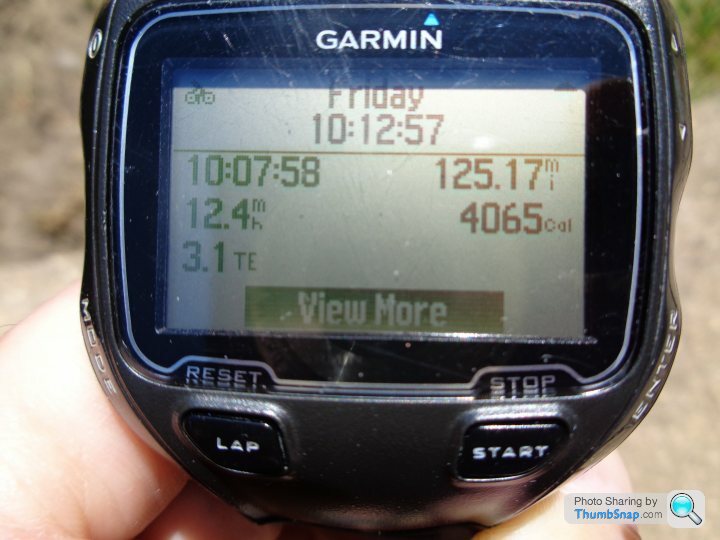
Anyone know what that "3.1 TE" field is on the watch's activity history screen? Not a data field I recall seeing before, so maybe something to do with why the activity won't upload?
Loads of tiles in the New Forest around Beaulieu Road Station, up into Marchwood, over to Redbridge on the Southampton side, up as far as Ashfield, taking in the Test Way, finishing near Nomansland via West Wellow, etc. All ridden from home, hence the large distance covered. Looks like I'll now have to ride those tiles again, but I think I'll take the bike to the tiles in my car next time, and park somewhere central to nab them all again, as I don't really have time to go re-riding the whole route from home next time out...
This ride was supposed to lay the foundations for a big increase in my Max Square over the next couple of weeks. First world problems and all, but it feels like a big personal setback for me. After this setback, the watch recorded two activities on Saturday, both walks (but recorded as runs to the watch) and uploaded them as normal. Typically it's not a short 'throwaway' walk or jog that the watch decides to bugger up, but a pretty big ride with lots of achievements worth uploading. Grrr!
My Garmin Forerunner 910 XT watch seems to have failed to write the data correctly and it is corrupted. No amount of messing and fussing with help forums or online repair tools helps, due to the ANT+ upload only "feature" of the watch. So I can't bust the corrupted file out of it's watch-bound "jail" to even try to repair it.
12 hours out on the bike, over 10 hours moving, and 125.17 miles ridden. And yet all the tiles I "earned" during the ride are unclaimed. Damn it!
Anyone know what that "3.1 TE" field is on the watch's activity history screen? Not a data field I recall seeing before, so maybe something to do with why the activity won't upload?
Loads of tiles in the New Forest around Beaulieu Road Station, up into Marchwood, over to Redbridge on the Southampton side, up as far as Ashfield, taking in the Test Way, finishing near Nomansland via West Wellow, etc. All ridden from home, hence the large distance covered. Looks like I'll now have to ride those tiles again, but I think I'll take the bike to the tiles in my car next time, and park somewhere central to nab them all again, as I don't really have time to go re-riding the whole route from home next time out...
This ride was supposed to lay the foundations for a big increase in my Max Square over the next couple of weeks. First world problems and all, but it feels like a big personal setback for me. After this setback, the watch recorded two activities on Saturday, both walks (but recorded as runs to the watch) and uploaded them as normal. Typically it's not a short 'throwaway' walk or jog that the watch decides to bugger up, but a pretty big ride with lots of achievements worth uploading. Grrr!
yellowjack said:
Devastating loss of 40 tiles-worth of data on Friday!
My Garmin Forerunner 910 XT watch seems to have failed to write the data correctly and it is corrupted. No amount of messing and fussing with help forums or online repair tools helps, due to the ANT+ upload only "feature" of the watch. So I can't bust the corrupted file out of it's watch-bound "jail" to even try to repair it.
12 hours out on the bike, over 10 hours moving, and 125.17 miles ridden. And yet all the tiles I "earned" during the ride are unclaimed. Damn it!
Anyone know what that "3.1 TE" field is on the watch's activity history screen? Not a data field I recall seeing before, so maybe something to do with why the activity won't upload?
Loads of tiles in the New Forest around Beaulieu Road Station, up into Marchwood, over to Redbridge on the Southampton side, up as far as Ashfield, taking in the Test Way, finishing near Nomansland via West Wellow, etc. All ridden from home, hence the large distance covered. Looks like I'll now have to ride those tiles again, but I think I'll take the bike to the tiles in my car next time, and park somewhere central to nab them all again, as I don't really have time to go re-riding the whole route from home next time out...
This ride was supposed to lay the foundations for a big increase in my Max Square over the next couple of weeks. First world problems and all, but it feels like a big personal setback for me. After this setback, the watch recorded two activities on Saturday, both walks (but recorded as runs to the watch) and uploaded them as normal. Typically it's not a short 'throwaway' walk or jog that the watch decides to bugger up, but a pretty big ride with lots of achievements worth uploading. Grrr!
'Devastating' must have a new definition these days, that s not My Garmin Forerunner 910 XT watch seems to have failed to write the data correctly and it is corrupted. No amount of messing and fussing with help forums or online repair tools helps, due to the ANT+ upload only "feature" of the watch. So I can't bust the corrupted file out of it's watch-bound "jail" to even try to repair it.
12 hours out on the bike, over 10 hours moving, and 125.17 miles ridden. And yet all the tiles I "earned" during the ride are unclaimed. Damn it!
Anyone know what that "3.1 TE" field is on the watch's activity history screen? Not a data field I recall seeing before, so maybe something to do with why the activity won't upload?
Loads of tiles in the New Forest around Beaulieu Road Station, up into Marchwood, over to Redbridge on the Southampton side, up as far as Ashfield, taking in the Test Way, finishing near Nomansland via West Wellow, etc. All ridden from home, hence the large distance covered. Looks like I'll now have to ride those tiles again, but I think I'll take the bike to the tiles in my car next time, and park somewhere central to nab them all again, as I don't really have time to go re-riding the whole route from home next time out...
This ride was supposed to lay the foundations for a big increase in my Max Square over the next couple of weeks. First world problems and all, but it feels like a big personal setback for me. After this setback, the watch recorded two activities on Saturday, both walks (but recorded as runs to the watch) and uploaded them as normal. Typically it's not a short 'throwaway' walk or jog that the watch decides to bugger up, but a pretty big ride with lots of achievements worth uploading. Grrr!
TCX said:
'Devastating' must have a new definition these days, that s not
Yes. Quite. I'm clearly "hamming it up" for an online audience, hoping that someone, somewhere, will know of a solution to this issue so that I can "get back my lost tiles".Alternatively, I have a different definition of "devastating" to you? The problem has certainly "devastated" my mood this weekend...
yellowjack said:
TCX said:
'Devastating' must have a new definition these days, that s not
Yes. Quite. I'm clearly "hamming it up" for an online audience, hoping that someone, somewhere, will know of a solution to this issue so that I can "get back my lost tiles".Alternatively, I have a different definition of "devastating" to you? The problem has certainly "devastated" my mood this weekend...
https://gotoes.org/strava/Add_Timestamps_To_GPX.ph...
Solocle said:
Personally, having ridden the route, use gotoes to add timestamps based on an appropriate average speed, set the activity to followers-only/private so that you don't get some unwarranted KOMs, and voila! Veloviewer will tick off those tiles.
https://gotoes.org/strava/Add_Timestamps_To_GPX.ph...
For clarity, I have no file available to add time stamps to. Can I use that tool to add time stamps to a GPS "planned" route to make it look like an activity?https://gotoes.org/strava/Add_Timestamps_To_GPX.ph...
It was a complex route, to be honest. lots of off-road gravel tracks around forest areas, all navigated off an OS map. There was an outline plan when I started, but it changed/evolved many times when faced with the ground compared with the map. So I'm not even sure I could genuinely trace my exact route from memory now.
Ill take a better look at your link when I have more time, but I'm not great with computers really, nor with tech generally. It sounds pathetic but I'd probably need someone to sit beside me and "hold my hand" through a process like that. And they'd probably need earplugs for the shouting and swearing too!
Edit to add
OK. Gave it a try. Made a route on Strava route builder as best as I could remember it. That worked, so I used the tool you linked to. That worked too. So I uploaded the "faked" ride to Strava (kept private for my eyes only, and marked as fake in my activity notes). That worked as well, and now those "missing" tiles have been claimed on VeloViewer.
Got to say, it feels like a bit of a "hollow victory" if I'm honest. Keeping my average speed realistic to my ride, and using the tool to "take elevation into account" resulted in only two PRs. Probably unrepeatable by me, but not greatly unrealistic in terms of overall leaderboards. Certainly no flag-worthy KOMs or trophies falsely claimed, which is good. Probably actually robbed myself of a few high placings on some of the more benign forest gravel tracks.
Anyway. It has given me the tiles I'd lost, so thanks for that. I can always ride those tiles again, too, to get a more honest result if I want to. But it has "set the record straight" for now.
Veloviewer Score up from 98.118 to 98.135 (possibly those two new PRs, but I think it would have gone up by more with the "real" ride data)
42 new tiles visited, up from 2639 to 2681 (I think this has claimed 2 more tiles than I intended)
Max Cluster remains at 636
Max Square up from 14x14 to 18x18
If nothing else, this little 'Lost Data' saga has demonstrated how bad my obsessive behaviour still is. I though I was getting better, but clearly not. Ho-Hum...
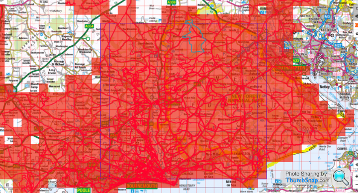
The newly claimed tiles are all in the eastern section of the New Forest, and up from Totton, coming back via Redlynch and Nomansland (what a cheeky climb it was coming out of there, too!) Still a few to explore on the shore of The Solent, if indeed they are accessible. But industry and dockyards all with security and limited access may put a stop to riding (or even walking) in some of those tiles...
Edited by yellowjack on Monday 18th May 14:28
yellowjack said:
For clarity, I have no file available to add time stamps to. Can I use that tool to add time stamps to a GPS "planned" route to make it look like an activity?
It was a complex route, to be honest. lots of off-road gravel tracks around forest areas, all navigated off an OS map. There was an outline plan when I started, but it changed/evolved many times when faced with the ground compared with the map. So I'm not even sure I could genuinely trace my exact route from memory now.
Ill take a better look at your link when I have more time, but I'm not great with computers really, nor with tech generally. It sounds pathetic but I'd probably need someone to sit beside me and "hold my hand" through a process like that. And they'd probably need earplugs for the shouting and swearing too!
Yeah, you feed it a route, it'll produce an activity! So, the strava route tool, with the veloviewer extension, as long as you know which tiles you nabbed, will be fine.It was a complex route, to be honest. lots of off-road gravel tracks around forest areas, all navigated off an OS map. There was an outline plan when I started, but it changed/evolved many times when faced with the ground compared with the map. So I'm not even sure I could genuinely trace my exact route from memory now.
Ill take a better look at your link when I have more time, but I'm not great with computers really, nor with tech generally. It sounds pathetic but I'd probably need someone to sit beside me and "hold my hand" through a process like that. And they'd probably need earplugs for the shouting and swearing too!
I used that approach to see which tiles a prospective route would tick off, you can delete the activity, and the tiles will go back to unvisited. Although it did once confuse the veloviewer extension, a new activity solved that one.
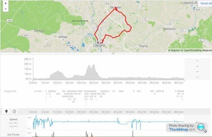
Here's one I made earlier. I had little snippets of Strava, but the app kept dropping out, so I filled in the gaps, then joined it all together. Obviously, speed isn't very realistic, but it gets the job done.
Edited by Solocle on Monday 18th May 14:10
Solocle said:
Yeah, you feed it a route, it'll produce an activity! So, the strava route tool, with the veloviewer extension, as long as you know which tiles you nabbed, will be fine.
I used that approach to see which tiles a prospective route would tick off, you can delete the activity, and the tiles will go back to unvisited. Although it did once confuse the veloviewer extension, a new activity solved that one.
Here's one I made earlier. I had little snippets of Strava, but the app kept dropping out, so I filled in the gaps, then joined it all together. Obviously, speed isn't very realistic, but it gets the job done.
Your assistance greatly appreciated on this. I had no idea that site existed. Shouldn't really be using it to "fake a ride" like this, but this is bothering me more than it ought to. So I've managed to sort it out, not as complex as I feared. I think I've nabbed a couple of extra tiles where the "fake" route clipped corners of unridden tiles. No great shakes, I fully expect to ride most, if not all, of these tiles again at some point. My obsessive behaviour is worse than I thought it was though. Time to take a long hard look at myself to see if I can't manage to do a "hard reset" on what makes me tick!I used that approach to see which tiles a prospective route would tick off, you can delete the activity, and the tiles will go back to unvisited. Although it did once confuse the veloviewer extension, a new activity solved that one.
Here's one I made earlier. I had little snippets of Strava, but the app kept dropping out, so I filled in the gaps, then joined it all together. Obviously, speed isn't very realistic, but it gets the job done.
Glad you got it sorted YellowJack, that would have really pissed me off!
Just playing with veloviewer trying to work out what my maximum number of tiles in one day was - turns out it was 216. I ended up using the calendar summary and finding the darkest colour as I couldn't find a more succinct way of doing it.
My ride yesterdady to fill in a some blanks added 22 new tiles in 100km of riding.
Gassing Station | Pedal Powered | Top of Page | What's New | My Stuff