Veloviewer. Who is using it, and what do you get from it?
Discussion


Solocle said:
Yeah, I, umm, have a lot of rides already planned...
Here's how I deal with the 2 ridgeway tiles I've left to do, along with some of Purbeck:
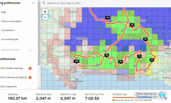
For the coastal tiles along the A353, there's a bit of out-and back to be done if you don't want to take a stroll with the bike along the coast path. Don't bother with the road down to the PGL Adventure Centre in Osmington (signed for village hall too) though. It's gated so you can't get far enough along to nab the tile. Get down to the Riviera Hotel (Bowleaze Cove Way) and access the grassed area above the hotel for that one. I learned the hard way on that coastal strip, and ended up walking my bike up and down steps quite a lot between Ringstead Bay and Osmington Mills. Similar results can, I think, be achieved by just trundling down the 'T' roads to the coast at each point along the way, thereby sticking to tarmac for the most part.Here's how I deal with the 2 ridgeway tiles I've left to do, along with some of Purbeck:
I do as you do, and suss out some of my plans on Strava routes (easiest way of accurately predicting mileage) or Google Earth/Streetview. I just don't bother saving the routes as my Gamins aren't reliable enough on their own for navigation, and don't afford me the flexibility I like to change destination while already out on the route.
Finally got around to nabbing the two tiles at the end of the shingle spit out to Hurst Castle today.
33 miles for two measly tiles! Was fun though, struggling out on the shingle, on my £53 eBay bargain Cannondale Backroads. The trip back was gusty too as the cloud had rolled in and the wind speed picked up.
None of it was of any use to my Max Square, but I added 1 tile to my Max Cluster. As far as I can see, that accounts for the coast in it's entirety from an Impossible tile at Fawley Oil Refinery to the Range Walks at Tyneham. Any further south and I'm going to need a boat! I'll get the Range Walks before firing starts again at the end of the month, hopefully.
Expansion now has to go north and west if I want to increase my Max Square, due to the sea and that pesky tile at Fawley. Either that or start again north of the Fawley tile and expand east on the other side of Southampton Water? That could work as I'd eventually be able to join up with my previous cluster based on Farnborough.
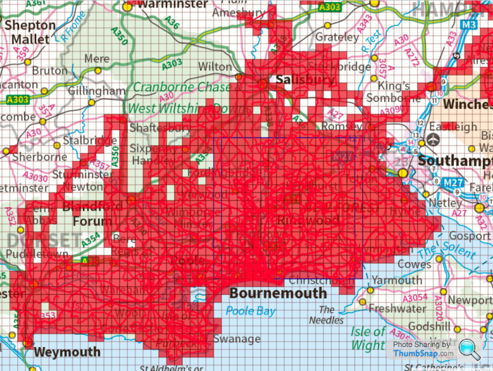
I'm still static at an 18x18 Max Square, but as the screenshot shows, I'm close to expanding that if I fill in a few tiles here and there. Next mission? Probably to fill in as many tiles as possible to "colour in" the OS Landranger map sheet 195 (Bournemouth & Purbeck). Then extend from Shaftesbury north to Warminster, where I think I'll begin to meet some off-limits tiles on MOD artillery ranges. Once I've worked out the limit of exploitation that way, I'll fill in tiles heading south and east. Then maybe go east, across Southampton Water, and join my current Cluster/Square up with my old hunting grounds out of Farnborough. I can see the Festive 500 being interesting this year - I'll try to combine it with some VeloViewer tiling if at all possible...
33 miles for two measly tiles! Was fun though, struggling out on the shingle, on my £53 eBay bargain Cannondale Backroads. The trip back was gusty too as the cloud had rolled in and the wind speed picked up.
None of it was of any use to my Max Square, but I added 1 tile to my Max Cluster. As far as I can see, that accounts for the coast in it's entirety from an Impossible tile at Fawley Oil Refinery to the Range Walks at Tyneham. Any further south and I'm going to need a boat! I'll get the Range Walks before firing starts again at the end of the month, hopefully.
Expansion now has to go north and west if I want to increase my Max Square, due to the sea and that pesky tile at Fawley. Either that or start again north of the Fawley tile and expand east on the other side of Southampton Water? That could work as I'd eventually be able to join up with my previous cluster based on Farnborough.
I'm still static at an 18x18 Max Square, but as the screenshot shows, I'm close to expanding that if I fill in a few tiles here and there. Next mission? Probably to fill in as many tiles as possible to "colour in" the OS Landranger map sheet 195 (Bournemouth & Purbeck). Then extend from Shaftesbury north to Warminster, where I think I'll begin to meet some off-limits tiles on MOD artillery ranges. Once I've worked out the limit of exploitation that way, I'll fill in tiles heading south and east. Then maybe go east, across Southampton Water, and join my current Cluster/Square up with my old hunting grounds out of Farnborough. I can see the Festive 500 being interesting this year - I'll try to combine it with some VeloViewer tiling if at all possible...
Edited by yellowjack on Tuesday 18th August 00:40
I've gone nuts. Officially.
Yesterday I set off with the bike in the car, planning a ride to tie together some outlying clusters and fill in a few gaps north of Salisbury. Or the alternative plan was to claim a few tiles to expand my Max Square south of the city.
Somehow, though, I ended up near Warminster. I spotted a sign for Shearwater and remembered the lake from when my boys were small and we used to go there for a winter walk and a hot chocolate with toasted teacakes from the cafe there. So off I went, further west than any of the maps I'd brought would cover.
Couldn't park at Shearwater, it was far too busy. But got a space in a small car park on the road between the Safari Park and Center Parcs. And off I went, not always completely certain I was going the right way, but I sniffed out a fair few byways and bridleways and eventually got back to the car without having to ask directions or push the 'Back To Start' on my Garmin (never ever used that feature so far).
Apart from a rude, and quite aggressive farmer type (if you're going to get pissed off with "c ts" wandering off the bridleways, it might be an idea to stop taking down the signs for them?) and a possibly bent mech hanger (I lost the bottom three sprockets on the cassette when a stick went into the jockey wheels) it was a fabulous day out.
29 new tiles ridden in the end, but they don't touch any existing groups/clusters of tiles. So instead of tidying up my Explorer map, I've made it more messy! Still, it was lovely riding out that way, so I'll have an excuse to go back again. A Strava follower has suggested a route to me that would get me from Warminster to Glastonbury, and perhaps on to the north Somerset coast (if I square myself away the night before and get an early start). I'm tempted to give that a go. Not today though, with the wind blowing like it is.
Anyway, here's the relevant portion of my Veloviewer map...

Note to self: Buy the OS map sheets west of Warminster. Guessing your way around the countryside just leads to annoying "holes" in clusters of tiles. Sheets 183 and 194 would do for a start.
Yesterday I set off with the bike in the car, planning a ride to tie together some outlying clusters and fill in a few gaps north of Salisbury. Or the alternative plan was to claim a few tiles to expand my Max Square south of the city.
Somehow, though, I ended up near Warminster. I spotted a sign for Shearwater and remembered the lake from when my boys were small and we used to go there for a winter walk and a hot chocolate with toasted teacakes from the cafe there. So off I went, further west than any of the maps I'd brought would cover.
Couldn't park at Shearwater, it was far too busy. But got a space in a small car park on the road between the Safari Park and Center Parcs. And off I went, not always completely certain I was going the right way, but I sniffed out a fair few byways and bridleways and eventually got back to the car without having to ask directions or push the 'Back To Start' on my Garmin (never ever used that feature so far).
Apart from a rude, and quite aggressive farmer type (if you're going to get pissed off with "c
ts" wandering off the bridleways, it might be an idea to stop taking down the signs for them?) and a possibly bent mech hanger (I lost the bottom three sprockets on the cassette when a stick went into the jockey wheels) it was a fabulous day out.29 new tiles ridden in the end, but they don't touch any existing groups/clusters of tiles. So instead of tidying up my Explorer map, I've made it more messy! Still, it was lovely riding out that way, so I'll have an excuse to go back again. A Strava follower has suggested a route to me that would get me from Warminster to Glastonbury, and perhaps on to the north Somerset coast (if I square myself away the night before and get an early start). I'm tempted to give that a go. Not today though, with the wind blowing like it is.
Anyway, here's the relevant portion of my Veloviewer map...
Note to self: Buy the OS map sheets west of Warminster. Guessing your way around the countryside just leads to annoying "holes" in clusters of tiles. Sheets 183 and 194 would do for a start.
Comacchio said:
My OCD would have me filling in all those blanks  good on you!
Every time I set off for a ride I intend to fill in some of the blanks, or extend some straight lines to box in sections to fill in later. But I frequently end up getting distracted by some "interesting looking" byways or bridleways, or like this time I go somewhere "for old time's sake". I'll fill in those blanks eventually, but in the meantime... good on you!..."Ooh, look! A Squirrel!"...
ETA: Many of the "blanks" further north and east are from before I had learned about VeloViewer tiling. So I rode for 6 years (from joining VV/Strava) from Farnborough merrily missing out tiles because I stuck to tried and tested loops, or simply never got around to riding thiose particular roads. If i'd known about tiling before I moved to Bournemouth, there definitely wouldn't be quite as many blank tiles up that way...

Edited by yellowjack on Sunday 23 August 14:14
dirtbiker said:
I'd played with the annual summary infographics in the past but have just signed up for the tiles game - sounds like fun!
Hugely entertaining. I only wish I'd joined Strava earlier now, because I have ridden vast swathes of Essex, Suffolk, and North Yorkshire but none of that is recorded on Strava so it doesn't count toward my tiling tally.I also wish I'd signed up to the paid-for version of VeloViewer sooner. Because then I'd have paid attention to filling in some gaps in my cluster based out of my last house before I moved, instead of that part of my tiling map looking like a colander!
As it is, tiling has inspired me to go places I otherwise would never have considered going. And in doing so it's meant I have found some fabulously low-traffic roads which will get me to places I want to ride again far more pleasantly than the 'prime' routes I'd always ridden before.
I will say though, that there are an infuriating number of tiles I've ridden past on dozens of rides, but never actually entered because they are at the end of a 'No Through Road' hamlet or village. So I didn't ride up that road because there was no point as it didn't go anywhere. Now, though, I'll often point my bike up a pointless road, byway, or bridleway on the off chance it'll yield another tile for my cluster! Some I've got planned for future rides are a road to a golf club, the driveway of a grand country house hotel, and a through route that passes the front of another stately home that's now a school. Never bothered with it before as it was signed only for the school, but poring over the OS maps its definitely a PROW and will definitely tick off another tile.
Seriously addictive stuff for an idiot such as me!
I will say, though, that one or two tiles I've ticked off recently have required what can only be described as "mild trespassing" to claim them. No breaking and entering or property damage involved, but passing signs warning of 'No Public Access' etc. Or riding on a disused railway line. Or using a private level crossing. But those tiles I'll only ever visit once - I don't intend to make a nuisance of myself on them.
An observation, from a recent tiling ride...
The Longleat Estate. And a nearby estate. I turned off a road following my nose and a compass direction, hoping to cut through woodland instead of getting buzzed by cars on a NSL 'A' road.
Upon turning the sign at the first gate said "No Unauthorised Vehicular Access Beyond This Point". OK, I thought. I'm on a bicycle.
Next gate, before a small row of cottages said "No Access For Unauthorised Persons. No Public Right Of Way". Damn. That tile is out then...
...but then I saw a sign on another gate. Invoking 'Implied Licence', I proceeded to a point where I could read the sign. It said "Dogs On Leads Please. Wildlife Conservation Area". This surely means the landowner permits/expects dog walkers to use the route?
By this point I could see yet another sign on yet another gatepost. So once again, using 'Implied Licence', I approached this sign. "Longleat Estate. Forestry Operations In Progress. Obey All signs And Keep To Paths and Forest Roads. Keep Off Timber Stacks". Well this was the clincher for me. Clear and obvious permission to ride the vehicle tracks through the forest.
Anyone else noticed similar discouraging signs (clearly home made in many cases) past properties on PROWs or Permissive Paths? Only further up a road or lane there's a County Council Byway or Bridleway sign?
I'm finding it more than a little irritating, to be honest. I'd like the Byway or Bridleway signs to be placed at the point where these (so-called) 'Private Roads' turn off the public highway, so that it's clear that there is a PROW along them, just not in motorised vehicles.
I'd also like to see destination finger-boards for cyclists at junctions. Frequently I know where I'm going next, but following the existing finger-boards you are directed onto the largest/busiest of the available routes, the one the council/local residents want through traffic to go by. But bicycle traffic would be better kept separate from motor traffic, so it would be nice to see some destination finger-boards for cyclists and walkers. They could be in much smaller fonts - I've no issue with having to stop to read them - but I've lost count of the number times I've missed a tile because my mental list of villages has seen me following signs aimed at drivers which go the long way around to the next one on the list, whereas what I needed (for tiling and for road safety reasons) was the tiny single-track road with moss growing down the middle which both goes through the tile I needed and also sees next to nothing in terms of motor traffic, so is far safer to ride on.
Just musings really. I have this bad habit of riding off the edge of the map I brought with me, you see...
Comacchio said:
...Edit:
That lone tile at the bottom... quite surprised it coloured in considering how little I was in it:
You get quite a few that way!That lone tile at the bottom... quite surprised it coloured in considering how little I was in it:
I hit a couple of "extras" on my 100 mile ride yesterday. As you say, it's surprising how little ground you need to cover within a tile to claim it. But I still try to get at least half-way into a tile if I'm deliberately visiting one, just to be on the safe side.
One tip to make sure you get those "extras" is to open the ride directly on VeloViewer. Looking at the web page (as opposed to the Strava app) it's the 'View On VeloViewer' button on the left hand panel, just above the edit button. On the main activity page map (in VeloViewer) the GPS trace takes the form of a series of straight lines between waypoints. Where roads are twisty-turny, this can mean you're docked a tile if the route is right on the edge of a tile. By opening the individual activity, you get the extra waypoints recorded by your GPS and a more "natural" looking trace.
No riding for me today. Rotten weather earlier in the day kept me at home, then when the sun came out it was time to visit my mother-in-law in her care home (bookings only at the moment) which was pre-booked. So while I waited for the clock to tick round I got out my laptop and my maps, and marked up all the unridden tiles I could. Now my brain hurts!
It would be so much simpler if VeloViewer had used OS 1km grid squares as tiles. As it is, the tiles are not square, and they are neither plumb nor level, so plotting them onto an OS map can't be done by measuring from any line, whether you drew it onto the map or the OS cartographers put it there. No, you gotta plot the lines by visually interpreting where they cross map features such as junctions, bridges, contour lines, etc.
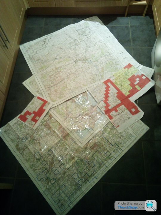
I'm also beginning to doubt my sanity. As much as I love the look and feel of paper maps, and the act of stopping to read the map and plot the next few miles worth of turns, The cost of them is staggering when you add it up. Five ordinary 1:50,000 scale maps is £40 to buy. Want the waterproof versions? £75 for the same five sheets. It starts to make electronic downloads and the hardware to view them on look cheap! I need three more 1:50k sheets already, to fill in gaps and draw my two "clusters" together. I'm printing off small sections on A4 paper to cover gaps in my map coverage right now, but it's far from ideal. And it's not just the price that makes paper maps difficult. Availability isn't great either. Probably because not so many people bother with them these days, so shops are less likely to stock them.
I'm hoping to ride again tomorrow, but there are still thundery showers forecast. The wet I can deal with, but there aren't many places to take shelter from lightening strikes and torrential downpours when you're several miles from the nearest village, and even if you were in a town or village, you can hardly knock on some random door and beg for shelter with Covid-19 on the rampage still!
As for this...
Comacchio said:
Best tenner I've spent in a long time.
...i couldn't agree more. I wish I'd signed up to it long ago. I was in right at the start when it was free. Then it went to subscription and I muddled along with the limited functionality for years. Right up until someone explained tiling to me. I was intrigued by it, so I thought "what the heck - it's only a tenner". It's barely a couple of beers at a gig, ffs! Why on earth did I not pay up earlier?!? I'd never have ridden half the places I currently have if it hadn't been for VV Tiling...Current state of play for me -

- and my map marking confirms that my current square can't grow beyond 29x29 from it's current base line. Two of those three tiles just below and to the left of the 'G' in Grateley are tiles wholly within the ranges at Porton Down. Not being funny, but I'm happy with one head and five fingers on each hand! If I move it west a bit I can reach 35x35 before the artillery impact area at Larkhill prevents expansion northwards. Go further west and the sea-to-sea limit is 36 tiles between Lyme Regis and Burnham-On-Sea. To get more than a potential 36x36 I'd have to concentrate on the area north of Fareham and east of Grateley, but that would mean 100 mile rides every time I went tiling pretty soon. As it is the shortest round trip for two tiles is 40 miles, and after that it's 50 miles, then one tile for a 60 mile ride. As much as I love tiling, it's costly in terms of time, tyres, chains and cassettes...
Edited by yellowjack on Thursday 27th August 22:57
Harpoon said:
I have a target of having OS Explorer maps for the whole of the UK and I'm very slowly collecting them as we go on holiday to different places.
I get them from https://dash4it.co.uk/ordnance-survey-maps./series... - £6.29 for Landranger or Explorer. Sign up for their mailing list and they always have an extra discount code available for maps. I purchased two more Explorer sheets this month and that totalled £10.78 inc delivery.
Thanks for that link! The water resistant 'Active' sheets are £4.50 cheaper there than elsewhere.I get them from https://dash4it.co.uk/ordnance-survey-maps./series... - £6.29 for Landranger or Explorer. Sign up for their mailing list and they always have an extra discount code available for maps. I purchased two more Explorer sheets this month and that totalled £10.78 inc delivery.
As for having them all? I had every UK 1:50,000 scale sheet in my possession at one point. I used to run our regiment's map library (OK, it was 200+ cardboard tubes in a broom cupboard) and had ten copies of each sheet. Whenever there was an update, I'd pilfer one of the previous edition and take it home, if it was somewhere I was likely to go. Fast forward to a house move and my wife persuaded me that I needed to thin out my map collection, so anything with an edition or reprint date earlier than 1985 was tossed. A decision I now bitterly regret, because even where major infrastructure changes have occurred it's possible to work around them. And the basic navigation info on them seldom changes. Hills, villages, churches, etc have been where they are for centuries.
When I retired from the army I was at RE EOD (bomb disposal). Tech had moved on by then so no physical library of maps was kept. Instead the operations room had it's own Geo Tech NCO, and he had a huge printer and could print custom OS map sheets on demand. If I were still serving I could probably get any custom sheets I wanted, so I could make sure I was never planning a ride around the edge of two (or more) adjoining sheets. It's a source of regret that I didn't think ahead and curate a decent collection of maps before I lost access to them. And you could always justify a request for a map. Map reading in and of itself is regarded as training...
Gareth1974 said:
yellowjack said:
Current state of play for me -
To get more than a potential 36x36 I'd have to concentrate on the area north of Fareham and east of Grateley, but that would mean 100 mile rides every time I went tiling pretty soon. As it is the shortest round trip for two tiles is 40 miles, and after that it's 50 miles, then one tile for a 60 mile ride. As much as I love tiling, it's costly in terms of time, tyres, chains and cassettes...
Can you get a train or drive to somewhere like Andover, and do a few rides from there? I enjoyed a big ride to Derbyshire the other day, but 50 miles of my ride was over well ridden territory, I’m thinking of driving up there next time so I can spend more of my ride exploring new areas without spending 4 hours of the ride just getting there.To get more than a potential 36x36 I'd have to concentrate on the area north of Fareham and east of Grateley, but that would mean 100 mile rides every time I went tiling pretty soon. As it is the shortest round trip for two tiles is 40 miles, and after that it's 50 miles, then one tile for a 60 mile ride. As much as I love tiling, it's costly in terms of time, tyres, chains and cassettes...
Edited by yellowjack on Thursday 27th August 22:57
Planned excursions include MTBing from Warminster, and from Tidworth, to nab tiles on Salisbury Plain. And some road biking out of both too, to fill in large gaps or draw smaller outlying clusters together. But I still plan to do a decent portion of my riding from home. Even if it means coming back from a ride without bagging any new tiles.
Solocle said:
Wednesday's tiling was finishing off the A37. I arranged it so that it was mostly downhill, at least!
Only 7 tiles, but a bump to a 19x19 max square.
Commitment right there! Did you get wet? Only 7 tiles, but a bump to a 19x19 max square.
My tiling mission today was without the bike. I took a hike from Tyneham Village, near Lulworth to grab some tiles that cannot be accessed on two wheels. Bikes are forbidden on the range walks, and even if they weren't it's debatable whether those coast path hills are even remotely rideable...
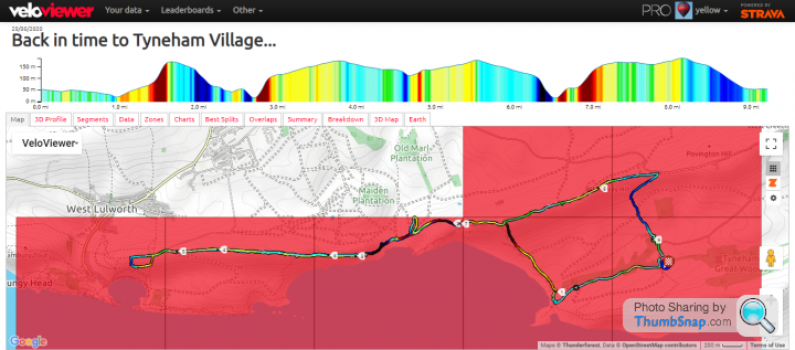
Just the 7 tiles walked today, and only four of them count as new ones. Views were amazing. Weather was impressive to say the least. Thunder, Lightning, Hailstones, Wind, Rain. Today had it all, along with a new pair of boots and the resulting blisters.
https://www.strava.com/activities/3978789176
Hoping my feet recover for tomorrow now. I've got a walk down a shingle spit to Hurst Castle to come tomorrow lunchtime...
Edited by yellowjack on Friday 28th August 23:58
loudlashadjuster said:
It won't take more than a couple of 'fill-in' rides to take me to 13x13 here though.

Can't believe there's a blank less than 7 km from my house!
Same here. My original Max Square was based out of a previous address, so I had to start again when I moved. And I just had a look and I have five blank tiles less than ten miles from my previous home. I can't believe I missed them in seven years of Strava membership. I even had a dig into them and they all have roads through them. I guess if I'd found VeloViewer tiling before I'd moved I would have had them ticked off pretty swiftly though. The trouble is, if I go back there for a "fill-in ride" or two, then I'll soon move my Max Square back there too. Can't believe there's a blank less than 7 km from my house!
I'm planning a long one today, just as soon as the laundry is out to dry. Not sure what I'll do with it, but it's tempting to try to bring my two distinct clusters together if I can...
Damn you all, and your heresy! I'll not have talk of efficient route planning in this thread, d'you hear?

New month. Same old yellowjack...
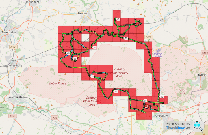
https://www.strava.com/activities/3998425564
Promised myself to stick to tarmac this time. Within a mile of the start I was on a dirt and grass bridleway. But out of what I count as 78 tiles covered, 71 of them were new ones for 90 miles ridden. And I could have been more efficient if I'd not bimbled down to see Stonehenge in the moonlight, because I covered old ground riding back up The Packway through Larkhill to get back to the car.
And there it is. The confession. I drove to Larkhill because I couldn't bear the thought of inefficiently riding through literally dozens of tiles I'd ridden many times already only to grab a small handful of new ones at the far end. I'm going to do more driving to places to "go tiling" too. I figure the whole point of tiling is to explore new places, and so I've changed my stance on driving to go for a ride.
One glaring error in that single blank tile. I simply forgot to make a turn down a farm track/bridleway to collect that one. The big "hole" in the middle? A lot of that was pretty much beyond attempting this time out. It's the Larkhill/Westdown Artillery Range Impact Area, and the ranges were live, with mortars firing close to a byway I was riding on. I'll wait for a leave period and hope the byways across the impact area are open when the range flags aren't flying. I was pretty shocked when I looked at the 'Ride Every Tile' heatmap the other day. I thought half a dozen or more tiles would be impossible to get in that area, but only one is actually unridden and marked impossible. Even the "forbidden" tiles around Imber ranges have been ticked off, some by more than just one or two tilers. I'm tempted to contravene the bylaws myself for a trundle down Berril Valley, to see the training obstacles I helped build there nearly 30 years ago. Although I don't fancy a court appearance just to grab a few tiles in a silly online game!
Anyway, this...
...is where that ride puts my overall. In the context of Max Square expansion it was useless, especially if there is one (or more) impossible tiles there. And I didn't manage to tack it on to my Max Cluster this time out either. But it brings my neat 18-tile Tidworth cluster closer to linking up with the main body of my tiles. That gap between the A342 in the north and the A303 in the south is ripe for a MTB excursion given the number of byways criss-crossing it.
After that? I should probably plan a ride or three to connect the Longleat and Tidworth clusters to the main cluster, and then fill in as many of the gaps around Salisbury and Romsey as possible (less the two or three on the Porton Down Ranges). Then thicken up the "cable" connecting my old cluster with the new one through/around Winchester. I also had a plan to colour in Portland and extend northwards from there, but I'll probably just go back to random splatters of tiles in new places completely unconnected to existing clusters. Which will leave me with horribly inefficient long rides to claim only a handful of isolated blank tiles. As much fun as this game is, it can be incredibly frustrating when you make a planning error or forget to take a turn and end up leaving a blank on it's own in a sea of red tiles. Anyway, Christmas is coming, and with it the Festive 500 (hopefully). Which hopefully will involve some tiling this year. Add to that the new King Alfred's Way off road cycle loop and there should be plenty to keep this tiling lark interesting for the foreseeable...
New month. Same old yellowjack...
https://www.strava.com/activities/3998425564
Promised myself to stick to tarmac this time. Within a mile of the start I was on a dirt and grass bridleway. But out of what I count as 78 tiles covered, 71 of them were new ones for 90 miles ridden. And I could have been more efficient if I'd not bimbled down to see Stonehenge in the moonlight, because I covered old ground riding back up The Packway through Larkhill to get back to the car.
And there it is. The confession. I drove to Larkhill because I couldn't bear the thought of inefficiently riding through literally dozens of tiles I'd ridden many times already only to grab a small handful of new ones at the far end. I'm going to do more driving to places to "go tiling" too. I figure the whole point of tiling is to explore new places, and so I've changed my stance on driving to go for a ride.
One glaring error in that single blank tile. I simply forgot to make a turn down a farm track/bridleway to collect that one. The big "hole" in the middle? A lot of that was pretty much beyond attempting this time out. It's the Larkhill/Westdown Artillery Range Impact Area, and the ranges were live, with mortars firing close to a byway I was riding on. I'll wait for a leave period and hope the byways across the impact area are open when the range flags aren't flying. I was pretty shocked when I looked at the 'Ride Every Tile' heatmap the other day. I thought half a dozen or more tiles would be impossible to get in that area, but only one is actually unridden and marked impossible. Even the "forbidden" tiles around Imber ranges have been ticked off, some by more than just one or two tilers. I'm tempted to contravene the bylaws myself for a trundle down Berril Valley, to see the training obstacles I helped build there nearly 30 years ago. Although I don't fancy a court appearance just to grab a few tiles in a silly online game!
Anyway, this...
...is where that ride puts my overall. In the context of Max Square expansion it was useless, especially if there is one (or more) impossible tiles there. And I didn't manage to tack it on to my Max Cluster this time out either. But it brings my neat 18-tile Tidworth cluster closer to linking up with the main body of my tiles. That gap between the A342 in the north and the A303 in the south is ripe for a MTB excursion given the number of byways criss-crossing it.
After that? I should probably plan a ride or three to connect the Longleat and Tidworth clusters to the main cluster, and then fill in as many of the gaps around Salisbury and Romsey as possible (less the two or three on the Porton Down Ranges). Then thicken up the "cable" connecting my old cluster with the new one through/around Winchester. I also had a plan to colour in Portland and extend northwards from there, but I'll probably just go back to random splatters of tiles in new places completely unconnected to existing clusters. Which will leave me with horribly inefficient long rides to claim only a handful of isolated blank tiles. As much fun as this game is, it can be incredibly frustrating when you make a planning error or forget to take a turn and end up leaving a blank on it's own in a sea of red tiles. Anyway, Christmas is coming, and with it the Festive 500 (hopefully). Which hopefully will involve some tiling this year. Add to that the new King Alfred's Way off road cycle loop and there should be plenty to keep this tiling lark interesting for the foreseeable...
I feel bad. This thread is like the complete opposite of a support group or intervention. Groups like Alcoholics Anonymous aim to help addicts out of their cycle of addiction. This thread just acts as an enabler and encourages an addiction to cycling. For this I am truly sorry...
Seriously, though, it's been encouraging. Especially seeing what challenges riders in other parts of the country face, whether it's weather, terrain, or large spaces devoid of roads. It's also good to know that I'm not the only one with annoying blanks in the middle of large clusters of tiles.
I'm sure if it was a job of work I'd be a whole lot more efficient, and target those gaps more urgently. I'd also expand my max square and cluster in a more ordered fashion. But I'm trying to keep it fun for myself, so I'll continue to make those daft random offshoot trips like the Longleat adventure a while back. The Isle Of Wight still looks tempting. It'd be nice to do that at the "perfect" time of year though. After the holiday crowd have packed up and gone home, but before autumn and winter really start to bite.
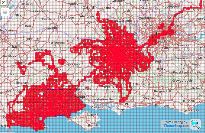
I'm not sure what I expected when I started the thread. But I certainly didn't think it would still be active. I definitely didn't think there were very many people into the Explorer tiling when I got into it myself. No offence, but I'm a bit of an odd fish and I thought it would only be fellow oddballs and then only a few of them. But you all seem remarkably sane and, dare I say it, "normal".
As an aside, I have long considered myself to be a long(er) distance cyclist. But looking at my Eddington Score recently and I've noticed that it's like tiling. The higher numbers are exponentially harder to achieve. My score is 70. That's 70 recorded rides of at least 70 miles. One more ride of 71 miles (or more) nets me a score of 71. But to get to 80 would take another 29 days of 80 (or more) miles. To get it to 100 would take another 66 days of 100 miles of more! Something of a sideshow distraction maybe, but another (longer term) target to aim for.
Thanks for contributing, everyone. Keep riding, keep tiling, and keep encouraging the rest of us. Seeing what you all get up to really does inspire me to get out some days, especially when the weather isn't at it's best.

Seriously, though, it's been encouraging. Especially seeing what challenges riders in other parts of the country face, whether it's weather, terrain, or large spaces devoid of roads. It's also good to know that I'm not the only one with annoying blanks in the middle of large clusters of tiles.
I'm sure if it was a job of work I'd be a whole lot more efficient, and target those gaps more urgently. I'd also expand my max square and cluster in a more ordered fashion. But I'm trying to keep it fun for myself, so I'll continue to make those daft random offshoot trips like the Longleat adventure a while back. The Isle Of Wight still looks tempting. It'd be nice to do that at the "perfect" time of year though. After the holiday crowd have packed up and gone home, but before autumn and winter really start to bite.
I'm not sure what I expected when I started the thread. But I certainly didn't think it would still be active. I definitely didn't think there were very many people into the Explorer tiling when I got into it myself. No offence, but I'm a bit of an odd fish and I thought it would only be fellow oddballs and then only a few of them. But you all seem remarkably sane and, dare I say it, "normal".
As an aside, I have long considered myself to be a long(er) distance cyclist. But looking at my Eddington Score recently and I've noticed that it's like tiling. The higher numbers are exponentially harder to achieve. My score is 70. That's 70 recorded rides of at least 70 miles. One more ride of 71 miles (or more) nets me a score of 71. But to get to 80 would take another 29 days of 80 (or more) miles. To get it to 100 would take another 66 days of 100 miles of more! Something of a sideshow distraction maybe, but another (longer term) target to aim for.
Thanks for contributing, everyone. Keep riding, keep tiling, and keep encouraging the rest of us. Seeing what you all get up to really does inspire me to get out some days, especially when the weather isn't at it's best.
Wasted almost an hour of today's ride chasing my tail in some old watermeadows belonging to William Pleydell-Bouverie, 9th Earl of Radnor.
Map said there was a footpath and a bridleway that both crossed the River Avon. Those coloured discs with little Wiltshire County Council arrows on posts agreed with the map - there was definitely a bridleway here. So I followed the arrows and the map, found the bank of the river, but no crossing. Presumed I was in the wrong place, followed the river, no dice. Asked a woman who appeared to have a bridge over an old Navigation in her back garden. No bridge between Britford and Alderbury. Never has been. The footpath crossing was a punt, but that hasn't been there for decades. The bridleway crossing? Well she thought you might just ford the river on horseback. But it was too deep for that on a bicycle. I could see Longford Castle, and the stone bridge over the Avon which took the Earl's driveway over the river. But no way to get to, or over it. Gave in and retraced my steps. Got wet up to my knees crossing the now disused irrigation ditches in the watermeadow, had to hold the bike over my head. Won't be going back there in a hurry.
Then wasted another half hour pushing the bike through dense woodland to stay out of sight of workers on the Clarendon Park estate. I eventually found my way onto the Clarendon Way long distance footpath, but that went east to west, where I needed to go south, so I brazenly "styled it" down the main driveway to a closed automatic gate. Panicking a little at the thought of being trapped, I made to turn around and go over a fence and across a field to make my escape, but the sensor on the gate opened it from the inside and I casually rolled out onto the public highway beyond.
https://www.strava.com/activities/4007243898
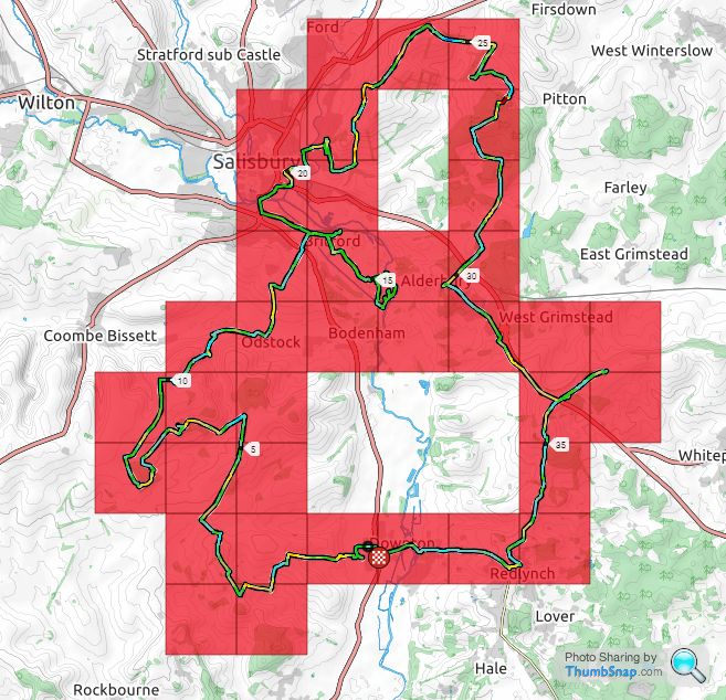
Annoyingly, there's a single blank tile still. It was raining so I decided not to get my map wet. Trying to remember the turns I'd planned on making worked to an extent, but I missed one tile, the topmost of the blanks in this screenshot. And there are no roads through it, just a footpath and a bridleway. The other blanks I'd already coloured in during previous rides. 37 tiles ridden to claim 11 new ones, legs stung to buggery by nettles, and wet shoes and shorts from my ditch-crossing shenanigans. Thankfully, though, you only need one ride through a tile to claim it, so no need to go anywhere near those worst spots again...
First time out on my MTB in ages, and it felt good to not have to worry about mud, flint, and slick wet grass. A pair of Nobby Nics meant I was floating over rough patches where I'd be cautiously picking my way around them on my road bike, and to an extent on my "gravel" bike too.
ETA: My resolve broke today.Instead of "saving" on of these new tiles as a "stopper" to effect a bigger jump in my Max Square at some later stage, I decided that leaving a single blank tile on it's own was silly. So I rode it and that bumped my Max Square up from 18x18 to 19x19. Five tiles in a neat row near Romsey would buy me a 20x20 Square too. But some of that batch would require a ride along the A27. Got to ride them at some point though, so I'll go have a look-see, maybe drive the route first to assess the road and traffic levels before I commit to riding it. There is a way to avoid going along the A27, but that would be a very inefficient route, and mean making multiple crossings of the A27.
Map said there was a footpath and a bridleway that both crossed the River Avon. Those coloured discs with little Wiltshire County Council arrows on posts agreed with the map - there was definitely a bridleway here. So I followed the arrows and the map, found the bank of the river, but no crossing. Presumed I was in the wrong place, followed the river, no dice. Asked a woman who appeared to have a bridge over an old Navigation in her back garden. No bridge between Britford and Alderbury. Never has been. The footpath crossing was a punt, but that hasn't been there for decades. The bridleway crossing? Well she thought you might just ford the river on horseback. But it was too deep for that on a bicycle. I could see Longford Castle, and the stone bridge over the Avon which took the Earl's driveway over the river. But no way to get to, or over it. Gave in and retraced my steps. Got wet up to my knees crossing the now disused irrigation ditches in the watermeadow, had to hold the bike over my head. Won't be going back there in a hurry.
Then wasted another half hour pushing the bike through dense woodland to stay out of sight of workers on the Clarendon Park estate. I eventually found my way onto the Clarendon Way long distance footpath, but that went east to west, where I needed to go south, so I brazenly "styled it" down the main driveway to a closed automatic gate. Panicking a little at the thought of being trapped, I made to turn around and go over a fence and across a field to make my escape, but the sensor on the gate opened it from the inside and I casually rolled out onto the public highway beyond.
https://www.strava.com/activities/4007243898
Annoyingly, there's a single blank tile still. It was raining so I decided not to get my map wet. Trying to remember the turns I'd planned on making worked to an extent, but I missed one tile, the topmost of the blanks in this screenshot. And there are no roads through it, just a footpath and a bridleway. The other blanks I'd already coloured in during previous rides. 37 tiles ridden to claim 11 new ones, legs stung to buggery by nettles, and wet shoes and shorts from my ditch-crossing shenanigans. Thankfully, though, you only need one ride through a tile to claim it, so no need to go anywhere near those worst spots again...
First time out on my MTB in ages, and it felt good to not have to worry about mud, flint, and slick wet grass. A pair of Nobby Nics meant I was floating over rough patches where I'd be cautiously picking my way around them on my road bike, and to an extent on my "gravel" bike too.
ETA: My resolve broke today.Instead of "saving" on of these new tiles as a "stopper" to effect a bigger jump in my Max Square at some later stage, I decided that leaving a single blank tile on it's own was silly. So I rode it and that bumped my Max Square up from 18x18 to 19x19. Five tiles in a neat row near Romsey would buy me a 20x20 Square too. But some of that batch would require a ride along the A27. Got to ride them at some point though, so I'll go have a look-see, maybe drive the route first to assess the road and traffic levels before I commit to riding it. There is a way to avoid going along the A27, but that would be a very inefficient route, and mean making multiple crossings of the A27.
Edited by yellowjack on Thursday 3rd September 23:48
dirtbiker said:
Good effort there yellowjack!
Out on the MTB last night and did a new route which netted two new tiles taking my total up to 1043. Still only on a 6x6 square around Aberdeen but I spent a bit of time building routes on Strava to close some gaps when I get a chance to get out on the road bike.

Tempted to get a better GPS than the Elemnt Bolt I currently use - does anyone have an Elemnt Roam and rate it?
No idea about the Elemnt Roam, I'm still using a combo of Garmin Edge 500 and ForeRunner 910XT.Out on the MTB last night and did a new route which netted two new tiles taking my total up to 1043. Still only on a 6x6 square around Aberdeen but I spent a bit of time building routes on Strava to close some gaps when I get a chance to get out on the road bike.
Tempted to get a better GPS than the Elemnt Bolt I currently use - does anyone have an Elemnt Roam and rate it?
But I can see that you're another coastal tiler with restricted options for expansion. Which makes growing a Max Square more challenging, as there are no short ride options for you to the east, and every time you expand west you put new tiles further and further away. With my Max Square, I've now got clusters of blank tiles to the north east, and to the west. With no easy way to join them into a single ride (time/distance against me). I'll get them eventually, but I seem to spend as much time planning and marking maps now as i do riding!
Solocle said:
I've only just started driving to do a ride... about 1h 30m diameter, although extremal points might be 2h+!
I'm there already. My nearest "batch" of blank tiles is 19 miles from home for 7 tiles near Sixpenny Handley. Even at an optimistic pace that's at least a three hour ride (round trip) for me. Then it's a 25 mile ride to a blank tile near Bere Regis. Then the next nearest area of interest is 30 miles away around Romsey. That would mean two and a half to three hours each way of covering old ground. It's hard to justify the time spent, especially as the initial roads to get out of Bournemouth can be a bit manic with drivers getting frustrated at each other trying to get into town either to work or get to the beaches. I'd rather drive to Wildest Wiltshire now and start riding quieter roads in cleaner air right from the first turn of the pedals. I swore I wouldn't do this when I started "tiling" but I didn't quite appreciate just how quickly I'd reach the point where blank tiles were so far away from home. I had a decent week this week, managing 4 rides totaling 205 miles. I'm out of the game now until Thursday, visiting Wells, among other places, while my wife has a week off work. Fingers crossed the weather is kind next week too, because I'll be missing out on riding in some excellent (forecast) cycling weather this week...
Solocle said:
A follow up to yesterday's, I grabbed Hamworthy/Central Poole, and the Port of Poole (it looked like it might be hard one, and I did get told off for taking photos on private land... "Oh, sorry, I think I'm a bit lost" did the trick
)N.b. I think that's the first (and almost certainly will be the only) BCP tile that I have, but yellowjack doesn't!
Edited by Solocle on Sunday 13th September 09:24
I tried to get that one but couldn't find my way past fences and locked gates within the port area. Had thought there might be a way through the yacht club but it was at the height of the Covid restrictions so many businesses were closed and no ferries running.
I'm planning to get four with a trip to Brownsea Island at some point. Either a hike, a run, or just a pleasant walk around the island with my wife. Gonna need to book it though, through the National Trust website, or the ferry won't take me across...
Commitment there! I like it. I've got a single tile strip between Basingstoke way and Romsey that I could probably widen to jack my Max Cluster up significantly.
Quiet week this week for me, just a few walks and a short local ride for bread. My wife's week off is over now though, so I'm hoping to get out on a bike tomorrow if I can find one that will keep air in it's tyres!
Solocle said:
A few rides and a few drives, nothing longer than 125 km! I even went beyond bare minimum today, and filled in some gaps (I never did tiling from Oxford, so it looks something like a target at a shotgun range).
Even if the A34 was just too convenient to ignore...
I had a closer look at my Port Of Poole ride...Even if the A34 was just too convenient to ignore...
I can't believe how close I got. Literally two car lengths further south and I'd have claimed the damned thing!

Today's (yesterday's? It's well past midnight after all...) tiling trip...
...a bit "scattergun" in the end, with plenty of gaps in the coverage. But not bad given that a) I wasn't planning to go north of Romsey today, and b) I don't have any mapping for the bulk of this area.
Pretty much guesswork once I was off OS Landranger Sheet 184 (Salisbury and The Plain) so I'm happy with what I got. I'll print some 'mini maps' with the gaps on for my next trip that way, unless I buy a map beforehand. Wondering now if I need to brave the A34 too. The A27 was OK tonight, traffic wise, but the surface of the road was appalling. And the A36 was quiet enough too.
Oh, and I zip-tied a spare tyre under the saddle pack through the saddle rails just in case. Only it wasn't there when I stopped to turn my lights on just south of Andover. It's a Vittoria Zafiro Pro Slick, with red sparky's tape wrapped around it, if anyone finds it!
Gassing Station | Pedal Powered | Top of Page | What's New | My Stuff