Veloviewer. Who is using it, and what do you get from it?
Discussion


yellowjack said:
ukbabz said:
yellowjack said:
Agreed. I'd love to hear more about these 1330 tiles in a smidgin under 3 weeks. From what I know (almost nothing) my imagination is running wild...
A bit of a convoluted route between Lands End and John O'Groats had me averaging between 130 and 154 new tiles a day as we zigzagged up the UK. Lots of beautiful landscapes and scenery. Taking in some iconic bridges - Clifton suspension, Severn Bridge, Ironbridge, Forth Road and the Kessock bridge. Also ticked off a few of the 100 climbs from Simon Warrens book - Rundlestone (Dartmoor), Cheddar Gorge, Cairnwell (Glenshee) and the Lecht -- as well as the "wrong side" of fleet moss and the devils beef tub (# 160). I wish I'd put a bigger rear cassette as the 20% climbs on a 36-30 were a bit tough on the quads!I'd like to vent one thing -- f
 king headwind. 9 and half days of it! Even when we got to the north coast of Scotland the wind had swung to be a strong easterly for the final push!
I once had a notion about doing Lands End to John O'Groats and back, only sticking to coastal roads. Then Timmy-bloody-Mallett went and did a lap of the UK, and I realised that unless I get a job I'll not have the money to even consider such a ride (it would need to be a credit-card-tour mixed with some wild camping, I think), but if I had a job then finding time to do it would be the issue. It'll probably never happen (for me) now and even if I did "tile the outline of Great Britain" it would have to be done in smaller chunks. Still, it's good to dream...
It worked out about £1500 a head (sharing a room in hotels) excluding transfers to Lands End and back from Inverness - as well as buying own evening grub. So not the cheapest option but it did OK.
Have raised £1k on top for Macmillan (with work chipping in another £350) so there was some good from it all - but it wasn't a charity ride as such. More me raising funds alongside something I was going to do.
Solocle said:
One easy task could be to catch the train up to London town and tile North East. One relatively simple ride should connect up to Bishops Stortford if my eye is right.
I myself have plans up there on Saturday, but with a view to connecting west, only doing an eastern radial:


I see what you are getting at. Confession time. Almost everything centred on Saffron Walden is recreated from using the velotoes (spelling?) website. Only the PH Cambridge-London ride (TdF stage route), RideLondon, and three other rides are actual recorded GPS data. The recreated stuff was created from detailed route notes I kept in a hand-written cycling diary, with distance/speed data taken from a Cateye cycle computer. There was a LOT more riding I'd done around there in the previous five years, but I'd kept no notes so recreating those routes was very much off limits (my own rules) as I couldn't accurately plot actual routes. That frustrates me, but then where do you stop? Childhood rides with stabilisers to the park? Youthful rides in the dark hours to meet girls in parks? I've got oodles of routes in South Wales to re-ride with GPS, along with oodles of routes around Ripon, N. Yorkshire, that I'd like to re-ride to get a more "complete picture" of all the places I've ridden, but obviously I'm not able to nail down dates and exact routes for those either. I suppose I could call the cut-off point at the date when GPS cycle computers were first available to buy, or back-date things to when I first joined VeloViewer. But to keep things honest (mostly with myself) I have only recreated routes and rides I had documentary evidence for. I'd love to go back to north Essex, Suffolk and Cambridgeshire though. Some really good cycling roads there which can be extremely quiet when it comes to traffic. It's just too far away for me to justify at the moment. I myself have plans up there on Saturday, but with a view to connecting west, only doing an eastern radial:
One vague plan in my head is to use the motorway network to define goals for cycling. Not to ride on them, obviously. But the M23/A23 looks like a decent 'limit of exploitation' to aim for heading east, then have a cluster bound by the M25, M4, and M5 down to Exeter in the west. What that would give me in Max Square terms I haven't really worked out. And if I ever achieved that? It would be easy then to pick the next M-way or arterial trunk road as a new target to ride to. Another idea I've toyed with is "colouring in" whole counties. Berkshire is small and I'm about half way to completing that already, mostly from legacy GPS rides pre-dating VeloViewer membership. I'm close to complete on Hampshire and Dorset, I've already got a good chunk of Wiltshire covered (although there'll be necessary 'Impossible Tile' gaps in that county) and Surrey is well under way too. I've also made a start on Somerset and West Sussex.
I might be repeating myself, but the artillery ranges at Larkhill, the live fire ranges at Imber, and the off limits parts of Porton Down ranges are a big "blocker" for me. They're why I had two entirely separate 33x33 Squares on the go at one point. Impossible for me to expand directly north right now, and unlikely that the situation will change in my lifetime. I toyed with accessing some of those range tiles illicitly, as some of them have got Strava/VV activity on them, but security is tighter up there than it ever used to be.
In short, I have three main areas that would yield the best tiling returns. Lambourn and Berkshire Downs above the M4, the south eastern corner of my cluster around Chichester/Goodwood/Arundel, and west toward Yeovil, Glastonbury and Wells, possibly linking up with an isolated cluster around Weston-super-Mare. I just need to spend less time on the internet chit-chatting about it and planning routes I never ride, and more time on my bike. There isn't an easy way to keep this hobby up, you just have to ride your bike, and that's what I haven't been doing enough of until fairly recently. Now that I'm riding regularly again, and I've extended myself to over 80 miles in one ride, I have the confidence in my legs and equipment to once again look at rides solely planned around ticking off more of those pesky VeloViewer tiles.
yellowjack said:
I see what you are getting at. Confession time. Almost everything centred on Saffron Walden is recreated from using the velotoes (spelling?) website. Only the PH Cambridge-London ride (TdF stage route), RideLondon, and three other rides are actual recorded GPS data. The recreated stuff was created from detailed route notes I kept in a hand-written cycling diary, with distance/speed data taken from a Cateye cycle computer. There was a LOT more riding I'd done around there in the previous five years, but I'd kept no notes so recreating those routes was very much off limits (my own rules) as I couldn't accurately plot actual routes. That frustrates me, but then where do you stop? Childhood rides with stabilisers to the park? Youthful rides in the dark hours to meet girls in parks? I've got oodles of routes in South Wales to re-ride with GPS, along with oodles of routes around Ripon, N. Yorkshire, that I'd like to re-ride to get a more "complete picture" of all the places I've ridden, but obviously I'm not able to nail down dates and exact routes for those either. I suppose I could call the cut-off point at the date when GPS cycle computers were first available to buy, or back-date things to when I first joined VeloViewer. But to keep things honest (mostly with myself) I have only recreated routes and rides I had documentary evidence for. I'd love to go back to north Essex, Suffolk and Cambridgeshire though. Some really good cycling roads there which can be extremely quiet when it comes to traffic. It's just too far away for me to justify at the moment.
One vague plan in my head is to use the motorway network to define goals for cycling. Not to ride on them, obviously. But the M23/A23 looks like a decent 'limit of exploitation' to aim for heading east, then have a cluster bound by the M25, M4, and M5 down to Exeter in the west. What that would give me in Max Square terms I haven't really worked out. And if I ever achieved that? It would be easy then to pick the next M-way or arterial trunk road as a new target to ride to. Another idea I've toyed with is "colouring in" whole counties. Berkshire is small and I'm about half way to completing that already, mostly from legacy GPS rides pre-dating VeloViewer membership. I'm close to complete on Hampshire and Dorset, I've already got a good chunk of Wiltshire covered (although there'll be necessary 'Impossible Tile' gaps in that county) and Surrey is well under way too. I've also made a start on Somerset and West Sussex.
I might be repeating myself, but the artillery ranges at Larkhill, the live fire ranges at Imber, and the off limits parts of Porton Down ranges are a big "blocker" for me. They're why I had two entirely separate 33x33 Squares on the go at one point. Impossible for me to expand directly north right now, and unlikely that the situation will change in my lifetime. I toyed with accessing some of those range tiles illicitly, as some of them have got Strava/VV activity on them, but security is tighter up there than it ever used to be.
In short, I have three main areas that would yield the best tiling returns. Lambourn and Berkshire Downs above the M4, the south eastern corner of my cluster around Chichester/Goodwood/Arundel, and west toward Yeovil, Glastonbury and Wells, possibly linking up with an isolated cluster around Weston-super-Mare. I just need to spend less time on the internet chit-chatting about it and planning routes I never ride, and more time on my bike. There isn't an easy way to keep this hobby up, you just have to ride your bike, and that's what I haven't been doing enough of until fairly recently. Now that I'm riding regularly again, and I've extended myself to over 80 miles in one ride, I have the confidence in my legs and equipment to once again look at rides solely planned around ticking off more of those pesky VeloViewer tiles.
If I'd been really bolshy that North London ride could have quasi-legitimately seen me ticking off tiles by riding the M25... Never underestimate the ability of a council to be cretins! They were about to inescapably divert an all purpose roundabout onto the motorway. One vague plan in my head is to use the motorway network to define goals for cycling. Not to ride on them, obviously. But the M23/A23 looks like a decent 'limit of exploitation' to aim for heading east, then have a cluster bound by the M25, M4, and M5 down to Exeter in the west. What that would give me in Max Square terms I haven't really worked out. And if I ever achieved that? It would be easy then to pick the next M-way or arterial trunk road as a new target to ride to. Another idea I've toyed with is "colouring in" whole counties. Berkshire is small and I'm about half way to completing that already, mostly from legacy GPS rides pre-dating VeloViewer membership. I'm close to complete on Hampshire and Dorset, I've already got a good chunk of Wiltshire covered (although there'll be necessary 'Impossible Tile' gaps in that county) and Surrey is well under way too. I've also made a start on Somerset and West Sussex.
I might be repeating myself, but the artillery ranges at Larkhill, the live fire ranges at Imber, and the off limits parts of Porton Down ranges are a big "blocker" for me. They're why I had two entirely separate 33x33 Squares on the go at one point. Impossible for me to expand directly north right now, and unlikely that the situation will change in my lifetime. I toyed with accessing some of those range tiles illicitly, as some of them have got Strava/VV activity on them, but security is tighter up there than it ever used to be.
In short, I have three main areas that would yield the best tiling returns. Lambourn and Berkshire Downs above the M4, the south eastern corner of my cluster around Chichester/Goodwood/Arundel, and west toward Yeovil, Glastonbury and Wells, possibly linking up with an isolated cluster around Weston-super-Mare. I just need to spend less time on the internet chit-chatting about it and planning routes I never ride, and more time on my bike. There isn't an easy way to keep this hobby up, you just have to ride your bike, and that's what I haven't been doing enough of until fairly recently. Now that I'm riding regularly again, and I've extended myself to over 80 miles in one ride, I have the confidence in my legs and equipment to once again look at rides solely planned around ticking off more of those pesky VeloViewer tiles.

As it was, I had no desire to ride on an ALR smart motorway, at least without phoning ahead to get them to close said motorway while I was on my way.
 Really I just planned for the plod to give the council an absolute reaming. But alas, I had a train home to catch before they'd set it up.
And I did end up walking past that massive start of motorway regulations sign... to use the pedestrian crossing.


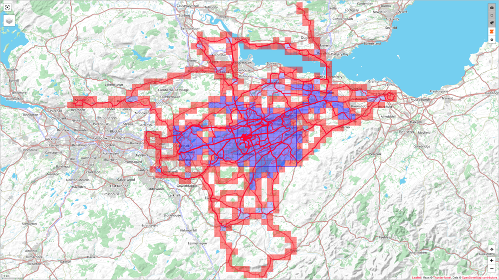
The accidental cluster.
First off, last month, I just set out on a ride north, aiming for the north. Totally not in shape, so I got a train home from Kemble. I also spotted an opportunity to do some tiling once I decided I wasn't riding 250 miles, or even the 200 km consolation target of Coventry.
I bought an open return ticket to do some more tiling shenanigans.
I actually thought this cluster would be a bit of a dead end. Cotswolds=Hills. But as the train has to go via Reading, a ticket up to Oxford would be super cheap. Roll on yesterday. And a bus replacement service between Didcot and Hanborough.
So I returned to Kemble, and then tiled up to Moreton in Marsh. Hilly bugger of a route, but I pulled it off.

And I also got an open return ticket from Moreton-in-Marsh . No more deliberations about the next phase:

The driving objective should be obvious on this map:

First off, last month, I just set out on a ride north, aiming for the north. Totally not in shape, so I got a train home from Kemble. I also spotted an opportunity to do some tiling once I decided I wasn't riding 250 miles, or even the 200 km consolation target of Coventry.
I bought an open return ticket to do some more tiling shenanigans.
I actually thought this cluster would be a bit of a dead end. Cotswolds=Hills. But as the train has to go via Reading, a ticket up to Oxford would be super cheap. Roll on yesterday. And a bus replacement service between Didcot and Hanborough.
So I returned to Kemble, and then tiled up to Moreton in Marsh. Hilly bugger of a route, but I pulled it off.
And I also got an open return ticket from Moreton-in-Marsh
. No more deliberations about the next phase:The driving objective should be obvious on this map:


Only got in to Veloviewer at the start of the summer having seen this thread. Ponies up my tenner to drag in past years’ Strava data, but I didn’t bother with Strava until March 2021 when I signed up for a charity challenge that wanted Strava activities to link to.
Mostly around the homelands but Etape Caledonia and Loch Ness Etape in 2021 and 2022 respectively give some nice smatterings of squares up north.
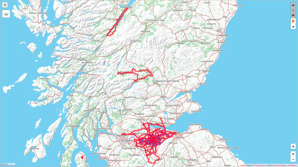
Fair bit of colouring in to be done, but it’s already been good for making me ride new places not just same old routes.
Mostly around the homelands but Etape Caledonia and Loch Ness Etape in 2021 and 2022 respectively give some nice smatterings of squares up north.
Fair bit of colouring in to be done, but it’s already been good for making me ride new places not just same old routes.
| Date | 4th June | 21st July | 28th Aug |
| Tiles | 812 | 848 | 917 |
| km/square | 6.702 | 7.200 | 7.519 |
| Max Square | 7x7 | 9x9 | 10x10 |
| Max Cluster | 87 | 145 | 195 |
Edited by emicen on Tuesday 29th August 07:51
Yesterday and today spent filling in the gap between Derby and Moreton-in-Marsh. Yeesh.
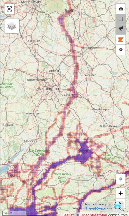
That cluster spans from South Yorkshire, through Derbyshire, Leicestershire, and Warwickshire, to Oxfordshire and Gloucestershire, then finally on to Wiltshire.
That cluster spans from South Yorkshire, through Derbyshire, Leicestershire, and Warwickshire, to Oxfordshire and Gloucestershire, then finally on to Wiltshire.
Edited by Solocle on Friday 8th September 16:19


Hmmm.
I'm not sure if my VeloViewer/Strava sync is "broken". I'm just not getting any alerts at all on there, yet both accounts are working OK. I've checked everything I know of to make sure settings are all good, but nothing.
Same with my Wandrer Earth account. If I log in to it it shows me messages for new miles, but nothing gets attached to the comments in my Strava account.
I've had some issues (still having them if I'm honest) with my Google Search results switching to Yahoo when I hit 'enter', and I've had to reset permissions for various apps while trying to fix that. I've also had a new 'phone recently and started running Garmin and Strava apps on it. Is it as simple as now needing to install VeloViewer as an app on my phone (along with Wandrer Earth)? Or is there something (potentially very obvious) that I'm missing to fix this? My 'summitbag' achievements get added to Strava automatically, for comparison, and that's not an app on my phone.
Hardware changes recently? A new Samsung Galaxy A14 phone. A new Garmin Instinct 2 Solar watch. Software changes (as far as I'm aware) are just the Strava and Garmin apps on the phone.
I don't think I've recorded a single bike ride since buying this watch, so that may be an issue, as there may have been no actual increases in VeloViewer tile coverage to report. I suppose I'd better get out and go somewhere I know I'll earn new VV tiles before doing anything drastic (like trying to solve a problem that isn't there). But the Wandrer Earth thing? That's definitely not working properly.
My absence from VV tiling has mainly been down to issues with confidence and anxiety after a collision wrote off my road bike in July, added to my MTB and "frankenbike" Cannondale both being in need of parts (and some labour) to get them properly road/trailworthy, parts I'm struggling to fund at the moment.
I hope to "get back on it" soon, just need to square my head away and get my MTB suspension serviced, among other things.
yellowjack said:
Hmmm.
I'm not sure if my VeloViewer/Strava sync is "broken". I'm just not getting any alerts at all on there, yet both accounts are working OK. I've checked everything I know of to make sure settings are all good, but nothing.
Same with my Wandrer Earth account. If I log in to it it shows me messages for new miles, but nothing gets attached to the comments in my Strava account.
I've had some issues (still having them if I'm honest) with my Google Search results switching to Yahoo when I hit 'enter', and I've had to reset permissions for various apps while trying to fix that. I've also had a new 'phone recently and started running Garmin and Strava apps on it. Is it as simple as now needing to install VeloViewer as an app on my phone (along with Wandrer Earth)? Or is there something (potentially very obvious) that I'm missing to fix this? My 'summitbag' achievements get added to Strava automatically, for comparison, and that's not an app on my phone.
Hardware changes recently? A new Samsung Galaxy A14 phone. A new Garmin Instinct 2 Solar watch. Software changes (as far as I'm aware) are just the Strava and Garmin apps on the phone.
I don't think I've recorded a single bike ride since buying this watch, so that may be an issue, as there may have been no actual increases in VeloViewer tile coverage to report. I suppose I'd better get out and go somewhere I know I'll earn new VV tiles before doing anything drastic (like trying to solve a problem that isn't there). But the Wandrer Earth thing? That's definitely not working properly.
My absence from VV tiling has mainly been down to issues with confidence and anxiety after a collision wrote off my road bike in July, added to my MTB and "frankenbike" Cannondale both being in need of parts (and some labour) to get them properly road/trailworthy, parts I'm struggling to fund at the moment.
I hope to "get back on it" soon, just need to square my head away and get my MTB suspension serviced, among other things.
That sucks, getting back out there after a crash is the best thing to calm down, but easier said than done.I'm not sure if my VeloViewer/Strava sync is "broken". I'm just not getting any alerts at all on there, yet both accounts are working OK. I've checked everything I know of to make sure settings are all good, but nothing.
Same with my Wandrer Earth account. If I log in to it it shows me messages for new miles, but nothing gets attached to the comments in my Strava account.
I've had some issues (still having them if I'm honest) with my Google Search results switching to Yahoo when I hit 'enter', and I've had to reset permissions for various apps while trying to fix that. I've also had a new 'phone recently and started running Garmin and Strava apps on it. Is it as simple as now needing to install VeloViewer as an app on my phone (along with Wandrer Earth)? Or is there something (potentially very obvious) that I'm missing to fix this? My 'summitbag' achievements get added to Strava automatically, for comparison, and that's not an app on my phone.
Hardware changes recently? A new Samsung Galaxy A14 phone. A new Garmin Instinct 2 Solar watch. Software changes (as far as I'm aware) are just the Strava and Garmin apps on the phone.
I don't think I've recorded a single bike ride since buying this watch, so that may be an issue, as there may have been no actual increases in VeloViewer tile coverage to report. I suppose I'd better get out and go somewhere I know I'll earn new VV tiles before doing anything drastic (like trying to solve a problem that isn't there). But the Wandrer Earth thing? That's definitely not working properly.
My absence from VV tiling has mainly been down to issues with confidence and anxiety after a collision wrote off my road bike in July, added to my MTB and "frankenbike" Cannondale both being in need of parts (and some labour) to get them properly road/trailworthy, parts I'm struggling to fund at the moment.
I hope to "get back on it" soon, just need to square my head away and get my MTB suspension serviced, among other things.
On a better note, I forgot to mention my 9 mile ride in September from Lacock Abbey that added 318 to my max cluster


ZetecTDCI said:
Ticked over 10,000 tiles today. Now at 10,010, square = 14, max cluster = 779
Do you travel a lot to ride? That's a massive number tiles and a relatively small cluster - I can see the appeal of driving around to find themMine is currently.
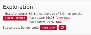
5453 tiles, average of 7.049 km per tile
Max square 25x25
Max Cluster: 960
ukbabz said:
ZetecTDCI said:
Ticked over 10,000 tiles today. Now at 10,010, square = 14, max cluster = 779
Do you travel a lot to ride? That's a massive number tiles and a relatively small cluster - I can see the appeal of driving around to find themMine is currently.
5453 tiles, average of 7.049 km per tile
Max square 25x25
Max Cluster: 960
I thought my ratio of tiles/cluster was bad, and I'm way ahead of both of you on that score...
For instance, a square of 26x26 is 676 tiles, so that's a cluster of 576 inside. In theory my 6000 tiles could make a 77*78 rectangle, with a cluster of 5700. (94.9% of tiles).
Or, it could make a circle with a radius of 43 squares. (5809 tiles), and have a cluster therein of 5541, achieving 95.4%. In the limit the circle would be the most efficient shape for a cluster.
I'm not sure what you mean by a bad ratio of tiles:squ or tiles:cluster.
I do travel to ride quite often - mostly weekend rides are with my wife and we like to go to new roads.
I think its mostly down to about 17 strava years of bike holidays, not doing off-road, local geography and not keen to ride the unpleasant bits.
I do travel to ride quite often - mostly weekend rides are with my wife and we like to go to new roads.
I think its mostly down to about 17 strava years of bike holidays, not doing off-road, local geography and not keen to ride the unpleasant bits.
Edited by ZetecTDCI on Tuesday 14th November 22:24
ZetecTDCI said:
I'm not sure what you mean by a bad ratio of tiles:squ or tiles:cluster.
I do travel to ride quite often - mostly weekend rides are with my wife and we like to go to new roads.
I think its mostly down to about 17 strava years of bike holidays, not doing off-road, local geography and not keen to ride the unpleasant bits.
It's the number of total squares you've visited vs squares in your cluster etc.I do travel to ride quite often - mostly weekend rides are with my wife and we like to go to new roads.
I think its mostly down to about 17 strava years of bike holidays, not doing off-road, local geography and not keen to ride the unpleasant bits.
Edited by ZetecTDCI on Tuesday 14th November 22:24
For instance, I have a ton of tiles from doing LEJOG, but until recently they contributed nothing to my cluster. Then, a bit of further work to draw a line, and you'd expect a 1 in 3 ratio - to get a cluster, you need a 3 wide set.


Edited by Solocle on Tuesday 14th November 23:01
ZetecTDCI said:
Yes I understand that, but why is a low or high ratio bad ?
I don't think it's either good or bad. It's just an observation, and perhaps unusual among "tilers" because for a time there was only the 'Max Square' to aim for. The 'Max Cluster' came along later to cater for folk who have difficulty in building a square. Think about riders in Cornwall, for instance. Or Canada, where huge areas of wilderness and lakes galore interrupt a square. And riders who live near conflict zones, or borders with unfriendly countries. I've got issues with a number of 'Strictly No Access' MOD sites. Others have issues with oil refineries. I think there's at least one 'Impossible Tile' entirely on a USAF base in the UK. Sometimes we're guilty of taking it a bit too seriously, but I think this is just a turn of phrase, not a judgement. I'm annoyed that I didn't find VeloViewer until after I'd moved house from Farnborough to Bournemouth. I had to go back a couple of times to mop up single tiles and small groups here and there. Or I didn't have to but I wanted to. It frustrates me that it was easier to expand my Max Square up there, but now I'm within a couple of tiles of the coast it's more difficult because I'm limited by the sea.
I'm struggling anyway at the moment. Very little cycling means I've only picked up the odd single tile here and there on walks. A 26 new tile return since September 2022 isn't exactly setting the world of Tiling alight. I keep telling myself I'll get back to it, (both cycling and tiling) but there's always some excuse not to. Currently it's being a bike down, and the weather at the top of the excuse list. Whatever, though. Overthinking it is my worst enemy if I'm honest, and because there are no prizes I probably should just get a bike out and get out there, even if the nearest unridden tile for me is at least a 60 mile (round trip) ride away.
Ultimately it's no big deal. It's up to you how you use VeloViewer and "do tiling" if you're into that. Comparing yourself to others? Do it if you you want to, and although I do pay some attention to folk with more impressive tile tallies, I'm into it more for the spur it gives (gave?) me to explore routes and areas I'd never gone down or into before. I like the data, and "colouring in" the tile map. It's also a great tool for finding segments and old rides/walks/runs, especially when I haven't got many rides in a more distant area. Much easier than trying to sift through years of activites on Strava.
Gassing Station | Pedal Powered | Top of Page | What's New | My Stuff