WW2 Photo-recon Maps. Possible Locations?
Discussion


airlana said:
Currently I'm researching a 681 Sqn Spitfire pilot who 'failed to return' after a photo-recon mission over Burma in Sept 1943... Look forward to any information others may be able to contribute.
I take it you already know of the Spitfire Society but if not: www.spitfiresociety.comTheir magazine 'DCO' always has entries from people in your position looking for info - drop them a line and you never know what might turn up.
tank slapper said:
Here is what I tried to do originally, but couldn't because it was the wrong place. This is obviously the correct location, as the pier and roads match up nicely:
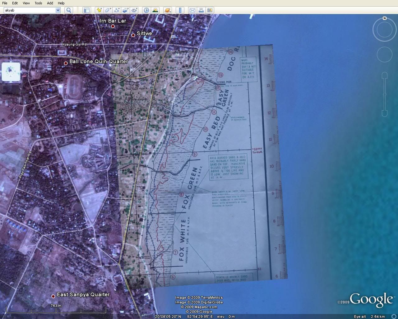
If you want it, I have put the google earth .kml file here.
Wow, Thank you. If you want it, I have put the google earth .kml file here.
Edited by tank slapper on Friday 30th October 15:11
I wish my Grandad could see that. I never could understand why he was drawing D-Day maps when he was in the Far East!
Edited by dr_gn on Friday 30th October 15:24
tank slapper said:
Here is what I tried to do originally, but couldn't because it was the wrong place. This is obviously the correct location, as the pier and roads match up nicely
Well done ts and that saves me some work, thank you.Somewhere I have an old 1930's [I think] town map of Akyab. Pretty basic, but so was the town in those days.
Will see if I can find it.
airlana
airlana said:
tank slapper said:
Here is what I tried to do originally, but couldn't because it was the wrong place. This is obviously the correct location, as the pier and roads match up nicely
Well done ts and that saves me some work, thank you.Somewhere I have an old 1930's [I think] town map of Akyab. Pretty basic, but so was the town in those days.
Will see if I can find it.
airlana
Here is a quick photo of the whole map, when viewed at 100% is very clear. I could send you the original photo if you like?
Cheers.

Edited by dr_gn on Friday 30th October 17:50
dr_gn said:
Airlana,
Here is a quick photo of the whole map, when viewed at 100% is very clear. I could send you the original photo if you like?
Cheers.
Fantastic, thank you so much. I've enlarged it again on your 100% and with a bit of work in Photoshop comesHere is a quick photo of the whole map, when viewed at 100% is very clear. I could send you the original photo if you like?
Cheers.
out clear as a bell. So much info on the map - great stuff.
You'll see on the shore line near the point "B.O.A.C Jetty". Akyab was a stopping off point for the BOAC flying boats enroute to Singapore. Yet I've never seen a photo of the flying boats at Akyab. Plenty of photos at other locations. Ok it's a slim chance, but has anyone a photo?
Re the airfield photo at the beginning of this thread. Are there any others that look like the same field?
If so, could you please post them. It's a good photo and would very much like to indentify it.
regards airlana
airlana said:
dr_gn said:
Airlana,
Here is a quick photo of the whole map, when viewed at 100% is very clear. I could send you the original photo if you like?
Cheers.
Fantastic, thank you so much. I've enlarged it again on your 100% and with a bit of work in Photoshop comesHere is a quick photo of the whole map, when viewed at 100% is very clear. I could send you the original photo if you like?
Cheers.
out clear as a bell. So much info on the map - great stuff.
You'll see on the shore line near the point "B.O.A.C Jetty". Akyab was a stopping off point for the BOAC flying boats enroute to Singapore. Yet I've never seen a photo of the flying boats at Akyab. Plenty of photos at other locations. Ok it's a slim chance, but has anyone a photo?
Re the airfield photo at the beginning of this thread. Are there any others that look like the same field?
If so, could you please post them. It's a good photo and would very much like to indentify it.
regards airlana
Here are some photographs of everything I have of my Grandad's wartime work:


A colleague identified the large city above as Bangkok
 It's right - the large monument structure is still there today.

Let me know if there is anything of interest. I will try to get better images of the airstrip later.
Cheers.
EDIT:
Here's a photo of the airstrip photo. Not too good - I will have to scan it at high resolution for you if you like. I'm almost certain the aircraft are Japanese Zero's, along with some twin engined bombers. They look great in 3D, as do the wooded valleys; it's like looking down on a scale model. Everything appears to have depth - individual palm trees look like tiny cardboard cut-outs.

Edited by dr_gn on Saturday 31st October 20:31
airlana said:
What's the photo at bottom right with all the papers in the first photo?
It appears to be a photograph of an OS Map of somewhere in Britain. Next to it is a photograph of what appears to be a topographical model of some area, and the small card has silhouettes of ships on it.Gassing Station | Boats, Planes & Trains | Top of Page | What's New | My Stuff