The windy winter and occasional snow thread 2017/2018
Discussion


The Scottish ski resorts have so much snow! Glencoe had to dig out the upper lift yesterday the powder was nearly level with top of the tows in places, mostly due to drifting. I have never fallen over so much skiing, than yesterday due to the viz not being ideal. Powder everywhere, looks like it will be bloody awesome for the rest of the week.
Other resorts are reporting huge dumps of the stuff & its forecast for inversion for the rest of the week - so get yer skates on
Other resorts are reporting huge dumps of the stuff & its forecast for inversion for the rest of the week - so get yer skates on


Late to the party on this weather thread this year, but is this a winter appreciation area or can we moan about it? Up in the North East we've had a lot of snow fall, plenty of sleet and most days barely above 4 Deg. I've had my fill of this winter, probably because autumn was so short (Winter arrived in November) and there's rarely been a high pressure period where it's been clear and cold and dry. Summer was a fairly cool and cloudy affair so it's compounding the effect!
Can't wait now for the temps to start to rise to double figures and it all dries out a bit.
Can't wait now for the temps to start to rise to double figures and it all dries out a bit.

Time for some meat on the bones:
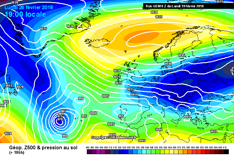
The SSW often allows a Scandi high to form - and as you can see from the first image, this shows a lovely East-West sausage shape high dragging cold air westwards along it's southern flank - directly at us in this case. Now, high pressure by itself is unlikely to bring anything but bone dry winds from a continental source, so we either hope for lake effect snow or some instability. Lake effect snow (ie Thames/Kent Streamer) is best formed when the land is cold and the sea is warm - so December is best for this. We may need to hope for some small low pressure systems or troughs to materialise (ie France 2 weeks ago).
With this chart (the GEM model, not the best), the really cold stuff is only hitting the South/SE. For once we are better lined up than the North. ECM also pushes the air south. GFS/ICON are more of a smack in the UK face style.
Interesting to see the permanent Azores High replaced by a low! Best conditions normally have a low pressure around the Italian peninsular too.
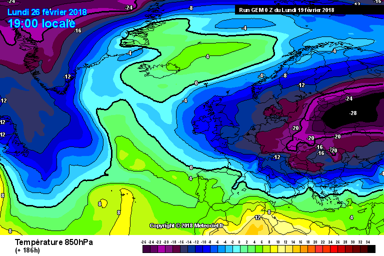
These are the upper air temperatures, -8 is required for almost certain snow (conditions can vary). Some charts have shown -20 reaching he UK and -14 hitting Ireland. Typically add 8 degrees for sea level temps.
The SSW often allows a Scandi high to form - and as you can see from the first image, this shows a lovely East-West sausage shape high dragging cold air westwards along it's southern flank - directly at us in this case. Now, high pressure by itself is unlikely to bring anything but bone dry winds from a continental source, so we either hope for lake effect snow or some instability. Lake effect snow (ie Thames/Kent Streamer) is best formed when the land is cold and the sea is warm - so December is best for this. We may need to hope for some small low pressure systems or troughs to materialise (ie France 2 weeks ago).
With this chart (the GEM model, not the best), the really cold stuff is only hitting the South/SE. For once we are better lined up than the North. ECM also pushes the air south. GFS/ICON are more of a smack in the UK face style.
Interesting to see the permanent Azores High replaced by a low! Best conditions normally have a low pressure around the Italian peninsular too.
These are the upper air temperatures, -8 is required for almost certain snow (conditions can vary). Some charts have shown -20 reaching he UK and -14 hitting Ireland. Typically add 8 degrees for sea level temps.

Gassing Station | The Lounge | Top of Page | What's New | My Stuff