The windy winter and occasional snow thread 2017/2018
Discussion


PugwasHDJ80 said:
JakeT said:
Does feel cold at the moment. Between reading and Newbury the feels like temperature is a cool -7.
There is definitely an enclave of use who live between Rweading and Newbury on tuis weather thread- bet we get no snow!
 Already got Wednesday off as we're meant to be going in to London!
ST_Nuts said:
Looks like there's a good chance the whole of the south will get dumped with a load of snow on Wednesday 
Sounds about right, I’m covering my girlfriends shift at work that day so it’s Sod’s law that I do that on a day when all hell breaks loose at airports around the south. (To go ski touring in Switzerland, oh the irony...)
wiliferus said:
PugwasHDJ80 said:
JakeT said:
Does feel cold at the moment. Between reading and Newbury the feels like temperature is a cool -7.
There is definitely an enclave of use who live between Rweading and Newbury on tuis weather thread- bet we get no snow!
So, where are we?
Cold arrives tomorrow night in to Monday.
North Sea shower activity starts in earnest in a stiff wind from the East on Monday. North Sea is slightly warmer than average, which will help create the showers.
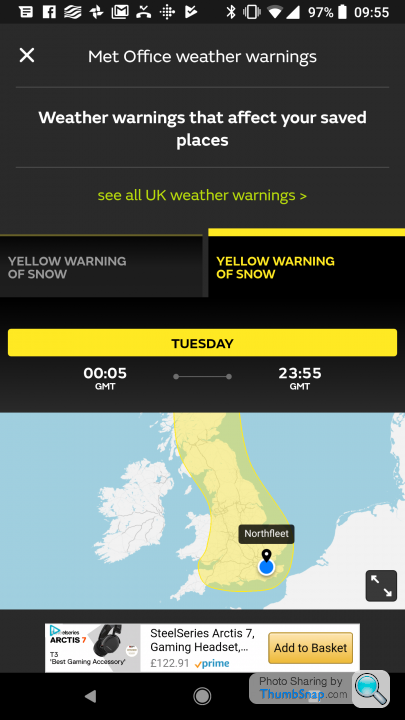
Tuesday - first real snow 'event' will effect somewhere on the North Sea Coast. There's a low pressure trough which is likely to bring prolonged and heavy snow. Likely location is Geordieland (please not Edinburgh!).

Tuesday may also see a Kent Streamer, and a Wash Streamer too.

After that Friday is a key day. Models are showing a large area of low pressure coming up from the South. The models will struggle with this as they aren't used to computing a deep pool of cold air over the UK. GFS is now modelling this to move far up the UK, dragging warmer air and so rainfall occurring too.
If it just nudges up to the South and gets halted by the cold, we could be looking at blizzards anywhere south of M4 (inc Devon/Cornwall). Midlands/S Wales could get in on the action too, but that's worse for the South. Big variables here, higher risk of something going wrong- huge 'rewards' if it goes right.

Cold arrives tomorrow night in to Monday.
North Sea shower activity starts in earnest in a stiff wind from the East on Monday. North Sea is slightly warmer than average, which will help create the showers.
Tuesday - first real snow 'event' will effect somewhere on the North Sea Coast. There's a low pressure trough which is likely to bring prolonged and heavy snow. Likely location is Geordieland (please not Edinburgh!).
Tuesday may also see a Kent Streamer, and a Wash Streamer too.
After that Friday is a key day. Models are showing a large area of low pressure coming up from the South. The models will struggle with this as they aren't used to computing a deep pool of cold air over the UK. GFS is now modelling this to move far up the UK, dragging warmer air and so rainfall occurring too.
If it just nudges up to the South and gets halted by the cold, we could be looking at blizzards anywhere south of M4 (inc Devon/Cornwall). Midlands/S Wales could get in on the action too, but that's worse for the South. Big variables here, higher risk of something going wrong- huge 'rewards' if it goes right.
Paul Dishman said:
So when will it be over?
Ummm - remember when I compared it to 2010, 91 and 87, but said it would be more like 63 or 47 if it had happened earlier in the season? This pattern is locked in and extremely hard to shift. The jet stream will get an assistance to reboot from the warmer sun, but currently it has no plans to start up. It is shut off..
Local BBC weatherman Ian Fergusson has tweeted ....
W COUNTRY Yellow warnings for #snow now issued re Tues-Weds by @metoffice. Please keep across forecasts as detail gets honed. We are also watching for potential developments by/into Friday that *may* threaten significant snow for the region, but continued uncertainty at present.
I reckon this may just happen, you know. Fingers crossed.
Gassing Station | The Lounge | Top of Page | What's New | My Stuff