The windy winter and occasional snow thread 2017/2018
Discussion


jmorgan said:
Heading for around 2020/21 min activity and keeping low cycle for a few years it would seem. 15-20 years that is.
Normally yes, but we didn't exactly have a strong sun since the last minimum around 2010, so it's a pretty quick return to a minimum. Not really the normal cycle. I suspect Global Warming will be blamed for the change in the Sun though...


Just to clarify, Monday will be so cold and abysmal, that when the low pressure system crosses the south, cold air from the north will get wrapped up in it. Heavy rain and evaporative cooling is likely to lead to some sleet and wet snow. Very unlikely to see disruptive snow. Hills are best, as usual.
 te in a week!
Dog Star said:
This to me is the manifestation of this climate change thing, where I live at any rate. It's not wetter or drier. I can't tell if it's hotter or colder. What I do see is this yo-yo effect. I swear this is a recent (decade?) phenomenon - is it just me?
Quite easy to explain this yo-yo effect - at this time of year. The tilt in the Earth is changing, so the warmer air down south is being forced north, towards the colder air where we were. Occasionally the mixing is more severe - like the heat last week. That push of warm air then forces cooler air south. The warming up of the Earth (what ever mechanism is causing it) will make these patterns more severe, because more energy is sloshing about.
This week's weather is slightly below average - last week's weather was way above average. So it's last week that was more of a shock, and that's what is causing this week's shock to our systems.
2 years ago (to the day), it snowed in the south.
Ha - same phenomenon being talked about on NW - and this came up from April 1945. Top right paragraph shows it was similar then, with some warmth, then something colder than we're expecting.
https://www.metoffice.gov.uk/binaries/content/asse...
https://www.metoffice.gov.uk/binaries/content/asse...
funkyrobot said:
Where is the rain supposed to be a problem?
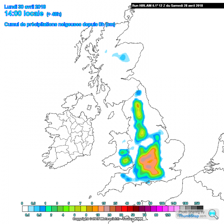
South Lincs and we are on the edge of a met office yellow warning covering the south east. However, netweather stating it'll just be windy with rain later in the day.
The models are still struggling to nail it. If you're east of the M1, then expect the worst of it. South Lincs and we are on the edge of a met office yellow warning covering the south east. However, netweather stating it'll just be windy with rain later in the day.
This weather system is not 'usual - a deepening low coming from the south, interacting with northerly winds is ummm, rare.
So models really struggled to get it right. Plus some apps might update quicker to show the new track of the system (as per my late post last night).
Bone dry here, but radar shows the rain holding a few miles away. Good news for dog walking!
So models really struggled to get it right. Plus some apps might update quicker to show the new track of the system (as per my late post last night).
Bone dry here, but radar shows the rain holding a few miles away. Good news for dog walking!
Gassing Station | The Lounge | Top of Page | What's New | My Stuff