European Road Trip April/May '16
Discussion


a17vts said:
London424 said:
Looking at your route I'd pop in to Pisa for lunch as you're so close. I did something similar (but going the opposite way to you) and it's not far out of the way and you can see everything you'd want in an hour and grab a decent Pizza.
Thanks for the advice London424. Zed 44 said:
Quite welcome a17vts. Yes, motogoloco is very good.
With respect to vignettes, I have been twice and didn't need one as I didn't use the autoroutes. It should be possible to plan your journey and avoid them.
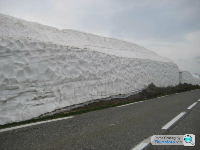
I think you did right to postpone your trip. You don't want any of this.
I'll be booking my crossings today/tonight, and then planning a rough route, which I believe will take most of my time and then book hotels up accordingly.With respect to vignettes, I have been twice and didn't need one as I didn't use the autoroutes. It should be possible to plan your journey and avoid them.
I think you did right to postpone your trip. You don't want any of this.
The main things which scares me is planning to many hours into a days driving. I plan on doing a long day on the first day as I've had to reduce the trip down by a day going in June, but with the passes I want to complete I need to really confirm these before booking the accommodation.
I should have more updates later today.
From memory I think I then planned an average of 150 - 200 miles a day. So you'd leave your hotel ~9 or 10 am, a few hours of driving and stopping etc, some lunch, then a few more hours to the next hotel.
If you're going with the other half whatever you do have a Sat Nav. You plug in where you want to go and then no arguments at all. If a road is closed you get re-routed or you choose something else.
a17vts said:
I'll be booking my crossings today/tonight, and then planning a rough route, which I believe will take most of my time and then book hotels up accordingly.
The main things which scares me is planning to many hours into a days driving. I plan on doing a long day on the first day as I've had to reduce the trip down by a day going in June, but with the passes I want to complete I need to really confirm these before booking the accommodation.
I should have more updates later today.
Good call on moving the trip!The main things which scares me is planning to many hours into a days driving. I plan on doing a long day on the first day as I've had to reduce the trip down by a day going in June, but with the passes I want to complete I need to really confirm these before booking the accommodation.
I should have more updates later today.
In terms of driving distance per day, I've found 200-230 miles is a good distance to aim for through the mountains, and 4-500 on mostly motorways. But this can get quite tiring every day for 10 days, so you may want to make sure you have a couple of shorter days during the trip or stopping for 2 nights as someone else has suggested.
With regard to using a satnav, I've found that this is usually quite frustrating as it will want to take you the fastest route, and away from the fun roads! I spent a few hours putting together a route book by planning the route on Google maps for each day, with basic directions and place names which I then printed out. I then just used the sat nav to make sure I was on the right track, and to find hotels at the end of the day.
It's also worth trying to plan your route so you avoid the more popular passes at busy times.
I did a similar driving trip last September - hopefully the write up will be of some use/interest!
http://www.stuffsandthings.co.uk/european-road-tri...
London424 said:
When I did it I did a big first day, from Calais down to Bern. A bit of a grind but I wanted to maximise my time in the fun stuff. The other reason was I figured I'd be at my freshest so just get it out the way.
From memory I think I then planned an average of 150 - 200 miles a day. So you'd leave your hotel ~9 or 10 am, a few hours of driving and stopping etc, some lunch, then a few more hours to the next hotel.
If you're going with the other half whatever you do have a Sat Nav. You plug in where you want to go and then no arguments at all. If a road is closed you get re-routed or you choose something else.
I thought the very same thing regarding a long first day. I'm thinking of going from Calais to Lake Garda in one hit, although will stop at Reims on route. Plus as it should be mainly easy driving the wife can do a few hours!From memory I think I then planned an average of 150 - 200 miles a day. So you'd leave your hotel ~9 or 10 am, a few hours of driving and stopping etc, some lunch, then a few more hours to the next hotel.
If you're going with the other half whatever you do have a Sat Nav. You plug in where you want to go and then no arguments at all. If a road is closed you get re-routed or you choose something else.
Regarding the satnav this is one thing I certainly want to have clear before I leave, firstly for the reason you mentioned about and secondly its just nice to drive without really thinking about where you have to go.
ehasler said:
Good call on moving the trip!
In terms of driving distance per day, I've found 200-230 miles is a good distance to aim for through the mountains, and 4-500 on mostly motorways. But this can get quite tiring every day for 10 days, so you may want to make sure you have a couple of shorter days during the trip or stopping for 2 nights as someone else has suggested.
With regard to using a satnav, I've found that this is usually quite frustrating as it will want to take you the fastest route, and away from the fun roads! I spent a few hours putting together a route book by planning the route on Google maps for each day, with basic directions and place names which I then printed out. I then just used the sat nav to make sure I was on the right track, and to find hotels at the end of the day.
It's also worth trying to plan your route so you avoid the more popular passes at busy times.
I did a similar driving trip last September - hopefully the write up will be of some use/interest!
http://www.stuffsandthings.co.uk/european-road-tri...
Thanks for the guidance regarding distant per day. As previously mentioned this is currently my main concern as I don't want to over egg distance but in the same breath I don't want to cut my holiday short and feel that I had spare time on my hands.In terms of driving distance per day, I've found 200-230 miles is a good distance to aim for through the mountains, and 4-500 on mostly motorways. But this can get quite tiring every day for 10 days, so you may want to make sure you have a couple of shorter days during the trip or stopping for 2 nights as someone else has suggested.
With regard to using a satnav, I've found that this is usually quite frustrating as it will want to take you the fastest route, and away from the fun roads! I spent a few hours putting together a route book by planning the route on Google maps for each day, with basic directions and place names which I then printed out. I then just used the sat nav to make sure I was on the right track, and to find hotels at the end of the day.
It's also worth trying to plan your route so you avoid the more popular passes at busy times.
I did a similar driving trip last September - hopefully the write up will be of some use/interest!
http://www.stuffsandthings.co.uk/european-road-tri...
I been linked by two separated PH member to www.motogoloco.com, on this website you can plot your route like google maps and then download the route to a TomTom device. I don't believe I can download these files to my VW system but for the sake of £80 or so I am happy to buy a TomTom to use for the trip, this way I should be able to go the exact route I wish without too much trouble.
Funnily enough I read your write up earlier this week and found it really interesting.
a17vts said:
I thought the very same thing regarding a long first day. I'm thinking of going from Calais to Lake Garda in one hit, although will stop at Reims on route. Plus as it should be mainly easy driving the wife can do a few hours!
Regarding the satnav this is one thing I certainly want to have clear before I leave, firstly for the reason you mentioned about and secondly its just nice to drive without really thinking about where you have to go.
I too should be going to lake garda that week or the week before. Looking forward to it, even if we will be staying round he lake for a few days, i can get some decent driving in there and back Regarding the satnav this is one thing I certainly want to have clear before I leave, firstly for the reason you mentioned about and secondly its just nice to drive without really thinking about where you have to go.

Ref the sat nav, if you want to do a proper itinery, current Tom Toms are useless. Get a Garmin and then you can do it. Tedious, but well worth it, so, as you say, you dont need to worry about map reading, arguing etc.
monkfish1 said:
I too should be going to lake garda that week or the week before. Looking forward to it, even if we will be staying round he lake for a few days, i can get some decent driving in there and back
Ref the sat nav, if you want to do a proper itinery, current Tom Toms are useless. Get a Garmin and then you can do it. Tedious, but well worth it, so, as you say, you dont need to worry about map reading, arguing etc.
You're not the only one to tell me that current TomToms are useless, Roastie ITR who had helped me out, as I'm pretty much copying his route sent me a number of ITN (think that the file name) files which I can use but need to see if I can open them first!Ref the sat nav, if you want to do a proper itinery, current Tom Toms are useless. Get a Garmin and then you can do it. Tedious, but well worth it, so, as you say, you dont need to worry about map reading, arguing etc.
Edited by a17vts on Friday 8th January 22:17
a17vts said:
Your not the only one to tell me that current TomToms are useless, Roastie ITR who had helped me out, as I'm pretty much copying his route sent me a number of ITN (think that the file name) files which I can use but need to see if I can open them first!
Sounds like a plan 
Not got as far as planning the route in detail yet myself. Covered a fair bit of ground last year in northern italy on the Club Triumph 10 countries run. Was defo the best bit
Motogoloco is definitely the best of the online route planners, but standalone programmes such as TYRE and ITNConverter are far better still.
If you have any interest in route planning at all you will want to be able to plan based on drag/drop waypoints (so as to pinpoint specific sections of road). As far as I can tell Motogoloco only allows you to input place names. TYRE and ITNConverter also use Google Maps as the base platform so you can use features like Street View.
If you have any interest in route planning at all you will want to be able to plan based on drag/drop waypoints (so as to pinpoint specific sections of road). As far as I can tell Motogoloco only allows you to input place names. TYRE and ITNConverter also use Google Maps as the base platform so you can use features like Street View.
plenty said:
Motogoloco is definitely the best of the online route planners, but standalone programmes such as TYRE and ITNConverter are far better still.
If you have any interest in route planning at all you will want to be able to plan based on drag/drop waypoints (so as to pinpoint specific sections of road). As far as I can tell Motogoloco only allows you to input place names.
Funnily enough I was just looking a TYRE and just read about ITNConverter there is so much to learn regarding routes, and to be honest I was under the impression I could plan my own route on Motogoloco but I only assumed.If you have any interest in route planning at all you will want to be able to plan based on drag/drop waypoints (so as to pinpoint specific sections of road). As far as I can tell Motogoloco only allows you to input place names.
I'll have a play around online tonight, but I don't want to spend time on a system which is effectively pointless but at the same time I want to find one I know will do the job required.
plenty said:
Motogoloco is definitely the best of the online route planners, but standalone programmes such as TYRE and ITNConverter are far better still.
If you have any interest in route planning at all you will want to be able to plan based on drag/drop waypoints (so as to pinpoint specific sections of road). As far as I can tell Motogoloco only allows you to input place names. TYRE and ITNConverter also use Google Maps as the base platform so you can use features like Street View.
Also just to confirm do you mean this website: http://www.tyretotravel.com ?If you have any interest in route planning at all you will want to be able to plan based on drag/drop waypoints (so as to pinpoint specific sections of road). As far as I can tell Motogoloco only allows you to input place names. TYRE and ITNConverter also use Google Maps as the base platform so you can use features like Street View.
Yep, TYRE is really easy and you can export routes in lots of formats.
TomTom stopped doing upload able route files for a few years but have just re-introduced it (bout bloody time).
Re distance, if you are just thumping down a motorway then 400-450 miles a day is fine, if you are on interesting roads then sub 300 or it becomes a grind.
I'll be off on my Eurojaunt around the same time so might give you a wave if I spot you ;-)
Jim
Happy Jim said:
Yep, TYRE is really easy and you can export routes in lots of formats.
TomTom stopped doing upload able route files for a few years but have just re-introduced it (bout bloody time).
Re distance, if you are just thumping down a motorway then 400-450 miles a day is fine, if you are on interesting roads then sub 300 or it becomes a grind.
I'll be off on my Eurojaunt around the same time so might give you a wave if I spot you ;-)
Jim
Thanks Jim.TomTom stopped doing upload able route files for a few years but have just re-introduced it (bout bloody time).
Re distance, if you are just thumping down a motorway then 400-450 miles a day is fine, if you are on interesting roads then sub 300 or it becomes a grind.
I'll be off on my Eurojaunt around the same time so might give you a wave if I spot you ;-)
Jim
Do you know if all new TomTom devices are capable of coping files from TYRE?
I've been looking at Argos and TomTom's start at around £80 but I can't seem to work out if they accept preloaded routes?
Tom
My 2016 trip was made on Motogoloco first then transferred to Google Maps. It is not necessary to transfer to Google Maps though. Transfer from Motogoloco to Tyre and then to TomTom (but it has to be an older model that will accept itn. files).
Incidentally, you can put in waypoints on Motogoloco by using the "via" box or you can simply "pull" the route by hovering the cursor over the route, clicking on the mouse to move it.
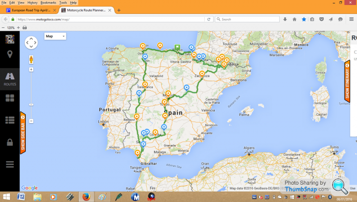
Another advantage of Motogoloco is that you can create your routes in layers, ie. by the day and then add the layers to make the final map. The map below was made up of 12 separate days.
Oh, and you can use pegman on both Google Maps and Tyre to get a street view.
Motogoloco
Googlemaps

Incidentally, you can put in waypoints on Motogoloco by using the "via" box or you can simply "pull" the route by hovering the cursor over the route, clicking on the mouse to move it.
Another advantage of Motogoloco is that you can create your routes in layers, ie. by the day and then add the layers to make the final map. The map below was made up of 12 separate days.
Oh, and you can use pegman on both Google Maps and Tyre to get a street view.
Motogoloco
Googlemaps
Edited by Zed 44 on Friday 8th January 23:25
a17vts said:
Do you know if all new TomTom devices are capable of coping files from TYRE?
I've been looking at Argos and TomTom's start at around £80 but I can't seem to work out if they accept preloaded routes?
None of the new TomTom devices you can buy can accept pre-loaded ITN files like older models. For reasons best known to TomTom a decision was made to cripple the itinerary-planning function around 2011 on all subsequent models so that waypoints no longer function.I've been looking at Argos and TomTom's start at around £80 but I can't seem to work out if they accept preloaded routes?
The following older units have the full itinerary-planning capability:
XL Classic
XL 20/30 Series
One IQ Routes Europe
XL IQ Routes Europe '09
XXL IQ Routes Europe '10
One XL Europe
GO 300/500/700
GO 510/710/910
GO 520/720/920
GO 530/730/930
GO 540/740/940
GO 550/750/950
Alternatively new Garmin devices are fully capable of accepting waypoints and in fact are superior in this respect to even the older TomTom devices (which are limited to 48 waypoints per ITN file).
plenty said:
None of the new TomTom devices you can buy can accept pre-loaded ITN files like older models. For reasons best known to TomTom a decision was made to cripple the itinerary-planning function around 2011 on all subsequent models so that waypoints no longer function.
The following older units have the full itinerary-planning capability:
XL Classic
XL 20/30 Series
One IQ Routes Europe
XL IQ Routes Europe '09
XXL IQ Routes Europe '10
One XL Europe
GO 300/500/700
GO 510/710/910
GO 520/720/920
GO 530/730/930
GO 540/740/940
GO 550/750/950
Alternatively new Garmin devices are fully capable of accepting waypoints and in fact are superior in this respect to even the older TomTom devices (which are limited to 48 waypoints per ITN file).
Thanks Plenty, thats really helpful. The following older units have the full itinerary-planning capability:
XL Classic
XL 20/30 Series
One IQ Routes Europe
XL IQ Routes Europe '09
XXL IQ Routes Europe '10
One XL Europe
GO 300/500/700
GO 510/710/910
GO 520/720/920
GO 530/730/930
GO 540/740/940
GO 550/750/950
Alternatively new Garmin devices are fully capable of accepting waypoints and in fact are superior in this respect to even the older TomTom devices (which are limited to 48 waypoints per ITN file).
I think I may have to go for the Garmin, although slightly more expensive than the equivalent TomTom, I need to buy a device that does what is required, at present it seems pointless as I currently have a built in satnav but I do hope on buying a kit car in the future so i guess it can be used in years to come.
Happy Jim said:
I have the TomTom Go6000 and in Nov they updated the firmware so that you can upload it inert files in GPX format. Works fine, no realistic limit to how many waypoints you have.
Jim
Thanks Jim.Jim
I'm down to down load TYRE tomorrow on my work PC tomorrow and finalise the route. I think I'm 75% complete I just need to ensure when I complete the routes in TYRE I'm hitting all the passes etc I wish to pass. Roastie ITR has sent me some ITN files which I believe I can open on TRYE so I'm hoping these will help me confirm my routes as I have pretty much copied his route.
UPDATED ITINERARY JUNE 2016
After spending the best part of this weekend on the internet researching hotels and routes, I believe I have pretty much completed the plan for our trip, the only area I do not feel 100% confident with is the actual routes I'll be driving but they will only be minor adjustments to ensure I hit the roads I'm looking for.
The 'tour' will commence on Thursday 16th June 2016 and the details are as follows:
Day 1 - Home to Lake Geneva
Day 2 - Lake Geneva to Avigliana (via Chamonix & Saint Bernard Pass)
Day 3 - Avigliana to Monte Carlo (via Col Du Turini)
Day 4 - Monte Carlo to Maranello
Day 5 - Maranello to Lake Como (via Lake Garda)
Day 6 - Rest day at Lake Como
Day 7 - Lake Como to Davos (via Stelvio & Fluela Pass)
Day 8 - Davos to Andermatt (via San Bernadino, Furka & Grimmsel Pass)
Day 9 - Andermatt to Baden-Baden
Day 10 - Baden-Baden to Luxembourg City
Day 11 - Luxembourg City to Home
I've added a rest day at Lake Como, which will break up the trip and make it feel a little more 'holiday' like!
We've agreed on all our hotels and I'm after this post I'll be confirming these along with the Euro Tunnel crossing. I've also worked out the costing, although I still need to add the tolls fees, road taxes and general food etc.
In summary the costs are as follows;
Euro Tunnel = £158.00
Hotels = £1,262.31
Diesel = £199.40 (based at current diesel prices and average consumption)
Total = £1,619.68
According to my calculations I'll be completing around 2,500 miles during the whole trip.
I'll keep you all posted.
Tom
Happy Jim said:
I have the TomTom Go6000 and in Nov they updated the firmware so that you can upload it inert files in GPX format. Works fine, no realistic limit to how many waypoints you have.
Jim
That's good news. I know a few people who stopped buying TomTom due to lack of waypoint support.Jim
Gassing Station | Roads | Top of Page | What's New | My Stuff