Discussion


So these are the three days I've penciled in for this coming May, obviously taken a lot from last year but added a few chunks in here and there. Criticisms welcome
Wales Day 1 2017
https://goo.gl/maps/wj66PCoxMf12
Wales Day 2 2017
https://goo.gl/maps/WbPbJyfKSZn
Wales Day 3 2017
https://goo.gl/maps/PtyG7KsbtaB2
Wales Day 1 2017
https://goo.gl/maps/wj66PCoxMf12
Wales Day 2 2017
https://goo.gl/maps/WbPbJyfKSZn
Wales Day 3 2017
https://goo.gl/maps/PtyG7KsbtaB2
Abergavenny to B is road works at the moment. Not sure when it is finished though last travelled that a few months ago (and swore never again until works completed).
Major stuff going on, lots of mini roundabouts for the site accesses in a valley and big wagons have to come to a near stop to navigate them.
Perhaps someone more recently travelled/local can comment?
Major stuff going on, lots of mini roundabouts for the site accesses in a valley and big wagons have to come to a near stop to navigate them.
Perhaps someone more recently travelled/local can comment?
Looks like roadworks are ongoing there for many many months well into next year. I can easily miss that out as only going to Ebbw Vale because I know there is a Morrisons for a cheap breakfast, food for lunch later and cheap petrol there. Can easily stop at Waitrose in Abergavenny for a slightly more expensive breaky and petrol stop instead.
Day 1.
Re this section of your route - https://goo.gl/maps/Wrd12zeQU1n
This sign in Welsh means unsuitable for motor vehicles - https://goo.gl/maps/TvURCwYaEDA2
The other end is by the Claerwen dam - https://goo.gl/maps/ggkoJN6wzKr
The distance between them is 8.5 miles of best Welsh '3 ply' - https://goo.gl/maps/LPvyUHdWyXp
There are also a couple of other obstacles to tackle...
https://goo.gl/maps/nrSQr21Sxat
https://goo.gl/maps/u27uZNotyBy
Have a look at this - https://www.youtube.com/watch?v=4gsoaP7xgAE&t=...
It will give you an idea of what you will be facing. As rough as a badger's a**e!
It's fun at full chat in a rally spec car which is built for the job.
But, unless you fancy demolishing your sump, you'll be driving like Miss Daisy...
The Claerwen dam has parking at the top and bottom.
A limited amount at the former.
https://goo.gl/maps/GkjjaEBm9kx
And much more at the latter.
https://goo.gl/maps/P4YpH53yNyK2
A group of us went on a fabulous warm and sunny day in February 2014.
The advantage of going at that time of year is the reservoirs are full.
So we had the benefit of water cascading down the spillways.
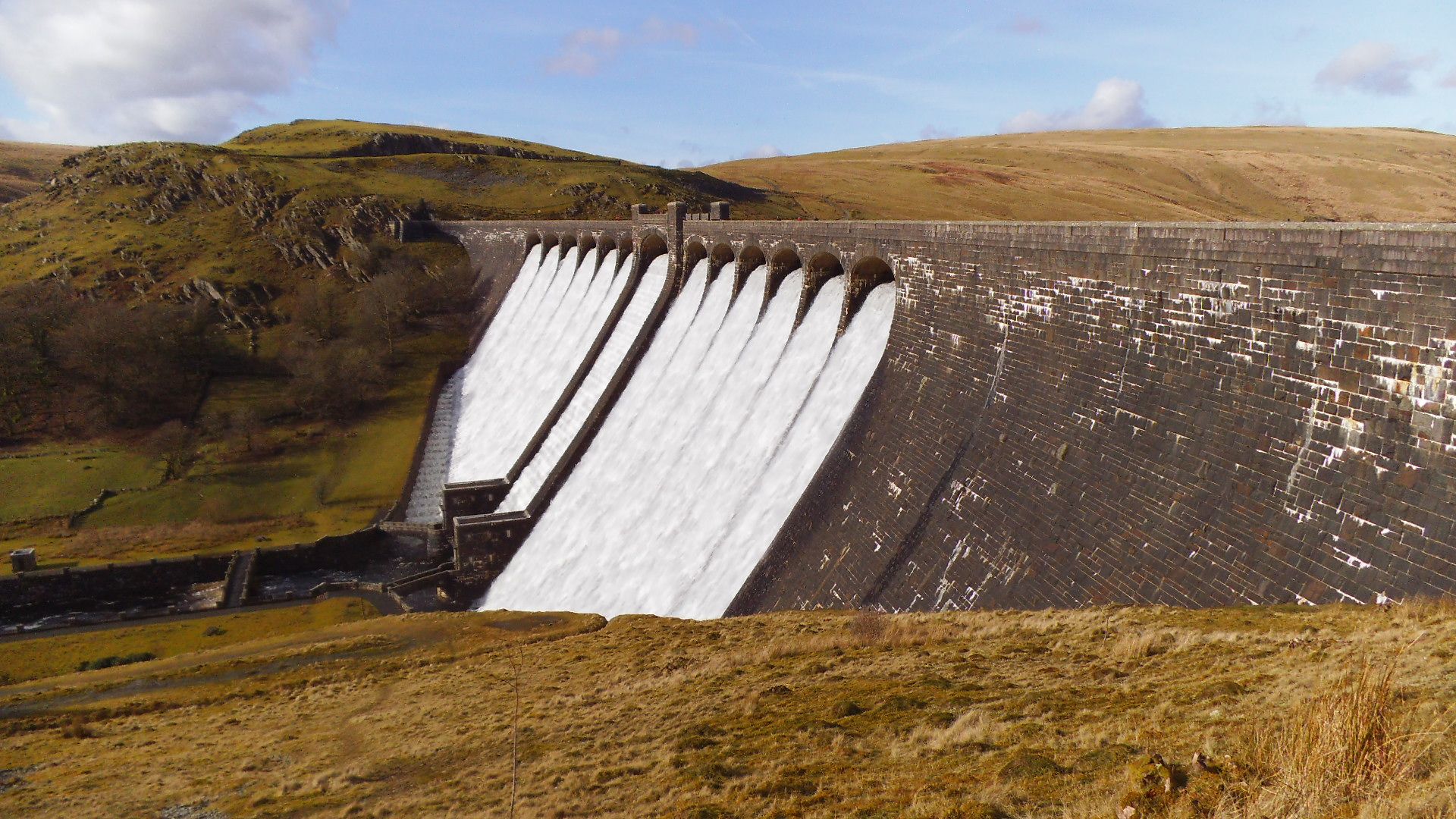
Arguably, in the right conditions, Caban Coch next to the Elan Visitor Centre is the most spectacular.
Day 2.
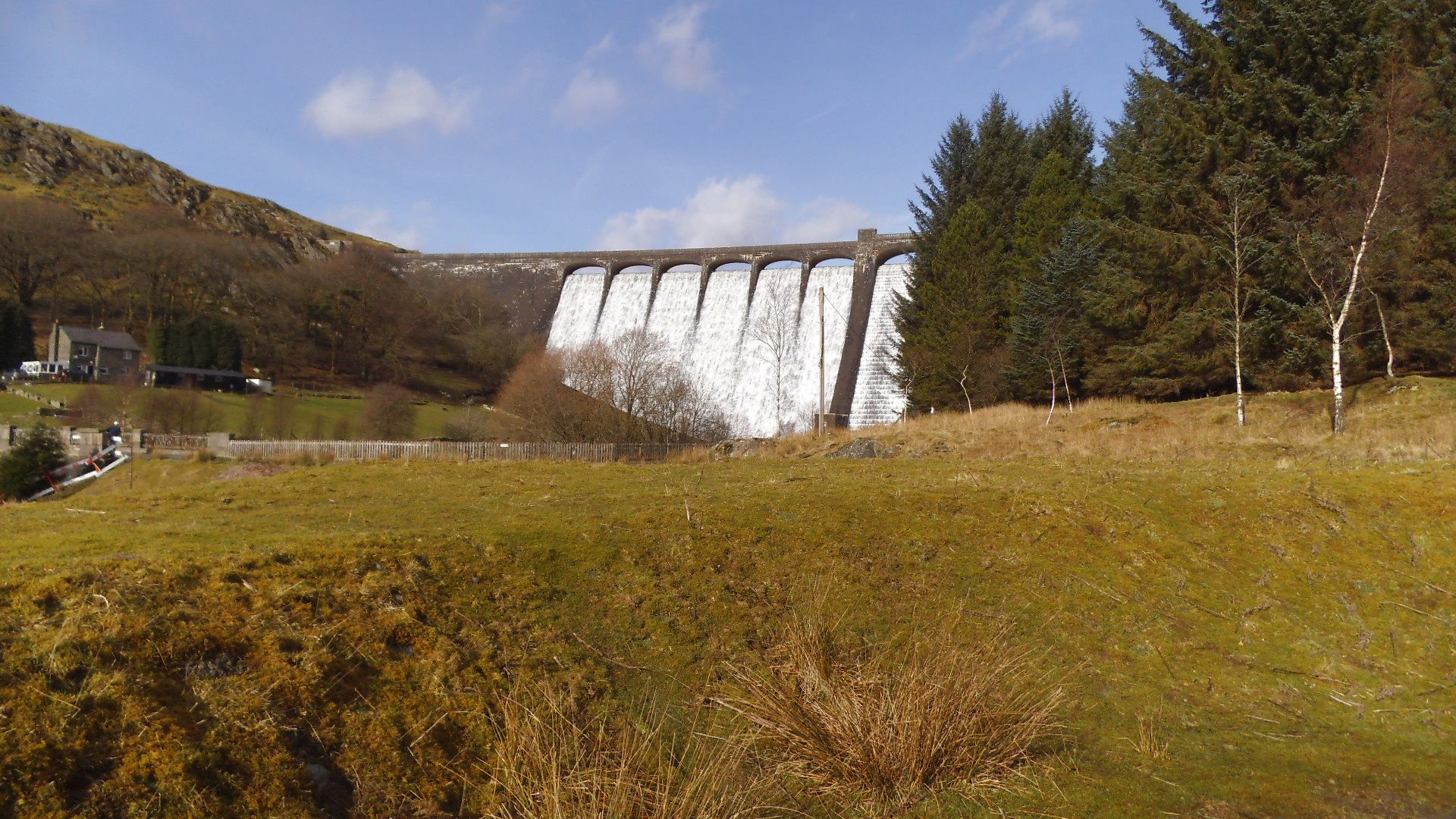
I would include this anti-clockwise loop of Llyn Clywedog.
https://goo.gl/maps/JVD49fqaMbC2
Turn off the B4518 here - https://goo.gl/maps/AMStfWbdMsK2
There is just enough space to park a couple of cars on both sides of this cattle grid.
https://goo.gl/maps/TLLPvuftvCu
Walk about 100yds down the hill for this spectacular view.
https://goo.gl/maps/6WFx9jUDrP22
You can get up close to the base of the dam by visiting the Bryntail Lead Mine.
The ruined buildings can be seen in the link above.
They can be reached by turning left here.
https://goo.gl/maps/zE3Bnfc7Son
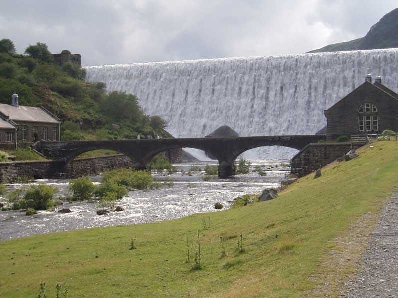
Park at the end and walk across the footbridge over the Afon Clywedog.
Re this section of your route - https://goo.gl/maps/Wrd12zeQU1n
This sign in Welsh means unsuitable for motor vehicles - https://goo.gl/maps/TvURCwYaEDA2
The other end is by the Claerwen dam - https://goo.gl/maps/ggkoJN6wzKr
The distance between them is 8.5 miles of best Welsh '3 ply' - https://goo.gl/maps/LPvyUHdWyXp
There are also a couple of other obstacles to tackle...
https://goo.gl/maps/nrSQr21Sxat
https://goo.gl/maps/u27uZNotyBy
Have a look at this - https://www.youtube.com/watch?v=4gsoaP7xgAE&t=...
It will give you an idea of what you will be facing. As rough as a badger's a**e!
It's fun at full chat in a rally spec car which is built for the job.
But, unless you fancy demolishing your sump, you'll be driving like Miss Daisy...
The Claerwen dam has parking at the top and bottom.
A limited amount at the former.
https://goo.gl/maps/GkjjaEBm9kx
And much more at the latter.
https://goo.gl/maps/P4YpH53yNyK2
A group of us went on a fabulous warm and sunny day in February 2014.
The advantage of going at that time of year is the reservoirs are full.
So we had the benefit of water cascading down the spillways.
Arguably, in the right conditions, Caban Coch next to the Elan Visitor Centre is the most spectacular.
Day 2.
I would include this anti-clockwise loop of Llyn Clywedog.
https://goo.gl/maps/JVD49fqaMbC2
Turn off the B4518 here - https://goo.gl/maps/AMStfWbdMsK2
There is just enough space to park a couple of cars on both sides of this cattle grid.
https://goo.gl/maps/TLLPvuftvCu
Walk about 100yds down the hill for this spectacular view.
https://goo.gl/maps/6WFx9jUDrP22
You can get up close to the base of the dam by visiting the Bryntail Lead Mine.
The ruined buildings can be seen in the link above.
They can be reached by turning left here.
https://goo.gl/maps/zE3Bnfc7Son
Park at the end and walk across the footbridge over the Afon Clywedog.
Edited by Red Devil on Friday 10th March 12:43
Red Devil said:
The Claerwen dam has parking at the top and bottom.
A limited amount at the former.
https://goo.gl/maps/GkjjaEBm9kx
And much more at the latter.
https://goo.gl/maps/P4YpH53yNyK2
A group of us went on a fabulous warm and sunny day in February 2014.
The advantage of going at that time of year is the reservoirs are full.
So we had the benefit of water cascading down the spillways.
Take a sturdy length of rope and a decent winch with you and you can have ALL kinds of fun at the Claerwen dam ...A limited amount at the former.
https://goo.gl/maps/GkjjaEBm9kx
And much more at the latter.
https://goo.gl/maps/P4YpH53yNyK2
A group of us went on a fabulous warm and sunny day in February 2014.
The advantage of going at that time of year is the reservoirs are full.
So we had the benefit of water cascading down the spillways.
https://www.youtube.com/watch?v=7TZTa2tgJTs

Slippydiff said:
Take a sturdy length of rope and a decent winch with you and you can have ALL kinds of fun at the Claerwen dam ...
https://www.youtube.com/watch?v=7TZTa2tgJTs
That was inspired by the Land Rover TV ad. The difference being that in the ad the winch was installed in a false structure on the top of the dam.https://www.youtube.com/watch?v=7TZTa2tgJTs
Thus the LR was hauled up rather than actually pulling itself using the one mounted on the vehicle. Clywedog is 52 feet taller than Claerwen.
The story of the commercial's production can be read here - http://www.anatomised.com/is-this-the-best-ever-de...
The driver was Roy Alon and, with all the takes needed, he went up the dam 6 (and back down again 5) times compared to Hammond's one.
Roy Alon said:
"It's not trick photography. I had to drive the Land Rover all the way from the bottom to the top. My only problen was reversing down again for the next shot. It was so steep I couldn't turn round to look out of the rear window. It's certainly tall, the angle is something like 60 degrees but no tricks were used. It's a spectacular stunt."
To be fair to Hammond though, Roy was a professional stuntman. - http://www.gonetoosoon.org/memorials/roy-alonRed Devil said:
Slippydiff said:
Take a sturdy length of rope and a decent winch with you and you can have ALL kinds of fun at the Claerwen dam ...
https://www.youtube.com/watch?v=7TZTa2tgJTs
That was inspired by the Land Rover TV ad. The difference being that in the ad the winch was installed in a false structure on the top of the dam.https://www.youtube.com/watch?v=7TZTa2tgJTs
Thus the LR was hauled up rather than actually pulling itself using the one mounted on the vehicle. Clywedog is 52 feet taller than Claerwen.
The story of the commercial's production can be read here - http://www.anatomised.com/is-this-the-best-ever-de...
The driver was Roy Alon and, with all the takes needed, he went up the dam 6 (and back down again 5) times compared to Hammond's one.
Roy Alon said:
"It's not trick photography. I had to drive the Land Rover all the way from the bottom to the top. My only problen was reversing down again for the next shot. It was so steep I couldn't turn round to look out of the rear window. It's certainly tall, the angle is something like 60 degrees but no tricks were used. It's a spectacular stunt."
To be fair to Hammond though, Roy was a professional stuntman. - http://www.gonetoosoon.org/memorials/roy-alon
Slippydiff said:
Two excellent Welsh hoons, and unfortunately on both occasions you've missed the best road out of Bala 
I think you might be looking at last year's trip, I started this thread last year. This year is 3 days and I've a feeling day 2 has the road you're thinking about included although if I'm wrong I'll gladly be corrected. SmilerFTM said:
I think you might be looking at last year's trip, I started this thread last year. This year is 3 days and I've a feeling day 2 has the road you're thinking about included although if I'm wrong I'll gladly be corrected.
Was well aware that this piece had been maturing nicely in the barrel for a year now I'm posting from an iphone currently, but looking at both your routes yesterday on my desktop, indicated you'd missed a trick twice (and the mother of all sections of road in the process)
I'll double check once I'm back home and update accordingly (possibly by way of a PM).
Slippydiff said:
Was well aware that this piece had been maturing nicely in the barrel for a year now
I'm posting from an iphone currently, but looking at both your routes yesterday on my desktop, indicated you'd missed a trick twice (and the mother of all sections of road in the process)
I'll double check once I'm back home and update accordingly (possibly by way of a PM).
Cool thanksI'm posting from an iphone currently, but looking at both your routes yesterday on my desktop, indicated you'd missed a trick twice (and the mother of all sections of road in the process)
I'll double check once I'm back home and update accordingly (possibly by way of a PM).
SmilerFTM said:
So these are the three days I've penciled in for this coming May, obviously taken a lot from last year but added a few chunks in here and there. Criticisms welcome
Wales Day 1 2017
https://goo.gl/maps/wj66PCoxMf12
Wales Day 2 2017
https://goo.gl/maps/WbPbJyfKSZn
Wales Day 3 2017
https://goo.gl/maps/PtyG7KsbtaB2
Any improvements on these 3 days from the locals????Wales Day 1 2017
https://goo.gl/maps/wj66PCoxMf12
Wales Day 2 2017
https://goo.gl/maps/WbPbJyfKSZn
Wales Day 3 2017
https://goo.gl/maps/PtyG7KsbtaB2
Probably gonna run them in reverse, so starting North and heading south?
South to North is probably slightly better due to the views you get when running the A4069 on day 1, the unmarked road between the B4518 and Machynlleth on day 2 and the Llanberis Pass on day 3. The drive down to Lake Vyrnwy is also good fun going downhill which is done both day 2 and 3. You've also got a slightly shorter drive home when you've finished if Milton Keynes is still where you live although I imagine it depends exactly where you start and finish as there is little in it.
SmilerFTM said:
South to North is probably slightly better due to the views you get when running the A4069 on day 1, the unmarked road between the B4518 and Machynlleth on day 2 and the Llanberis Pass on day 3. The drive down to Lake Vyrnwy? is also good fun going downhill which is done both day 2 and 3. You've also got a slightly shorter drive home when you've finished if Milton Keynes is still where you live although I imagine it depends exactly where you start and finish as there is little in it.
Yeah still MK. Found a Top gear route that takes in loads so will map it all out and have a look!ETA:
https://goo.gl/maps/p2rfTtnREA92
https://goo.gl/maps/Qf6MkbUXfLU2
https://goo.gl/maps/PkFmEnkT67w
https://goo.gl/maps/ac9yoh5yqgv
https://goo.gl/maps/wQ7PmhHT5692
Edited by JB! on Wednesday 29th March 15:37
JB! said:
Yeah still MK. Found a Top gear route that takes in loads so will map it all out and have a look!
ETA:
https://goo.gl/maps/p2rfTtnREA92
https://goo.gl/maps/Qf6MkbUXfLU2
https://goo.gl/maps/PkFmEnkT67w
https://goo.gl/maps/ac9yoh5yqgv
https://goo.gl/maps/wQ7PmhHT5692
Fixed that last day for you ETA:
https://goo.gl/maps/p2rfTtnREA92
https://goo.gl/maps/Qf6MkbUXfLU2
https://goo.gl/maps/PkFmEnkT67w
https://goo.gl/maps/ac9yoh5yqgv
https://goo.gl/maps/wQ7PmhHT5692
Edited by JB! on Wednesday 29th March 15:37

Gassing Station | Roads | Top of Page | What's New | My Stuff