New DJI Mavic Mini
Discussion


Hoddo said:
Is there a reliable online resource to see restrictions or is the NATs Drone Assist App the best option?
One question about the NATs Drone Assist App, when it is a pink or very transparent red is that restricted air space or a recommendation to be very vigilant? Example being Manchester Airport, obviously very clear restriction around the airport and flight paths; however, there is a significant space surrounding the airport right down into Cheshire which shows this pink / light red colouring.
Just tap it for the full details:One question about the NATs Drone Assist App, when it is a pink or very transparent red is that restricted air space or a recommendation to be very vigilant? Example being Manchester Airport, obviously very clear restriction around the airport and flight paths; however, there is a significant space surrounding the airport right down into Cheshire which shows this pink / light red colouring.
Hoddo said:
Thank you
NP, personally I would avoid Class A, D and G airspace. On the right of the map if you deselect the top 4 options then click the blue "airspace details" and click the top option of "show default airspace" you will see the main areas.Then of course you are not permitted inside the 5km runway exclusion zones or any restricted areas.
You basically need to use the combination of drone safe website and NOTAM website IMHO.
red_slr said:
NP, personally I would avoid Class A, D and G airspace. On the right of the map if you deselect the top 4 options then click the blue "airspace details" and click the top option of "show default airspace" you will see the main areas.
Then of course you are not permitted inside the 5km runway exclusion zones or any restricted areas.
You basically need to use the combination of drone safe website and NOTAM website IMHO.
Class G is uncontrolled airspace and likely the best place to be flying a drone surely?Then of course you are not permitted inside the 5km runway exclusion zones or any restricted areas.
You basically need to use the combination of drone safe website and NOTAM website IMHO.
Sorry should have put more detail in, was doing 10 things at once.
So A - TMAs etc, D - Control areas, G Mil ATZ etc.
Basically anything on NOTAM website that is not a white area is what I (personally) would avoid.
I am far from an expert in this stuff though. I appreciate there are some large areas which are for example class A airspace but if you drill down they are often >5500 etc so they are white rather than red / pink.
ecsrobin said:
Class G is uncontrolled airspace and likely the best place to be flying a drone surely?
I would agree, but bear in mind Class G is also where you’ll most likely find private pilots in everything ranging from paramotor to microlights to standard Group A aircraft like Cessnas all bimbling around and only being required to stay 500ft from (not necessarily above) any one. Obviously big sky / small aircraft helps tilt the odds against any bumps.renmure said:
ecsrobin said:
Class G is uncontrolled airspace and likely the best place to be flying a drone surely?
I would agree, but bear in mind Class G is also where you’ll most likely find private pilots in everything ranging from paramotor to microlights to standard Group A aircraft like Cessnas all bimbling around and only being required to stay 500ft from (not necessarily above) any one. Obviously big sky / small aircraft helps tilt the odds against any bumps.Please help continue to educate a soon to be owner of a Mavic Mini.
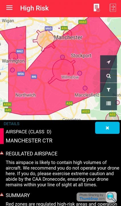
Manchester has its own restricted airspace directly over the airport which can be seen in the dark pink circle around the airport (see image below). I am also aware airports have a 1km wide and 5km long restriction around runways. What is the larger pink area, it is called 'Manchester TMA-1' on the NOTAM site? How do the restrictions directly around the airport (I.E. do not fly) differ from TMA-1?
On the Drone Assist app it calls that same area 'Manchester CTR' and states:
This airspace is likely to contain high volumes of aircraft. We recommend you do not operate your done here. If you do, please exercise extreme caution and abide by the CAA Dronecode, ensuring your drone remains within your line of site
This leads me to think you can operate your drone in TMA-1 / Manchester CTR as long as you're flying below 400ft and has line of site to the drone. Correct?
Appreciate the patience, I want to fly legally but understanding this stuff for a lay person is not easy.
There’s a bit more to it than that. The control zone around an airfield is bigger than you stated:
“Flights of unmanned aircraft around airfields or airports that are designated as ‘protected aerodromes’ are tightly restricted. Unmanned aircraft of any size must not be flown within the Flight Restriction Zone (FRZ) of a protected aerodrome, without appropriate permission.
The Flight Restriction Zone consists of the following three elements:
- The Aerodrome Traffic Zone: A 2 or 2.5 nautical mile radius ‘cylinder’ around the aerodrome, extending 2000 ft above ground level, centred on the longest runway.
- Runway Protection Zones: A rectangle extending 5Km from the threshold of the runway away from the aerodrome, along the extended runway centreline, and 500m either side- also to a height of 2000 ft above ground level.
- Additional Zones: In the case where the 1Km boundary of an aerodrome extends beyond the Aerodrome traffic zone, and so would not be protected by it, the flight restriction zone will include a ‘bump’ (the airfield boundary + 1KM) to protect this part of the aerodrome.”
The TMA won’t effect you as it starts at 3500ft flying within the CTR is allowed but exercise caution so hear an aircraft bring it down or to a low hover don’t go out of line of site and so on.
ecsrobin said:
There’s a bit more to it than that. The control zone around an airfield is bigger than you stated:
“Flights of unmanned aircraft around airfields or airports that are designated as ‘protected aerodromes’ are tightly restricted. Unmanned aircraft of any size must not be flown within the Flight Restriction Zone (FRZ) of a protected aerodrome, without appropriate permission.
The Flight Restriction Zone consists of the following three elements:
- The Aerodrome Traffic Zone: A 2 or 2.5 nautical mile radius ‘cylinder’ around the aerodrome, extending 2000 ft above ground level, centred on the longest runway.
- Runway Protection Zones: A rectangle extending 5Km from the threshold of the runway away from the aerodrome, along the extended runway centreline, and 500m either side- also to a height of 2000 ft above ground level.
- Additional Zones: In the case where the 1Km boundary of an aerodrome extends beyond the Aerodrome traffic zone, and so would not be protected by it, the flight restriction zone will include a ‘bump’ (the airfield boundary + 1KM) to protect this part of the aerodrome.”
The TMA won’t effect you as it starts at 3500ft flying within the CTR is allowed but exercise caution so hear an aircraft bring it down or to a low hover don’t go out of line of site and so on.
Superbly helpful, much obliged ecsrobin. This is clear and helps me a great deal.“Flights of unmanned aircraft around airfields or airports that are designated as ‘protected aerodromes’ are tightly restricted. Unmanned aircraft of any size must not be flown within the Flight Restriction Zone (FRZ) of a protected aerodrome, without appropriate permission.
The Flight Restriction Zone consists of the following three elements:
- The Aerodrome Traffic Zone: A 2 or 2.5 nautical mile radius ‘cylinder’ around the aerodrome, extending 2000 ft above ground level, centred on the longest runway.
- Runway Protection Zones: A rectangle extending 5Km from the threshold of the runway away from the aerodrome, along the extended runway centreline, and 500m either side- also to a height of 2000 ft above ground level.
- Additional Zones: In the case where the 1Km boundary of an aerodrome extends beyond the Aerodrome traffic zone, and so would not be protected by it, the flight restriction zone will include a ‘bump’ (the airfield boundary + 1KM) to protect this part of the aerodrome.”
The TMA won’t effect you as it starts at 3500ft flying within the CTR is allowed but exercise caution so hear an aircraft bring it down or to a low hover don’t go out of line of site and so on.
Hoddo said:
Please help continue to educate a soon to be owner of a Mavic Mini.
Not sure if it helps or not, but this is a snapshot from the CAA maps around the Manchester area and shows a line running North / South and shows that a top-down view of the airspace would make you think that there was no place to fly a drone. However as you can see from the bottom profile, when you see the airspace in 3d then there's large areas where you can comfortably fly under lots of the Class A and Class D airspace. It does get a bit confusing at times. 
dxg said:
Any idea why most of the Highlands are a restricted area on weekdays?
Because the RAF like to fly their jets there at 100ft. Again you can fly your drone there but it’s advisable to exercise extreme caution or check the timings: https://www.gov.uk/government/publications/operati...renmure said:
Hoddo said:
Please help continue to educate a soon to be owner of a Mavic Mini.
Not sure if it helps or not, but this is a snapshot from the CAA maps around the Manchester area and shows a line running North / South and shows that a top-down view of the airspace would make you think that there was no place to fly a drone. However as you can see from the bottom profile, when you see the airspace in 3d then there's large areas where you can comfortably fly under lots of the Class A and Class D airspace. It does get a bit confusing at times. Hoddo said:
Super interesting. Could you share a link to this, I dig some digging but could not find the map you shared.
It’s a screenshot of the flight planning software I use for general aviation flying. The top part of the pic is simply the official CAA chart and the planning and navigation software allows you to take a 3D view of the airspace. In GA there’s lots of times when trying to fly from A to B you can choose whether to go round, under, over or through various classes of airspace so thinking of it in 3D helps.If you’re interested you can probably download a free trial version of Skydemon which is a great navigation tool and will let you do what I did above and simply look at the airspace in a similar way once you put in a trial route. It’s fairly idiot proof

https://www.skydemon.aero/
renmure said:
It’s a screenshot of the flight planning software I use for general aviation flying. The top part of the pic is simply the official CAA chart and the planning and navigation software allows you to take a 3D view of the airspace. In GA there’s lots of times when trying to fly from A to B you can choose whether to go round, under, over or through various classes of airspace so thinking of it in 3D helps.
If you’re interested you can probably download a free trial version of Skydemon which is a great navigation tool and will let you do what I did above and simply look at the airspace in a similar way once you put in a trial route. It’s fairly idiot proof
https://www.skydemon.aero/
Great, thank you. The 3D image has helped a great deal as this shows that the area where I live (Northwich, Cheshire) has a restriction which does not kick in till 3,500ft; therefore, loads of scope for the drone. PhewIf you’re interested you can probably download a free trial version of Skydemon which is a great navigation tool and will let you do what I did above and simply look at the airspace in a similar way once you put in a trial route. It’s fairly idiot proof
https://www.skydemon.aero/
Gassing Station | Computers, Gadgets & Stuff | Top of Page | What's New | My Stuff