WW2 Photo-recon Maps. Possible Locations?
Discussion


Here are a couple of photos of somewhere in the Far East. Got loads more in sequences / stereo pairs.
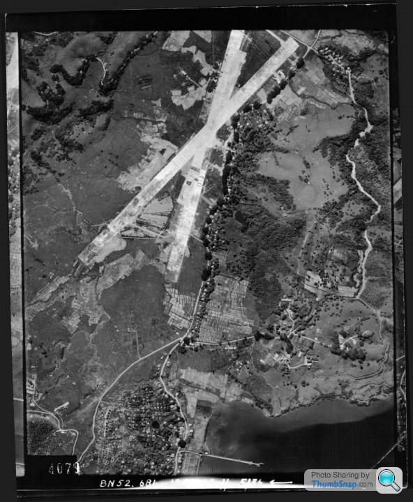
The airstrip is dated 12th Dec 1943, and the number 684. Presumably 684 Squadron. Found this on Google
http://www.historyofwar.org/articles/battles_mosqu...
"On 29 September 1943 No. 684 Squadron was formed around a nucleus from No. 681. PR Mosquitoes were soon ranging over Burma, Malaya and Thailand. The Mosquito had the speed and rate of climb to escape interception by Japanese fighters, and the endurance to make round trips of over 2,000 miles."
Looks like some Japanese aircraft, single and twin engined down there. I'd love to know where it is. How do I find out?

The river photos are dated 12th December 1942, and 3PRU, presumably this one:
"At the start of 1943 No.681 squadron had been formed from No. 3 PRU. It was equipped with Spitfires and Hurricanes for short distance work, and the B-25 Mitchell for longer distance work. Although the Mosquito had the range required, there were fears that the wood and glue construction would not be suitable for use in the heat and humidity of India and Burma. The Mosquito would indeed suffer from many problems as a bomber in this theatre. However, initial experience with a small number of Mosquitoes from August 1943 showed that the aircraft could safely operate in the area."
Same again - where is it? How do I find out?

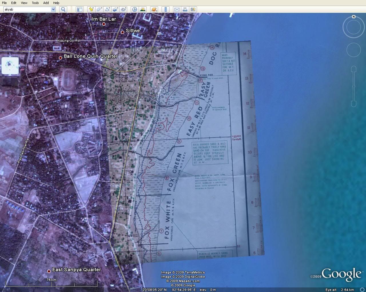
Finally a section of another map my Grandad must have drawn or at least been involved with. Anyone know where it is? I'm pretty sure it's an original D-Day map of Omaha beach. Maybe a preliminary version. Love the refernces to 'Mangrove'. All the village names and road names are made up, and far-eastern sounding.
Cheers for any help with this.

The airstrip is dated 12th Dec 1943, and the number 684. Presumably 684 Squadron. Found this on Google
http://www.historyofwar.org/articles/battles_mosqu...
"On 29 September 1943 No. 684 Squadron was formed around a nucleus from No. 681. PR Mosquitoes were soon ranging over Burma, Malaya and Thailand. The Mosquito had the speed and rate of climb to escape interception by Japanese fighters, and the endurance to make round trips of over 2,000 miles."
Looks like some Japanese aircraft, single and twin engined down there. I'd love to know where it is. How do I find out?

The river photos are dated 12th December 1942, and 3PRU, presumably this one:
"At the start of 1943 No.681 squadron had been formed from No. 3 PRU. It was equipped with Spitfires and Hurricanes for short distance work, and the B-25 Mitchell for longer distance work. Although the Mosquito had the range required, there were fears that the wood and glue construction would not be suitable for use in the heat and humidity of India and Burma. The Mosquito would indeed suffer from many problems as a bomber in this theatre. However, initial experience with a small number of Mosquitoes from August 1943 showed that the aircraft could safely operate in the area."
Same again - where is it? How do I find out?

Finally a section of another map my Grandad must have drawn or at least been involved with. Anyone know where it is? I'm pretty sure it's an original D-Day map of Omaha beach. Maybe a preliminary version. Love the refernces to 'Mangrove'. All the village names and road names are made up, and far-eastern sounding.
Cheers for any help with this.
The map is of the east sector of Omaha beach, near to Colleville-sur-Mer.
google map
google map
Edited by tank slapper on Wednesday 29th July 23:44
tank slapper said:
The map is of the east sector of Omaha beach, near to Colleville-sur-Mer.
google map
I'm sure you're right, but I can't see any features like the stream/river on Google Earth. I think I can see the roads there. I'll look at the rest of the map when I get home. Maybe some things were added on preliminary maps?google map
Edited by tank slapper on Wednesday 29th July 23:44
Thanks for that,
tank slapper said:
Thanks for the links. On my map there is a straight road 'Main Road' running behind the beach, but some distance back. It's not there on Google Earth. Maybe it's been added to confuse people.That's one hell of a cemetry down there...
Cheers,
I have been playing with your map in google earth and am no longer convinced that it does relate to that area. There are several things that I can't match up - firstly, the names of the landing areas are not exactly the same, the end most one marked Fox White on your map, was actually Fox Green at Omaha.
I can't make the coastline match up to that area, or anywhere along the landing beaches. There is a stream or river in a similar location, but the adjacent coastline doesn't fit. There is a road that is almost completely straight running parallel to the shore, of which there is no sign on other maps.
The orientation is also different - it would suggest that the coastline is north/south. Pretty much all other maps I have been looking at of Omaha beach are oriented either as though looking towards the beach, or with north up.
It may relate to another allied landing, but I don't know which others used similar divisions along the length of the beach.
Edited by tank slapper on Thursday 30th July 13:04
tank slapper said:
I have been playing with your map in google earth and am no longer convinced that it does relate to that area. There are several things that I can't match up - firstly, the names of the landing areas are not exactly the same, the end most one marked Fox White on your map, was actually Fox Green at Omaha.
I can't make the coastline match up to that area, or anywhere along the landing beaches. There is a stream or river in a similar location, but the adjacent coastline doesn't fit. There is a road that is almost completely straight running parallel to the shore, of which there is no sign on other maps.
The orientation is also different - it would suggest that the coastline is north/south. Pretty much all other maps I have been looking at of Omaha beach are oriented either as though looking towards the beach, or with north up.
It may relate to another allied landing, but I don't know which others used similar divisions along the length of the beach.
Hmmm I'll look at the rest of the map tonight - I could only scan an A4 section, it is an A1 Map.I can't make the coastline match up to that area, or anywhere along the landing beaches. There is a stream or river in a similar location, but the adjacent coastline doesn't fit. There is a road that is almost completely straight running parallel to the shore, of which there is no sign on other maps.
The orientation is also different - it would suggest that the coastline is north/south. Pretty much all other maps I have been looking at of Omaha beach are oriented either as though looking towards the beach, or with north up.
It may relate to another allied landing, but I don't know which others used similar divisions along the length of the beach.
Edited by tank slapper on Thursday 30th July 13:04
I'm convinced I saw an almost identical copy of the map in a Sunday Times supplement on D-Day. Up untill I saw that, I'd assumed it was in the Far East somewhere (like the photographs I have). As I said, all the place names are foreign sounding.
Cheers,
Hi everyone. World war II in Burma/India is of particular interest and I'm currently researching RAF 3 PRU and 681 Sqn. What a surprise when I finished up here earlier today - thanks to Google.
'dr_gn' you are spot on with the photos and map having something to do with Far East.
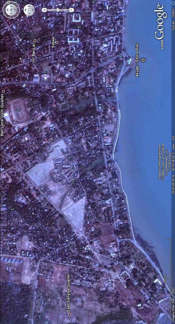
The map is actually of Akyab town [nowdays Sittwe] which is on the west bank of the Kaladan River which flows into the Bay of Bengal on the west coast of Burma in Rakhine [Rakhaing] State. Coords 20°08'N 92°54'E will get you there on Google Earth.
I've enclosed a Google image of the area and the "Stone Pier" which appears at the top of map, I've marked on the image as a reference point. You can easily see the small river/creek running inland below the stone pier.
The buildings probably wont make a lot sense, bearing in mind that during the war Akyab was just a small coastal town, nowdays much larger with something like 1/4 million population. River bank alignments may well have changed over the years due monsoon flooding.
I think the map is to do with "Operation Talon" which was planned in late 1944 to capture and free Akyab from the Japanese by early 1945. Sea/river landings were to be part of the operation which never went ahead as the Japanese withdrew from the area.
'dr_gn' is it possible to post a full size of the map?
The river photos could be one of any number of rivers. Please post some more and I'll have a go at indentifying them. Likewise the airfield, any other photos, maybe different angles?
Looking forward to further input into this most interest topic.
regards airlana
'dr_gn' you are spot on with the photos and map having something to do with Far East.
The map is actually of Akyab town [nowdays Sittwe] which is on the west bank of the Kaladan River which flows into the Bay of Bengal on the west coast of Burma in Rakhine [Rakhaing] State. Coords 20°08'N 92°54'E will get you there on Google Earth.
I've enclosed a Google image of the area and the "Stone Pier" which appears at the top of map, I've marked on the image as a reference point. You can easily see the small river/creek running inland below the stone pier.
The buildings probably wont make a lot sense, bearing in mind that during the war Akyab was just a small coastal town, nowdays much larger with something like 1/4 million population. River bank alignments may well have changed over the years due monsoon flooding.
I think the map is to do with "Operation Talon" which was planned in late 1944 to capture and free Akyab from the Japanese by early 1945. Sea/river landings were to be part of the operation which never went ahead as the Japanese withdrew from the area.
'dr_gn' is it possible to post a full size of the map?
The river photos could be one of any number of rivers. Please post some more and I'll have a go at indentifying them. Likewise the airfield, any other photos, maybe different angles?
Looking forward to further input into this most interest topic.
regards airlana
airlana said:
Hi everyone. World war II in Burma/India is of particular interest and I'm currently researching RAF 3 PRU and 681 Sqn. What a surprise when I finished up here earlier today - thanks to Google.
'dr_gn' you are spot on with the photos and map having something to do with Far East.
The map is actually of Akyab town [nowdays Sittwe] which is on the west bank of the Kaladan River which flows into the Bay of Bengal on the west coast of Burma in Rakhine [Rakhaing] State. Coords 20°08'N 92°54'E will get you there on Google Earth.
I've enclosed a Google image of the area and the "Stone Pier" which appears at the top of map, I've marked on the image as a reference point. You can easily see the small river/creek running inland below the stone pier.
The buildings probably wont make a lot sense, bearing in mind that during the war Akyab was just a small coastal town, nowdays much larger with something like 1/4 million population. River bank alignments may well have changed over the years due monsoon flooding.
I think the map is to do with "Operation Talon" which was planned in late 1944 to capture and free Akyab from the Japanese by early 1945. Sea/river landings were to be part of the operation which never went ahead as the Japanese withdrew from the area.
'dr_gn' is it possible to post a full size of the map?
The river photos could be one of any number of rivers. Please post some more and I'll have a go at indentifying them. Likewise the airfield, any other photos, maybe different angles?
Looking forward to further input into this most interest topic.
regards airlana
Chuffing Hell.'dr_gn' you are spot on with the photos and map having something to do with Far East.
The map is actually of Akyab town [nowdays Sittwe] which is on the west bank of the Kaladan River which flows into the Bay of Bengal on the west coast of Burma in Rakhine [Rakhaing] State. Coords 20°08'N 92°54'E will get you there on Google Earth.
I've enclosed a Google image of the area and the "Stone Pier" which appears at the top of map, I've marked on the image as a reference point. You can easily see the small river/creek running inland below the stone pier.
The buildings probably wont make a lot sense, bearing in mind that during the war Akyab was just a small coastal town, nowdays much larger with something like 1/4 million population. River bank alignments may well have changed over the years due monsoon flooding.
I think the map is to do with "Operation Talon" which was planned in late 1944 to capture and free Akyab from the Japanese by early 1945. Sea/river landings were to be part of the operation which never went ahead as the Japanese withdrew from the area.
'dr_gn' is it possible to post a full size of the map?
The river photos could be one of any number of rivers. Please post some more and I'll have a go at indentifying them. Likewise the airfield, any other photos, maybe different angles?
Looking forward to further input into this most interest topic.
regards airlana
More than impressed - Thank you so much! I'll look at the others tonight.
Forgot to mention that on your map at top left there is "MAYU ROAD".
No doubt named after the Mayu River, which if you look on Google Earth, there are two large rivers which join together where they flow into the ocean, about 10 miles up the coast from Akyab. The left river is the MAYU RIVER. All ties in nicely.
airlana
No doubt named after the Mayu River, which if you look on Google Earth, there are two large rivers which join together where they flow into the ocean, about 10 miles up the coast from Akyab. The left river is the MAYU RIVER. All ties in nicely.
airlana
airlana said:
Forgot to mention that on your map at top left there is "MAYU ROAD".
No doubt named after the Mayu River, which if you look on Google Earth, there are two large rivers which join together where they flow into the ocean, about 10 miles up the coast from Akyab. The left river is the MAYU RIVER. All ties in nicely.
airlana
So, were the beach code names the same as for D-Day? Seems strange that all beach landing codes would be the same?No doubt named after the Mayu River, which if you look on Google Earth, there are two large rivers which join together where they flow into the ocean, about 10 miles up the coast from Akyab. The left river is the MAYU RIVER. All ties in nicely.
airlana
My Grandad was a cartographer with the army, and was stationed in the Far East during the war. He tried to get into the RAF, but suffered a ruptured ear drum during some kind of training exercise, so that was it for him. I've got an Air Ministry book of his, on how to draw and interpret maps from aerial photgraphs too, as well as a load more stereo pair photographs with hand drawn contour lines and calculations on them.
I'll try to scan some more in.
I can't scan the map in because I only have an A3 scanner. I could try to patch it together.
Thanks,
Dr_GN.
Thanks for the compliment but it's largely luck that I found this forum and have researched this theatre of WWII.
Some years ago I was introduced to a wonderful 94 year old Aussie who was a pilot with RAF 136 Sqn which spent most of the war years in India/Burma. In 1943 his Hurricane was shot down over AKYAB and he bailed out into the drink. Spent 2 days in the mangroves of the Mayu River, avoiding the Japanese. Decided to swim the river and walk out towards British forces. To his surprise he very soon came to another 'river'. Actually he had swum to an island and was only half way across the river. "Sh*t" happens as they say. So more swimming and then met up with an Indian patrol, who weren't too friendly at first. Eventually got back to the British lines and his Squadron to fight another day. Recently I've been able to get detailed maps of the area for him, and photos. Just a few months ago I was able to get confirmation of the Japanese pilot who shot him down - 62 years after the event.
Currently I'm researching a 681 Sqn Spitfire pilot who 'failed to return' after a photo-recon mission over Burma in Sept 1943. His crashed aircraft was located by villages in the dense jungle of the upper reaches of the Kaladan River [the same river upon which Akyab is situated]. This was the first RAF Spitfire lost on operations over Burma.
The China/Burma/India theatre of WWII is often called the 'forgotten war'. General Slim, later Field Marshall, said "When you go home don't worry about what to tell your loved ones and friends about service in Asia. No one will know where you were, or where it is if you do. You are, and will remain, The Forgotten Army"
Look forward to any information others may be able to contribute.
regards airlana
airlana said:
Thanks for the compliment but it's largely luck that I found this forum and have researched this theatre of WWII.
Some years ago I was introduced to a wonderful 94 year old Aussie who was a pilot with RAF 136 Sqn which spent most of the war years in India/Burma. In 1943 his Hurricane was shot down over AKYAB and he bailed out into the drink. Spent 2 days in the mangroves of the Mayu River, avoiding the Japanese. Decided to swim the river and walk out towards British forces. To his surprise he very soon came to another 'river'. Actually he had swum to an island and was only half way across the river. "Sh*t" happens as they say. So more swimming and then met up with an Indian patrol, who weren't too friendly at first. Eventually got back to the British lines and his Squadron to fight another day. Recently I've been able to get detailed maps of the area for him, and photos. Just a few months ago I was able to get confirmation of the Japanese pilot who shot him down - 62 years after the event.
Currently I'm researching a 681 Sqn Spitfire pilot who 'failed to return' after a photo-recon mission over Burma in Sept 1943. His crashed aircraft was located by villages in the dense jungle of the upper reaches of the Kaladan River [the same river upon which Akyab is situated]. This was the first RAF Spitfire lost on operations over Burma.
The China/Burma/India theatre of WWII is often called the 'forgotten war'. General Slim, later Field Marshall, said "When you go home don't worry about what to tell your loved ones and friends about service in Asia. No one will know where you were, or where it is if you do. You are, and will remain, The Forgotten Army"
Look forward to any information others may be able to contribute.
regards airlana
Interesting story.Some years ago I was introduced to a wonderful 94 year old Aussie who was a pilot with RAF 136 Sqn which spent most of the war years in India/Burma. In 1943 his Hurricane was shot down over AKYAB and he bailed out into the drink. Spent 2 days in the mangroves of the Mayu River, avoiding the Japanese. Decided to swim the river and walk out towards British forces. To his surprise he very soon came to another 'river'. Actually he had swum to an island and was only half way across the river. "Sh*t" happens as they say. So more swimming and then met up with an Indian patrol, who weren't too friendly at first. Eventually got back to the British lines and his Squadron to fight another day. Recently I've been able to get detailed maps of the area for him, and photos. Just a few months ago I was able to get confirmation of the Japanese pilot who shot him down - 62 years after the event.
Currently I'm researching a 681 Sqn Spitfire pilot who 'failed to return' after a photo-recon mission over Burma in Sept 1943. His crashed aircraft was located by villages in the dense jungle of the upper reaches of the Kaladan River [the same river upon which Akyab is situated]. This was the first RAF Spitfire lost on operations over Burma.
The China/Burma/India theatre of WWII is often called the 'forgotten war'. General Slim, later Field Marshall, said "When you go home don't worry about what to tell your loved ones and friends about service in Asia. No one will know where you were, or where it is if you do. You are, and will remain, The Forgotten Army"
Look forward to any information others may be able to contribute.
regards airlana
Sounds like my scanner will see some action this weekend...
Gassing Station | Boats, Planes & Trains | Top of Page | What's New | My Stuff