Veloviewer. Who is using it, and what do you get from it?
Discussion


Mornin' all!
After 6 years of seeing data for the same 25 activities completed in 2014 on the free version of Veloviewer, I've just signed up to Veloviewer Pro for the princely sum of £10. I've done a one-off payment in case I find that I'm not really getting the use out of it.
Is anyone else using it? And if so, what is it you like best, or get most value from on the site.
I've got a massive amount of new/extra data by signing up. I decided to pay after a Strava buddy pointed me toward the 'Explorer Score' section. Basically the map is divided into squares (tiles) and you can then see where you've ridden in terms of the number of tiles. So far so boring, and you might ask "so what?"
But you get a "score" for your exploration. And it's great for someone like me who likes to ride different routes, and generally explore on a bike. I'm not fast, and I'm no great climber so I don't do so good on Strava leader boards. But this is different. It rewards you based only on your willingness to get out and explore routes and places you never have before.
Data such as "Maximum Tile Cluster" and "Maximum Tile Square" intrigue me, and I've just 'wasted' a couple of hours poring over the map trying to work out how I can grab a bigger "Maximum Square"...
I can see this becoming quite addictive, and I'm already fixing to head out into areas I haven't ridden before to fill in some blanks on the tile map locally. It will take some effort to even match the 14x14 square around my previous home, but it's something I can build slowly while enjoying the ride, as it will take me to new parts of the New Forest, and into the Cranborne Chase and Dorset AONBs. Well, just as soon as the Coronavirus restrictions are eased anyway.
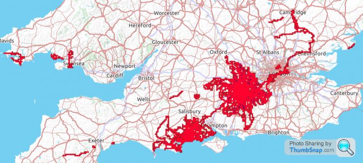
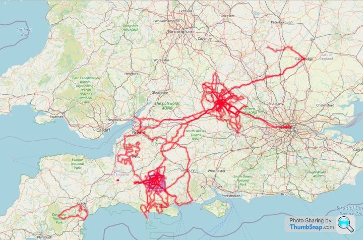
I've also discovered that the furthest two points on a map I can get between on completed "tiles" are Cambridge and Weymouth. Hardly LEJOG/JOGLE territory, but I'm happy with that...
It's a shame that Strava wasn't around further back in my cycling life. This is all since I got my first GPS unit back in late 2013, so there is lots of cycling that I did in South Wales, North Yorkshire, and Essex/Suffolk/Cambridgeshire that doesn't exist in data form. Imagine all the "tiles" I could lay claim to if all those years and miles of cycling had been recorded!
After 6 years of seeing data for the same 25 activities completed in 2014 on the free version of Veloviewer, I've just signed up to Veloviewer Pro for the princely sum of £10. I've done a one-off payment in case I find that I'm not really getting the use out of it.
Is anyone else using it? And if so, what is it you like best, or get most value from on the site.
I've got a massive amount of new/extra data by signing up. I decided to pay after a Strava buddy pointed me toward the 'Explorer Score' section. Basically the map is divided into squares (tiles) and you can then see where you've ridden in terms of the number of tiles. So far so boring, and you might ask "so what?"
But you get a "score" for your exploration. And it's great for someone like me who likes to ride different routes, and generally explore on a bike. I'm not fast, and I'm no great climber so I don't do so good on Strava leader boards. But this is different. It rewards you based only on your willingness to get out and explore routes and places you never have before.
Data such as "Maximum Tile Cluster" and "Maximum Tile Square" intrigue me, and I've just 'wasted' a couple of hours poring over the map trying to work out how I can grab a bigger "Maximum Square"...
my veloviewer summary page said:
Explorer score:
2484 tiles, average of 11.054 mi per tile
Max square 14x14
Max Cluster: 636
What makes it all the more novel (and to some extent frustrating) for me is that I moved to a different part of the country last year, and so I've pretty much started again collecting "tiles" because my old home is just a little bit too far away to ride to anymore. Annoying because now that I can see many more than 25 activities I've realised that I was only a handful of "tiles" away from having a "maximum square" size of 16x16 tiles.2484 tiles, average of 11.054 mi per tile
Max square 14x14
Max Cluster: 636
I can see this becoming quite addictive, and I'm already fixing to head out into areas I haven't ridden before to fill in some blanks on the tile map locally. It will take some effort to even match the 14x14 square around my previous home, but it's something I can build slowly while enjoying the ride, as it will take me to new parts of the New Forest, and into the Cranborne Chase and Dorset AONBs. Well, just as soon as the Coronavirus restrictions are eased anyway.
I've also discovered that the furthest two points on a map I can get between on completed "tiles" are Cambridge and Weymouth. Hardly LEJOG/JOGLE territory, but I'm happy with that...
It's a shame that Strava wasn't around further back in my cycling life. This is all since I got my first GPS unit back in late 2013, so there is lots of cycling that I did in South Wales, North Yorkshire, and Essex/Suffolk/Cambridgeshire that doesn't exist in data form. Imagine all the "tiles" I could lay claim to if all those years and miles of cycling had been recorded!
ukbabz said:
Thought I'd give it a go, not really used it but for £10 worth a punt - who doesn't like data.
For the tiles -
2634 tiles, average of 5.867 km per tile
Max square 13x13 View map
Max Cluster: 323 KML
I can see this being fun, although looking at my current 13x13 it'll be tricky to add extra as there's no roads in the blank tiles.
Same here. I was looking to see how to mop up some gaps in my tile map, but big empty spaces in Dorset/Wiltshire with no roads/villages. So I might have to get creative with a gravel or MTB on bridleways. There's also a gap near Poole harbour which is behind a big metal fence, and a four-tile gap centred on Blandford Camp. Maybe they'll have an open day though? Or perhaps the Royal Signals museum is inside the camp and I can visit that way? For the tiles -
2634 tiles, average of 5.867 km per tile
Max square 13x13 View map
Max Cluster: 323 KML
I can see this being fun, although looking at my current 13x13 it'll be tricky to add extra as there's no roads in the blank tiles.
I'm limited by the sea a couple of tiles to the south of me so there's no scope to expand my Max Square that way, and there would be hundreds of tiles to fill before I get that far, but if I head north eventually I'll get to the bits of Salisbury Plain you'd simply never be allowed to ride through as they are live artillery 'Impact areas'. I suppose if I ever reach the point where that limits my obsession, I could always switch to just colouring in the map of the South West as much as it's possible...
Well that got addictive quite quickly.
23 new tiles visited in 2 days. All just "missing" individual tiles, or groups of 2 or 3 together. Well on the way to "colouring in" the New Forest now, and then I'll look at expanding my Max Square north and west, as those are the only directions open to me.
Not looking forward to one tile in the middle of my square though. It's going to involve some trespassing, I think. Unless there are any businesses operating out of farm buildings on the big estate, in which case I can pretend to be visiting them when they open again post-virus. And scouting around the map, I've zoomed in on a couple of "empty" tiles west of Fordingbridge that definitely have no roads through them, so it's going to have to be bridleways or footpaths to nab some of those.
AndrewT1275 said:
Will Veloviewer only work with Strava?
It looks as though the only way I can use it is to export my ride data to Strava and from there to Veloviewer. Not the end of the world if that's the only way to do it but it just means signing up to another service as I'm not on Strava.
Yeah. It pretty much takes your Strava data and does funky things with it. You can sign up for free, but will be limited to 25 activities to enable you to play around with functionality. If you get a taste for it, signing up to the 'Pro' version costs £10 per year at the moment. And damn, I wish i'd signed up sooner. This tile hunting business is properly addictive. It's like really bad colouring in, but requires riding a lot of miles to fetch the crayons.It looks as though the only way I can use it is to export my ride data to Strava and from there to Veloviewer. Not the end of the world if that's the only way to do it but it just means signing up to another service as I'm not on Strava.
Very addictive. Well it is for me, anyway. It hasn't changed the way I ride too much, just intensified my efforts to ride new routes. Having moved house last year and "left behind" a 14x14 tile 'Max Square' which was built over about 5 years of activities, I have managed to match that from my new home in 10 months, and could expand it to a 16x16 Max Square with just 6 more tiles if I pick the right route. More than the data and the tile-hunting willy waving, though, it's pushing me to ride further from home into some truly stunning scenery. Whereas the "rewards" in Strava often come from riding the same segments again and again and getting faster on them.
So I'd say VeloViewer is worth the £10 for 'Pro', and Strava can be had for free with enough functionality to enjoy both platforms...
AndrewT1275 said:
Thanks for that, I'll give it a go as the Specialized Mission Control app feeds into Strava so it should be straightforward enough to set up once then leave it.
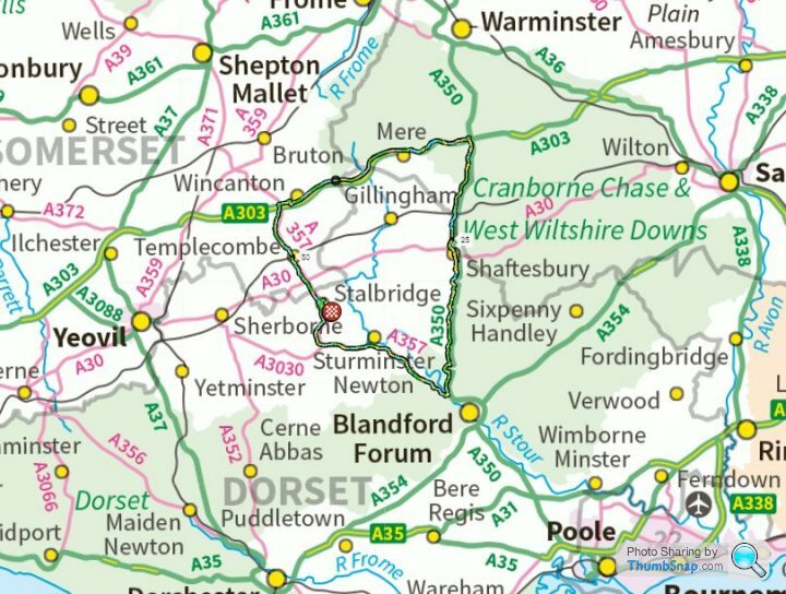
You should check out the North Dorset trailway as it's quite a good way of getting out and colouring in that triangle you've started between Blandford, Shaftesbury and Dorchester.
https://www.northdorsettrailway.org.uk/
I'll definitely check that out at some stage. Annoyingly I rode up Louse Lane, Spetisbury, quite recently, and saw no sign of the Trailway. It's not that far from me, though, so I'll be back that way again.You should check out the North Dorset trailway as it's quite a good way of getting out and colouring in that triangle you've started between Blandford, Shaftesbury and Dorchester.
https://www.northdorsettrailway.org.uk/
I smashed 18 tiles on my last ride out, two near Verwood and the rest all up near Martin/Cranbourne. Cost me an innertube to get one of them, but kinda worth it for the views while I replaced it. That triangle is not my main focus for now though - I'm concentrating on "growing" my Max Square by filling in the square-ish section to the east of the A350 Blandford/Shaftesbury road. After that there are all of the "odds'n'sods" tiles in the eastern part of the New Forest. If I'd signed up earlier to VV I'd have probably varied my routes a little more so as not to leave them unclaimed. Annoying now that I'm going to have to make long trips out to "collect" only a handful of tiles. it's no great shakes, as it's all lovely riding out that way, but i'll have to go over so much previously ridden ground to get to the new stuff.
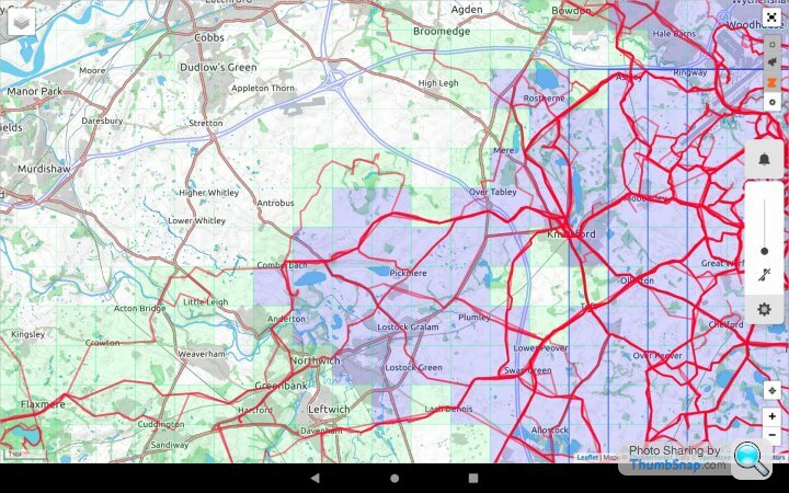
I've also dug out my OS maps for the area, and started marking up the unridden squares on them. Which is in itself annoying because the VV tiles are not based on OS grid squares. It is therefore a little more time-consuming than it might be. but once the maps are marked (carpenters' pencil for paper maps, chinagraph crayon for waterproof maps) it will be easier to make and adapt routes "on the hoof" rather than having to plan tile-hunting rides in detail before I leave. Which means less reliance on tech to navigate on the bike, and the freedom to "go off piste" to achieve the same ends, but still get quickly back on track if I need to hustle home. Some people might find stopping to read a map annoying, but I'm glad of the occasional rest if I'm honest.
I'm also trying not to get entirely fixated on tile hunting for the sole purpose of growing my Square. Due to it's location, the Isle of Purbeck doesn't really contribute much to a 'Max Square' for most people, but my Explorer Map has highlighted some areas of Purbeck that I've not explored yet. Ripe for a shorter MTB ride when the lockdown is over and the Studland Chain Ferry service (hopefully) resumes.
The OS (physical, paper) map thing leads me to another observation. Folk seem so unused to seeing another person reading a map these days that they assume you are hopelessly lost. Just on one ride I had two cyclists stop to ask if I was lost and offer assistance (while observing social distancing too!) and a car driver pull up at a junction, where I was trying to decide on the most efficient route to "bag" another 4 tiles, to ask if I was OK.
Tile hunting has changed the way I ride for the better (for me, at least). Because now I'm riding the same segments less often, and not feeling pressured (I know it's all in my own head) to pull a PR out of the bag. Now it's more about exploring the map, and seeking out interesting places, or place names, just to see what they're like. Places like s
 tterton, Piddletrenthide, God's Blessing Green, Lover, and Bohemia. I'm also building a mental map of roads I can drive on in summer to avoid having to share choked-up 'A' roads with snarled-up holiday traffic. Long term this is, I feel, only going to be good for me. And if I get bored, or have grown my Max Square to it's limit, then I can just put the tile-hunting on the back burner and enjoy re-riding the edited highlights of this area just for the sake of cycling.
Some Gump said:
Now you've pointed it out, can you explain the rules?
Many squares i have been through bit they don't get coloured in...
Not sure I've been "doing it" long enough to be able to explain that. Beyond "check you privacy settings" and "do an update" of all you activities on VeloViewer, all I can suggest is opening each (offending) activity from the VeloViewer activities list individually on Veloviewer, because that apparently causes the tiles to be checked and ticked off using your actual GPS data points, rather than "virtual" datapoints every 100 metres (hence the straight-ish lines on the map). Or try asking Ben Lowe (Mr VeloViewer himself) on one of the forums or Strava clubs. Which is a point in itself - join the Strava clubs ('Ride Every Tile', and/or 'Ride Every Tile - From Home'). I'm not sure if you have to join the Strava clubs, but you do have to surrender some privacy on both Strava and VeloViewer in order to appear on leader boards, I think.Many squares i have been through bit they don't get coloured in...
Beyond those suggestions, you'll have to accept an "I don't know" as your answer from me. I have no computer coding expertise, nor am I involved with running any of the sites/apps I'm commending to you...
Sorry!
ETA:
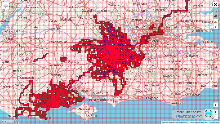
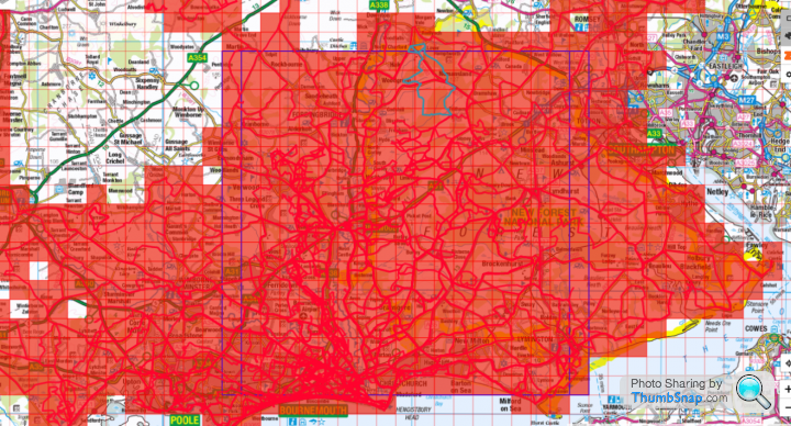
It may be down to map settings. You can customise the opacity of the shading, the density of the colours, and also you may have your map set to show your 'Max Cluster'. Squares (tiles) don't count toward your Max cluster unless you've ridden the four adjacent tiles on it's edges too. So a single missing tile within your 'Cluster' knocks your score down by 5 tiles, I believe. Riding that single missing tile should (and again I'm still learning the "rules" myself) give you that tile, and also all four surrounding tiles should then count toward your Max Cluster score.
See how my Max Cluster looks...
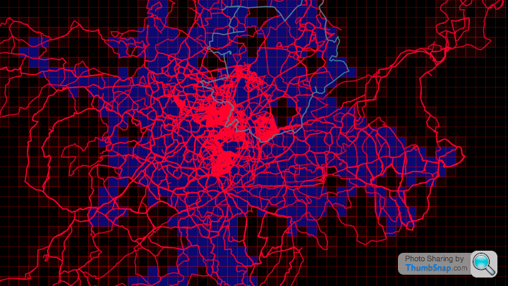
...with some adjustments made to colours, etc, to account for my colour-blindness. Those five-tile "crosses" within the blue area are all single individual tiles that have caused the adjacent four tiles to be discounted from my Max Cluster score. The blue tiles count toward the Max Cluster, the green (they are green, right?) ones are tiles I've ridden but don't count due to a missing tile on at least one adjacent side. Riding through each of those centre tiles would cause that tile, and the surrounding four tiles, to all count toward my score. In my case, those particular tiles are out of reach due to a house move, and until I expand my Max Cluster at my new home to a greater size than my initial Max Cluster, I won't be able to see that on my map (as far as I'm currently aware). Hope that helps...
Edited by yellowjack on Monday 27th April 14:53
Some Gump said:
Bingo! Thanks mate.
All of my missing ones are 5 tile clusters. So riding the middle tile should colour in the missing one i guess.
This is a good thing. It's motivational the same way that Strava Multiple Ride Mapper.was back in 2013. Time to explore!
Reading through some of the blogs and Strava 'Ride Every Tile' club comments, it seems that the Max Cluster was a later addition to the Max Square score. Specifically added to keep motivation high for folk who, for whatever reason, have their Max Square limited in size by geography or by an "Impossible Tile". It's another target to keep you interested.All of my missing ones are 5 tile clusters. So riding the middle tile should colour in the missing one i guess.
This is a good thing. It's motivational the same way that Strava Multiple Ride Mapper.was back in 2013. Time to explore!
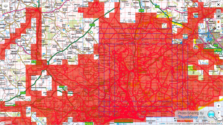
Back in Farnborough I was blessed. There were no impossible tiles that I knew of, it was the 'home counties' so plenty of roads, even out in the countryside, and I could grow my Max Square in every direction, meaning shorter trips that still netted new tiles. Down in Bournemouth, though, I'm hemmed in by the sea, the Solent, and limited by impossible, or near impossible tiles in three directions. I'm a long way off hitting those tiles yet, but I can't see my way beyond a 39x39 Max Square on paper. Fawley Oil Refinery accounts for one "impossible" tile (short of getting a job there I can't see a way past the perimeter fence), ditto the Port Of Southampton and Marchwood Military Port. Another tile is entirely (or so it seems anyway) within the Lulworth Tank Gunnery range danger area (although it's too far south to limit my Max Square size). The ones that will hamper my Square-growing attempts (if I ever reach them) will be the tiles in the Larkhill Artillery Impact Area on Salisbury Plain Training Area. It's an offence to enter them, and you'd have to be spectacularly foolhardy to even want to, given that it's been an artillery range for decades and is potentially laced with unexploded ordnance. It won't trouble me for years, yet, though. The number of tiles needed to grow a square increases exponentially with each expansion. I've got about 200 tiles to make my 14x14. I've probably got another 150 to 200 tiles that would contribute to expansion in stages. But I'd need over 1500 tiles to complete a 39x39 square so I'm barely half way there, and the further away I push the northern and western sides of my Max Square, the longer the journey I need to make to "collect" each tile, so it becomes less efficient in terms of tiles per mile ridden. For this reason, I will also concentrate on "colouring in" the map to grow my Max Cluster around Bournemouth.
irn_bru_ce said:
yellowjack said:
I've also dug out my OS maps for the area, and started marking up the unridden squares on them. Which is in itself annoying because the VV tiles are not based on OS grid squares. It is therefore a little more time-consuming than it might be. but once the maps are marked (carpenters' pencil for paper maps, chinagraph crayon for waterproof maps) it will be easier to make and adapt routes "on the hoof" rather than having to plan tile-hunting rides in detail before I leave. Which means less reliance on tech to navigate on the bike, and the freedom to "go off piste" to achieve the same ends, but still get quickly back on track if I need to hustle home. Some people might find stopping to read a map annoying, but I'm glad of the occasional rest if I'm honest.
If you have a smart phone then have a search for the app called "explorer helper for veloviewer" , it provides the tilemap and all the coloured squares as well as your current position, so very easy to go exploring on the hoof. The live position is very handy for time when your somewhere you kind of shouldn't be so you can just enter a square by a few pixels then leave and know you still have it bagged.For now I shall stick to OS maps and pencil lines thereon. My latest outing was set to be disappointing. I set out to get a tile that was beside the sea, with only a tiny portion of it on land. When I got to the access point to descend from the clifftop to the undercliff it was clear that something was up. The clifftop was now at the base of the cliff, with no undercliff path to be seen. The road down was closed with warnings of unstable cliffs and (dangerously) soft sand. I got as close to the edge as I dared to take a few photos of the "impossible" tile. But when I got home there it was, ticked off and "filled in". There was just enough clifftop left to get me those precious few pixels into the tile. And because I feared getting home "empty handed" I also pushed on a few more miles and rode a gravel-topped sea wall to bag another two tiles. So in the end the ride bore more fruit than I'd planned despite me expecting less from it when I arrived at my "target" tile. Off out now to see if I can pick off a couple of tiles that are preventing me from growing my Max Square.
AndrewT1275 said:
Upgraded to the full Veloviewer and have started looking at my tiles. Prepare yourselves.....
Max square 2x2
Max cluster 3
In my defence I've only started tracking rides using an app in the last 2 weeks. Also, because it's quieter and I've got a bit more time on my hands than usual I've been doing bigger loops so have lots of holes.
There's a track I'll often use on a ride but haven't lately which goes straight though a current gap and will give me a 5x5 square. And when the Sandbanks ferry reopens it will be a tile bonanza.
This is going to be so addictive!
One thing I can't get to work though is the list and chart views on the routes page. Any ideas?
Welcome to the madhouse! With a small Max Square, expansion should be quick. When it gets bigger you either have to ride a lot further for fewer tiles, or end up driving out to riding spots. Which side of the Sandbanks Ferry are you? I'm on the Bournemouth side, and although they won't help my Max Square much I want to "colour in" Purbeck as much as possible. I'm going to have to hit the gravel bike, or my MTB soon, because I'm starting to hit tiles where the bridleways aren't very forgiving on my road bike.Max square 2x2
Max cluster 3
In my defence I've only started tracking rides using an app in the last 2 weeks. Also, because it's quieter and I've got a bit more time on my hands than usual I've been doing bigger loops so have lots of holes.
There's a track I'll often use on a ride but haven't lately which goes straight though a current gap and will give me a 5x5 square. And when the Sandbanks ferry reopens it will be a tile bonanza.
This is going to be so addictive!
One thing I can't get to work though is the list and chart views on the routes page. Any ideas?
I picked up six tile the other night, on a past-midnight spin up to Godshill, and eventually as far as Downton, near Salisbury. Loads of tiles to get out on Cranbourne Chase/Chalke Valley though. There are patches where four or five tiles could grow my Max Square too, but I'm plotting an assault on Cranbourne Chase over a few rides, leaving one or two nearer tiles to keep it at 14x14, so that when I finally fill those closer tiles there's a significant leap up in my Max Square size. Then, when lockdown restrictions are eased, I can concentrate on joining my Bournemouth-based cluster with my current Max Cluster centred on Farnborough.
Expansion for me is limited to West and North only. I've reached the Southerly limit unless I get a kayak, and there are several tiles in Southampton Docks and Fawley Oil Refinery which might be a little difficult to get if I try to push East.
My "local" Max Square (there's another 14x14 to match it based out of my old home in Farnborough). Not bad for just under a year here in Bournemouth, and even better when I think that I didn't sign up to VeloViewer Pro until just three weeks ago. It gets really addictive really quickly!
Some Gump said:
Went square chasing today. Now on 13x13 
Next ride would have been able to make that 14x14 (choice if 2 directions) except i ballsed up todays route leaving a gap in the new area i filled in.
I only use strave.route builder at the moment, and if i save as tcx i get no turn by turn prompts despite the web saying i should. Guess i'll switch back to gpx because although the prompts always come too late they at least exist!
Does anyone know of any clever place doing route planning with the vv map squares? Still not quite sure whether my missed square was me missing a prompt, or just setting the route missing a square - i was trying to multitask children and 2 maps in different colours and scales and it was quite frustrating.
I'm not sure it would help with route planning, and it isn't much use to low-tech me, but...Next ride would have been able to make that 14x14 (choice if 2 directions) except i ballsed up todays route leaving a gap in the new area i filled in.
I only use strave.route builder at the moment, and if i save as tcx i get no turn by turn prompts despite the web saying i should. Guess i'll switch back to gpx because although the prompts always come too late they at least exist!
Does anyone know of any clever place doing route planning with the vv map squares? Still not quite sure whether my missed square was me missing a prompt, or just setting the route missing a square - i was trying to multitask children and 2 maps in different colours and scales and it was quite frustrating.
irn_bru_ce said:
If you have a smart phone then have a search for the app called "explorer helper for veloviewer" , it provides the tilemap and all the coloured squares as well as your current position, so very easy to go exploring on the hoof. The live position is very handy for time when your somewhere you kind of shouldn't be so you can just enter a square by a few pixels then leave and know you still have it bagged.
...this app sounds like it might help to avoid leaving an area having overlooked a tile or two. I'd use it myself, I think, but being a cheapskate on PAYG with a donated El-Cheapo brand 3G phone means I don't have the memory/battery life on my device to run it until I upgrade. It doesn't sound so much like a route planning tool, rather more like a "changed my mind off the cuff" assistant while you're on the bike.I've missed a few tiles recently where they've been just off the map sheet I've taken with me, but adjacent to tiles I've been riding on that map, if that makes sense. So the app would have shown me that there were adjacent tiles, and a route into them. Then again, though, I don't want to get too obsessed with "tiling" to the point where I don't re-ride tiles I've already ticked off, because that would deprive me of some really fantastic roads, trails, and views over the beautiful Dorset/Wiltshire/Hampshire coast and countryside. Sometimes I feel that I've become a little too fixated on the "tiles" to the point where I've gone out in the dark and stayed out past midnight just to nab a tile or two, when I really ought to have ridden a more sensible loop close to home. The issue is that I'm now in a position where I need to ride 100km + to grab any tiles that would count toward growing my Max Square. And for a slow-poke like me that means at least half a day out on the bike. I'll probably have to start driving to destinations sooner than I'd have liked, and ride from car parks rather than starting all my rides from home, if I really want to tick off the greatest number of tiles per ride. Otherwise I'll be re-riding dozens of tiles before I can even reach new ones. The idea of "riding every tile from home" was a nice one, but it's difficult when you can't expand South due to living near the sea. I probably should have moved Leicestershire if I was going to get serious about "tiling"!

ukbabz said:
Just seen that there are leader boards for veloviewer, so can see how fellow members of the pistonheads club are doing on their tiles this year..
It's not a surprise that yellowjack is winning this year!
https://veloviewer.com/leaderboard/y/2020/t/explc/...
The link doesn't work for me, but...It's not a surprise that yellowjack is winning this year!
https://veloviewer.com/leaderboard/y/2020/t/explc/...

That will soon change. I've almost exhausted the "new" tiles I can reach within a four-hour ride now. I only moved here in May 2019, and due to DIY, etc, didn't really start riding until July 2019. It's only since the sunny weather this spring that I've really pushed out from Bournemouth on longer rides (not as much cycling over the wet winter we've had as I would have liked). When I signed up to VV in April 2020 I found that I'd already grabbed a lot of "new" tiles without realising it.
My new tile rate will begin to slow down now, as they get further and further away. But I'm still inspired to ride, simply because the area (East Dorset, Sout West Hampshire, and South Wiltshire mainly) is absolutely beautiful to ride in, and there are many quiet roads to take advantage of.
It also depends upon which data fields you choose to look at. 'Gruffy' wipes the floor with everyone from an absolute number of tiles due to his long distance racing. But his "tile" collection is often long strings which don't count toward clusters or squares. besides which, I'm doing this because I enjoy it, not to "win anything", not even "virtual pub bragging rights". I'm well aware that there are a great many people out there who, given my time and inclination, could collect a great deal more tiles far more swiftly than I can due to my low average speed on most rides. Even when I'm "fast for me", I'm still pretty slow...
Edited by yellowjack on Wednesday 13th May 09:42
Solocle said:
Liking the OS layer!

I've always viewed connecting different rides as the challenge. In particular, there's a big pile in the North I need to look at.
But I'm also considering making a bigger max cluster by connecting my two hubs.
Connecting two 'hubs'? I'm in that same boat...
I have two 'hubs' based around my old and new addresses. The 'string' that joins them is the result of a single ride a few years ago (my longest ever ride). Between the New Forest and the Basingstoke area, via Winchester, is a mostly 1 tile wide 'string'. If I could widen that to 3 tiles wide I think it would allow me to join those two 'hubs' and claim a far larger Max Cluster. But any ride that helps with that would necessarily mean a long day on the bike, or involve driving to a location and riding from the boot of the car, where I much prefer riding from home, really.
I've got my fingers crossed that ferry services start running again now. The chain ferry at Sandbanks would help to shorten my journey into Purbeck, and the Lymington ferry to the Isle Of Wight would help me explore over on the island. In the meantime, though, there are plenty of unexplored tiles out there that I can venture into...
ukbabz said:
Just plotted another ride for the weekend, should take in 14 new tiles and increase mine to a 15x15.
I do find it tricky to work out where to go next! some longer ride outs to get much further than that but is interesting trying to plan it all
I do find it tricky to work out where to go next! some longer ride outs to get much further than that but is interesting trying to plan it all

This is part of the appeal. Yesterday I went off in search of 8 tiles along the Piddle Valley (Oi! No sniggering at the back!) between Bere Regis, Bovington and Wareham. I got sidetracked on a "draw a big willy" segment a Strava buddy created in Lytchett Matravers and didn't claim a single new tile.
I've started using Strava route creator now, just to see how far I need to ride to claim new tiles out west. Rides of 70+ miles are only returning a small handful of tiles now. And many of those tiles are on OS map sheets I don't have at home, too. So I might have to dig out my old Edge500 for a while and follow set routes (not a favourite pastime of mine, I prefer to "ride casual" and explore a bit). The "ride time" estimates end up way off though, usually because I take my road bike onto gravel tracks and have to slow down to nurse the tyres over gravel to avoid flats. So I end up coming back having ridden for a longer time than planned, but I've covered fewer miles than intended. It's a wee bit frustrating some days, but on the whole the views from some of the bridleways I've ended up on have more than made up for the shorter distances covered.
colin_p said:
I've always fancied getting into trig-pointing via bicycle.
It would provide proper goals and excuses for all you tile hunters! Grab some tiles and bag some trigs at the same time.
Nooooooooo! It would provide proper goals and excuses for all you tile hunters! Grab some tiles and bag some trigs at the same time.
I shouldn't ask really, as it'd just be something else to obsess about. What exactly is "trig-pointing"? Is it something that requires some sort of documentary evidence (brass-rubbing or photograph of the ID plate on the trig point) or is it GPS based? Because I've found some pretty obscure trig-points when I've been out riding. The sort that are hidden away in heathland or woodland in places you might not expect to find one.
AndrewT1275 said:
I'm just north of the ferry in Poole. I get so bored of the route up through Broadstone in order to get to the nice quiet routes north of Wimborne so I see the ferry as essential for easy access to the countryside to the south.
There are loads of nice tracks across the Purbecks and the views are stunning. If it ever reopens, the garden at the Scott Arms is great for lunch and views of Corfe. Some of my riding is done with a small handful of OAPs on ebikes and their idea of a good ride is 30 - 40 miles spread over 6 hours with at least one coffee stop and two pub stops for refreshments then lunch. It's a nice day out and quite relaxing for me being 30 years younger although I can't see it happening at all this year.
I was heading to Wareham Forest today to ride a "Gravel Smash" 12 mile segment. I'm getting bored with my route through Bournemouth to Wimborne and Lytchett Minster too. So I thought I'd change it up a little and just follow my (GPS) compass. Got as far as Bournemouth Uni before road closures (resurfacing works) sent me off into the unknown (to me, at least). I ended up on a cycle path past Tower Park, heading to Upton. And that was where my planned route got punted into touch and I headed north to Corfe Mullen and Sturminster Marshall. A spell on the A31 before Mapperton and a detour on a bridle path for miles and miles to Thornicombe, before coming back through Wimborne, Bear Cross and Kinson. And the map I'd taken? The top edge finished at Upton so I was "riding blind" in places i'd never ridden before after that. There are loads of nice tracks across the Purbecks and the views are stunning. If it ever reopens, the garden at the Scott Arms is great for lunch and views of Corfe. Some of my riding is done with a small handful of OAPs on ebikes and their idea of a good ride is 30 - 40 miles spread over 6 hours with at least one coffee stop and two pub stops for refreshments then lunch. It's a nice day out and quite relaxing for me being 30 years younger although I can't see it happening at all this year.
Managed 11 new tiles, mind, through shear blind luck!
Some Gump said:
How have you one that???
It looks like you have vv and strava route builder together somehow? Please share your secret
https://blog.veloviewer.com/veloviewer-chrome-exte...It looks like you have vv and strava route builder together somehow? Please share your secret
Top left of the Strava Route Builder - click the "cog" icon and switch on Veloviewer Explorer. That adds the tile outlines, and shows your completed tiles, Max Square, and Max Cluster. I think it imports all the colours and settings direct from Veloviewer, so set them up there. Oh, and you need to have downloaded the Chrome Extension for veloviewer/strava too.
I believe you do need to minimise your privacy settings for sharing the info between the two sites though. Ben (Lowe - 'Mr VeloViewer') has made assurances about privacy, but to use the feature on Route Builder you do have to turn some of the privacy settings down. I forget where on the veloviewer pages these settings are, but I'm sure I found them by reading through the blogs on VV.
Sorry if some of my terminology isn't spot on - I'm a curmudgeonly middle-aged cyclist, not a tech boffin, but if I can manage it I'm sure most people can...

Devastating loss of 40 tiles-worth of data on Friday!
My Garmin Forerunner 910 XT watch seems to have failed to write the data correctly and it is corrupted. No amount of messing and fussing with help forums or online repair tools helps, due to the ANT+ upload only "feature" of the watch. So I can't bust the corrupted file out of it's watch-bound "jail" to even try to repair it.
12 hours out on the bike, over 10 hours moving, and 125.17 miles ridden. And yet all the tiles I "earned" during the ride are unclaimed. Damn it!
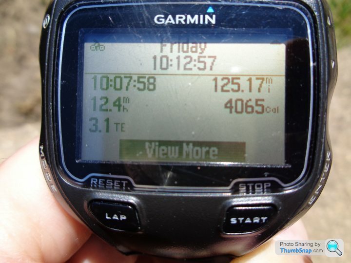
Anyone know what that "3.1 TE" field is on the watch's activity history screen? Not a data field I recall seeing before, so maybe something to do with why the activity won't upload?
Loads of tiles in the New Forest around Beaulieu Road Station, up into Marchwood, over to Redbridge on the Southampton side, up as far as Ashfield, taking in the Test Way, finishing near Nomansland via West Wellow, etc. All ridden from home, hence the large distance covered. Looks like I'll now have to ride those tiles again, but I think I'll take the bike to the tiles in my car next time, and park somewhere central to nab them all again, as I don't really have time to go re-riding the whole route from home next time out...
This ride was supposed to lay the foundations for a big increase in my Max Square over the next couple of weeks. First world problems and all, but it feels like a big personal setback for me. After this setback, the watch recorded two activities on Saturday, both walks (but recorded as runs to the watch) and uploaded them as normal. Typically it's not a short 'throwaway' walk or jog that the watch decides to bugger up, but a pretty big ride with lots of achievements worth uploading. Grrr!
My Garmin Forerunner 910 XT watch seems to have failed to write the data correctly and it is corrupted. No amount of messing and fussing with help forums or online repair tools helps, due to the ANT+ upload only "feature" of the watch. So I can't bust the corrupted file out of it's watch-bound "jail" to even try to repair it.
12 hours out on the bike, over 10 hours moving, and 125.17 miles ridden. And yet all the tiles I "earned" during the ride are unclaimed. Damn it!
Anyone know what that "3.1 TE" field is on the watch's activity history screen? Not a data field I recall seeing before, so maybe something to do with why the activity won't upload?
Loads of tiles in the New Forest around Beaulieu Road Station, up into Marchwood, over to Redbridge on the Southampton side, up as far as Ashfield, taking in the Test Way, finishing near Nomansland via West Wellow, etc. All ridden from home, hence the large distance covered. Looks like I'll now have to ride those tiles again, but I think I'll take the bike to the tiles in my car next time, and park somewhere central to nab them all again, as I don't really have time to go re-riding the whole route from home next time out...
This ride was supposed to lay the foundations for a big increase in my Max Square over the next couple of weeks. First world problems and all, but it feels like a big personal setback for me. After this setback, the watch recorded two activities on Saturday, both walks (but recorded as runs to the watch) and uploaded them as normal. Typically it's not a short 'throwaway' walk or jog that the watch decides to bugger up, but a pretty big ride with lots of achievements worth uploading. Grrr!
TCX said:
'Devastating' must have a new definition these days, that s not
Yes. Quite. I'm clearly "hamming it up" for an online audience, hoping that someone, somewhere, will know of a solution to this issue so that I can "get back my lost tiles".Alternatively, I have a different definition of "devastating" to you? The problem has certainly "devastated" my mood this weekend...
Solocle said:
Personally, having ridden the route, use gotoes to add timestamps based on an appropriate average speed, set the activity to followers-only/private so that you don't get some unwarranted KOMs, and voila! Veloviewer will tick off those tiles.
https://gotoes.org/strava/Add_Timestamps_To_GPX.ph...
For clarity, I have no file available to add time stamps to. Can I use that tool to add time stamps to a GPS "planned" route to make it look like an activity?https://gotoes.org/strava/Add_Timestamps_To_GPX.ph...
It was a complex route, to be honest. lots of off-road gravel tracks around forest areas, all navigated off an OS map. There was an outline plan when I started, but it changed/evolved many times when faced with the ground compared with the map. So I'm not even sure I could genuinely trace my exact route from memory now.
Ill take a better look at your link when I have more time, but I'm not great with computers really, nor with tech generally. It sounds pathetic but I'd probably need someone to sit beside me and "hold my hand" through a process like that. And they'd probably need earplugs for the shouting and swearing too!
Edit to add
OK. Gave it a try. Made a route on Strava route builder as best as I could remember it. That worked, so I used the tool you linked to. That worked too. So I uploaded the "faked" ride to Strava (kept private for my eyes only, and marked as fake in my activity notes). That worked as well, and now those "missing" tiles have been claimed on VeloViewer.
Got to say, it feels like a bit of a "hollow victory" if I'm honest. Keeping my average speed realistic to my ride, and using the tool to "take elevation into account" resulted in only two PRs. Probably unrepeatable by me, but not greatly unrealistic in terms of overall leaderboards. Certainly no flag-worthy KOMs or trophies falsely claimed, which is good. Probably actually robbed myself of a few high placings on some of the more benign forest gravel tracks.
Anyway. It has given me the tiles I'd lost, so thanks for that. I can always ride those tiles again, too, to get a more honest result if I want to. But it has "set the record straight" for now.
Veloviewer Score up from 98.118 to 98.135 (possibly those two new PRs, but I think it would have gone up by more with the "real" ride data)
42 new tiles visited, up from 2639 to 2681 (I think this has claimed 2 more tiles than I intended)
Max Cluster remains at 636
Max Square up from 14x14 to 18x18
If nothing else, this little 'Lost Data' saga has demonstrated how bad my obsessive behaviour still is. I though I was getting better, but clearly not. Ho-Hum...
The newly claimed tiles are all in the eastern section of the New Forest, and up from Totton, coming back via Redlynch and Nomansland (what a cheeky climb it was coming out of there, too!) Still a few to explore on the shore of The Solent, if indeed they are accessible. But industry and dockyards all with security and limited access may put a stop to riding (or even walking) in some of those tiles...
Edited by yellowjack on Monday 18th May 14:28
Gassing Station | Pedal Powered | Top of Page | What's New | My Stuff