French road trip plans
Discussion


Planning a road trip around France this summer. Doing a circuit around France taking in-
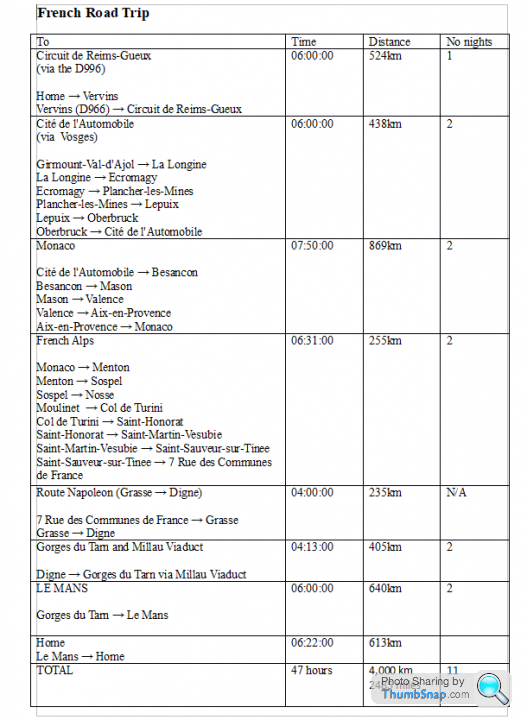
1) Circuit de Reims-Gueux
2) NATIONAL MOTOR MUSEUM FRANCE (Cité de l'Automobile)
3) French Alps
4) Monaco / Cannes / Nice
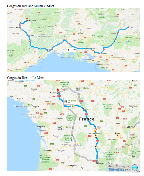
5) Millau Viaduct
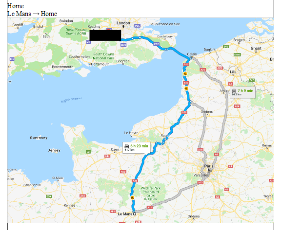
6) LE MANS
Should cover around 2076 miles over 11 days. Spending about 2 days at each location including travel.
Anyone who has done a similar trip and has any recommendations please add a comment. Plan on do some mountain biking and kayaking as well as visiting museums and sites.
1) Circuit de Reims-Gueux
2) NATIONAL MOTOR MUSEUM FRANCE (Cité de l'Automobile)
3) French Alps
4) Monaco / Cannes / Nice
5) Millau Viaduct
6) LE MANS
Should cover around 2076 miles over 11 days. Spending about 2 days at each location including travel.
Anyone who has done a similar trip and has any recommendations please add a comment. Plan on do some mountain biking and kayaking as well as visiting museums and sites.
GTSilver said:
RedRose123 said:
Planning a road trip around France this summer. Doing a circuit around France taking in-
1) Circuit de Reims-Gueux
2) NATIONAL MOTOR MUSEUM FRANCE (Cité de l'Automobile)
3) French Alps
4) Monaco / Cannes / Nice
5) Millau Viaduct
6) LE MANS
Should cover around 2076 miles over 11 days. Spending about 2 days at each location including travel.
Anyone who has done a similar trip and has any recommendations please add a comment. Plan on do some mountain biking and kayaking as well as visiting museums and sites.
Off to Mulhouse in a couple of weeks time, via Circuit de Reims-Gueux (dropped in there three years ago - places reeks of motor racing history, well worth going). Just a short three day blast but expect to put on 1500 miles (currently the run in period ends in about amount 800 miles 1) Circuit de Reims-Gueux
2) NATIONAL MOTOR MUSEUM FRANCE (Cité de l'Automobile)
3) French Alps
4) Monaco / Cannes / Nice
5) Millau Viaduct
6) LE MANS
Should cover around 2076 miles over 11 days. Spending about 2 days at each location including travel.
Anyone who has done a similar trip and has any recommendations please add a comment. Plan on do some mountain biking and kayaking as well as visiting museums and sites.
 ) having obtained a 3 day pass from Mrs GTSilver.
Will staying a couple of night in the Vosges area ( close to the Col du Grand Balloon) so one day in Cité de l'Automobile and one day seeking out some interesting roads in that region should = fun.
Happy to post some thoughts on anything that may be of use/interest once I'm back.

clemoug said:
Hi,
I'm French and used to live in the Vosges region and now living in Grenoble.
Are you doing your trip with the tuscan? If you're looking for nice twisty driving roads I can help since I used to drive my taimar around both of these regions quite a lot.
When will be your trip in summer? If you fancy you can send me the screenshots of the planned route around these two regions (I didn't manage to open them to figure out the roads you planned...)
Thanks Clemoug. Not taking the Tuscan this year but are still looking for some nice twisty roads. Any route suggestions will be greatly appreciated. Trip so far is about 2600 miles. Plan to take Tuscan next year. I'm leaving the UK on Sunday 3rd May. Rather than screenshots I have added links to Google Maps. I'm French and used to live in the Vosges region and now living in Grenoble.
Are you doing your trip with the tuscan? If you're looking for nice twisty driving roads I can help since I used to drive my taimar around both of these regions quite a lot.
When will be your trip in summer? If you fancy you can send me the screenshots of the planned route around these two regions (I didn't manage to open them to figure out the roads you planned...)
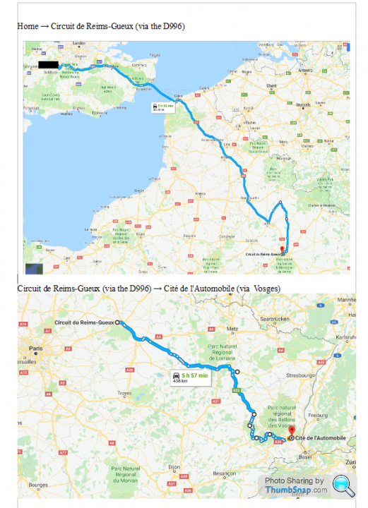
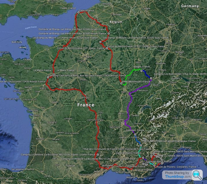
Circuit de Reims-Gueux ?D996 ? Vosges
Reims to Vosges
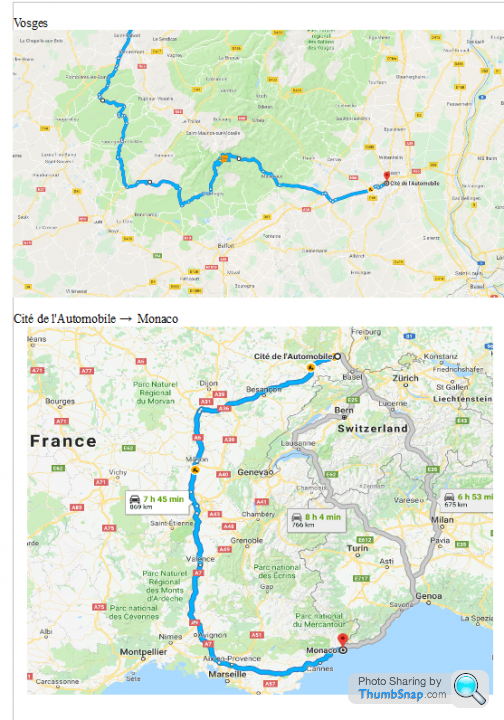
Monaco ? Alps, plan to continue along the D64, head down the D900 then D902 which is where my hotel is. Pass is closed until the 1st June. I cannot plot the route using Google Maps until Pass open.
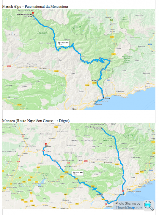
Alps
Edited by RedRose123 on Saturday 26th May 14:23
Edited by RedRose123 on Saturday 26th May 14:25
clemoug said:
I would advise you to use this kind of map which I think is much more user friendly
https://www.viamichelin.fr/ then zoom in some place in france and it appears on the right of your screen "retrouvez la carte michelin" where you can clic and have a proper michelin map.
for the part after epinal, I changed a bit to give you much better sceneries and nicer roads, but i's quite a longer way.
https://www.google.co.uk/maps/dir/Circuit+du+Reims...
and if you have a bit more time, this one is woth the extra road
https://www.google.co.uk/maps/dir/Circuit+du+Reims...
it goes towards Colmar (very cute old center town) and then take the "route des vins" (wine's road if I try any translation), the road going through wineyards, crossing very cute villages like Eguisheim (I think ranked among the prettiest village in France if I'm not wrong) or Gueberschwihr, all with very particular architecture typical from Elsass and you can visit some wine producers (very famous white wine in the region). Perhaps at this season you might see some storks. This region is lovely at this season.
the second part in the alps, I would need the previous step to help you. The one you sent is too much in the south of France, I don't really know the places there. I'm located more in Grenoble area.
I hope this wil give you some ideas...
ps: do you have a phone running android?
Thanks for the route update through the national park. It only adds 1:30 to the journey so well worth the detour (may do the longer route next year in the Tuscan). Not using an Android but one of the later TomToms. For each section of the route I have created a GPX file (using Google Maps and http://www.gpsvisualizer.com). I have uploaded these files onto the TomTom and can access them through "My Routes". Will also be taking print outs of all the routes in case of TomTom issues.https://www.viamichelin.fr/ then zoom in some place in france and it appears on the right of your screen "retrouvez la carte michelin" where you can clic and have a proper michelin map.
for the part after epinal, I changed a bit to give you much better sceneries and nicer roads, but i's quite a longer way.
https://www.google.co.uk/maps/dir/Circuit+du+Reims...
and if you have a bit more time, this one is woth the extra road
https://www.google.co.uk/maps/dir/Circuit+du+Reims...
it goes towards Colmar (very cute old center town) and then take the "route des vins" (wine's road if I try any translation), the road going through wineyards, crossing very cute villages like Eguisheim (I think ranked among the prettiest village in France if I'm not wrong) or Gueberschwihr, all with very particular architecture typical from Elsass and you can visit some wine producers (very famous white wine in the region). Perhaps at this season you might see some storks. This region is lovely at this season.
the second part in the alps, I would need the previous step to help you. The one you sent is too much in the south of France, I don't really know the places there. I'm located more in Grenoble area.
I hope this wil give you some ideas...
ps: do you have a phone running android?
For the Grenoble area this is my planned route so far -
https://www.google.co.uk/maps/dir/3+Rue+du+Stade,+...
Thanks for your help with the route planning.
Edited by RedRose123 on Sunday 27th May 13:08
clemoug said:
so I added some great roads near genoble and at the end before Castellane. However I think it would be preferable to fully enjoy the roads and sceneries you'll be crossing to split it into two days to avoid a bit more the french motorways (quite expensive and often boring drivingwhile seeing nothing of the places you cross :-( but very fine if you need to rush).
So I can suggest this version, trying to escape the busy road between monestier de clermont and lus la croix haute where you'll find lots of camper vans, caravans and tourists heading South, quite difficult to overtake on this section as well. I added instead teh pass between Séchiliennes and la Morte, which is usually not busy but one of the finest driving road around to my mind, then very nice scenery heading down the mountain.
then crossing the devoluy mountain, which is completely different atmosphere from the previous places you've crossed earlier.
And finally, a must do before reaching your destination is the Verdon canyon. that road is dramatic!
https://www.google.co.uk/maps/dir/3+Rue+du+Stade,+...
or a bit shorter version of the Verdon canyon
https://www.google.co.uk/maps/dir/3+Rue+du+Stade,+...
or this version a bit different where you do not cross grenoble but the Vercors mountain.
https://www.google.co.uk/maps/dir/3+Rue+du+Stade,+...
no point of taking the A49 motorway too much since the D1532 is nice to use (almost 90 kph all along, easy to overtake) and setting among wallnut trees forests (nuts, noix in French,are famous in that region). If you wanna find some good quality nut oil (not sure about the proper english word), you have lots of producers along that road. Then go up towards pont en royans, famous for it's houses "hanging" above the river, you'll be surrounded by high limestones cliffs there, then heading South and going down the Rousset pass. A very fine road indeed as well with beautiful scenery all the way down. Arriving in Die which is well know for its "clairette", kind of champagne/ sparkling white wine. From there you can start feeling you're arriving in the "South" of France, getting closer to the Provence region, with architecture and vegetation becoming very different.
The end in Verdon Canyon is either that way of the first one above.
Ifever you split this stage into two days, I can add you some stuff ;-)
I was asking about android because there is an app running on android called Camsam which is quite usefull here ( I don't know if it's used as well in the UK?) by telling you when you're approaching a speed camera (most of the fixed ones, and many mobile ones)
I hope I didn't mess too much in your trip planning!
Option one looks the best for me. TomTom has been updated. After the 09:30 mins drive to Gorges Du Verdon, have planned a rest day to explore the canyon involving a short 02:20 mins drive around the Canyon followed by some kind of activity (kayaking, climbing, walking, etc). Following day, off to Monaco to hopefully see lots of super cars. So I can suggest this version, trying to escape the busy road between monestier de clermont and lus la croix haute where you'll find lots of camper vans, caravans and tourists heading South, quite difficult to overtake on this section as well. I added instead teh pass between Séchiliennes and la Morte, which is usually not busy but one of the finest driving road around to my mind, then very nice scenery heading down the mountain.
then crossing the devoluy mountain, which is completely different atmosphere from the previous places you've crossed earlier.
And finally, a must do before reaching your destination is the Verdon canyon. that road is dramatic!
https://www.google.co.uk/maps/dir/3+Rue+du+Stade,+...
or a bit shorter version of the Verdon canyon
https://www.google.co.uk/maps/dir/3+Rue+du+Stade,+...
or this version a bit different where you do not cross grenoble but the Vercors mountain.
https://www.google.co.uk/maps/dir/3+Rue+du+Stade,+...
no point of taking the A49 motorway too much since the D1532 is nice to use (almost 90 kph all along, easy to overtake) and setting among wallnut trees forests (nuts, noix in French,are famous in that region). If you wanna find some good quality nut oil (not sure about the proper english word), you have lots of producers along that road. Then go up towards pont en royans, famous for it's houses "hanging" above the river, you'll be surrounded by high limestones cliffs there, then heading South and going down the Rousset pass. A very fine road indeed as well with beautiful scenery all the way down. Arriving in Die which is well know for its "clairette", kind of champagne/ sparkling white wine. From there you can start feeling you're arriving in the "South" of France, getting closer to the Provence region, with architecture and vegetation becoming very different.
The end in Verdon Canyon is either that way of the first one above.
Ifever you split this stage into two days, I can add you some stuff ;-)
I was asking about android because there is an app running on android called Camsam which is quite usefull here ( I don't know if it's used as well in the UK?) by telling you when you're approaching a speed camera (most of the fixed ones, and many mobile ones)
I hope I didn't mess too much in your trip planning!
clemoug said:
In addition to the traditional car spotting places in Monaco, I would advice to have a look there:
https://www.google.fr/maps/@43.7382378,7.418611,3a...
very cute garage with amazing classics inside (cars displayed inside are changing every few days), stored in a place like a cave. I used to work in Monaco for some months and I was stopping there very often on my way back from work. Each time new surprises for me (from bugatti type 35 to ferarri F40, F430 scuderia, ex Stoner's ducatti desmoceidici,stratos...) and the owner was very welcoming towards "tourists" like me ( I mean I was obviously not there to buy any of their treasure!)
Thanks, I'll take a look when I'm in Monaco.https://www.google.fr/maps/@43.7382378,7.418611,3a...
very cute garage with amazing classics inside (cars displayed inside are changing every few days), stored in a place like a cave. I used to work in Monaco for some months and I was stopping there very often on my way back from work. Each time new surprises for me (from bugatti type 35 to ferarri F40, F430 scuderia, ex Stoner's ducatti desmoceidici,stratos...) and the owner was very welcoming towards "tourists" like me ( I mean I was obviously not there to buy any of their treasure!)
Gassing Station | Roads | Top of Page | What's New | My Stuff