How did explorers find land?
Discussion


Looking at the extent of the British Empire it seemed to encompass hundreds of tiny islands in the midst of huge oceans. Without modern aids how were they found? The mark 1 eyeball (even with a telescope) might miss a speck of land in the distance, or sailing just a few miles in a different direction it would never be seen as it was over the horizon.
I'm sure there must have been local help, but without this was it just down to luck?
SD.
I'm sure there must have been local help, but without this was it just down to luck?
SD.
shed driver said:
Looking at the extent of the British Empire it seemed to encompass hundreds of tiny islands in the midst of huge oceans. Without modern aids how were they found? The mark 1 eyeball (even with a telescope) might miss a speck of land in the distance, or sailing just a few miles in a different direction it would never be seen as it was over the horizon.
I'm sure there must have been local help, but without this was it just down to luck?
SD.
Sheer luck (or lack of it, depending on the manner in which you first interact with the previously unknown land mass).I'm sure there must have been local help, but without this was it just down to luck?
SD.
Indications of nearby land still under the horizon might be decreasing water depth, land birds or insects, floating vegetation, smoke or unusual cloud formations.
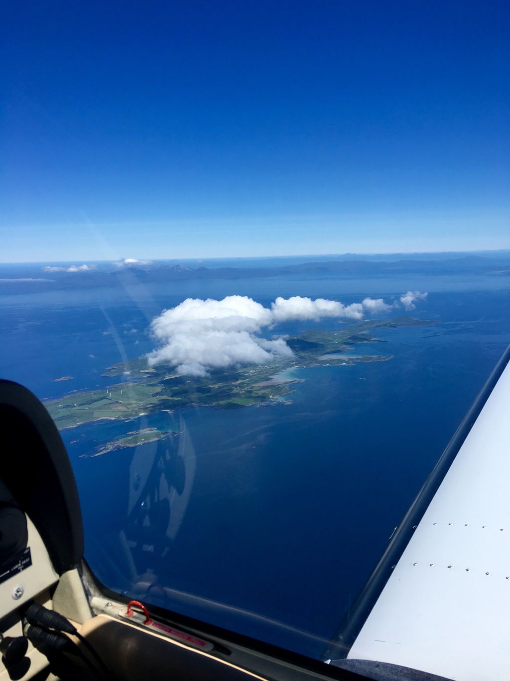
I've sailed the Pacific a number of times, including visiting some very remote, low-lying atolls and reef islands. It is surprising how far away you can spot them, and bigger islands even more easily by clouds as mentioned above. I took this photo off western Scotland which shows the effect (orographic lift) nicely.
Oh, and don't forget, they will not necessarily have always found them. They would have missed many before eventually making landfall or sighting one.
Oh, and don't forget, they will not necessarily have always found them. They would have missed many before eventually making landfall or sighting one.
You don't have to be very high up to see a long way.
100 feet up a sailing ship mast you can see 12 miles to the horizon.
A decent island with a hill on it can be seen from a long way away.
A lot of islands were rumoured to exist, mis-reported in various locations by merchant ships, explorers, hydrographers and 'surveyors' went looking for them.
I think some sectors of some seas were just divvied up or claimed by the various european powers in advance of actually knowing what was there?
Background reading: https://www.amazon.co.uk/History-Navigation-Dag-Pi...
Before cross staffs, log lines, sextants, chronometers etc, early sailors like the Polynesians found islands by looking at cloud formations and birds.
Before cross staffs, log lines, sextants, chronometers etc, early sailors like the Polynesians found islands by looking at cloud formations and birds.
With great difficulty, I think. You could call Australia and remote island but not a small one by any stretch. Yet the early discovery and exploration of it is very hit and miss with people apparently missing it all together, or landing at various points and not realising it was one land mass.
I've just dug out Down Under by Bill Bryson as I remember he has a brilliant explanation of this somewhere.
I've just dug out Down Under by Bill Bryson as I remember he has a brilliant explanation of this somewhere.
ashenfie said:
The mapping was done very accurately by cook and the power of triangles. Prior to that they were basically a bunch of chancers
Not really, the stars were a perfect reference (when visible). That's latitude; longitude needed accurate timekeeping which took a bit longer (Harrison etc). But storms etc made it a risky occupation.LimaDelta said:
I've sailed the Pacific a number of times, including visiting some very remote, low-lying atolls and reef islands. It is surprising how far away you can spot them, and bigger islands even more easily by clouds as mentioned above. I took this photo off western Scotland which shows the effect (orographic lift) nicely.
Oh, and don't forget, they will not necessarily have always found them. They would have missed many before eventually making landfall or sighting one.
Is that Gigha?Oh, and don't forget, they will not necessarily have always found them. They would have missed many before eventually making landfall or sighting one.
w1bbles said:
LimaDelta said:
I've sailed the Pacific a number of times, including visiting some very remote, low-lying atolls and reef islands. It is surprising how far away you can spot them, and bigger islands even more easily by clouds as mentioned above. I took this photo off western Scotland which shows the effect (orographic lift) nicely.
Oh, and don't forget, they will not necessarily have always found them. They would have missed many before eventually making landfall or sighting one.
Is that Gigha?Oh, and don't forget, they will not necessarily have always found them. They would have missed many before eventually making landfall or sighting one.
I have just read a book about Cook's last voyage and at one stage - possibly just before they got to the Sandwich Is - it mentions more seaweed being seen floating past and more birds.
Also I think the Polynesian navigators could see the reflected blue light from shallower atoll waters on the clouds forming above. I have noticed this myself on clouds over glacier-fed blue lakes in NZ.
Also I think the Polynesian navigators could see the reflected blue light from shallower atoll waters on the clouds forming above. I have noticed this myself on clouds over glacier-fed blue lakes in NZ.
some bloke said:
I have just read a book about Cook's last voyage and at one stage - possibly just before they got to the Sandwich Is - it mentions more seaweed being seen floating past and more birds.
Also I think the Polynesian navigators could see the reflected blue light from shallower atoll waters on the clouds forming above. I have noticed this myself on clouds over glacier-fed blue lakes in NZ.
Yep, there were loads of signs, sea birds, fish and plants that tend to live in coastal waters. Also a lot of the locals will know where land is, so they also followed rumours. Also I think the Polynesian navigators could see the reflected blue light from shallower atoll waters on the clouds forming above. I have noticed this myself on clouds over glacier-fed blue lakes in NZ.
A person in a crows nest could spot something on the surface of the ocean 12-15 miles away. So an island that goes up 50 odd metres can be spotted over 100 miles away. Also sheet volume. Hundreds of ships over hundreds of years with inaccurate navigation (by modern standards) meant that even though the odds were small there was enough time at sea that you'd find almost everything eventually.
Also remember that there was a lot of sharing of information - they weren't just sailing out into the blue in the hope of hitting something.
From the 17th century onwards the Royal Navy had a very finely-honed system for recovering, collating and distributing information collected by all its ships at sea. Captains and Masters were required to keep both logbooks (a navigational record) and journals (more in-depth narrative) which would include sightings of any land encountered on a voyage, and Masters and officers were trained in basic hydrography, cartography and sketching so they could make quick sketch maps, make additions to charts and produce sketches or even full watercolour illustrations of islands and land masses spotted.
These documents would all be turned into the Navigation Office (from the 1790s the Hydrographic Office) at the Admiralty, which would collate all this information to update its charts, pilot guides and notices to mariners. When an RN captain was setting out on a voyage or into an area of operations, the Admiralty would provide him with a complete set of documents that represented the current state of knowledge, including any sightings of islands or land.
Officers, masters and master's mates usually kept personal journals alongside the officially required ones, building up years and years of experience which they could refer to later. Masters especially were expected to consult and exchange information with their colleagues wherever possible. And they would make use of local expertise where their own information ran out, either by asking locals or sometimes even hiring them as pilots or guides.
Merchant mariners did the same - keeping journals and exchanging and collecting information. Any good shipowner would keep and issue even the most basic information recorded by their captains, because even a hazy sighting of an island with a snap sighting on a rough day to get the position could be a vital lead.
Of course, the quality of all this data could be suspect, and sometimes led to 'false positives' where one mistaken sighting (seeing cloud masses and some floating seaweed and reporting an island) then prompts others with that information to do the same, and so you get 'phantom islands'. As late as the 1920s the RN was sending hydrographic and oceanographic ships into the Pacific, the Indian Ocean and the Southern Ocean to finally confirm one way or the other whether these actually existed.
Edited by 2xChevrons on Wednesday 16th July 11:46
Gassing Station | Boats, Planes & Trains | Top of Page | What's New | My Stuff